Filters: Tags: American Samoa (X)
135 results (92ms)|
Filters
|
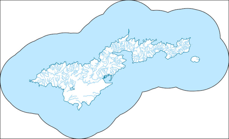
This data release is comprised of a set of eight time travel map shapefiles (two tsunami inundation zones and four travel times) for use in GIS software applications and two population exposure by travel time tables (residents and nonresidences) for use in GIS software applications and other standalone spreadsheet applications. The travel time map was generated using the Pedestrian Evacuation Analyst model (version 1.0.1 for ArcGIS 10.5) from the USGS (https://geography.wr.usgs.gov/science/vulnerability/tools.html). The travel time analysis uses ESRI's Path Distance tool to find the shortest distance across a cost surface from any point in the hazard zone to a safe zone. This cost analysis considers the direction...
Near-surface site characteristics are critical for accurately modeling ground motion, which in turn influences seismic hazard analysis and design of critical infrastructure. Currently, there are many strong motion accelerometers within the Advanced National Seismic System (ANSS) that are missing this information. We use a Geographic Information Systems (GIS) based framework to intersect the site coordinates of approximately 5,500 ANSS accelerometers located throughout the United States and its territories with geology and velocity information. We consider: (1) surficial geology from digitized geologic maps (Horton, 2017; Wilson et al., 2015; Sherrod et al., 2007; Bawiec, 1999; Saucedo, 2005; Bedrossian et al., 2012;...
Categories: Data;
Types: Map Service,
OGC WFS Layer,
OGC WMS Layer,
OGC WMS Service;
Tags: ANSS,
Alabama,
American Samoa,
Arizona,
Arkansas,

Geospatial data includes structures and other selected map features.

Geospatial data is comprised of government boundaries.

The Geographic Names Information System (GNIS) is the Federal standard for geographic nomenclature. The U.S. Geological Survey developed the GNIS for the U.S. Board on Geographic Names, a Federal inter-agency body chartered by public law to maintain uniform feature name usage throughout the Government and to promulgate standard names to the public. The GNIS is the official repository of domestic geographic names data; the official vehicle for geographic names use by all departments of the Federal Government; and the source for applying geographic names to Federal electronic and printed products of all types.

The Geographic Names Information System (GNIS) is the Federal standard for geographic nomenclature. The U.S. Geological Survey developed the GNIS for the U.S. Board on Geographic Names, a Federal inter-agency body chartered by public law to maintain uniform feature name usage throughout the Government and to promulgate standard names to the public. The GNIS is the official repository of domestic geographic names data; the official vehicle for geographic names use by all departments of the Federal Government; and the source for applying geographic names to Federal electronic and printed products of all types.
Surveys for immature life stages of the Samoan swallowtail butterfly (Papilio godeffroyi) were conducted on 117 individually marked host trees (Micromelum minutum) in eight forest stands on Tutuila Island, American Samoa, at approximately monthly intervals during 2013-2014. The eight sites were mostly in or adjacent to the National Park of American Samoa (NPSA), but one site was sampled near the western tip of Tutuila, outside NPSA. An additional 74 host trees were assessed for phenological status in the eight stands but were not surveyed for Papilio. The dataset contains information on the number of leaves that were surveyed for Papilio. Based on this number, the estimated surface area and dry mass of leaves that...
Surveys for immature life stages of the Samoan swallowtail butterfly (Papilio godeffroyi) were conducted on 117 individually marked host trees (Micromelum minutum) in eight forest stands on Tutuila Island, American Samoa, at approximately monthly intervals during 2013-2014. The eight stands were mostly in or adjacent to the National Park of American Samoa (NPSA), but one stand was sampled near the western tip of Tutuila, outside NPSA. An additional 74 host trees were assessed for phenological status in the eight stands but were not surveyed for Papilio. The dataset contains information on physical and habitat characteristics of the 191 total trees.
Surveys for immature life stages of Papilio godeffroyi were conducted on 117 individually marked host trees (Micromelum minutum) in eight forest stands on Tutuila Island, American Samoa, at approximately monthly intervals during 2013-2014. The eight stands were mostly in or adjacent to the National Park of American Samoa (NPSA), but one site was sampled near the western tip of Tutuila, outside NPSA. Papilio life stages included eggs, eggshells, larvae, pupae, and exuviae, which were taken to the laboratory at American Samoa Community College for examination and processing. Specimens were reared (live specimens) or assessed (dead or inert specimens) to determine their reproductive outcome and rates of parasitism....

This data represents the map extent for current and historical USGS topographic maps for the United States and Territories, including 1 X 2 Degree, 1 X 1 Degree, 30 X 60 Minute, 15 X 15 Minute, 7.5 X 7.5 Minute, and 3.75 X 3.75 Minute. The grid was generated using ESRI ArcInfo GIS software.

The National Hydrography Dataset (NHD) is a feature-based database that interconnects and uniquely identifies the stream segments or reaches that make up the nation's surface water drainage system. NHD data was originally developed at 1:100,000-scale and exists at that scale for the whole country. This high-resolution NHD, generally developed at 1:24,000/1:12,000 scale, adds detail to the original 1:100,000-scale NHD. (Data for Alaska, Puerto Rico and the Virgin Islands was developed at high-resolution, not 1:100,000 scale.) Local resolution NHD is being developed where partners and data exist. The NHD contains reach codes for networked features, flow direction, names, and centerline representations for areal water...
The National Hydrography Dataset (NHD) is a feature-based database that interconnects and uniquely identifies the stream segments or reaches that make up the nation's surface water drainage system. NHD data was originally developed at 1:100,000-scale and exists at that scale for the whole country. This high-resolution NHD, generally developed at 1:24,000/1:12,000 scale, adds detail to the original 1:100,000-scale NHD. (Data for Alaska, Puerto Rico and the Virgin Islands was developed at high-resolution, not 1:100,000 scale.) Local resolution NHD is being developed where partners and data exist. The NHD contains reach codes for networked features, flow direction, names, and centerline representations for areal water...
The National Hydrography Dataset (NHD) is a feature-based database that interconnects and uniquely identifies the stream segments or reaches that make up the nation's surface water drainage system. NHD data was originally developed at 1:100,000-scale and exists at that scale for the whole country. This high-resolution NHD, generally developed at 1:24,000/1:12,000 scale, adds detail to the original 1:100,000-scale NHD. (Data for Alaska, Puerto Rico and the Virgin Islands was developed at high-resolution, not 1:100,000 scale.) Local resolution NHD is being developed where partners and data exist. The NHD contains reach codes for networked features, flow direction, names, and centerline representations for areal water...
WHISPers stands for Wildlife Health Information Sharing Partnership - event reporting system. It is a web-based repository for sharing basic information about historic and ongoing wildlife mortality (death) and morbidity (illness) events. The system possesses a searchable archive of wildlife mortality and morbidity event data that is available to the public. The information is opportunistically collected and does not reflect all the mortality events that occur in North America.
The travel time map was generated using the Pedestrian Evacuation Analyst model (version 1.0.1 for ArcGIS 10.5) from the USGS (https://geography.wr.usgs.gov/science/vulnerability/tools.html). The travel time analysis uses ESRI's Path Distance tool to find the shortest distance across a cost surface from any point in the hazard zone to a safe zone. This cost analysis considers the direction of movement and assigns a higher cost to steeper slopes, based on a table contained within the model. The analysis also adds in the energy costs of crossing different types of land cover, assuming that less energy is expended walking along a road than walking across a sandy beach. To produce the time map, the evacuation surface...
Categories: Data;
Types: Downloadable,
Map Service,
OGC WFS Layer,
OGC WMS Layer,
Shapefile;
Tags: American Samoa,
evacuation,
hazards,
modeling,
pedestrian,
Layers of geospatial data include contours, boundaries, land cover, hydrography, roads, transportation, geographic names, structures, and other selected map features.

Layers of geospatial data include contours, boundaries, land cover, hydrography, roads, transportation, geographic names, structures, and other selected map features.

Layers of geospatial data include contours, boundaries, land cover, hydrography, roads, transportation, geographic names, structures, and other selected map features.
Brackish groundwater (BGW), defined for this assessment as having a dissolved-solids concentration between 1,000 and 10,000 milligrams per liter is an unconventional source of water that may offer a partial solution to current (2016) and future water challenges. In support of the National Water Census, the U.S. Geological Survey has completed a BGW assessment to gain a better understanding of the occurrence and character of BGW resources of the United States as an alternative source of water. Analyses completed as part of this assessment relied on previously collected data from multiple sources, and no new data were collected. One of the most important contributions of this assessment was the creation of a database...
Categories: Data;
Types: Citation,
Downloadable,
Map Service,
OGC WFS Layer,
OGC WMS Layer,
OGC WMS Service;
Tags: Alaska,
American Samoa,
Guam,
Hawaii,
Puerto Rico,
|

|
