Filters
Date Range
Extensions
Types
Contacts
Categories
Tag Types
Tag Schemes
|
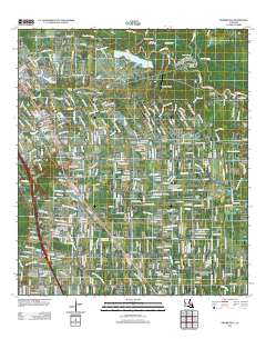
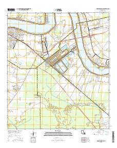
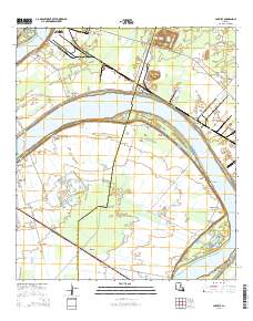
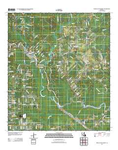
Layered GeoPDF 7.5 Minute Quadrangle Map. Layers of geospatial data include orthoimagery, roads, grids, geographic names, elevation contours, hydrography, and other selected map features.
Tags: 7.5 x 7.5 minute,
Ascension,
Downloadable Data,
EarthCover,
East Baton Rouge, All tags...
GeoPDF,
Imagery and Base Maps,
Livingston,
Louisiana,
Map,
Prairieville, LA,
U.S. National Grid,
US,
US Topo,
US Topo Historical,
United States,
contour,
geographic names,
hydrography,
imageryBaseMapsEarthCover,
orthoimage,
structures,
topographic,
transportation, Fewer tags
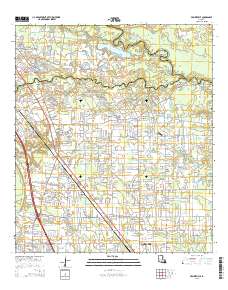
Layered GeoPDF 7.5 Minute Quadrangle Map. Layers of geospatial data include orthoimagery, roads, grids, geographic names, elevation contours, hydrography, and other selected map features.
Tags: 7.5 x 7.5 minute,
Ascension,
Downloadable Data,
EarthCover,
East Baton Rouge, All tags...
GeoPDF,
Imagery and Base Maps,
Livingston,
Louisiana,
Map,
Prairieville, LA,
Public Land Survey System,
U.S. National Grid,
US,
US Topo,
US Topo Historical,
United States,
boundary,
contour,
geographic names,
hydrography,
imageryBaseMapsEarthCover,
orthoimage,
structures,
topographic,
transportation,
woodland, Fewer tags
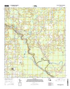
Layered GeoPDF 7.5 Minute Quadrangle Map. Layers of geospatial data include orthoimagery, roads, grids, geographic names, elevation contours, hydrography, and other selected map features.
Tags: 7.5 x 7.5 minute,
Ascension,
Downloadable Data,
EarthCover,
French Settlement, LA, All tags...
GeoPDF,
Imagery and Base Maps,
Livingston,
Louisiana,
Map,
Public Land Survey System,
U.S. National Grid,
US,
US Topo,
US Topo Historical,
United States,
boundary,
contour,
geographic names,
hydrography,
imageryBaseMapsEarthCover,
orthoimage,
structures,
topographic,
transportation,
woodland, Fewer tags
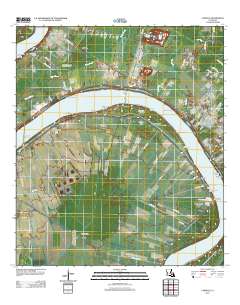
Layered GeoPDF 7.5 Minute Quadrangle Map. Layers of geospatial data include orthoimagery, roads, grids, geographic names, elevation contours, hydrography, and other selected map features.
Tags: 7.5 x 7.5 minute,
Ascension,
Carville, LA,
Downloadable Data,
EarthCover, All tags...
GeoPDF,
Iberville,
Imagery and Base Maps,
Louisiana,
Map,
U.S. National Grid,
US,
US Topo,
US Topo Historical,
United States,
contour,
geographic names,
hydrography,
imageryBaseMapsEarthCover,
orthoimage,
structures,
topographic,
transportation, Fewer tags
Layered GeoPDF 7.5 Minute Quadrangle Map. Layers of geospatial data include orthoimagery, roads, grids, geographic names, elevation contours, hydrography, and other selected map features.
Tags: 7.5 x 7.5 minute,
Ascension,
Assumption,
Donaldsonville, LA,
Downloadable Data, All tags...
EarthCover,
GeoPDF,
Imagery and Base Maps,
Louisiana,
Map,
Public Land Survey System,
St. James,
U.S. National Grid,
US,
US Topo,
US Topo Historical,
United States,
boundary,
contour,
geographic names,
hydrography,
imageryBaseMapsEarthCover,
orthoimage,
structures,
topographic,
transportation,
woodland, Fewer tags
The Geographic Names Information System (GNIS) is the Federal standard for geographic nomenclature. The U.S. Geological Survey developed the GNIS for the U.S. Board on Geographic Names, a Federal inter-agency body chartered by public law to maintain uniform feature name usage throughout the Government and to promulgate standard names to the public. The GNIS is the official repository of domestic geographic names data; the official vehicle for geographic names use by all departments of the Federal Government; and the source for applying geographic names to Federal electronic and printed products of all types.
Tags: Acadia,
Allen,
Antarctica,
Antarctica,
Ascension, All tags...
Assumption,
Avoyelles,
BGN,
Beauregard,
Bienville,
Board on Geographic Names,
Borough,
Bossier,
Caddo,
Calcasieu,
Caldwell,
Cameron,
Catahoula,
Census Area,
Claiborne,
Commonwealth,
Concordia,
County,
De Soto,
District,
Downloadable Data,
East Baton Rouge,
East Carroll,
East Feliciana,
Evangeline,
Feature class,
Feature coordinates,
Feature county,
Feature description,
Feature designation,
Feature history,
Feature indentification,
Feature name,
Feature state,
Franklin,
GNIS,
GeoPackage,
Geographic Names,
Geographic Names Full Model,
Geographic Names Information System,
Geographic feature,
Geographic name,
Geographical feature,
Geographical name,
Grant,
Iberia,
Iberville,
Jackson,
Jefferson,
Jefferson Davis,
LA,
LaSalle,
Lafayette,
Lafourche,
Lincoln,
Livingston,
Louisiana,
Madison,
Morehouse,
Municipio,
Natchitoches,
National Geographic Names Information System (GNIS),
National Geographic Names Information System (GNIS),
Official feature name,
Open Geospatial Consortium GeoPackage 1.2,
Orleans,
Ouachita,
Outlying Area,
Parish,
Place name,
Plaquemines,
Pointe Coupee,
Populated Place,
Rapides,
Red River,
Richland,
Sabine,
St. Bernard,
St. Charles,
St. Helena,
St. James,
St. John the Baptist,
St. Landry,
St. Martin,
St. Mary,
St. Tammany,
State,
Tangipahoa,
Tensas,
Terrebonne,
Territories,
Territory,
Topographic Map,
U.S. Board on Geographic Names,
U.S. Geological Survey,
US,
USA,
USBGN,
USGS,
Union,
United States,
United States,
United States,
Variant name,
Vermilion,
Vernon,
Washington,
Webster,
West Baton Rouge,
West Carroll,
West Feliciana,
Winn,
antarctic,
database,
economy,
environment,
feature,
gazetteer,
geographic,
geographic names,
geographical,
geography,
geospatial,
imageryBaseMapsEarthCover,
inlandWaters,
location,
map,
name,
place,
placename,
society,
structure,
topographic map,
toponymy, Fewer tags
The National Hydrography Dataset (NHD) is a feature-based database that interconnects and uniquely identifies the stream segments or reaches that make up the nation's surface water drainage system. NHD data was originally developed at 1:100,000-scale and exists at that scale for the whole country. This high-resolution NHD, generally developed at 1:24,000/1:12,000 scale, adds detail to the original 1:100,000-scale NHD. (Data for Alaska, Puerto Rico and the Virgin Islands was developed at high-resolution, not 1:100,000 scale.) Local resolution NHD is being developed where partners and data exist. The NHD contains reach codes for networked features, flow direction, names, and centerline representations for areal water...
Tags: Administrative watershed units,
Administrative watershed units,
Amite,
Area of Complex Channels,
Area to be submerged, All tags...
Ascension,
Basin,
Basin,
Bay/Inlet,
Boundaries,
Boundary,
Bridge,
Canal/Ditch,
Coastline,
Connector,
Dam/Weir,
Downloadable Data,
Drainage areas for surface water,
Drainageway,
East Baton Rouge,
East Feliciana,
Esri Shapefile nan,
Estuary,
Flow direction network,
Flume,
ForeShore,
Franklin,
Gaging Station,
Gate,
HU-8,
HU-8 Subbasin,
HU10,
HU12,
HU14,
HU16,
HU2,
HU4,
HU6,
HU8,
HU8_08070202,
HUC,
Hazard Zone,
Hydrographic,
Hydrography,
Hydrography,
Hydrography,
Hydrologic Unit Code,
Hydrologic Units,
Iberville,
Ice mass,
Inundation Area,
LA,
Levee,
Lincoln,
Line,
Livingston,
Lock Chamber,
Louisiana,
MS,
Marsh,
Mississippi,
National Hydrography Dataset (NHD),
National Hydrography Dataset (NHD) Best Resolution,
National Hydrography Dataset (NHD) Best Resolution,
Nonearthen Shore,
Orthoimage,
Playa,
Point,
PointEvent,
Pond,
Rapids,
Rapids,
Reach,
Reach code,
Reef,
Region,
Reservoir,
Rock,
Sea/Ocean,
Shapefile,
Sink/Rise,
Sounding Datum Line,
Special Use Zone,
Special Use Zone Limit,
Spillway,
St. Helena,
Stream,
Stream/River,
Sub-basin,
Sub-region,
Subbasin,
Submerged Stream,
Subregion,
Subwatershed,
Surface water systems,
Swamp,
Topographic,
Tunnel,
US,
Underground Conduit,
United States,
WBD,
WBD,
Wall,
Wash,
Water Intake Outflow,
Waterfall,
Watershed,
Watershed Boundaries,
Watershed Boundary Dataset,
Watershed Boundary Dataset,
Well,
Wilkinson,
artificial path,
boundaries,
dams,
drainage systems and characteristics,
inlandWaters,
lakes,
ngda,
rivers, Fewer tags
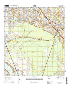
Layered GeoPDF 7.5 Minute Quadrangle Map. Layers of geospatial data include orthoimagery, roads, grids, geographic names, elevation contours, hydrography, and other selected map features.
Tags: 7.5 x 7.5 minute,
Ascension,
Carville, LA,
Downloadable Data,
EarthCover, All tags...
GeoPDF,
Iberville,
Imagery and Base Maps,
Louisiana,
Map,
Public Land Survey System,
U.S. National Grid,
US,
US Topo,
US Topo Historical,
United States,
boundary,
contour,
geographic names,
hydrography,
imageryBaseMapsEarthCover,
orthoimage,
structures,
topographic,
transportation,
woodland, Fewer tags
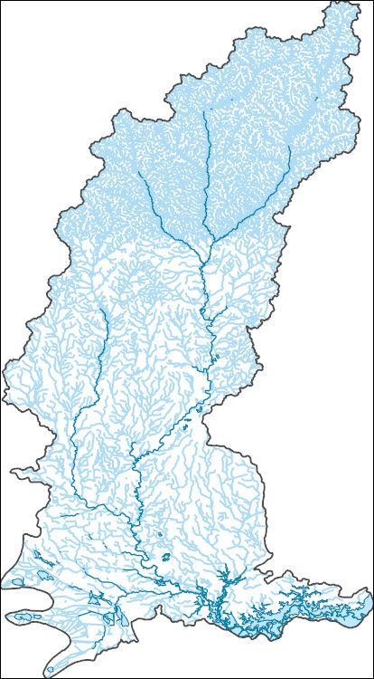
The Watershed Boundary Dataset (WBD) is a comprehensive aggregated collection of hydrologic unit data consistent with the national criteria for delineation and resolution. It defines the areal extent of surface water drainage to a point except in coastal or lake front areas where there could be multiple outlets as stated by the "Federal Standards and Procedures for the National Watershed Boundary Dataset (WBD)" "Standard" (https://pubs.usgs.gov/tm/11/a3/). Watershed boundaries are determined solely upon science-based hydrologic principles, not favoring any administrative boundaries or special projects, nor particular program or agency. This dataset represents the hydrologic unit boundaries to the 12-digit (6th level)...
Tags: 10-digit,
12-digit,
14-digit,
16-digit,
2-digit, All tags...
4-digit,
6-digit,
8-digit,
AR,
Acadia,
Adams,
Alcorn,
Alexander,
Allen,
Amite,
Arkansas,
Arkansas,
Ascension,
Ashley,
Assumption,
Attala,
Avoyelles,
Ballard,
Basin,
Beauregard,
Benton,
Bienville,
Bolivar,
Bollinger,
Bradley,
Butler,
Calcasieu,
Caldwell,
Calhoun,
Calloway,
Cameron,
Cape Girardeau,
Carlisle,
Carroll,
Catahoula,
Chester,
Chickasaw,
Chicot,
Choctaw,
Claiborne,
Clark,
Clay,
Cleveland,
Coahoma,
Columbia,
Concordia,
Copiah,
Craighead,
Crittenden,
Crockett,
Cross,
Dallas,
DeSoto,
Desha,
Downloadable Data,
Drew,
Dunklin,
Dyer,
East Baton Rouge,
East Carroll,
East Feliciana,
Esri Shapefile nan,
Evangeline,
Faulkner,
Fayette,
Franklin,
Fulton,
Garland,
Gibson,
Grant,
Graves,
Greene,
Grenada,
HU-2,
HU-2 Region,
HU2_08,
HUC,
Hardeman,
Harrison,
Haywood,
Hempstead,
Henderson,
Henry,
Hickman,
Hinds,
Holmes,
Hot Spring,
Howard,
Humphreys,
Hydrography,
Hydrologic Unit Code,
Hydrologic Units,
IL,
Iberia,
Iberville,
Illinois,
Iron,
Issaquena,
Jackson,
Jefferson,
Jefferson Davis,
KY,
Kentucky,
LA,
LaSalle,
Lafayette,
Lafourche,
Lake,
Lauderdale,
Lawrence,
Leake,
Lee,
Leflore,
Lincoln,
Livingston,
Lonoke,
Louisiana,
MO,
MS,
Madison,
Marshall,
McCracken,
McNairy,
Mississippi,
Mississippi,
Missouri,
Monroe,
Montgomery,
Morehouse,
Natchitoches,
National Watershed Boundary Dataset (WBD),
National Watershed Boundary Dataset (WBD),
Nevada,
New Madrid,
Obion,
Oktibbeha,
Orleans,
Ouachita,
Panola,
Pemiscot,
Perry,
Phillips,
Pike,
Plaquemines,
Poinsett,
Pointe Coupee,
Polk,
Pontotoc,
Prairie,
Prentiss,
Pulaski,
Quitman,
Randolph,
Rapides,
Region,
Reynolds,
Richland,
Saline,
Scott,
Shapefile,
Sharkey,
Shelby,
St. Bernard,
St. Charles,
St. Francis,
St. Francois,
St. Helena,
St. James,
St. John the Baptist,
St. Landry,
St. Martin,
St. Mary,
St. Tammany,
Ste. Genevieve,
Stoddard,
Sub-basin,
Sub-region,
Subwatershed,
Sunflower,
TN,
Tallahatchie,
Tangipahoa,
Tate,
Tennessee,
Tensas,
Terrebonne,
Tippah,
Tipton,
Tunica,
US,
Union,
United States,
Vermilion,
Vernon,
WBD,
Warren,
Washington,
Watershed,
Watershed Boundary Dataset,
Wayne,
Weakley,
Webster,
West Baton Rouge,
West Carroll,
West Feliciana,
White,
Wilkinson,
Winn,
Woodruff,
Yalobusha,
Yazoo,
Yell,
inlandWaters, Fewer tags
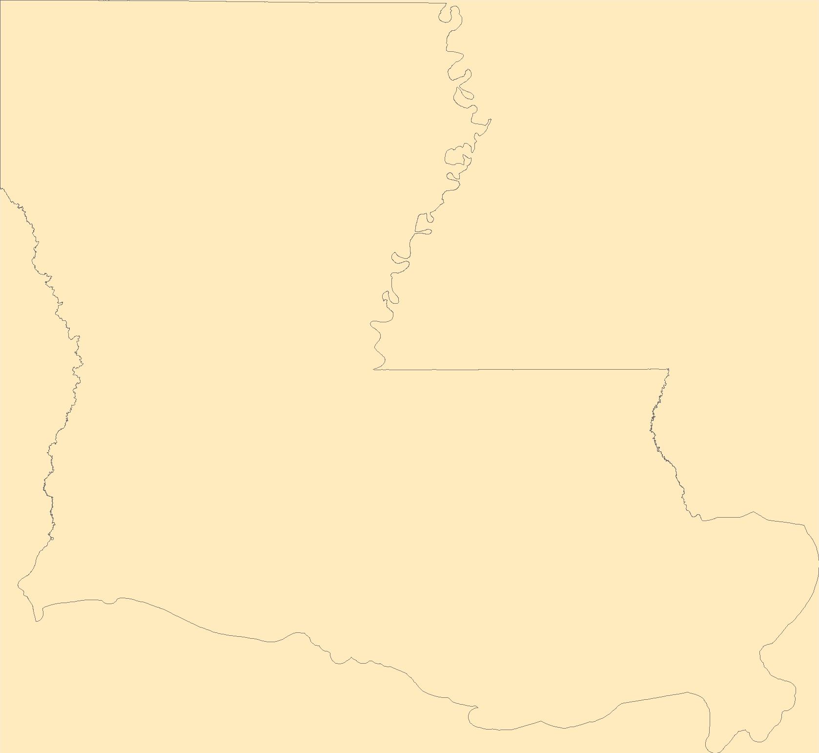
Geospatial data is comprised of government boundaries.
Tags: Acadia,
Allen,
Ascension,
Assumption,
Avoyelles, All tags...
Beauregard,
Bienville,
Bossier,
Boundaries,
Caddo,
Calcasieu,
Caldwell,
Cameron,
Catahoula,
Claiborne,
Concordia,
County or Equivalent,
De Soto,
Downloadable Data,
East Baton Rouge,
East Carroll,
East Feliciana,
Evangeline,
Franklin,
GeoPackage,
Grant,
Iberia,
Iberville,
Incorporated Place,
Jackson,
Jefferson,
Jefferson Davis,
Jurisdictional,
LA,
LaSalle,
Lafayette,
Lafourche,
Lincoln,
Livingston,
Louisiana,
Madison,
Minor Civil Division,
Morehouse,
Natchitoches,
National Boundary Dataset (NBD),
National Boundary Dataset (NBD),
Native American Area,
Open Geospatial Consortium GeoPackage 1.2,
Orleans,
Ouachita,
PLSS First Division,
PLSS Special Survey,
PLSS Township,
Plaquemines,
Pointe Coupee,
Public Land Survey System,
Rapides,
Red River,
Reserve,
Richland,
Sabine,
St. Bernard,
St. Charles,
St. Helena,
St. James,
St. John the Baptist,
St. Landry,
St. Martin,
St. Mary,
St. Tammany,
State,
State,
State or Territory,
Tangipahoa,
Tensas,
Terrebonne,
U.S. National Grid,
US,
Unincorporated Place,
Union,
United States,
Vermilion,
Vernon,
Washington,
Webster,
West Baton Rouge,
West Carroll,
West Feliciana,
Winn,
boundaries,
boundary,
cadastral surveys,
geographic names,
land ownership,
land use maps,
legal land descriptions,
political and administrative boundaries,
zoning maps, Fewer tags

Geospatial data includes structures and other selected map features.
Tags: Acadia,
Allen,
Ascension,
Assumption,
Avoyelles, All tags...
Beauregard,
Bienville,
Bossier,
Caddo,
Calcasieu,
Caldwell,
Cameron,
Campground,
Catahoula,
Claiborne,
College / University,
Concordia,
Courthouse,
De Soto,
Downloadable Data,
East Baton Rouge,
East Carroll,
East Feliciana,
Esri Shapefile nan,
Evangeline,
Fire Station/ EMS Station,
Franklin,
Grant,
Hospital/Medical Center,
Iberia,
Iberville,
Information Center,
Jackson,
Jefferson,
Jefferson Davis,
LA,
LaSalle,
Lafayette,
Lafourche,
Law Enforcement,
Lincoln,
Livingston,
Louisiana,
Madison,
Morehouse,
Natchitoches,
National Structures Dataset (NSD),
National Structures Dataset (NSD),
Orleans,
Ouachita,
Plaquemines,
Pointe Coupee,
Post Office,
Prison/ Correctional Facility,
Rapides,
Red River,
Richland,
Sabine,
School,
School:Elementary,
School:High School,
School:Middle School,
Shapefile,
St. Bernard,
St. Charles,
St. Helena,
St. James,
St. John the Baptist,
St. Landry,
St. Martin,
St. Mary,
St. Tammany,
State,
State,
State Capitol,
Structures,
Tangipahoa,
Technical School,
Tensas,
Terrebonne,
Town Hall,
Trade School,
Trailhead,
US,
Union,
United States,
Vermilion,
Vernon,
Visitor Center,
Washington,
Webster,
West Baton Rouge,
West Carroll,
West Feliciana,
Winn,
structure, Fewer tags
The National Hydrography Dataset (NHD) is a feature-based database that interconnects and uniquely identifies the stream segments or reaches that make up the nation's surface water drainage system. NHD data was originally developed at 1:100,000-scale and exists at that scale for the whole country. This high-resolution NHD, generally developed at 1:24,000/1:12,000 scale, adds detail to the original 1:100,000-scale NHD. (Data for Alaska, Puerto Rico and the Virgin Islands was developed at high-resolution, not 1:100,000 scale.) Local resolution NHD is being developed where partners and data exist. The NHD contains reach codes for networked features, flow direction, names, and centerline representations for areal water...
Tags: Administrative watershed units,
Administrative watershed units,
Area of Complex Channels,
Area to be submerged,
Ascension, All tags...
Basin,
Basin,
Bay/Inlet,
Boundaries,
Boundary,
Bridge,
Canal/Ditch,
Coastline,
Concordia,
Connector,
Dam/Weir,
Downloadable Data,
Drainage areas for surface water,
Drainageway,
East Baton Rouge,
East Feliciana,
Esri File GeoDatabase 10,
Estuary,
FileGDB,
Flow direction network,
Flume,
ForeShore,
Gaging Station,
Gate,
HU-8,
HU-8 Subbasin,
HU10,
HU12,
HU14,
HU16,
HU2,
HU4,
HU6,
HU8,
HU8_08070100,
HUC,
Hazard Zone,
Hydrographic,
Hydrography,
Hydrography,
Hydrography,
Hydrologic Unit Code,
Hydrologic Units,
Iberville,
Ice mass,
Inundation Area,
LA,
Levee,
Line,
Lock Chamber,
Louisiana,
MS,
Marsh,
Mississippi,
National Hydrography Dataset (NHD),
National Hydrography Dataset (NHD) Best Resolution,
National Hydrography Dataset (NHD) Best Resolution,
Nonearthen Shore,
Orthoimage,
Playa,
Point,
PointEvent,
Pointe Coupee,
Pond,
Rapids,
Rapids,
Reach,
Reach code,
Reef,
Region,
Reservoir,
Rock,
Sea/Ocean,
Sink/Rise,
Sounding Datum Line,
Special Use Zone,
Special Use Zone Limit,
Spillway,
St. Charles,
St. James,
St. John the Baptist,
Stream,
Stream/River,
Sub-basin,
Sub-region,
Subbasin,
Submerged Stream,
Subregion,
Subwatershed,
Surface water systems,
Swamp,
Topographic,
Tunnel,
US,
Underground Conduit,
United States,
WBD,
WBD,
Wall,
Wash,
Water Intake Outflow,
Waterfall,
Watershed,
Watershed Boundaries,
Watershed Boundary Dataset,
Watershed Boundary Dataset,
Well,
West Baton Rouge,
West Feliciana,
Wilkinson,
artificial path,
boundaries,
dams,
drainage systems and characteristics,
inlandWaters,
lakes,
ngda,
rivers, Fewer tags
This data set contains imagery from the National Agriculture Imagery Program (NAIP). The NAIP program is administered by USDA FSA and has been established to support two main FSA strategic goals centered on agricultural production. These are, increase stewardship of America's natural resources while enhancing the environment, and to ensure commodities are procured and distributed effectively and efficiently to increase food security. The NAIP program supports these goals by acquiring and providing ortho imagery that has been collected during the agricultural growing season in the U.S. The NAIP ortho imagery is tailored to meet FSA requirements and is a fundamental tool used to support FSA farm and conservation programs....
Types: Citation;
Tags: 22005,
3.75 x 3.75 minute,
3009041,
ASCENSION PARISH LA FSA,
Aerial Compliance, All tags...
Ascension,
Compliance,
Digital Ortho rectified Image,
Downloadable Data,
JPEG2000,
LA,
LA005,
NAIP,
Ortho Rectification,
Orthoimagery,
PRAIRIEVILLE,
PRAIRIEVILLE, SE,
Quarter Quadrangle,
USDA National Agriculture Imagery Program (NAIP),
farming, Fewer tags
Geospatial data includes structures and other selected map features.
Tags: Acadia,
Allen,
Ascension,
Assumption,
Avoyelles, All tags...
Beauregard,
Bienville,
Bossier,
Caddo,
Calcasieu,
Caldwell,
Cameron,
Campground,
Catahoula,
Claiborne,
College / University,
Concordia,
Courthouse,
De Soto,
Downloadable Data,
East Baton Rouge,
East Carroll,
East Feliciana,
Esri File GeoDatabase 10,
Evangeline,
FileGDB,
Fire Station/ EMS Station,
Franklin,
Grant,
Hospital/Medical Center,
Iberia,
Iberville,
Information Center,
Jackson,
Jefferson,
Jefferson Davis,
LA,
LaSalle,
Lafayette,
Lafourche,
Law Enforcement,
Lincoln,
Livingston,
Louisiana,
Madison,
Morehouse,
Natchitoches,
National Structures Dataset (NSD),
National Structures Dataset (NSD),
Orleans,
Ouachita,
Plaquemines,
Pointe Coupee,
Post Office,
Prison/ Correctional Facility,
Rapides,
Red River,
Richland,
Sabine,
School,
School:Elementary,
School:High School,
School:Middle School,
St. Bernard,
St. Charles,
St. Helena,
St. James,
St. John the Baptist,
St. Landry,
St. Martin,
St. Mary,
St. Tammany,
State,
State,
State Capitol,
Structures,
Tangipahoa,
Technical School,
Tensas,
Terrebonne,
Town Hall,
Trade School,
Trailhead,
US,
Union,
United States,
Vermilion,
Vernon,
Visitor Center,
Washington,
Webster,
West Baton Rouge,
West Carroll,
West Feliciana,
Winn,
structure, Fewer tags
This data set contains imagery from the National Agriculture Imagery Program (NAIP). The NAIP program is administered by USDA FSA and has been established to support two main FSA strategic goals centered on agricultural production. These are, increase stewardship of America's natural resources while enhancing the environment, and to ensure commodities are procured and distributed effectively and efficiently to increase food security. The NAIP program supports these goals by acquiring and providing ortho imagery that has been collected during the agricultural growing season in the U.S. The NAIP ortho imagery is tailored to meet FSA requirements and is a fundamental tool used to support FSA farm and conservation programs....
Types: Citation;
Tags: 22005,
3.75 x 3.75 minute,
3009049,
ASCENSION PARISH LA FSA,
Aerial Compliance, All tags...
Ascension,
Compliance,
Digital Ortho rectified Image,
Downloadable Data,
GONZALES,
GONZALES, SE,
JPEG2000,
LA,
LA005,
NAIP,
Ortho Rectification,
Orthoimagery,
Quarter Quadrangle,
USDA National Agriculture Imagery Program (NAIP),
farming, Fewer tags
Layered GeoPDF 7.5 Minute Quadrangle Map. Layers of geospatial data include orthoimagery, roads, grids, geographic names, elevation contours, hydrography, and other selected map features.
Tags: 7.5 x 7.5 minute,
Ascension,
Downloadable Data,
EarthCover,
French Settlement, LA, All tags...
GeoPDF,
Imagery and Base Maps,
Livingston,
Louisiana,
Map,
U.S. National Grid,
US,
US Topo,
US Topo Historical,
United States,
contour,
geographic names,
hydrography,
imageryBaseMapsEarthCover,
orthoimage,
structures,
topographic,
transportation, Fewer tags
Layered GeoPDF 7.5 Minute Quadrangle Map. Layers of geospatial data include orthoimagery, roads, grids, geographic names, elevation contours, hydrography, and other selected map features.
Tags: 7.5 x 7.5 minute,
Ascension,
Downloadable Data,
EarthCover,
East Baton Rouge, All tags...
GeoPDF,
Iberville,
Imagery and Base Maps,
Louisiana,
Map,
Public Land Survey System,
Saint Gabriel, LA,
U.S. National Grid,
US,
US Topo,
US Topo Historical,
United States,
boundary,
contour,
geographic names,
hydrography,
imageryBaseMapsEarthCover,
orthoimage,
structures,
topographic,
transportation,
woodland, Fewer tags

Consumptive use (CU) of water is an important factor for determining water availability and groundwater storage. Many regional stakeholders and water-supply managers in the Upper Rio Grande Basin have indicated CU is of primary concern in their water-management strategies, yet CU data is sparse for this area. This polygon feature class, which represents irrigated acres for 2015, is a geospatial component of the U.S. Geological Survey National Water Census Upper Rio Grande Basin (URGB) focus area study's effort to improve quantification of CU in parts of New Mexico, west Texas, and northern Chihuahua. These digital data accompany Ivahnenko, T.I., Flickinger, A.K., Galanter, A.E., Douglas-Mankin, K.R., Pedraza, D.E.,...
Types: Map Service,
OGC WFS Layer,
OGC WMS Layer,
OGC WMS Service;
Tags: Abiquiu Reservoir,
Ahumada,
Alamosa,
Alamosa County,
Alamosa Creek, All tags...
Alamosa River,
Albuquerque,
Anthony,
Antonito,
Archuleta County,
Ascension,
Belen,
Bernalillo County,
Bonanza,
Buenaventura,
Caballo Reservoir,
Catron County,
Center,
Chama,
Chihuahua,
Cibola County,
Ciudad Juarez,
Cochiti Lake,
Colorado,
Conejos County,
Costilla County,
Creede,
Del Norte,
Dona Ana County,
El Paso,
El Paso County,
El Porvenir,
Elephant Butte,
Elephant Butte Reservoir,
Espanola,
Esperanza,
Grants,
Guadalupe,
Hatch,
Heron Reservoir,
Hinsdale County,
Horizon,
Hudspeth County,
InlandWaters,
Juarez,
Las Cruces,
Los Alamos County,
McKinley County,
Mexico,
Mineral County,
Monte Vista,
Mora County,
New Mexico,
Praxedis G. Guerrero,
Red River,
Rio Arriba County,
Rio Chama,
Rio Grande,
Rio Grande County,
Rio Puerco,
Rio Rancho,
Rio Salado,
Rio San Jose,
Saguache County,
Saguache Creek,
San Agustin,
San Elizario,
San Isidro,
San Juan County,
San Luis,
Sandoval County,
Santa Fe,
Santa Fe County,
Sierra County,
Socorro,
Socorro County,
South Fork,
Taos,
Taos County,
Texas,
Torrance County,
Truth or Consequence,
USGS Science Data Catalog (SDC),
United States of America,
Valencia County,
aerial photography,
environment,
geographic information systems,
geography,
geoscientificInformation,
geospatial analysis,
geospatial datasets,
groundwater,
hydrology,
image analysis,
irrigation,
irrigation,
land use and land cover,
multispectral imaging,
remote sensing,
spatial analysis,
surface water (non-marine),
water resources,
water use, Fewer tags
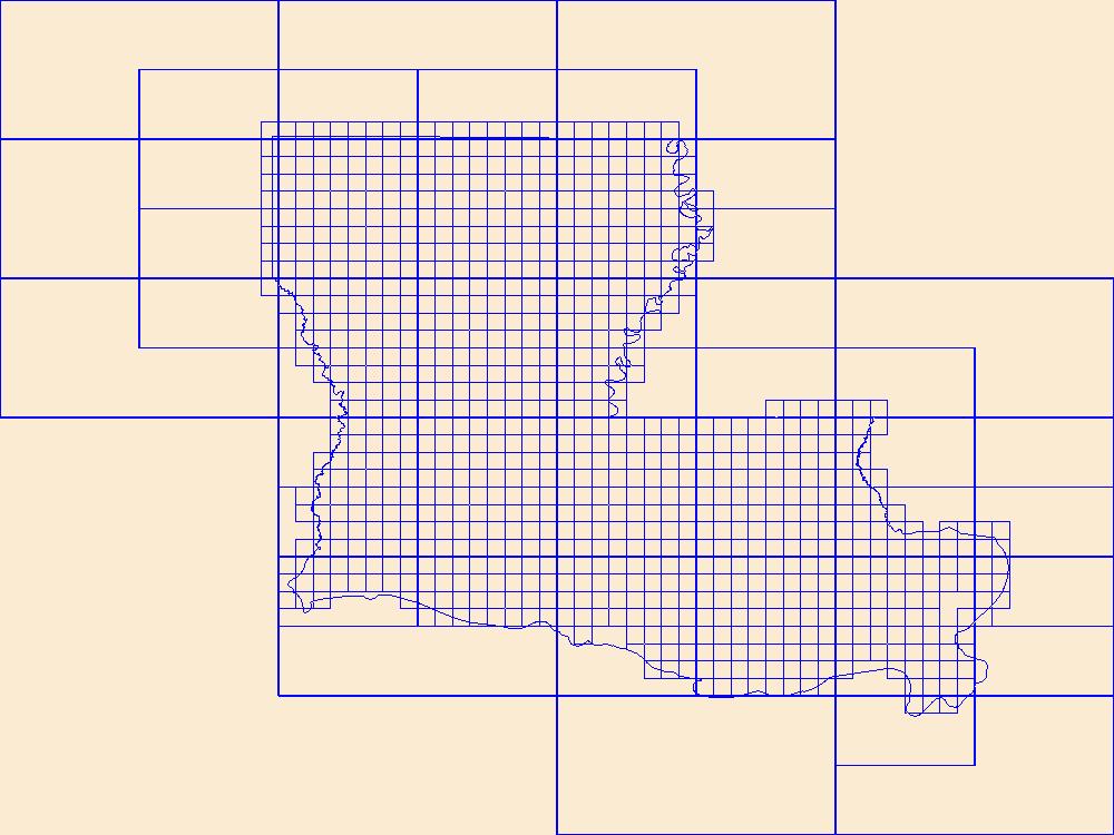
This data represents the map extent for current and historical USGS topographic maps for the United States and Territories, including 1 X 2 Degree, 1 X 1 Degree, 30 X 60 Minute, 15 X 15 Minute, 7.5 X 7.5 Minute, and 3.75 X 3.75 Minute. The grid was generated using ESRI ArcInfo GIS software.
Types: Citation;
Tags: Acadia,
Allen,
Ascension,
Assumption,
Avoyelles, All tags...
Beauregard,
Bienville,
Bossier,
Boundaries,
Caddo,
Calcasieu,
Caldwell,
Cameron,
Catahoula,
Claiborne,
Concordia,
De Soto,
Downloadable Data,
East Baton Rouge,
East Carroll,
East Feliciana,
Esri Shapefile nan,
Evangeline,
Franklin,
Grant,
Iberia,
Iberville,
Jackson,
Jefferson,
Jefferson Davis,
LA,
LaSalle,
Lafayette,
Lafourche,
Lincoln,
Livingston,
Louisiana,
Madison,
Map Indices,
Map Indices,
Map Indices,
Morehouse,
Natchitoches,
Orleans,
Ouachita,
Plaquemines,
Pointe Coupee,
Rapides,
Red River,
Richland,
Sabine,
Shapefile,
St. Bernard,
St. Charles,
St. Helena,
St. James,
St. John the Baptist,
St. Landry,
St. Martin,
St. Mary,
St. Tammany,
State,
State,
Tangipahoa,
Tensas,
Terrebonne,
US,
Union,
United States,
United States of America,
Vermilion,
Vernon,
Washington,
Webster,
West Baton Rouge,
West Carroll,
West Feliciana,
Winn,
cells,
map indices,
polygon grid, Fewer tags

The Geographic Names Information System (GNIS) is the Federal standard for geographic nomenclature. The U.S. Geological Survey developed the GNIS for the U.S. Board on Geographic Names, a Federal inter-agency body chartered by public law to maintain uniform feature name usage throughout the Government and to promulgate standard names to the public. The GNIS is the official repository of domestic geographic names data; the official vehicle for geographic names use by all departments of the Federal Government; and the source for applying geographic names to Federal electronic and printed products of all types.
Tags: Acadia,
Allen,
Antarctica,
Antarctica,
Ascension, All tags...
Assumption,
Avoyelles,
BGN,
Beauregard,
Bienville,
Board on Geographic Names,
Borough,
Bossier,
Caddo,
Calcasieu,
Caldwell,
Cameron,
Catahoula,
Census Area,
Claiborne,
Commonwealth,
Concordia,
County,
De Soto,
District,
Downloadable Data,
East Baton Rouge,
East Carroll,
East Feliciana,
Evangeline,
Feature class,
Feature coordinates,
Feature county,
Feature description,
Feature designation,
Feature history,
Feature indentification,
Feature name,
Feature state,
Franklin,
GNIS,
Geographic Names,
Geographic Names Domestic Names,
Geographic Names Information System,
Geographic feature,
Geographic name,
Geographical feature,
Geographical name,
Grant,
Iberia,
Iberville,
Jackson,
Jefferson,
Jefferson Davis,
LA,
LaSalle,
Lafayette,
Lafourche,
Lincoln,
Livingston,
Louisiana,
Madison,
Morehouse,
Municipio,
Natchitoches,
National Geographic Names Information System (GNIS),
National Geographic Names Information System (GNIS),
Official feature name,
Orleans,
Ouachita,
Outlying Area,
Parish,
Place name,
Plaquemines,
Pointe Coupee,
Populated Place,
Rapides,
Red River,
Richland,
Sabine,
St. Bernard,
St. Charles,
St. Helena,
St. James,
St. John the Baptist,
St. Landry,
St. Martin,
St. Mary,
St. Tammany,
State,
TXT (pipes),
Tangipahoa,
Tensas,
Terrebonne,
Territories,
Territory,
Topographic Map,
U.S. Board on Geographic Names,
U.S. Geological Survey,
US,
USA,
USBGN,
USGS,
UTF-8 Pipe Delimited Text File nan,
Union,
United States,
United States,
United States,
Variant name,
Vermilion,
Vernon,
Washington,
Webster,
West Baton Rouge,
West Carroll,
West Feliciana,
Winn,
antarctic,
database,
economy,
environment,
feature,
gazetteer,
geographic,
geographic names,
geographical,
geography,
geospatial,
imageryBaseMapsEarthCover,
inlandWaters,
location,
map,
name,
place,
placename,
society,
structure,
topographic map,
toponymy, Fewer tags
|
|

