Filters: Tags: BIG BEND DAM (X)
10 results (20ms)|
Filters
Date Range
Types Contacts
Tag Types Tag Schemes |
This data set contains imagery from the National Agriculture Imagery Program (NAIP). The NAIP program is administered by USDA FSA and has been established to support two main FSA strategic goals centered on agricultural production. These are increase stewardship of America's natural resources while enhancing the environment, and to ensure commodities are procured and distributed effectively and efficiently to increase food security. The NAIP program supports these goals by acquiring and providing ortho imagery that has been collected during the agricultural growing season in the U.S. The NAIP ortho imagery is tailored to meet FSA requirements and is a fundamental tool used to support FSA farm and conservation programs....
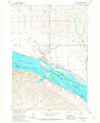
Real-time kinematic global navigation satellite system equipment was used to survey the edge of bank at selected locations on the Lake Sharpe shoreline near Lower Brule South Dakota at intervals from 2010–15. This work was completed by the U.S. Geological Survey in cooperation with the Lower Brule Sioux Tribe Environmental Protection Office.
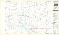
USGS Historical Quadrangle in GeoPDF.
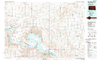
USGS Historical Quadrangle in GeoPDF.
This data set contains imagery from the National Agriculture Imagery Program (NAIP). The NAIP program is administered by USDA FSA and has been established to support two main FSA strategic goals centered on agricultural production. These are increase stewardship of America's natural resources while enhancing the environment, and to ensure commodities are procured and distributed effectively and efficiently to increase food security. The NAIP program supports these goals by acquiring and providing ortho imagery that has been collected during the agricultural growing season in the U.S. The NAIP ortho imagery is tailored to meet FSA requirements and is a fundamental tool used to support FSA farm and conservation programs....
This data set contains imagery from the National Agriculture Imagery Program (NAIP). The NAIP program is administered by USDA FSA and has been established to support two main FSA strategic goals centered on agricultural production. These are increase stewardship of America's natural resources while enhancing the environment, and to ensure commodities are procured and distributed effectively and efficiently to increase food security. The NAIP program supports these goals by acquiring and providing ortho imagery that has been collected during the agricultural growing season in the U.S. The NAIP ortho imagery is tailored to meet FSA requirements and is a fundamental tool used to support FSA farm and conservation programs....
The U.S. Geological Survey Dakota Water Science Center, in cooperation with the Lower Brule Sioux Tribe, have been collecting data to document shoreline erosion along Lake Sharpe and within the Lower Brule Reservation. This data release includes data collected and compiled from four efforts: shorelines were digitized from existing available maps and aerial imagery to record shoreline locations over time, trail cameras were used to automatically collect photos of the shoreline over time and create time-lapse videos, bank location surveys were completed at intervals to record changes in the location of the top of bank over time, and an unmanned aerial system (drone) was used to collect imagery that was used to generate...
This data set contains imagery from the National Agriculture Imagery Program (NAIP). The NAIP program is administered by USDA FSA and has been established to support two main FSA strategic goals centered on agricultural production. These are increase stewardship of America's natural resources while enhancing the environment, and to ensure commodities are procured and distributed effectively and efficiently to increase food security. The NAIP program supports these goals by acquiring and providing ortho imagery that has been collected during the agricultural growing season in the U.S. The NAIP ortho imagery is tailored to meet FSA requirements and is a fundamental tool used to support FSA farm and conservation programs....
The 1966 USGS 7.5 minute quadrangle map and aerial imagery available for the years of 1991, 2004, 2005, 2006, 2008, and 2010 was used to trace the shoreline of Lake Sharpe near Lower Brule, South Dakota. The Heads-up digitizing in ArcMap was used to trace shorelines from the 1966 quadrangle map and the aerial imagery. The resulting shoreline trace lines were saved in shapefile format. This work was completed by the U.S. Geological Survey in cooperation with the Lower Brule Sioux Tribe Environmental Protection Office.
USGS Historical Quadrangle in GeoPDF.
|

|
