Filters: Tags: BLM (X) > partyWithName: Conservation Biology Institute (X)
63 results (49ms)|
Filters
Date Range
Tag Schemes |
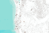
The Institute for Bird Populations (IBP) coordinates the Monitoring Avian Productivity and Survivorship (MAPS) Program to assess and monitor the vital rates and population dynamics of North American landbirds. The MAPS Program utilizes a standardized constant-effort mist netting and banding protocol (DeSante et al. 2010) at a continent-wide network of monitoring stations. Each summer dedicated volunteers operate bird-banding stations to collect data on individual "birds-in-the-hand" representing over 200 species. Analyses of MAPS data provide critical information relating to the ecology, conservation, and management of North American landbird populations and the factors responsible for changes in their populations....

This theme shows broadleaf cover for the Coast Oregon physiographic province of the Interagency Vegetation Mapping Project (IVMP). The Interagency Vegetation Mapping Project (IVMP) provides maps of existing vegetation, canopy cover, size, and cover type for the entire range of the Northern Spotted Owl using satellite imagery from the Landsat Thematic Mapper (TM). This area is commonly called the FEMAT area, in reference to the area's analysis by the Forest Ecosystem Management Assessment Team. A regression modeling approach was used to predict vegetation characteristics from this Landsat data. This process involved the use of numerous sources of ancillary data, the most crucial being USFS, BLM, and Forest Inventory...
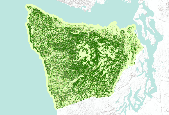
This is an aggregate dataset for the DRECP 12 km buffer region, depicting the geographic boundaries of Grazing Allotments within BLM managed public lands. An allotment is an area of land designated and managed for grazing of livestock (43 CFR 4100.0-5). An allotment may include private, state, and public lands under the jurisdiction of the Bureau of Land Management and/or other federal agencies. An allotment may be subdivided into pastures. Range improvement projects are not depicted within this dataset.
This theme shows broadleaf cover for the Coast Oregon physiographic province of the Interagency Vegetation Mapping Project (IVMP). The Interagency Vegetation Mapping Project (IVMP) provides maps of existing vegetation, canopy cover, size, and cover type for the entire range of the Northern Spotted Owl using satellite imagery from the Landsat Thematic Mapper (TM). This area is commonly called the FEMAT area, in reference to the area's analysis by the Forest Ecosystem Management Assessment Team. A regression modeling approach was used to predict vegetation characteristics from this Landsat data. This process involved the use of numerous sources of ancillary data, the most crucial being USFS, BLM, and Forest Inventory...

This theme shows broadleaf cover for the Coast Oregon physiographic province of the Interagency Vegetation Mapping Project (IVMP). The Interagency Vegetation Mapping Project (IVMP) provides maps of existing vegetation, canopy cover, size, and cover type for the entire range of the Northern Spotted Owl using satellite imagery from the Landsat Thematic Mapper (TM). This area is commonly called the FEMAT area, in reference to the area's analysis by the Forest Ecosystem Management Assessment Team. A regression modeling approach was used to predict vegetation characteristics from this Landsat data. This process involved the use of numerous sources of ancillary data, the most crucial being USFS, BLM, and Forest Inventory...

This dataset represents Elk Management Areas in Oregon compiled for the U.S Bureau of Land Management's Western Oregon Plan Revision.
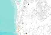
The Institute for Bird Populations (IBP) coordinates the Monitoring Avian Productivity and Survivorship (MAPS) Program to assess and monitor the vital rates and population dynamics of North American landbirds. The MAPS Program utilizes a standardized constant-effort mist netting and banding protocol (DeSante et al. 2010) at a continent-wide network of monitoring stations. Each summer dedicated volunteers operate bird-banding stations to collect data on individual "birds-in-the-hand" representing over 200 species. Analyses of MAPS data provide critical information relating to the ecology, conservation, and management of North American landbird populations and the factors responsible for changes in their populations....

This dataset represents Bureau of Land Management (BLM) grazing allotments in California. The GIS dataset obtained from the US BLM was attributed with several additional attributes derived from information publicly available on BLM web pages, in order to make information easily accessible to users. These attributes were joined to the dataset automatically, and errors of omission or commission may be present. The additional attribution was not performed under the supervision of the US BLM, and neither BLM nor CBI shall be held liable for any use or misuse of this dataset. While efforts were undertaken to ensure that features were correctly attributed using the latest publicly-available information from the BLM, users...

This map shows climate parameters and MAPSS biogeography model data for the western US from PRISM (1968-1999), and future climate projections from the regional climate model RegCM3 using ECHAM5, GENMOM, and GFDL projections as boundary conditions for 2015-2030, and 2045-2060.

The Interagency Vegetation Mapping Project (IVMP) provides maps of existing vegetation, canopy cover, size, and cover type for the entire range of the Northern Spotted Owl using satellite imagery from the Landsat Thematic Mapper (TM). This area is commonly called the FEMAT area, in reference to the area's analysis by the Forest Ecosystem Management Assessment Team. A regression modeling approach was used to predict vegetation characteristics from this Landsat data. This process involved the use of numerous sources of ancillary data, the most crucial being USFS, BLM, and Forest Inventory and Analysis (FIA) plot field data and plot photo interpreted information. This data served as training data in the regression...

The Institute for Bird Populations (IBP) coordinates the Monitoring Avian Productivity and Survivorship (MAPS) Program to assess and monitor the vital rates and population dynamics of North American landbirds. The MAPS Program utilizes a standardized constant-effort mist netting and banding protocol (DeSante et al. 2010) at a continent-wide network of monitoring stations. Each summer dedicated volunteers operate bird-banding stations to collect data on individual "birds-in-the-hand" representing over 200 species. Analyses of MAPS data provide critical information relating to the ecology, conservation, and management of North American landbird populations and the factors responsible for changes in their populations....

The Institute for Bird Populations (IBP) coordinates the Monitoring Avian Productivity and Survivorship (MAPS) Program to assess and monitor the vital rates and population dynamics of North American landbirds. The MAPS Program utilizes a standardized constant-effort mist netting and banding protocol (DeSante et al. 2010) at a continent-wide network of monitoring stations. Each summer dedicated volunteers operate bird-banding stations to collect data on individual "birds-in-the-hand" representing over 200 species. Analyses of MAPS data provide critical information relating to the ecology, conservation, and management of North American landbird populations and the factors responsible for changes in their populations....

BLM, Bakersfield, Resource Management Plan 2013

This map shows areas of high current, near-term, and long-term potential landscape development, based on factors such as urban areas, agriculture, roads, and energy development.

The Interagency Vegetation Mapping Project (IVMP) provides maps of existing vegetation, canopy cover, size, and cover type for the entire range of the Northern Spotted Owl using satellite imagery from the Landsat Thematic Mapper (TM). This area is commonly called the FEMAT area, in reference to the area's analysis by the Forest Ecosystem Management Assessment Team. A regression modeling approach was used to predict vegetation characteristics from this Landsat data. This process involved the use of numerous sources of ancillary data, the most crucial being USFS, BLM, and Forest Inventory and Analysis (FIA) plot field data and plot photo interpreted information. This data served as training data in the regression...

This dataset is an extraction from PAD-US 1.1 of BLM ACECs in the Tehachapi study area that are designated species habitat. This dataset is an extraction from PAD-US 1.1 (CBI Edition), by state.The PAD-US 1.1 (CBI Edition) data set portrays the nation's protectedareas with a standardized spatial geometry and numerous valuableattributes on land ownership, management designations, and conservationstatus (using national GAP and international IUCN coding systems). ThePAD-US 1.1 (CBI Edition) defines protected areas to include all landsdedicated to the preservation of biological diversity and to othernatural, recreation and cultural uses, and managed for these purposesthrough legal or other effective means (adapted from...
The Interagency Vegetation Mapping Project (IVMP) provides maps of existing vegetation, canopy cover, size, and cover type for the entire range of the Northern Spotted Owl using satellite imagery from the Landsat Thematic Mapper (TM). This area is commonly called the FEMAT area, in reference to the area's analysis by the Forest Ecosystem Management Assessment Team. A regression modeling approach was used to predict vegetation characteristics from this Landsat data. This process involved the use of numerous sources of ancillary data, the most crucial being USFS, BLM, and Forest Inventory and Analysis (FIA) plot field data and plot photo interpreted information. This data served as training data in the regression...

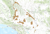
This coverage dataset represents the existing Bureau of Land Management (BLM) Areas of Critical Environmental Concern (ACEC) in California. Areas of critical environmental concern are designated by the BLM under the requirements of the Federal Land Policy and Management Act (FLPMA). This designation depicts areas where special management attention is required to prevent significant damage to important ecological and cultural resources, or due to natural hazards that require special management. Special management practices are defined for these areas through the BLM's land management planning process. Areas of critical environmental concern are nominated by individuals or organizations within or outside the BLM....

The Interagency Vegetation Mapping Project (IVMP) provides maps of existing vegetation, canopy cover, size, and cover type for the entire range of the Northern Spotted Owl using satellite imagery from the Landsat Thematic Mapper (TM). This area is commonly called the FEMAT area, in reference to the area's analysis by the Forest Ecosystem Management Assessment Team. A regression modeling approach was used to predict vegetation characteristics from this Landsat data. This process involved the use of numerous sources of ancillary data, the most crucial being USFS, BLM, and Forest Inventory and Analysis (FIA) plot field data and plot photo interpreted information. This data served as training data in the regression...

The Interagency Vegetation Mapping Project (IVMP) provides maps of existing vegetation, canopy cover, size, and cover type for the entire range of the Northern Spotted Owl using satellite imagery from the Landsat Thematic Mapper (TM). This area is commonly called the FEMAT area, in reference to the area's analysis by the Forest Ecosystem Management Assessment Team. A regression modeling approach was used to predict vegetation characteristics from this Landsat data. This process involved the use of numerous sources of ancillary data, the most crucial being USFS, BLM, and Forest Inventory and Analysis (FIA) plot field data and plot photo interpreted information. This data served as training data in the regression...
|

|
