Filters: Tags: Base Map Service (X)
15 results (35ms)|
Filters
Date Range
Types Contacts
Tag Types Tag Schemes |
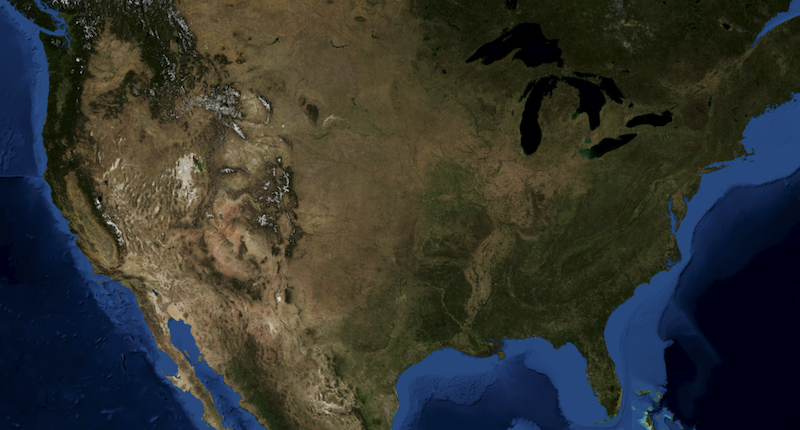
USGS Imagery Only is a tile cache base map of orthoimagery in The National Map visible to the 1:18,000 scale. Orthoimagery data are typically high resolution images that combine the visual attributes of an aerial photograph with the spatial accuracy and reliability of a planimetric map. USGS digital orthoimage resolution may vary from 6 inches to 1 meter. In the former resolution, every pixel in an orthoimage covers a six inch square of the earth's surface, while in the latter resolution, one meter square is represented by each pixel. Blue Marble: Next Generation source is displayed at small to medium scales. However, the majority of the imagery service source is from the National Agriculture Imagery Program (NAIP)...
The USGS Topo Large service from The National Map (TNM) is a dynamic topographic base map service that combines the best available data (Boundaries, Elevation, Geographic Names, Hydrography, Land Cover, Structures, Transportation, and other themes) that make up The National Map. Contours generated for the US Topo product are visible along with other data at scales of 1:13,500 and larger. This product is designed to provide a seamless view of the data in a geographic information system (GIS) accessible format, closely resembling The National Map US Topo GeoPDF product at large scales.

USGS Imagery Topo is a topographic tile cache base map with orthoimagery as a backdrop, and combines the most current data (Boundaries, Names, Transportation, Elevation, Hydrography, and other themes) that make up The National Map. Contours generated for the US Topo product are included and are visible along with other data to the 1:18,000 zoom scale. This product is designed to provide a seamless view of the data, closely resembling The National Map's US Topo (GeoPDF) product at large scales, in a GIS accessible format. Orthoimagery data are typically high resolution aerial images that combine the visual attributes of an aerial photograph with the spatial accuracy and reliability of a map. Digital orthoimage resolution...

USGS Hill Shade (or Shaded Relief) is a tile cache base map created from the National Elevation Dataset (NED), a seamless dataset of best available raster elevation data for the conterminous United States, Alaska, Hawaii, and Territorial Islands. Derived from the NED using a hill shade technique, this base map represents a continental view showing shaded relief from USGS NED layers at resolutions of 1/3-, 1-, and 2-arc-second (in Alaska only). Shaded relief (or hill shade) function parameters are: point illumination is from the NW (azimuth = 315 degrees), and altitude of the light source is 45 degrees. Color characteristics are the result of applying a color ramp in which RGB values range from white (RGB: 255, 255,...
Types: Citation;
Tags: Base Map Service,
Elevation,
Elevation Theme,
NGDA,
National Geospatial Data Asset,
The USGS Imagery Topo Large service from The National Map (TNM) is a dynamic topographic base map service that combines the best available data (Boundaries, Elevation, Geographic Names, Hydrography, Land Cover, Structures, and Transportation with Orthoimagery) that make up The National Map. Contours generated for the US Topo product are visible along with other data at scales of 1:13,500 and larger. This product is designed to provide a seamless view of the data in a geographic information system (GIS) accessible format, closely resembling The National Map US Topo GeoPDF product at large scales.
USGS Imagery Only is a tile cache base map of orthoimagery in The National Map visible to the 1:18,000 zoom scale. Orthoimagery data typically are high resolution aerial images that combine the visual attributes of an aerial photograph with the spatial accuracy and reliability of a planimetric map. USGS Digital orthoimage resolution may vary from 6 inches to 1 meter. In the former resolution, every pixel in an orthoimage covers a six inch square of the earth's surface, while in the latter resolution, one meter square is represented by each pixel. Blue Marble: Next Generation and Landsat imagery data sources are displayed at small to medium scales, however, the majority of the imagery service source is from the National...
USGS Hill Shade (or Shaded Relief) is a tile cache base map created from the National Elevation Dataset (NED), a seamless dataset of best available raster elevation data for the conterminous United States, Alaska, Hawaii, and Territorial Islands. Derived from the NED using a hill shade technique, this base map represents a continental view showing shaded relief from USGS NED layers at resolutions of 1/3-, 1-, and 2-arc-second (in Alaska only). Shaded relief (or hill shade) function parameters are: point illumination is from the NW (azimuth = 315 degrees), and altitude of the light source is 45 degrees. Color characteristics are the result of applying a color ramp in which RGB values range from white (RGB: 255, 255,...
The USGS Shaded Relief Large service from The National Map (TNM) was created from the National Elevation Dataset (NED), a seamless dataset of best available raster elevation data for the conterminous United States, Alaska, Hawaii, and Territorial Islands of the US. Derived from the NED using a hill shade technique, this base map represents a continental view showing shaded relief from USGS NED layers at resolutions of 1/3-, 1-, and 2-arc-second (in Alaska only). This hillshade is actually five separate shaded relief datasets created from the original terrain data. Each shaded relief has different azimuths and altitude values as follows: 0 45, 135 60, 270 45, 315 45, 45 45. These five datasets are then combined into...
USGS Imagery Topo is a topographic tile cache base map with orthoimagery as a backdrop, and combines the most current data (Boundaries, Names, Transportation, Elevation, Hydrography, and other themes) that make up The National Map. Contours generated for the US Topo product are included and are visible along with other data to the 1:18,000 zoom scale. This product is designed to provide a seamless view of the data, closely resembling The National Map's US Topo (GeoPDF) product at large scales, in a GIS accessible format. Orthoimagery data are typically high resolution aerial images that combine the visual attributes of an aerial photograph with the spatial accuracy and reliability of a map. Digital orthoimage resolution...
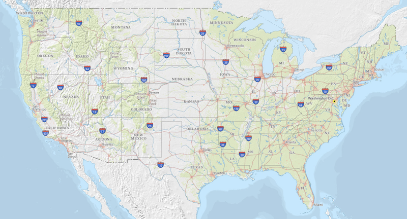
USGS Topo is a topographic tile cache base map that combines the most current data (Boundaries, Names, Transportation, Elevation, Hydrography, Land Cover, and other themes) that make up The National Map. Contours generated for the US Topo product are included and are visible along with other data to the 1:18,000 zoom scale. This product is designed to provide a seamless view of the data, closely resembling The National Map's US Topo (GeoPDF) product at large scales, in a GIS accessible format.
The National Hydrography Dataset (NHD) is a comprehensive set of digital spatial data that encodes information about naturally occurring and constructed bodies of surface water (lakes, ponds, and reservoirs), paths through which water flows (canals, ditches, streams, and rivers), and related entities such as point features (springs, wells, stream gages, and dams). The information encoded about these features includes classification and other characteristics, delineation, geographic name, position and related measures, a "reach code" through which other information can be related to the NHD, and the direction of water flow. The network of reach codes delineating water and transported material flow allows users to...
The USGS Imagery Topo Large service from The National Map (TNM) is a dynamic topographic base map service that combines the best available data (Boundaries, Elevation, Geographic Names, Hydrography, Land Cover, Structures, and Transportation with Orthoimagery) that make up The National Map. Contours generated for the US Topo product are visible along with other data at scales of 1:13,500 and larger. This product is designed to provide a seamless view of the data in a geographic information system (GIS) accessible format, closely resembling The National Map US Topo GeoPDF product at large scales.
The USGS Imagery Only Large service from The National Map (TNM) consists of National Agriculture Imagery Program (NAIP) and high resolution orthoimagery (HRO) that combine the visual attributes of an aerial photograph with the spatial accuracy and reliability of a map. Digital orthoimage resolution may vary from 6 inches to 1 meter. In the former resolution, every pixel in an orthoimage covers a six inch square of the earth’s surface, while in the latter resolution, one meter square is represented by each pixel. Many states contribute orthoimagery to The National Map, and the USGS also relies on a partnership with the U.S. Department of Agriculture's Farm Service Agency. The National Map viewer allows free downloads...

USGS Hydro-NHD is a tile cache base map that combines hydrography data in The National Map from the National Hydrography Dataset (NHD) along with the Watershed Boundary Dataset (WBD). The NHD is a comprehensive set of digital spatial data that encodes information about naturally occurring and constructed bodies of surface water (lakes, ponds, and reservoirs), paths through which water flows (canals, ditches, streams, and rivers), and related entities such as point features (springs, wells, stream gages, and dams). The information encoded about these features includes classification and other characteristics, delineation, geographic name, position and related measures, a "reach code" through which other information...
USGS Hydro-NHD is a tile cache base map that combines hydrography data in The National Map from the National Hydrography Dataset (NHD) along with the Watershed Boundary Dataset (WBD). The NHD is a comprehensive set of digital spatial data that encodes information about naturally occurring and constructed bodies of surface water (lakes, ponds, and reservoirs), paths through which water flows (canals, ditches, streams, and rivers), and related entities such as point features (springs, wells, stream gages, and dams). The information encoded about these features includes classification and other characteristics, delineation, geographic name, position and related measures, a "reach code" through which other information...
|

|
