Filters: Tags: Base-flow index (X)
12 results (20ms)|
Filters
Date Range
Types Contacts
Categories Tag Types Tag Schemes |
This 1-kilometer resolution raster (grid) dataset is an index of mean annual natural ground-water recharge. The dataset was created by multiplying a grid of base-flow index (BFI) values by a grid of mean annual runoff values derived from a 1951-80 mean annual runoff contour map. Mean annual runoff is long-term average streamflow expressed on a per-unit-area basis. The concept used to construct the dataset is based on two assumptions: (1) long-term average natural ground-water recharge is equal to long-term average natural ground-water discharge to streams, and (2) the base-flow index reasonably represents, over the long term, the percentage of natural ground-water discharge in streamflow.

These data were released prior to the October 1, 2016 effective date for the USGS’s policy dictating the review, approval, and release of scientific data as referenced in USGS Survey Manual Chapter 502.8 Fundamental Science Practices: Review and Approval of Scientific Data for Release. As part of the U.S. Geological Survey’s Groundwater Resources Program study of the Appalachian Plateaus aquifers, estimates of annual water-budget components were determined at 849 continuous-record streamflow gaging stations from Mississippi to New York. Base flow, which can serve as a proxy for annual recharge, streamflow, and runoff were estimated from computer programs—PART (Rutledge, 1993), HYSEP (Sloto and Crouse, 1996), and...

These data were released prior to the October 1, 2016 effective date for the USGS’s policy dictating the review, approval, and release of scientific data as referenced in USGS Survey Manual Chapter 502.8 Fundamental Science Practices: Review and Approval of Scientific Data for Release. This tabular data set represents the mean base-flow index expressed as a percent, compiled for every catchment of MRB_E2RF1 catchments of Major River Basins (MRBs, Crawford and others, 2006). Base flow is the component of streamflow that can be attributed to ground-water discharge into streams. The source data set is Base-Flow Index for the Conterminous United States (Wolock, 2003). The MRB_E2RF1 catchments are based on a modified...
This 1-kilometer resolution raster (grid) dataset is an index of mean annual natural ground-water recharge. The dataset was created by multiplying a grid of base-flow index (BFI) values by a grid of mean annual runoff values derived from a 1951-80 mean annual runoff contour map. Mean annual runoff is long-term average streamflow expressed on a per-unit-area basis. The concept used to construct the dataset is based on two assumptions: (1) long-term average natural ground-water recharge is equal to long-term average natural ground-water discharge to streams, and (2) the base-flow index reasonably represents, over the long term, the percentage of natural ground-water discharge in streamflow.
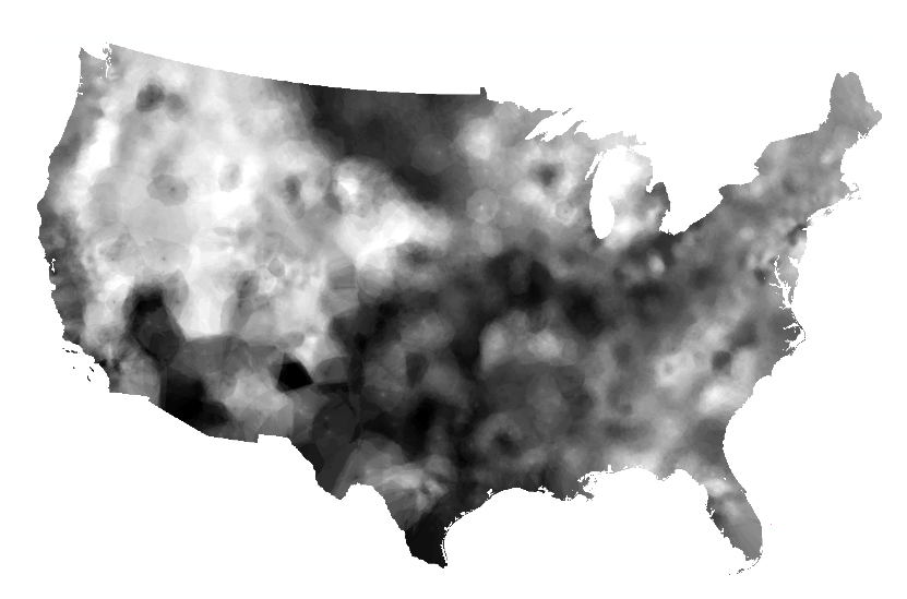
This 1-kilometer raster (grid) dataset for the conterminous United States was created by interpolating base-flow index (BFI) values estimated at U.S. Geological Survey (USGS) streamgages. Base flow is the component of streamflow that can be attributed to ground-water discharge into streams.

These data were released prior to the October 1, 2016 effective date for the USGS’s policy dictating the review, approval, and release of scientific data as referenced in USGS Survey Manual Chapter 502.8 Fundamental Science Practices: Review and Approval of Scientific Data for Release. This 1-kilometer raster (grid) dataset for the conterminous United States was created by i nterpolating base-flow index (BFI) values estimated at U.S. Geological Survey (USGS) streamgages. Base flow is the component of streamflow that can be attributed to ground-water discharge into streams.
Categories: pre-SM502.8;
Tags: Base-flow index,
Conterminous United States,
NSDI,
USGS Science Data Catalog (SDC),
environment,

These data were released prior to the October 1, 2016 effective date for the USGS’s policy dictating the review, approval, and release of scientific data as referenced in USGS Survey Manual Chapter 502.8 Fundamental Science Practices: Review and Approval of Scientific Data for Release. This 1-kilometer resolution raster (grid) dataset is an index of mean annual natural ground-water recharge. The dataset was created by multiplying a grid of base-flow index (BFI) values by a grid of mean annual runoff values derived from a 1951-80 mean annual runoff contour map. Mean annual runoff is long-term average streamflow expressed on a per-unit-area basis. The concept used to construct the dataset is based on two assumptions:...
Categories: pre-SM502.8;
Tags: Base-flow index,
Conterminous United States,
Ground-water recharge,
NSDI,
USGS Science Data Catalog (SDC),

These data were released prior to the October 1, 2016 effective date for the USGS’s policy dictating the review, approval, and release of scientific data as referenced in USGS Survey Manual Chapter 502.8 Fundamental Science Practices: Review and Approval of Scientific Data for Release. As part of the U.S. Geological Survey’s Groundwater Resources Program study of the Appalachian Plateaus aquifers, estimates of annual water-budget components were determined at 849 continuous-record streamflow gaging stations from Mississippi to New York. Base flow, which can serve as a proxy for annual recharge, streamflow, and runoff were estimated from computer programs—PART (Rutledge, 1993), HYSEP (Sloto and Crouse, 1996), and...
Categories: pre-SM502.8;
Tags: Alabama,
Appalachian Plateaus,
Appalachian Plateaus Region,
Base flow,
Base-flow index,

These data were released prior to the October 1, 2016 effective date for the USGS’s policy dictating the review, approval, and release of scientific data as referenced in USGS Survey Manual Chapter 502.8 Fundamental Science Practices: Review and Approval of Scientific Data for Release. This tabular data set represents the mean base-flow index expressed as a percent, compiled for every catchment in NHDPlus for the conterminous United States. Base flow is the component of streamflow that can be attributed to ground-water discharge into streams. The source data set is Base-Flow Index for the Conterminous United States (Wolock, 2003). The NHDPlus Version 1.1 is an integrated suite of application-ready geospatial datasets...

These data were released prior to the October 1, 2016 effective date for the USGS’s policy dictating the review, approval, and release of scientific data as referenced in USGS Survey Manual Chapter 502.8 Fundamental Science Practices: Review and Approval of Scientific Data for Release. As part of the U.S. Geological Survey’s Groundwater Resources Program study of the Appalachian Plateaus aquifers, estimates of annual water-budget components were determined at 849 continuous-record streamflow gaging stations from Mississippi to New York. Base flow, which can serve as a proxy for annual recharge, streamflow, and runoff were estimated from computer programs—PART (Rutledge, 1993), HYSEP (Sloto and Crouse, 1996), and...
Categories: pre-SM502.8;
Tags: Alabama,
Appalachian Plateaus,
Appalachian Plateaus Region,
Base flow,
Base-flow index,
|

|
