Filters: Tags: Basin boundary (X)
8 results (9ms)|
Filters
Date Range
Extensions Types Contacts
Categories Tag Types Tag Schemes |

These data were released prior to the October 1, 2016 effective date for the USGS’s policy dictating the review, approval, and release of scientific data as referenced in USGS Survey Manual Chapter 502.8 Fundamental Science Practices: Review and Approval of Scientific Data for Release. This dataset consists of drainage basin boundaries for 212 U.S. Geological Survey (USGS) stream sites sampled in the National Water-Quality Assessment (NAWQA) Program, the National Stream Quality Accounting Network (NASQAN), and the National Monitoring Network (NMN). Of the 212 sites, 206 have either a contributing or total drainage basin boundary, and the remaining 6 have both a total drainage basin boundary and a smaller contributing...

These data were released prior to the October 1, 2016 effective date for the USGS’s policy dictating the review, approval, and release of scientific data as referenced in USGS Survey Manual Chapter 502.8 Fundamental Science Practices: Review and Approval of Scientific Data for Release. This dataset and the accompanying Data Series report was created to assist in analysis and interpretation of water-quality data provided by the U.S. Geological Survey, National Stream Quality Accounting Network (NASQAN) and the National Monitoring Network (NMN). The report describes the methods used to develop the geospatial data which was primarily derived from the National Watershed Boundary Dataset (WBD12). The geospatial data...

These data were released prior to the October 1, 2016 effective date for the USGS’s policy dictating the review, approval, and release of scientific data as referenced in USGS Survey Manual Chapter 502.8 Fundamental Science Practices: Review and Approval of Scientific Data for Release. This data set consists of 204 drainage basin boundaries for U.S. Geological Survey's (USGS) stream sites sampled in the National Water Quality Assessment (NAWQA) Program and the National Stream Quality Accounting Network (NASQAN). These drainage basin boundaries are used to generate watershed characteristics for the development of water-quality models. The basin boundaries were collected from USGS hydrologists and geographers from...
Categories: pre-SM502.8;
Tags: Conterminous United States,
NASQAN,
NAWQA,
NSDI,
National Stream Quality Accounting Network,
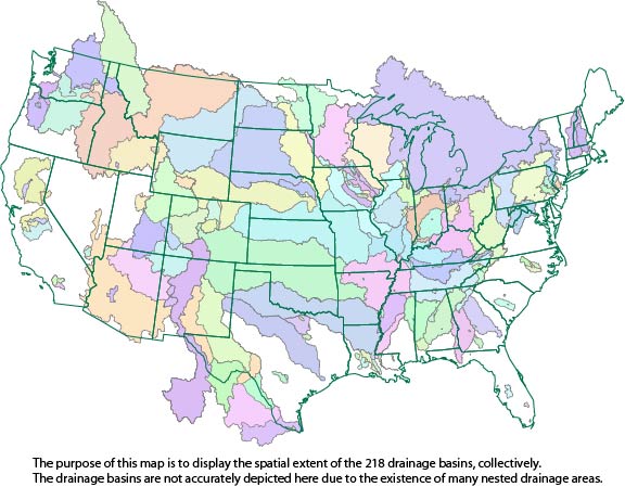
This dataset consists of drainage basin boundaries for 212 U.S. Geological Survey (USGS) stream sites sampled in the National Water-Quality Assessment (NAWQA) Program, the National Stream Quality Accounting Network (NASQAN), and the National Monitoring Network (NMN). Of the 212 sites, 206 have either a contributing or total drainage basin boundary, and the remaining 6 have both a total drainage basin boundary and a smaller contributing basin boundary. Collectively, these 218 basin boundaries have been used in a geographic information system (GIS) to generate basin characteristics for the assessment of trends in concentrations of pesticides streams of the United States.
Drainage basin areas for 376 USGS streamgages in West Virginia and adjacent states were delineated digitally. The USGS Watershed Boundary Dataset HUC12 sub-watershed lines were used as outer limits of basins, and heads-up digitizing was used to delineate boundaries from the stream gage to the HUC12 boundary. The USGS National Map was used, as background, to show both contour lines and digital elevation to highlight drainage basin divides, ridges, and valleys. Basins were delineated for (1) all active continuous-flow and crest-stage streamgages, in West Virginia, through water year 2020, (2) selected inactive streamgages, in West Virginia and adjacent states, that were used in the flood-frequency report prepared...
Categories: Data;
Types: ArcGIS REST Map Service,
ArcGIS Service Definition,
Downloadable,
Map Service,
OGC WFS Layer,
OGC WMS Layer,
OGC WMS Service;
Tags: Basin boundary,
Drainage area,
Drainage divide,
Hydrologic Unit,
Kentucky,

These data were released prior to the October 1, 2016 effective date for the USGS’s policy dictating the review, approval, and release of scientific data as referenced in USGS Survey Manual Chapter 502.8 Fundamental Science Practices: Review and Approval of Scientific Data for Release. This data set contains 204 drainage basin boundaries for U.S. Geological Survey (USGS) stream sites analyzed in the Watershed Regressions for Pesticides (WARP) model. This dataset supercedes version 1.0 released in April 2010, and consists of revisions to 26 basin boundaries.
Categories: pre-SM502.8;
Tags: Conterminous United States,
NAWQA,
NSDI,
National Water Quality Assessment,
USGS Science Data Catalog (SDC),
This ArcView shape file contains a polygon representing the extent of the Wind River coal basin boundary. This theme was created specifically for the National Coal Resources Assessment in the Northern Rocky Mountains and Great Plains Region.
This ArcView shapefile contains a polygon representation of the Green River Basin boundary. This boundary is a part of the National Coal Resource Assessment of the Northern Rocky Mountain and Great Plains Fort Union Coal Resources Assessment Area. This boundary can be shown in relation to other relevant themes in the Gren River Basin.
Categories: Data,
pre-SM502.8;
Types: Downloadable,
Map Service,
OGC WFS Layer,
OGC WMS Layer,
Shapefile;
Tags: Basin,
Basin boundary,
Basins,
Greater Green River Basin,
Greater Green River Basin,
|

|
