Filters: Tags: Blaine County (X) > Date Range: {"choice":"year"} (X)
31 results (85ms)|
Filters
Date Types (for Date Range)
Categories Tag Types Tag Schemes |

These data were released prior to the October 1, 2016 effective date for the USGS’s policy dictating the review, approval, and release of scientific data as referenced in USGS Survey Manual Chapter 502.8 Fundamental Science Practices: Review and Approval of Scientific Data for Release. Water levels in 93 wells completed in the Wood River Valley aquifer system were measured during October 22–24, 2012; these wells are part of a network established by the U.S. Geological Survey in 2006. Maps of the October 2012 water-table altitude in the unconfined aquifer and the potentiometric- surface altitude of the confined aquifer have similar topology to those on maps of October 2006 conditions. Between October 2006 and October...
These data were released prior to the October 1, 2016 effective date for the USGS’s policy dictating the review, approval, and release of scientific data as referenced in USGS Survey Manual Chapter 502.8 Fundamental Science Practices: Review and Approval of Scientific Data for Release. The entire population of the Wood River Valley depends on ground water for domestic supply, either from domestic or municipal-supply wells, rapid population growth since the 1970s has raised concerns about the continued availability of ground and surface water to support existing uses and streamflow. To help address these concerns, ground- and surface-water conditions in the area before and during the population growth that started...

A three-dimensional numerical groundwater flow model (MODFLOW-USG) was developed for the Wood River Valley (WRV) aquifer system, south-central Idaho, to evaluate groundwater and surface-water availability at the regional scale. The U.S. Geological Survey (USGS), in cooperation Idaho Department of Water Resources, used the transient groundwater flow model to simulate historical hydraulic head conditions from 1995 to 2010. This USGS data release contains all of the input and output files for the simulation described in the associated model documentation report (https://doi.org/10.3133/sir20165080).
A previously published MODFLOW-NWT groundwater-flow model for the Rush Springs aquifer in western Oklahoma (using 1 steady state stress period followed by 444 monthly stress periods representing 1979-2015; Ellis, 2018a) was used as the basis of several groundwater-use scenarios. The model is a 3-layer model including the Cloud Chief formation (confining unit of the Rush Springs aquifer), alluvial and terrace deposits, and the Rush Springs aquifer. The scenarios were used to assess the effects of increasing groundwater withdrawals from the Rush Springs aquifer on base flows to streams that flow into Fort Cobb Reservoir to address concerns over groundwater use reducing inflows to the lake. The effects of groundwater...

The High Resolution National Hydrography Dataset Plus (NHDPlus HR) is an integrated set of geospatial data layers, including the best available National Hydrography Dataset (NHD), the 10-meter 3D Elevation Program Digital Elevation Model (3DEP DEM), and the National Watershed Boundary Dataset (WBD). The NHDPlus HR combines the NHD, 3DEP DEMs, and WBD to create a stream network with linear referencing, feature naming, "value added attributes" (VAAs), elevation-derived catchments, and other features for hydrologic data analysis. The stream network with linear referencing is a system of data relationships applied to hydrographic systems so that one stream reach "flows" into another and "events" can be tied to and traced...

These data were released prior to the October 1, 2016 effective date for the USGS’s policy dictating the review, approval, and release of scientific data as referenced in USGS Survey Manual Chapter 502.8 Fundamental Science Practices: Review and Approval of Scientific Data for Release. Water levels in 93 wells completed in the Wood River Valley aquifer system were measured during October 22–24, 2012; these wells are part of a network established by the U.S. Geological Survey in 2006. Maps of the October 2012 water-table altitude in the unconfined aquifer and the potentiometric -surface altitude of the confined aquifer have similar topology to those on maps of October 2006 conditions. Between October 2006 and October...
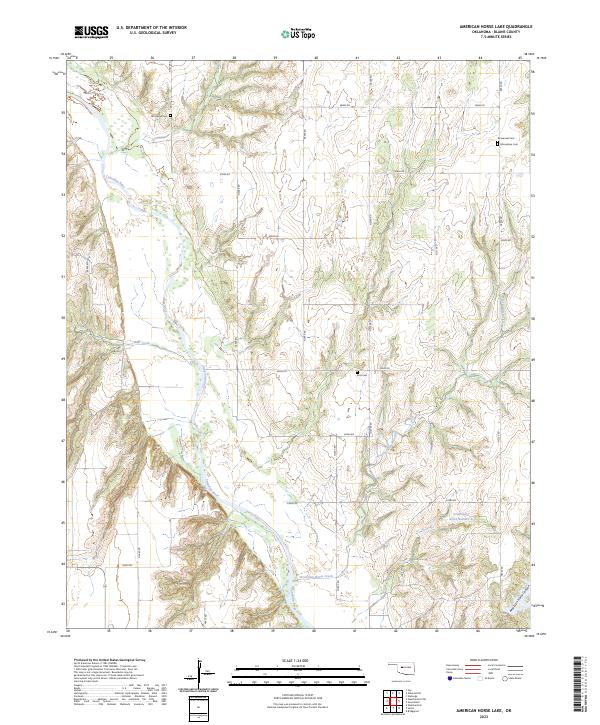
Layered geospatial PDF 7.5 Minute Quadrangle Map. Layers of geospatial data include orthoimagery, roads, grids, geographic names, elevation contours, hydrography, and other selected map features. This map is derived from GIS (geospatial information system) data. It represents a repackaging of GIS data in traditional map form, not creation of new information. The geospatial data in this map are from selected National Map data holdings and other government sources.

These data were released prior to the October 1, 2016 effective date for the USGS’s policy dictating the review, approval, and release of scientific data as referenced in USGS Survey Manual Chapter 502.8 Fundamental Science Practices: Review and Approval of Scientific Data for Release. This dataset is the estimated altitude of the top of the uppermost fine-grained sediment within the Wood River Valley aquifer system. This map was compiled by describing the estimated altitude of the top of the fine-grained sediment from about 160 well-driller reports for boreholes drilled within the area of the approximate extent of the confined aquifer. A surface was generated using kriging of the point data. This dataset was created...

The High Resolution National Hydrography Dataset Plus (NHDPlus HR) is an integrated set of geospatial data layers, including the best available National Hydrography Dataset (NHD), the 10-meter 3D Elevation Program Digital Elevation Model (3DEP DEM), and the National Watershed Boundary Dataset (WBD). The NHDPlus HR combines the NHD, 3DEP DEMs, and WBD to create a stream network with linear referencing, feature naming, "value added attributes" (VAAs), elevation-derived catchments, and other features for hydrologic data analysis. The stream network with linear referencing is a system of data relationships applied to hydrographic systems so that one stream reach "flows" into another and "events" can be tied to and traced...
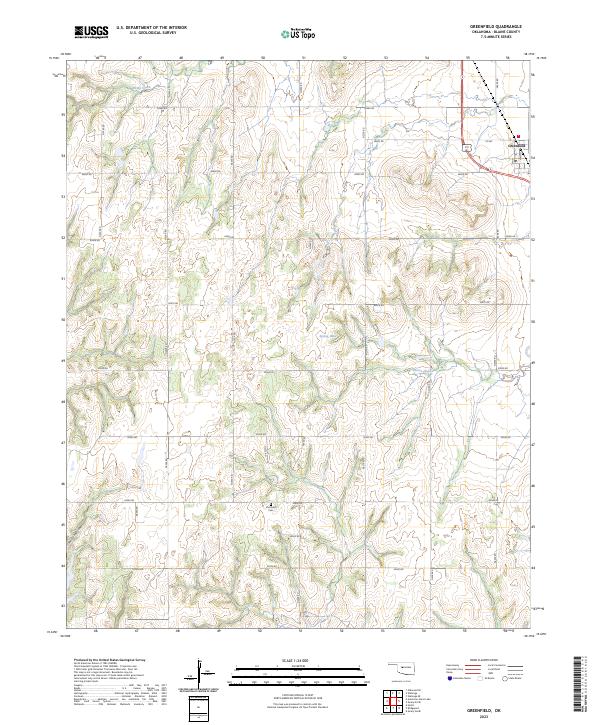
Layered geospatial PDF 7.5 Minute Quadrangle Map. Layers of geospatial data include orthoimagery, roads, grids, geographic names, elevation contours, hydrography, and other selected map features. This map is derived from GIS (geospatial information system) data. It represents a repackaging of GIS data in traditional map form, not creation of new information. The geospatial data in this map are from selected National Map data holdings and other government sources.
These data were released prior to the October 1, 2016 effective date for the USGS’s policy dictating the review, approval, and release of scientific data as referenced in USGS Survey Manual Chapter 502.8 Fundamental Science Practices: Review and Approval of Scientific Data for Release. The entire population of the Wood River Valley depends on ground water for domestic supply, either from domestic or municipal-supply wells, rapid population growth since the 1970s has raised concerns about the continued availability of ground and surface water to support existing uses and streamflow. To help address these concerns, ground- and surface-water conditions in the area before and during the population growth that started...

These data were released prior to the October 1, 2016 effective date for the USGS’s policy dictating the review, approval, and release of scientific data as referenced in USGS Survey Manual Chapter 502.8 Fundamental Science Practices: Review and Approval of Scientific Data for Release. This data set represents the extent of the Rush Springs aquifer in Oklahoma.

These data were released prior to the October 1, 2016 effective date for the USGS’s policy dictating the review, approval, and release of scientific data as referenced in USGS Survey Manual Chapter 502.8 Fundamental Science Practices: Review and Approval of Scientific Data for Release. This dataset is the estimated altitude of the consolidated rock surface underlying Quaternary sediment of the Wood River Valley aquifer system. This surface is composed of the top of pre-Quaternary bedrock and Quaternary basalt, Wood River Valley, south-central Idaho. This surface was constructed using the depth of bedrock from about 1,000 well-driller reports for boreholes and about 70 Horizontal-to-Vertical Spectral Ratio (HVSR)...
These data were released prior to the October 1, 2016 effective date for the USGS’s policy dictating the review, approval, and release of scientific data as referenced in USGS Survey Manual Chapter 502.8 Fundamental Science Practices: Review and Approval of Scientific Data for Release. The entire population of the Wood River Valley depends on ground water for domestic supply, either from domestic or municipal-supply wells, rapid population growth since the 1970s has raised concerns about the continued availability of ground and surface water to support existing uses and streamflow. To help address these concerns, ground- and surface-water conditions in the area before and during the population growth that started...
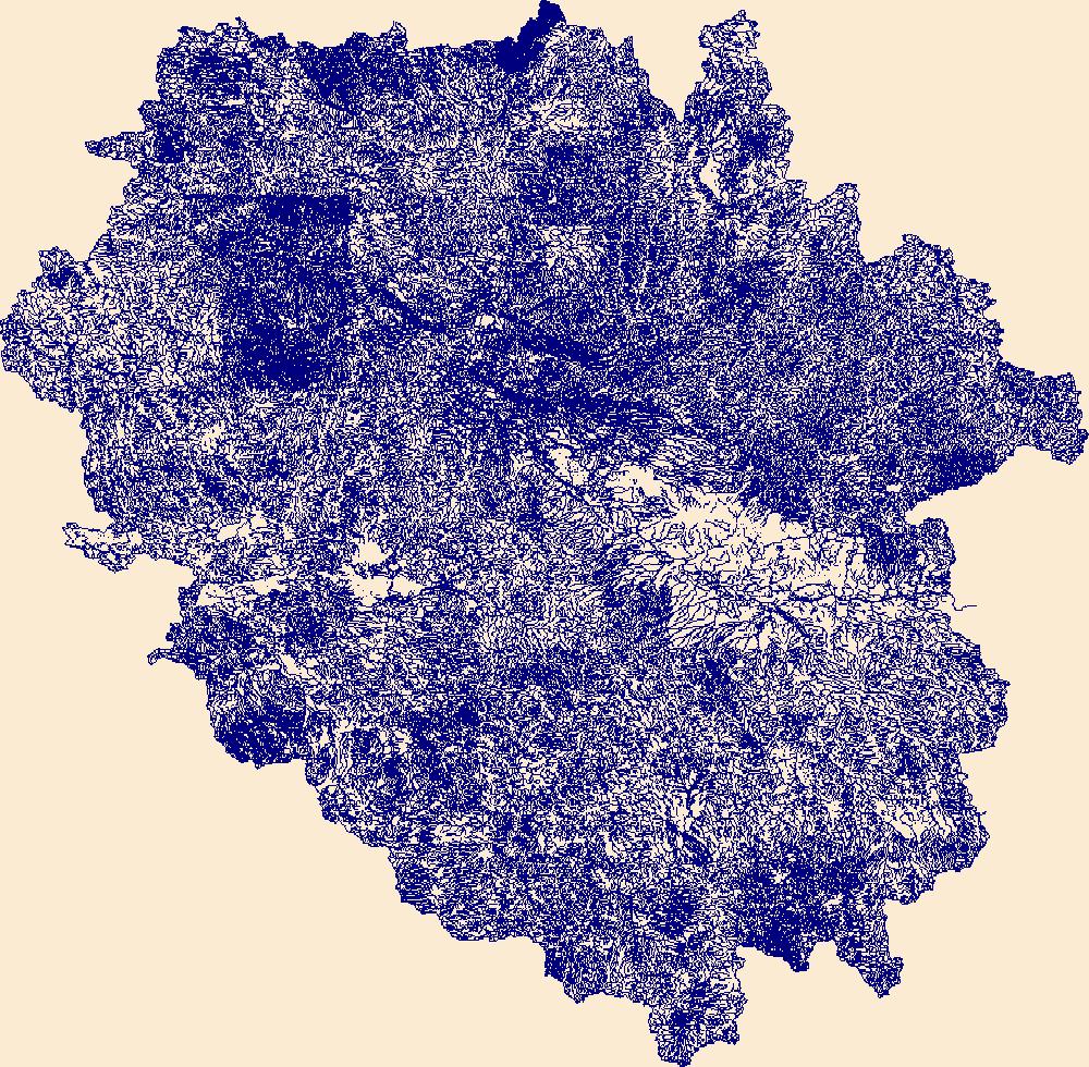
The High Resolution National Hydrography Dataset Plus (NHDPlus HR) is an integrated set of geospatial data layers, including the best available National Hydrography Dataset (NHD), the 10-meter 3D Elevation Program Digital Elevation Model (3DEP DEM), and the National Watershed Boundary Dataset (WBD). The NHDPlus HR combines the NHD, 3DEP DEMs, and WBD to create a stream network with linear referencing, feature naming, "value added attributes" (VAAs), elevation-derived catchments, and other features for hydrologic data analysis. The stream network with linear referencing is a system of data relationships applied to hydrographic systems so that one stream reach "flows" into another and "events" can be tied to and traced...
These data were released prior to the October 1, 2016 effective date for the USGS’s policy dictating the review, approval, and release of scientific data as referenced in USGS Survey Manual Chapter 502.8 Fundamental Science Practices: Review and Approval of Scientific Data for Release. The entire population of the Wood River Valley depends on ground water for domestic supply, either from domestic or municipal-supply wells, rapid population growth since the 1970s has raised concerns about the continued availability of ground and surface water to support existing uses and streamflow. To help address these concerns, ground- and surface-water conditions in the area before and during the population growth that started...
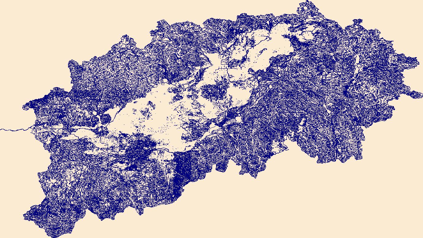
The High Resolution National Hydrography Dataset Plus (NHDPlus HR) is an integrated set of geospatial data layers, including the best available National Hydrography Dataset (NHD), the 10-meter 3D Elevation Program Digital Elevation Model (3DEP DEM), and the National Watershed Boundary Dataset (WBD). The NHDPlus HR combines the NHD, 3DEP DEMs, and WBD to create a stream network with linear referencing, feature naming, "value added attributes" (VAAs), elevation-derived catchments, and other features for hydrologic data analysis. The stream network with linear referencing is a system of data relationships applied to hydrographic systems so that one stream reach "flows" into another and "events" can be tied to and traced...

These data were released prior to the October 1, 2016 effective date for the USGS’s policy dictating the review, approval, and release of scientific data as referenced in USGS Survey Manual Chapter 502.8 Fundamental Science Practices: Review and Approval of Scientific Data for Release. This dataset is the estimated thickness of Quaternary sediment of the Wood River Valley aquifer system. This isopach map was constructed by subtracting the estimated altitude of the consolidated rock surface underlying Quaternary sediments surface (sir12-5053_BRsurf) from the altitude of land surface obtained from the 2009 1-Arc Second National Elevation Dataset as described in the "Process Step" section below. This dataset was created...

These data were released prior to the October 1, 2016 effective date for the USGS’s policy dictating the review, approval, and release of scientific data as referenced in USGS Survey Manual Chapter 502.8 Fundamental Science Practices: Review and Approval of Scientific Data for Release. Water levels in 93 wells completed in the Wood River Valley aquifer system were measured during October 22–24, 2012; these wells are part of a network established by the U.S. Geological Survey in 2006. Maps of the October 2012 water-table altitude in the unconfined aquifer and the potentiometric-surface altitude of the confined aquifer have similar topology to those on maps of October 2006 conditions. Between October 2006 and October...
These data were released prior to the October 1, 2016 effective date for the USGS’s policy dictating the review, approval, and release of scientific data as referenced in USGS Survey Manual Chapter 502.8 Fundamental Science Practices: Review and Approval of Scientific Data for Release. The entire population of the Wood River Valley depends on ground water for domestic supply, either from domestic or municipal-supply wells, rapid population growth since the 1970s has raised concerns about the continued availability of ground and surface water to support existing uses and streamflow. To help address these concerns, ground- and surface-water conditions in the area before and during the population growth that started...
|

|
