Filters: Tags: British Columbia (X)
729 results (179ms)|
Filters
Date Range
Extensions Types
Contacts
Categories Tag Types
|
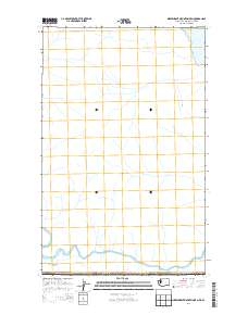
Layered geospatial PDF Map. Layers of geospatial data include orthoimagery, roads, grids, geographic names, elevation contours, hydrography, and other selected map features.
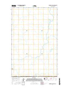
Layered geospatial PDF Map. Layers of geospatial data include orthoimagery, roads, grids, geographic names, elevation contours, hydrography, and other selected map features.
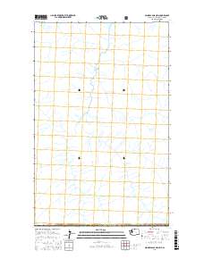
Layered geospatial PDF Map. Layers of geospatial data include orthoimagery, roads, grids, geographic names, elevation contours, hydrography, and other selected map features.
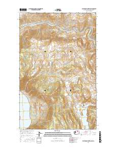
Layered GeoPDF 7.5 Minute Quadrangle Map. Layers of geospatial data include orthoimagery, roads, grids, geographic names, elevation contours, hydrography, and other selected map features.
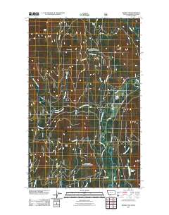
Layered GeoPDF 7.5 Minute Quadrangle Map. Layers of geospatial data include orthoimagery, roads, grids, geographic names, elevation contours, hydrography, and other selected map features.
To support the modeling of storm-induced flooding, the U.S. Geological Survey (USGS) Coastal National Elevation Database (CoNED) Applications Project has created an integrated 1-meter topobathymetric digital elevation model (TBDEM) for the Strait of Juan de Fuca, which is located at the outlet of the Salish Sea. The international boundary between Canada and the northwestern part of the United States bisects the strait. High-resolution coastal topobathymetric data is required to identify flooding, storms, and sea-level rise inundation hazard zones and other earth science applications, such as the development of sediment transport and storm surge models. The new TBDEM consists of the best available multi-source topographic...
Funding supports a multiyear initiative entitled Crown of the Continent Landscapes Analysis/Ecological Indicators Project. The work is designed to focus on issues on transboundary data integration and synthesis, habitatconnectivity analysis for grizzly bears (Ursus arctos) and other key wildlife species, and outreach programs aimed at disseminating knowledge, information products, and geospatial tools arising out of this work to the extensive network of Crown Managers Partnership (CMP) and GNLCC collaborators.FY2010Objectives:The monitoring strategy will focus on the development and acquisition of geospatial datasets from remote sensing and other GIS sources designed to track changes in habitats and human footprint...
Categories: Data,
Project;
Types: Map Service,
OGC WFS Layer,
OGC WMS Layer,
OGC WMS Service;
Tags: Alberta,
Alberta,
British Columbia,
British Columbia,
Bull Trout,
Dataset used in creating the Pacific Connectivity Map.
Categories: Data;
Tags: Alaska,
British Columbia,
California,
Data,
EARTH SCIENCE > BIOSPHERE > ECOSYSTEMS > AQUATIC ECOSYSTEMS > WETLANDS,
Location of all sagebrush species land cover obtained from the LANDFIRE (90m) Existing Vegetation Type dataset
Categories: Data;
Types: Downloadable,
GeoTIFF,
Map Service,
Raster;
Tags: Alberta,
Arizona,
Artemisia spp.,
British Columbia,
California,
Location of all sagebrush species land cover obtained from the LANDFIRE (90m) Existing Vegetation Type dataset
Categories: Data;
Types: Downloadable,
GeoTIFF,
Map Service,
Raster;
Tags: Alberta,
Arizona,
Artemisia spp.,
British Columbia,
California,
Regulatory processes associated with development of major mining operations in Alaska and British columbia were evaluated using specific case studies. Included were one hard rock mine in Alaska (Red Dog Mine), one hard rock mine in British Columbia (Snip Mine), and one offshore gold dredging project in Alaska (WestGold BIMA). Based on a comparison of the three case studies, it became clear that the primary incentives for cost effective permitting are: 1) early and continuing coordination of proposed project plans, designs and schedules with key regulatory agencies and local area residents and 2) development of a sufficient level of baseline information on air quality, water quality, wetlands, endangered species,...
Types: Map Service,
OGC WFS Layer,
OGC WMS Layer,
OGC WMS Service;
Tags: Alaska (AK),
British Columbia
Background: Yellow-cedar (Callitropsis nootkatensis) is an economically and culturally important tree of the North Pacific coastal rainforest, ranging from northern California through Southeast Alaska. The species has been in decline for many decades, particularly in the northern portion of its range (Southeast Alaska and coastal British Columbia), and is currently under consideration for listing as Threatened or Endangered. Previous work has delineated locations of yellow-cedar stands across the species range, and modeled geophysical features associated with presence of the tree.Purpose: The purpose of this project is to support refinement of a range-wide analysis of bioclimatic factors that support healthy vs....
Categories: Data,
Project;
Types: Map Service,
OGC WFS Layer,
OGC WMS Layer,
OGC WMS Service;
Tags: AK-1,
Academics & scientific researchers,
Alaska,
BIOSPHERICINDICATORS,
British Columbia,
The National Hydrography Dataset (NHD) is a feature-based database that interconnects and uniquely identifies the stream segments or reaches that make up the nation's surface water drainage system. NHD data was originally developed at 1:100,000-scale and exists at that scale for the whole country. This high-resolution NHD, generally developed at 1:24,000/1:12,000 scale, adds detail to the original 1:100,000-scale NHD. (Data for Alaska, Puerto Rico and the Virgin Islands was developed at high-resolution, not 1:100,000 scale.) Local resolution NHD is being developed where partners and data exist. The NHD contains reach codes for networked features, flow direction, names, and centerline representations for areal water...
This proposal is to deliver the pilot component of a wetland tracking project initiated by the CIJV in 2010. The wetland trend project will deliver an assessment of wetland trends and develop an approach for tracking wetland trends into the future; this will have relevance to conservation planning throughout transboundary ecological planning units, including Bird Conservation Regions (BCRs) 9 and 10, and the Cold Deserts and Western Cordillera Ecoregions (Figure 2). The project is currently in a scoping stage, wherein high-level approaches are being developed for wetland tracking in 2-3 regional priority areas of the CIJV. Delivery of the pilot projects will support wider implementation of the tracking project as...
Categories: Data,
Project;
Types: Map Service,
OGC WFS Layer,
OGC WMS Layer,
OGC WMS Service;
Tags: Alberta,
BCR 10,
BCR 9,
British Columbia,
CA-1,
This .zip file contains four products that will allow users to recreate the analyses and spatial data figures used in Sergeant et al. 2020, A classification of streamflow patterns across the coastal Gulf of Alaska: 1) Autoclass input and output files (provided as folders with multiple simple text files), 2) Classification data (.csv file) for individual watersheds, including Fundamental Daily Streamflow Statistics, landcover variables, and class membership, 3) Esri map package (.mpk file) that will allow users to recreate Figures 3 and 5 using ArcGIS and extract basic watershed-scale data such as watershed ID, drainage area, primary class assignment, and primary class membership probability (for users interested...
This project is part of an ongoing effort to develop and implement a landscape level decision support system (DSS) across the boundaries of Idaho, Washington, Oregon, and Montana. The project will strengthen public understanding in the use of objective and scientific fish and wildlife data and predictive modeling for purposes of developing geospatially-based landscape science to inform conservation and development actions. The project will inform, educate, and garner public and user support of the DSS upon its public release, aid in the development and use of the DSS web interface based on customer input and preferences, and provide communications strategies, tools, messages, forums, and feedback for improving public...
Categories: Data,
Project;
Types: Map Service,
OGC WFS Layer,
OGC WMS Layer,
OGC WMS Service;
Tags: British Columbia,
CA-1,
CA-2,
CA-2,
CA-2,
Workshop goals were to gather a diverse group of researchers and management professionals to focus on three objectives: Sharing current information regarding the effects of climate change on aquatic ecosystems Presenting analysis tools that could assist managers in addressing climate change Discussing management implications of climate change, the utility of existing tools, and future information & analysis needs
Categories: Data,
Project;
Types: Map Service,
OGC WFS Layer,
OGC WMS Layer,
OGC WMS Service;
Tags: Academics & scientific researchers,
Alberta,
Aquatic Connectivity,
British Columbia,
Bull Trout,
Conclusions: Presents environmental indicators for the purpose of guiding future planning efforts. These include 16 key indicators incorporating 64 separate measures highlighting the status and trends in environmental issues, as well targets to guide planning efforts. Thresholds/Learnings: Road density thresholds: Grizzly Bear 0.4km/km2; Black Bear 1.25km/km2; Elk 0.62 km/km2; and Bull Trout 0.1-1.31 km/km2 Synopsis: This document represents British Columbia’s third environmental indicators report, including 16 key indicators incorporating 64 separate measures highlighting the status and trends in environmental issues. The information is grouped into six theme areas: biodiversity, water, stewardship, human health...
Categories: Publication;
Types: Citation,
Map Service,
OGC WFS Layer,
OGC WMS Layer,
OGC WMS Service;
Tags: British Columbia,
Climate change,
Land use configuration,
Landscape fragmentation,
Natural cover amount,
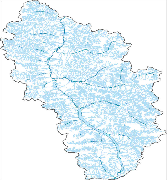
Flow network arcs (observed, inferred and constructed). Contains no banks, coast or watershed bourdary arcs. Directionalized and connected. Contains heirarchial key and route identifier. Data prepared as a part of the BC Freshwater Atlas.
Types: Map Service,
OGC WFS Layer,
OGC WMS Layer,
OGC WMS Service;
Tags: BC,
British Columbia,
CWB ,
Canada,
Corporate Watershed Base,
All manmade waterbodies, including reservoirs and canals, for the province, prepared as a part of the BC Freshwater Atlas.
Types: Map Service,
OGC WFS Layer,
OGC WMS Layer,
OGC WMS Service;
Tags: BC,
British Columbia,
CWB ,
Canada,
Corporate Watershed Base,
|

|
