Filters
Date Range
Contacts
Tag Types
Tag Schemes
|
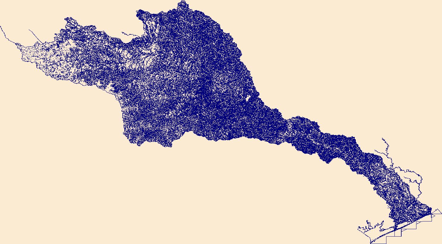
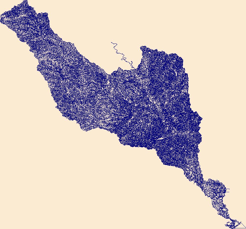
The High Resolution National Hydrography Dataset Plus (NHDPlus HR) is an integrated set of geospatial data layers, including the best available National Hydrography Dataset (NHD), the 10-meter 3D Elevation Program Digital Elevation Model (3DEP DEM), and the National Watershed Boundary Dataset (WBD). The NHDPlus HR combines the NHD, 3DEP DEMs, and WBD to create a stream network with linear referencing, feature naming, "value added attributes" (VAAs), elevation-derived catchments, and other features for hydrologic data analysis. The stream network with linear referencing is a system of data relationships applied to hydrographic systems so that one stream reach "flows" into another and "events" can be tied to and traced...
Tags: Austin County,
Bastrop County,
Blanco County,
Brazoria County,
Brown County, All tags...
Burnet County,
Caldwell County,
Callahan County,
Coke County,
Coleman County,
Colorado County,
Comanche County,
Concho County,
Crockett County,
Downloadable Data,
Eastland County,
Edwards County,
Fayette County,
FileGDB,
FileGDB 10.1,
Fort Bend County,
Gillespie County,
Glasscock County,
HU-4 Subregion,
HU-4 Subregion,
HU4_1209,
Hays County,
Howard County,
Hydrography,
Irion County,
Kendall County,
Kerr County,
Kimble County,
Lampasas County,
Lee County,
Llano County,
Mason County,
Matagorda County,
McCulloch County,
Menard County,
Midland County,
Mills County,
NHDPlus HR Rasters,
NHDPlus High Resolution (NHDPlus HR),
National Hydrography Dataset (NHD),
National Hydrography Dataset Plus High Resolution (NHDPlus HR),
National Hydrography Dataset Plus High Resolution (NHDPlus HR) Current,
Nolan County,
Reagan County,
Real County,
Runnels County,
San Saba County,
Schleicher County,
Sterling County,
Sutton County,
TX,
Taylor County,
Texas,
Tom Green County,
Travis County,
US,
United States,
Upton County,
Washington County,
Wharton County,
Williamson County,
base maps,
cartography,
catchments,
channels,
digital elevation models,
drainage basins,
earth sciences,
elevation,
environment,
geographic information systems,
geoscientific,
geospatial analysis,
hydrographic datasets,
hydrographic features,
hydrology,
imagery,
inland waters,
lakes,
land surface characteristics,
reservoirs,
river reaches,
rivers,
streamflow,
streamflow data,
streams,
topography,
water bodies,
water quality,
water resources,
watersheds, Fewer tags

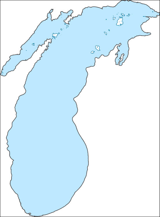
The High Resolution National Hydrography Dataset Plus (NHDPlus HR) is an integrated set of geospatial data layers, including the best available National Hydrography Dataset (NHD), the 10-meter 3D Elevation Program Digital Elevation Model (3DEP DEM), and the National Watershed Boundary Dataset (WBD). The NHDPlus HR combines the NHD, 3DEP DEMs, and WBD to create a stream network with linear referencing, feature naming, "value added attributes" (VAAs), elevation-derived catchments, and other features for hydrologic data analysis. The stream network with linear referencing is a system of data relationships applied to hydrographic systems so that one stream reach "flows" into another and "events" can be tied to and traced...
Tags: Adams County,
Alger County,
Baraga County,
Brown County,
Calumet County, All tags...
Columbia County,
Delta County,
Dickinson County,
Dodge County,
Door County,
Downloadable Data,
FileGDB,
FileGDB 10.1,
Florence County,
Fond du Lac County,
Forest County,
Gogebic County,
Green Lake County,
HU-4 Subregion,
HU-4 Subregion,
HU4_0403,
Hydrography,
Iron County,
Kewaunee County,
Langlade County,
Luce County,
MI,
Mackinac County,
Manitowoc County,
Marathon County,
Marinette County,
Marquette County,
Marquette County,
Menominee County,
Menominee County,
Michigan,
NHDPlus HR Rasters,
NHDPlus High Resolution (NHDPlus HR),
National Hydrography Dataset (NHD),
National Hydrography Dataset Plus High Resolution (NHDPlus HR),
National Hydrography Dataset Plus High Resolution (NHDPlus HR) Current,
Oconto County,
Oneida County,
Outagamie County,
Ozaukee County,
Portage County,
Schoolcraft County,
Shawano County,
Sheboygan County,
US,
United States,
Vilas County,
WI,
Waupaca County,
Waushara County,
Winnebago County,
Wisconsin,
base maps,
cartography,
catchments,
channels,
digital elevation models,
drainage basins,
earth sciences,
elevation,
environment,
geographic information systems,
geoscientific,
geospatial analysis,
hydrographic datasets,
hydrographic features,
hydrology,
imagery,
inland waters,
lakes,
land surface characteristics,
reservoirs,
river reaches,
rivers,
streamflow,
streamflow data,
streams,
topography,
water bodies,
water quality,
water resources,
watersheds, Fewer tags

The High Resolution National Hydrography Dataset Plus (NHDPlus HR) is an integrated set of geospatial data layers, including the best available National Hydrography Dataset (NHD), the 10-meter 3D Elevation Program Digital Elevation Model (3DEP DEM), and the National Watershed Boundary Dataset (WBD). The NHDPlus HR combines the NHD, 3DEP DEMs, and WBD to create a stream network with linear referencing, feature naming, "value added attributes" (VAAs), elevation-derived catchments, and other features for hydrologic data analysis. The stream network with linear referencing is a system of data relationships applied to hydrographic systems so that one stream reach "flows" into another and "events" can be tied to and traced...
Tags: Adams County,
Athens County,
Boone County,
Boyd County,
Bracken County, All tags...
Brown County,
Butler County,
Cabell County,
Campbell County,
Carroll County,
Carter County,
Clark County,
Clermont County,
Clinton County,
Dearborn County,
Decatur County,
Downloadable Data,
Elliott County,
Fayette County,
FileGDB,
FileGDB 10.1,
Fleming County,
Franklin County,
Gallatin County,
Gallia County,
Grant County,
Greene County,
Greenup County,
HU-4 Subregion,
HU-4 Subregion,
HU4_0509,
Hamilton County,
Highland County,
Hocking County,
Hydrography,
IN,
Indiana,
Jackson County,
KY,
Kenton County,
Kentucky,
Lawrence County,
Lawrence County,
Lewis County,
Lincoln County,
Logan County,
Madison County,
Mason County,
Mason County,
Meigs County,
Mingo County,
Montgomery County,
Morgan County,
NHDPlus HR Rasters,
NHDPlus High Resolution (NHDPlus HR),
National Hydrography Dataset (NHD),
National Hydrography Dataset Plus High Resolution (NHDPlus HR),
National Hydrography Dataset Plus High Resolution (NHDPlus HR) Current,
OH,
Ohio,
Ohio County,
Pendleton County,
Pike County,
Putnam County,
Ripley County,
Ross County,
Rowan County,
Scioto County,
Switzerland County,
US,
United States,
Vinton County,
WV,
Warren County,
Wayne County,
West Virginia,
base maps,
cartography,
catchments,
channels,
digital elevation models,
drainage basins,
earth sciences,
elevation,
environment,
geographic information systems,
geoscientific,
geospatial analysis,
hydrographic datasets,
hydrographic features,
hydrology,
imagery,
inland waters,
lakes,
land surface characteristics,
reservoirs,
river reaches,
rivers,
streamflow,
streamflow data,
streams,
topography,
water bodies,
water quality,
water resources,
watersheds, Fewer tags
The High Resolution National Hydrography Dataset Plus (NHDPlus HR) is an integrated set of geospatial data layers, including the best available National Hydrography Dataset (NHD), the 10-meter 3D Elevation Program Digital Elevation Model (3DEP DEM), and the National Watershed Boundary Dataset (WBD). The NHDPlus HR combines the NHD, 3DEP DEMs, and WBD to create a stream network with linear referencing, feature naming, "value added attributes" (VAAs), elevation-derived catchments, and other features for hydrologic data analysis. The stream network with linear referencing is a system of data relationships applied to hydrographic systems so that one stream reach "flows" into another and "events" can be tied to and traced...
Tags: Austin County,
Bastrop County,
Bell County,
Brazoria County,
Brazos County, All tags...
Brown County,
Burleson County,
Burnet County,
Callahan County,
Comanche County,
Coryell County,
Downloadable Data,
Eastland County,
Erath County,
Falls County,
Fayette County,
FileGDB,
FileGDB 10.1,
Fort Bend County,
Freestone County,
Grimes County,
HU-4 Subregion,
HU-4 Subregion,
HU4_1207,
Hamilton County,
Harris County,
Hill County,
Hydrography,
Lampasas County,
Lee County,
Leon County,
Limestone County,
Madison County,
McLennan County,
Milam County,
Mills County,
NHDPlus HR Rasters,
NHDPlus High Resolution (NHDPlus HR),
National Hydrography Dataset (NHD),
National Hydrography Dataset Plus High Resolution (NHDPlus HR),
National Hydrography Dataset Plus High Resolution (NHDPlus HR) Current,
Robertson County,
Stephens County,
TX,
Texas,
Travis County,
US,
United States,
Waller County,
Washington County,
Williamson County,
base maps,
cartography,
catchments,
channels,
digital elevation models,
drainage basins,
earth sciences,
elevation,
environment,
geographic information systems,
geoscientific,
geospatial analysis,
hydrographic datasets,
hydrographic features,
hydrology,
imagery,
inland waters,
lakes,
land surface characteristics,
reservoirs,
river reaches,
rivers,
streamflow,
streamflow data,
streams,
topography,
water bodies,
water quality,
water resources,
watersheds, Fewer tags
The High Resolution National Hydrography Dataset Plus (NHDPlus HR) is an integrated set of geospatial data layers, including the best available National Hydrography Dataset (NHD), the 10-meter 3D Elevation Program Digital Elevation Model (3DEP DEM), and the National Watershed Boundary Dataset (WBD). The NHDPlus HR combines the NHD, 3DEP DEMs, and WBD to create a stream network with linear referencing, feature naming, "value added attributes" (VAAs), elevation-derived catchments, and other features for hydrologic data analysis. The stream network with linear referencing is a system of data relationships applied to hydrographic systems so that one stream reach "flows" into another and "events" can be tied to and traced...
Tags: Allegan County,
Antrim County,
Benzie County,
Berrien County,
Brown County, All tags...
Charlevoix County,
Cheboygan County,
Cook County,
Delta County,
Door County,
Downloadable Data,
Emmet County,
FileGDB,
FileGDB 10.1,
Grand Traverse County,
HU-4 Subregion,
HU-4 Subregion,
HU4_0419i,
Hydrography,
IL,
IN,
Illinois,
Indiana,
Kenosha County,
Kewaunee County,
LaPorte County,
Lake County,
Lake County,
Leelanau County,
MI,
Mackinac County,
Manistee County,
Manitowoc County,
Marinette County,
Mason County,
Menominee County,
Michigan,
Milwaukee County,
Muskegon County,
NHDPlus HR Rasters,
NHDPlus High Resolution (NHDPlus HR),
National Hydrography Dataset (NHD),
National Hydrography Dataset Plus High Resolution (NHDPlus HR),
National Hydrography Dataset Plus High Resolution (NHDPlus HR) Current,
Oceana County,
Oconto County,
Ottawa County,
Ozaukee County,
Porter County,
Racine County,
Schoolcraft County,
Sheboygan County,
US,
United States,
Van Buren County,
WI,
Wisconsin,
base maps,
cartography,
catchments,
channels,
digital elevation models,
drainage basins,
earth sciences,
elevation,
environment,
geographic information systems,
geoscientific,
geospatial analysis,
hydrographic datasets,
hydrographic features,
hydrology,
imagery,
inland waters,
lakes,
land surface characteristics,
reservoirs,
river reaches,
rivers,
streamflow,
streamflow data,
streams,
topography,
water bodies,
water quality,
water resources,
watersheds, Fewer tags

The High Resolution National Hydrography Dataset Plus (NHDPlus HR) is an integrated set of geospatial data layers, including the best available National Hydrography Dataset (NHD), the 10-meter 3D Elevation Program Digital Elevation Model (3DEP DEM), and the National Watershed Boundary Dataset (WBD). The NHDPlus HR combines the NHD, 3DEP DEMs, and WBD to create a stream network with linear referencing, feature naming, "value added attributes" (VAAs), elevation-derived catchments, and other features for hydrologic data analysis. The stream network with linear referencing is a system of data relationships applied to hydrographic systems so that one stream reach "flows" into another and "events" can be tied to and traced...
Tags: Adams County,
Brown County,
Bureau County,
Calhoun County,
Cass County, All tags...
Champaign County,
Christian County,
De Witt County,
Downloadable Data,
FileGDB,
FileGDB 10.1,
Ford County,
Fulton County,
Greene County,
HU-4 Subregion,
HU-4 Subregion,
HU4_0713,
Hancock County,
Henderson County,
Henry County,
Hydrography,
IL,
Illinois,
Iroquois County,
Jersey County,
Knox County,
LaSalle County,
Lee County,
Livingston County,
Logan County,
Macon County,
Macoupin County,
Marshall County,
Mason County,
McDonough County,
McLean County,
Menard County,
Montgomery County,
Morgan County,
Moultrie County,
NHDPlus HR Rasters,
NHDPlus High Resolution (NHDPlus HR),
National Hydrography Dataset (NHD),
National Hydrography Dataset Plus High Resolution (NHDPlus HR),
National Hydrography Dataset Plus High Resolution (NHDPlus HR) Current,
Peoria County,
Piatt County,
Pike County,
Putnam County,
Sangamon County,
Schuyler County,
Scott County,
Shelby County,
Stark County,
Tazewell County,
US,
United States,
Warren County,
Woodford County,
base maps,
cartography,
catchments,
channels,
digital elevation models,
drainage basins,
earth sciences,
elevation,
environment,
geographic information systems,
geoscientific,
geospatial analysis,
hydrographic datasets,
hydrographic features,
hydrology,
imagery,
inland waters,
lakes,
land surface characteristics,
reservoirs,
river reaches,
rivers,
streamflow,
streamflow data,
streams,
topography,
water bodies,
water quality,
water resources,
watersheds, Fewer tags

The High Resolution National Hydrography Dataset Plus (NHDPlus HR) is an integrated set of geospatial data layers, including the best available National Hydrography Dataset (NHD), the 10-meter 3D Elevation Program Digital Elevation Model (3DEP DEM), and the National Watershed Boundary Dataset (WBD). The NHDPlus HR combines the NHD, 3DEP DEMs, and WBD to create a stream network with linear referencing, feature naming, "value added attributes" (VAAs), elevation-derived catchments, and other features for hydrologic data analysis. The stream network with linear referencing is a system of data relationships applied to hydrographic systems so that one stream reach "flows" into another and "events" can be tied to and traced...
Tags: Adams County,
Allen County,
Auglaize County,
Bartholomew County,
Benton County, All tags...
Blackford County,
Boone County,
Brown County,
Carroll County,
Cass County,
Champaign County,
Clark County,
Clark County,
Clay County,
Clay County,
Clinton County,
Coles County,
Crawford County,
Crawford County,
Cumberland County,
Darke County,
Daviess County,
Decatur County,
Delaware County,
Douglas County,
Downloadable Data,
Dubois County,
Edgar County,
Edwards County,
Effingham County,
Fayette County,
Fayette County,
FileGDB,
FileGDB 10.1,
Ford County,
Fountain County,
Fulton County,
Gallatin County,
Gibson County,
Grant County,
Greene County,
HU-4 Subregion,
HU-4 Subregion,
HU4_0512,
Hamilton County,
Hamilton County,
Hancock County,
Hendricks County,
Henry County,
Howard County,
Huntington County,
Hydrography,
IL,
IN,
Illinois,
Indiana,
Iroquois County,
Jackson County,
Jasper County,
Jasper County,
Jay County,
Jefferson County,
Jefferson County,
Jennings County,
Johnson County,
Knox County,
Kosciusko County,
Lawrence County,
Lawrence County,
Livingston County,
Madison County,
Marion County,
Marion County,
Marshall County,
Martin County,
Mercer County,
Miami County,
Monroe County,
Montgomery County,
Morgan County,
Moultrie County,
NHDPlus HR Rasters,
NHDPlus High Resolution (NHDPlus HR),
National Hydrography Dataset (NHD),
National Hydrography Dataset Plus High Resolution (NHDPlus HR),
National Hydrography Dataset Plus High Resolution (NHDPlus HR) Current,
Noble County,
OH,
Ohio,
Orange County,
Owen County,
Parke County,
Pike County,
Posey County,
Pulaski County,
Putnam County,
Randolph County,
Richland County,
Ripley County,
Rush County,
Scott County,
Shelby County,
Shelby County,
Spencer County,
Starke County,
Sullivan County,
Tippecanoe County,
Tipton County,
US,
United States,
Vanderburgh County,
Vermilion County,
Vermillion County,
Vigo County,
Wabash County,
Wabash County,
Warren County,
Warrick County,
Washington County,
Wayne County,
Wells County,
White County,
White County,
Whitley County,
base maps,
cartography,
catchments,
channels,
digital elevation models,
drainage basins,
earth sciences,
elevation,
environment,
geographic information systems,
geoscientific,
geospatial analysis,
hydrographic datasets,
hydrographic features,
hydrology,
imagery,
inland waters,
lakes,
land surface characteristics,
reservoirs,
river reaches,
rivers,
streamflow,
streamflow data,
streams,
topography,
water bodies,
water quality,
water resources,
watersheds, Fewer tags

The High Resolution National Hydrography Dataset Plus (NHDPlus HR) is an integrated set of geospatial data layers, including the best available National Hydrography Dataset (NHD), the 10-meter 3D Elevation Program Digital Elevation Model (3DEP DEM), and the National Watershed Boundary Dataset (WBD). The NHDPlus HR combines the NHD, 3DEP DEMs, and WBD to create a stream network with linear referencing, feature naming, "value added attributes" (VAAs), elevation-derived catchments, and other features for hydrologic data analysis. The stream network with linear referencing is a system of data relationships applied to hydrographic systems so that one stream reach "flows" into another and "events" can be tied to and traced...
Tags: Allegan County,
Antrim County,
Benzie County,
Berrien County,
Brown County, All tags...
Charlevoix County,
Cheboygan County,
Cook County,
Delta County,
Door County,
Downloadable Data,
Emmet County,
FileGDB,
FileGDB 10.1,
Grand Traverse County,
HU-4 Subregion,
HU-4 Subregion,
HU4_0419,
Hydrography,
IL,
IN,
Illinois,
Indiana,
Kenosha County,
Kewaunee County,
LaPorte County,
Lake County,
Lake County,
Leelanau County,
MI,
Mackinac County,
Manistee County,
Manitowoc County,
Marinette County,
Mason County,
Menominee County,
Michigan,
Milwaukee County,
Muskegon County,
NHDPlus HR Rasters,
NHDPlus High Resolution (NHDPlus HR),
National Hydrography Dataset (NHD),
National Hydrography Dataset Plus High Resolution (NHDPlus HR),
National Hydrography Dataset Plus High Resolution (NHDPlus HR) Current,
Oceana County,
Oconto County,
Ottawa County,
Ozaukee County,
Porter County,
Racine County,
Schoolcraft County,
Sheboygan County,
US,
United States,
Van Buren County,
WI,
Wisconsin,
base maps,
cartography,
catchments,
channels,
digital elevation models,
drainage basins,
earth sciences,
elevation,
environment,
geographic information systems,
geoscientific,
geospatial analysis,
hydrographic datasets,
hydrographic features,
hydrology,
imagery,
inland waters,
lakes,
land surface characteristics,
reservoirs,
river reaches,
rivers,
streamflow,
streamflow data,
streams,
topography,
water bodies,
water quality,
water resources,
watersheds, Fewer tags
|
|

