Filters: Tags: Buda (X)
26 results (56ms)|
Filters
Date Range
Types Contacts
Categories Tag Types Tag Schemes |
This data set contains imagery from the National Agriculture Imagery Program (NAIP). The NAIP program is administered by USDA FSA and has been established to support two main FSA strategic goals centered on agricultural production. These are increase stewardship of America's natural resources while enhancing the environment, and to ensure commodities are procured and distributed effectively and efficiently to increase food security. The NAIP program supports these goals by acquiring and providing ortho imagery that has been collected during the agricultural growing season in the U.S. The NAIP ortho imagery is tailored to meet FSA requirements and is a fundamental tool used to support FSA farm and conservation programs....
This data set contains imagery from the National Agriculture Imagery Program (NAIP). The NAIP program is administered by USDA FSA and has been established to support two main FSA strategic goals centered on agricultural production. These are increase stewardship of America's natural resources while enhancing the environment, and to ensure commodities are procured and distributed effectively and efficiently to increase food security. The NAIP program supports these goals by acquiring and providing ortho imagery that has been collected during the agricultural growing season in the U.S. The NAIP ortho imagery is tailored to meet FSA requirements and is a fundamental tool used to support FSA farm and conservation programs....
This data set contains imagery from the National Agriculture Imagery Program (NAIP). The NAIP program is administered by USDA FSA and has been established to support two main FSA strategic goals centered on agricultural production. These are, increase stewardship of America's natural resources while enhancing the environment, and to ensure commodities are procured and distributed effectively and efficiently to increase food security. The NAIP program supports these goals by acquiring and providing ortho imagery that has been collected during the agricultural growing season in the U.S. The NAIP ortho imagery is tailored to meet FSA requirements and is a fundamental tool used to support FSA farm and conservation programs....
Core Research Center, cutting HH01881, from well operated by PIONEER NATURAL RESOURCESRaw Properties from download, web scrape, MapServer, and Macrostrat API{"Lib Num": "HH01881", "API Num": "4201334323", "Operator": "PIONEER NATURAL RESOURCES", "Well Name": "EDMUND TOM 02 01 PILOT", "Field": "EAGLEVILLE", "State": "TX", "County": "ATASCOSA", "Thin Sec": "F", "Analysis": "F", "Latitude": "28.72015", "Longitude": "-98.2812", "coordinates_geohash": "9v457s3g4018", "Source": "PROVIDED BY DONOR", "Min": "900", "Max": "10690", "Security Flag": "NO SPECIAL RESTRICTIONS", "crc_collection_name": "cutting", "sb_parent_id": "4f4e49d8e4b07f02db5df2d2", "intervals": [{"Formation": "NAVARRO", "Age": "CRETACEOUS", "Min Depth":...
Core Research Center, cutting HH01883, from well operated by PIONEER NATURAL RESOURCESRaw Properties from download, web scrape, MapServer, and Macrostrat API{"Lib Num": "HH01883", "API Num": "4201334322", "Operator": "PIONEER NATURAL RESOURCES", "Well Name": "EDMUND TOM 01 01 P/H", "Field": "EAGLEVILLE", "State": "TX", "County": "ATASCOSA", "Thin Sec": "F", "Analysis": "F", "Latitude": "28.696978", "Longitude": "-98.295219", "coordinates_geohash": "9v4570ps52km", "Source": "PROVIDED BY DONOR", "Min": "10000", "Max": "15620", "Security Flag": "NO SPECIAL RESTRICTIONS", "crc_collection_name": "cutting", "sb_parent_id": "4f4e49d8e4b07f02db5df2d2", "intervals": [{"Formation": "GEORGETOWN", "Age": "CRETACEOUS", "Min...
This data set contains imagery from the National Agriculture Imagery Program (NAIP). The NAIP program is administered by USDA FSA and has been established to support two main FSA strategic goals centered on agricultural production. These are, increase stewardship of America's natural resources while enhancing the environment, and to ensure commodities are procured and distributed effectively and efficiently to increase food security. The NAIP program supports these goals by acquiring and providing ortho imagery that has been collected during the agricultural growing season in the U.S. The NAIP ortho imagery is tailored to meet FSA requirements and is a fundamental tool used to support FSA farm and conservation programs....
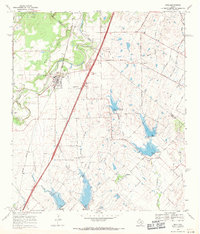
USGS Historical Quadrangle in GeoPDF.
This data set contains imagery from the National Agriculture Imagery Program (NAIP). The NAIP program is administered by USDA FSA and has been established to support two main FSA strategic goals centered on agricultural production. These are increase stewardship of America's natural resources while enhancing the environment, and to ensure commodities are procured and distributed effectively and efficiently to increase food security. The NAIP program supports these goals by acquiring and providing ortho imagery that has been collected during the agricultural growing season in the U.S. The NAIP ortho imagery is tailored to meet FSA requirements and is a fundamental tool used to support FSA farm and conservation programs....
USGS Historical Quadrangle in GeoPDF.
USGS Historical Quadrangle in GeoPDF.
Core Research Center, core T268, from well operated by U S BORAXRaw Properties from download, web scrape, MapServer, and Macrostrat API{"Lib Num": "T268", "API Num": null, "Operator": "U S BORAX", "Well Name": "13-1", "Field": "IRON MOUNTAIN PROJECT", "State": "TX", "County": "CULBERSON", "Type": "FULL", "Photos": "F", "Thin Sec": "F", "Analysis": "F", "Latitude": null, "Longitude": null, "Source": null, "Security Flag": "NO SPECIAL RESTRICTIONS", "crc_collection_name": "core", "sb_parent_id": "4f4e49dae4b07f02db5e0486", "intervals": [{"Formation": "BUDA", "Age": "CRET", "Min Depth": "26", "Max Depth": "2268"}, {"Formation": "SALADO", "Age": "PERM", "Min Depth": "26", "Max Depth": "2268"}], "crcwc_url": "https://my.usgs.gov/crcwc/core/report/14269"}
This data set contains imagery from the National Agriculture Imagery Program (NAIP). The NAIP program is administered by USDA FSA and has been established to support two main FSA strategic goals centered on agricultural production. These are, increase stewardship of America's natural resources while enhancing the environment, and to ensure commodities are procured and distributed effectively and efficiently to increase food security. The NAIP program supports these goals by acquiring and providing ortho imagery that has been collected during the agricultural growing season in the U.S. The NAIP ortho imagery is tailored to meet FSA requirements and is a fundamental tool used to support FSA farm and conservation programs....
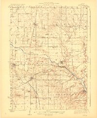
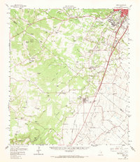
USGS Historical Quadrangle in GeoPDF.
Core Research Center, cutting HH01918, from well operated by SUNDANCE ENERGYRaw Properties from download, web scrape, MapServer, and Macrostrat API{"Lib Num": "HH01918", "API Num": "4231136653", "Operator": "SUNDANCE ENERGY", "Well Name": "WOODWARD EFS 4HB", "Field": "EAGLEVILLE", "State": "TX", "County": "LIVE OAK", "Thin Sec": "F", "Analysis": "F", "Latitude": "28.45576", "Longitude": "-98.37957", "coordinates_geohash": "9v41ck4nvf5s", "Source": "PROVIDED BY DONOR", "Min": "5870", "Max": "20402", "Security Flag": "NO SPECIAL RESTRICTIONS", "crc_collection_name": "cutting", "sb_parent_id": "4f4e49d8e4b07f02db5df2d2", "intervals": [{"Formation": "EAGLE FORD", "Age": "CRETACEOUS", "Min Depth": "16670", "Max Depth":...
Core Research Center, cutting HH01941, from well operated by PIONEER NATURAL RESOURCESRaw Properties from download, web scrape, MapServer, and Macrostrat API{"Lib Num": "HH01941", "API Num": "4229734958", "Operator": "PIONEER NATURAL RESOURCES", "Well Name": "H HARLAN BETHUNE 01 01 PILOT", "Field": "EAGLEVILLE", "State": "TX", "County": "LIVE OAK", "Thin Sec": "F", "Analysis": "F", "Latitude": "28.6056", "Longitude": "-98.26323", "coordinates_geohash": "9v44ezqzsy34", "Source": "PROVIDED BY DONOR", "Min": "1200", "Max": "12070", "Security Flag": "NO SPECIAL RESTRICTIONS", "crc_collection_name": "cutting", "sb_parent_id": "4f4e49d8e4b07f02db5df2d2", "intervals": [{"Formation": "GEORGETOWN", "Age": "CRETACEOUS", "Min...
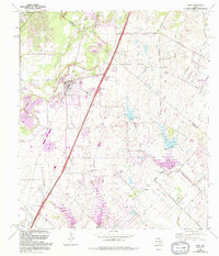
USGS Historical Quadrangle in GeoPDF.
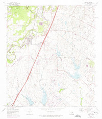
USGS Historical Quadrangle in GeoPDF.
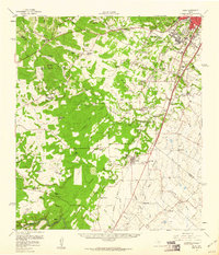
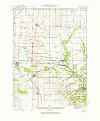
USGS Historical Quadrangle in GeoPDF.
This data set contains imagery from the National Agriculture Imagery Program (NAIP). The NAIP program is administered by USDA FSA and has been established to support two main FSA strategic goals centered on agricultural production. These are, increase stewardship of America's natural resources while enhancing the environment, and to ensure commodities are procured and distributed effectively and efficiently to increase food security. The NAIP program supports these goals by acquiring and providing ortho imagery that has been collected during the agricultural growing season in the U.S. The NAIP ortho imagery is tailored to meet FSA requirements and is a fundamental tool used to support FSA farm and conservation programs....
The Texas Water Development Board classifies the karstic Edwards and Trinity aquifers as major sources of water in south-central Texas. To effectively manage the water resources in the area, detailed maps and descriptions of the geologic framework and hydrostratigraphic units of the aquifers outcropping in Hays County, Tex. are needed. In 2016 and 2018, the U.S. Geological Survey, in cooperation with the Edwards Aquifer Authority, mapped the geologic framework and hydrostratigraphy of the Edwards and Trinity aquifers within Hays County, Tex. at 1:24,000 scale. These digital data accompany Clark, A.K., Pedraza, D.E., and Morris, R.R., 2018, Geologic framework and hydrostratigraphy of the Edwards and Trinity aquifers...
Types: Map Service,
OGC WFS Layer,
OGC WMS Layer,
OGC WMS Service;
Tags: Austin Group,
Balcones fault zone,
Barton Creek,
Blanco River,
Buda,
|

|
