Filters
Date Range
Types
Contacts
Tag Types
Tag Schemes
|
This data set contains imagery from the National Agriculture Imagery Program (NAIP). The NAIP program is administered by USDA FSA and has been established to support two main FSA strategic goals centered on agricultural production. These are increase stewardship of America's natural resources while enhancing the environment, and to ensure commodities are procured and distributed effectively and efficiently to increase food security. The NAIP program supports these goals by acquiring and providing ortho imagery that has been collected during the agricultural growing season in the U.S. The NAIP ortho imagery is tailored to meet FSA requirements and is a fundamental tool used to support FSA farm and conservation programs....
Types: Citation;
Tags: 29151,
3.75 x 3.75 minute,
3809135,
Aerial Compliance,
COOPER HILL, All tags...
COOPER HILL, NW,
Compliance,
Digital Ortho rectified Image,
Downloadable Data,
JPEG 2000,
JPEG2000,
MO,
MO151,
NAIP,
OSAGE CO MO FSA,
Ortho Rectification,
Orthoimagery,
Osage,
Quarter Quadrangle,
USDA National Agriculture Imagery Program (NAIP),
farming,
imageryBaseMapsEarthCover, Fewer tags

The Leadville North 7.5' quadrangle lies at the northern end of the Upper Arkansas Valley, where the Continental Divide at Tennessee Pass creates a low drainage divide between the Colorado and Arkansas River watersheds. In the eastern half of the quadrangle, the Paleozoic sedimentary section dips generally 20–30 degrees east. At Tennessee Pass and Missouri Hill, the core of the Sawatch anticlinorium is mapped as displaying a tight hanging-wall syncline and foot-wall anticline within the basement-cored structure. High-angle, west-dipping, Neogene normal faults cut the eastern margin of the broad, Sawatch anticlinorium. Minor displacements along high-angle, east- and west-dipping Laramide reverse faults occurred in...
Tags: 10Be, 26Al,
Belden Formation,
Buckeye Peak,
Bull Lake glaciation,
Camp Hale, All tags...
Chaffee Group,
Chicago Ridge,
Colorado,
Colorado River,
Cooper Hill,
Dotsero Formation,
Eagle County,
Eagle River,
East Fork Arkansas River,
Geomorphology,
Gray porphyry group,
Hornblende Latite Porphyry,
Lake County,
Laramide,
Leadville,
Leadville Limestone,
Leadville Quadrangle,
Lincoln Porphyry,
Manitou Dolomite,
Minturn Formation,
Missouri Hill,
Mosquito Range,
Mount Zion,
No Name Gulch,
Pinedale Glaciation,
Rio Grande rift,
Sawatch Quartzite,
Sawatch Range,
Sawatch anticlinorium,
South Park,
St. Kevin Granite,
Structural Geology,
Tennessee Creek,
Tennessee Park,
Tennessee Pass,
Turquoise Lake,
USA,
USGS Science Data Catalog (SDC),
United States,
Upper Arkansas River,
Upper Arkansas Valley,
White Porphyry Group,
cosmogenic nuclide,
neotectonics,
pre-Bull Lake glaciation, Fewer tags
This data set contains imagery from the National Agriculture Imagery Program (NAIP). The NAIP program is administered by USDA FSA and has been established to support two main FSA strategic goals centered on agricultural production. These are increase stewardship of America's natural resources while enhancing the environment, and to ensure commodities are procured and distributed effectively and efficiently to increase food security. The NAIP program supports these goals by acquiring and providing ortho imagery that has been collected during the agricultural growing season in the U.S. The NAIP ortho imagery is tailored to meet FSA requirements and is a fundamental tool used to support FSA farm and conservation programs....
Types: Citation;
Tags: 29151,
3.75 x 3.75 minute,
3809135,
Aerial Compliance,
COOPER HILL, All tags...
COOPER HILL, SW,
Compliance,
Digital Ortho rectified Image,
Downloadable Data,
JPEG 2000,
JPEG2000,
MO,
MO151,
NAIP,
OSAGE CO MO FSA,
Ortho Rectification,
Orthoimagery,
Osage,
Quarter Quadrangle,
USDA National Agriculture Imagery Program (NAIP),
farming,
imageryBaseMapsEarthCover, Fewer tags
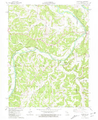
USGS Historical Quadrangle in GeoPDF.
Tags: 7.5 x 7.5 minute,
Cooper Hill,
Downloadable Data,
GeoPDF,
GeoTIFF, All tags...
Historical Topographic Maps,
Historical Topographic Maps 7.5 x 7.5 Minute Map Series,
MO,
Map,
imageryBaseMapsEarthCover, Fewer tags
This data set contains imagery from the National Agriculture Imagery Program (NAIP). The NAIP program is administered by USDA FSA and has been established to support two main FSA strategic goals centered on agricultural production. These are increase stewardship of America's natural resources while enhancing the environment, and to ensure commodities are procured and distributed effectively and efficiently to increase food security. The NAIP program supports these goals by acquiring and providing ortho imagery that has been collected during the agricultural growing season in the U.S. The NAIP ortho imagery is tailored to meet FSA requirements and is a fundamental tool used to support FSA farm and conservation programs....
Types: Citation;
Tags: 29151,
3.75 x 3.75 minute,
3809135,
Aerial Compliance,
COOPER HILL, All tags...
COOPER HILL, SE,
Compliance,
Digital Ortho rectified Image,
Downloadable Data,
JPEG 2000,
JPEG2000,
MO,
MO151,
NAIP,
OSAGE CO MO FSA,
Ortho Rectification,
Orthoimagery,
Osage,
Quarter Quadrangle,
USDA National Agriculture Imagery Program (NAIP),
farming,
imageryBaseMapsEarthCover, Fewer tags
This data set contains imagery from the National Agriculture Imagery Program (NAIP). The NAIP program is administered by USDA FSA and has been established to support two main FSA strategic goals centered on agricultural production. These are increase stewardship of America's natural resources while enhancing the environment, and to ensure commodities are procured and distributed effectively and efficiently to increase food security. The NAIP program supports these goals by acquiring and providing ortho imagery that has been collected during the agricultural growing season in the U.S. The NAIP ortho imagery is tailored to meet FSA requirements and is a fundamental tool used to support FSA farm and conservation programs....
Types: Citation;
Tags: 29151,
3.75 x 3.75 minute,
3809135,
Aerial Compliance,
COOPER HILL, All tags...
COOPER HILL, NE,
Compliance,
Digital Ortho rectified Image,
Downloadable Data,
JPEG 2000,
JPEG2000,
MO,
MO151,
NAIP,
OSAGE CO MO FSA,
Ortho Rectification,
Orthoimagery,
Osage,
Quarter Quadrangle,
USDA National Agriculture Imagery Program (NAIP),
farming,
imageryBaseMapsEarthCover, Fewer tags
|
|

