Filters
Contacts
(Less)
-
U.S. Geological Survey, National Geospatial Technical Operations Center
-
U.S. Geological Survey
-
U.S. Geological Survey - CERSC Data Management Services Project
-
Central Energy Resources Science Center
-
Energy and Minerals
-
U. S. Geological Survey, Central Energy Resources Team
-
U.S. Geological Survey - ScienceBase
-
United States Geological Survey
-
Condon, S.M
-
Dyman, T.S
-
Jennifer C Brennan
-
Coleman, James L
-
Dubiel, Russell F
-
GS ScienceBase
-
Hackley, Paul C
-
Hayba, Daniel O
-
Karlsen, A.W
-
Pearson, Ofori N
-
Pitman, Janet K
-
Swanson, Sharon M
-
Warwick, Peter D
-
Columbia Environmental Research Center
-
U.S. Geological Survey
-
U.S. Geological Survey - ScienceBase
-
CERC Data Managers
-
Ecosystems
-
U. S. Geological Survey, Energy Resources Science Center
|

This data represents the map extent for current and historical USGS topographic maps for the United States and Territories, including 1 X 2 Degree, 1 X 1 Degree, 30 X 60 Minute, 15 X 15 Minute, 7.5 X 7.5 Minute, and 3.75 X 3.75 Minute. The grid was generated using ESRI ArcInfo GIS software.
Tags: Adjuntas,
Aguada,
Aguadilla,
Aguas Buenas,
Aibonito, All tags...
Arecibo,
Arroyo,
Añasco,
Barceloneta,
Barranquitas,
Bayamón,
Boundaries,
Cabo Rojo,
Caguas,
Camuy,
Canóvanas,
Carolina,
Cataño,
Cayey,
Ceiba,
Ciales,
Cidra,
Coamo,
Comerío,
Corozal,
Culebra,
Dorado,
Downloadable Data,
Esri File GeoDatabase 10,
Fajardo,
FileGDB,
Florida,
Guayama,
Guayanilla,
Guaynabo,
Gurabo,
Guánica,
Hatillo,
Hormigueros,
Humacao,
Isabela,
Jayuya,
Juana Díaz,
Juncos,
Lajas,
Lares,
Las Marías,
Las Piedras,
Loíza,
Luquillo,
Manatí,
Map Indices,
Map Indices,
Map Indices,
Maricao,
Maunabo,
Mayagüez,
Moca,
Morovis,
Naguabo,
Naranjito,
Orocovis,
PR,
Patillas,
Peñuelas,
Ponce,
Puerto Rico,
Quebradillas,
Rincón,
Río Grande,
Sabana Grande,
Salinas,
San Germán,
San Juan,
San Lorenzo,
San Sebastián,
Santa Isabel,
State,
State,
Toa Alta,
Toa Baja,
Trujillo Alto,
US,
United States,
United States of America,
Utuado,
Vega Alta,
Vega Baja,
Vieques,
Villalba,
Yabucoa,
Yauco,
cells,
map indices,
polygon grid, Fewer tags
This data represents the map extent for current and historical USGS topographic maps for the United States and Territories, including 1 X 2 Degree, 1 X 1 Degree, 30 X 60 Minute, 15 X 15 Minute, 7.5 X 7.5 Minute, and 3.75 X 3.75 Minute. The grid was generated using ESRI ArcInfo GIS software.
Tags: Boundaries,
Downloadable Data,
Esri File GeoDatabase 10,
FileGDB,
GU, All tags...
Guam,
Guam,
Map Indices,
Map Indices,
Map Indices,
State,
State,
US,
United States,
United States of America,
cells,
map indices,
polygon grid, Fewer tags
This data represents the map extent for current and historical USGS topographic maps for the United States and Territories, including 1 X 2 Degree, 1 X 1 Degree, 30 X 60 Minute, 15 X 15 Minute, 7.5 X 7.5 Minute, and 3.75 X 3.75 Minute. The grid was generated using ESRI ArcInfo GIS software.
Tags: Boundaries,
Carson City,
Churchill,
Clark,
Douglas, All tags...
Downloadable Data,
Elko,
Esmeralda,
Esri File GeoDatabase 10,
Eureka,
FileGDB,
Humboldt,
Lander,
Lincoln,
Lyon,
Map Indices,
Map Indices,
Map Indices,
Mineral,
NV,
Nevada,
Nye,
Pershing,
State,
State,
Storey,
US,
United States,
United States of America,
Washoe,
White Pine,
cells,
map indices,
polygon grid, Fewer tags
This data represents the map extent for current and historical USGS topographic maps for the United States and Territories, including 1 X 2 Degree, 1 X 1 Degree, 30 X 60 Minute, 15 X 15 Minute, 7.5 X 7.5 Minute, and 3.75 X 3.75 Minute. The grid was generated using ESRI ArcInfo GIS software.
Tags: Allen,
Anderson,
Atchison,
Barber,
Barton, All tags...
Boundaries,
Bourbon,
Brown,
Butler,
Chase,
Chautauqua,
Cherokee,
Cheyenne,
Clark,
Clay,
Cloud,
Coffey,
Comanche,
Cowley,
Crawford,
Decatur,
Dickinson,
Doniphan,
Douglas,
Downloadable Data,
Edwards,
Elk,
Ellis,
Ellsworth,
Esri File GeoDatabase 10,
FileGDB,
Finney,
Ford,
Franklin,
Geary,
Gove,
Graham,
Grant,
Gray,
Greeley,
Greenwood,
Hamilton,
Harper,
Harvey,
Haskell,
Hodgeman,
Jackson,
Jefferson,
Jewell,
Johnson,
KS,
Kansas,
Kearny,
Kingman,
Kiowa,
Labette,
Lane,
Leavenworth,
Lincoln,
Linn,
Logan,
Lyon,
Map Indices,
Map Indices,
Map Indices,
Marion,
Marshall,
McPherson,
Meade,
Miami,
Mitchell,
Montgomery,
Morris,
Morton,
Nemaha,
Neosho,
Ness,
Norton,
Osage,
Osborne,
Ottawa,
Pawnee,
Phillips,
Pottawatomie,
Pratt,
Rawlins,
Reno,
Republic,
Rice,
Riley,
Rooks,
Rush,
Russell,
Saline,
Scott,
Sedgwick,
Seward,
Shawnee,
Sheridan,
Sherman,
Smith,
Stafford,
Stanton,
State,
State,
Stevens,
Sumner,
Thomas,
Trego,
US,
United States,
United States of America,
Wabaunsee,
Wallace,
Washington,
Wichita,
Wilson,
Woodson,
Wyandotte,
cells,
map indices,
polygon grid, Fewer tags
This data represents the map extent for current and historical USGS topographic maps for the United States and Territories, including 1 X 2 Degree, 1 X 1 Degree, 30 X 60 Minute, 15 X 15 Minute, 7.5 X 7.5 Minute, and 3.75 X 3.75 Minute. The grid was generated using ESRI ArcInfo GIS software.
Tags: Adams,
Alcorn,
Amite,
Attala,
Benton, All tags...
Bolivar,
Boundaries,
Calhoun,
Carroll,
Chickasaw,
Choctaw,
Claiborne,
Clarke,
Clay,
Coahoma,
Copiah,
Covington,
DeSoto,
Downloadable Data,
Esri File GeoDatabase 10,
FileGDB,
Forrest,
Franklin,
George,
Greene,
Grenada,
Hancock,
Harrison,
Hinds,
Holmes,
Humphreys,
Issaquena,
Itawamba,
Jackson,
Jasper,
Jefferson,
Jefferson Davis,
Jones,
Kemper,
Lafayette,
Lamar,
Lauderdale,
Lawrence,
Leake,
Lee,
Leflore,
Lincoln,
Lowndes,
MS,
Madison,
Map Indices,
Map Indices,
Map Indices,
Marion,
Marshall,
Mississippi,
Monroe,
Montgomery,
Neshoba,
Newton,
Noxubee,
Oktibbeha,
Panola,
Pearl River,
Perry,
Pike,
Pontotoc,
Prentiss,
Quitman,
Rankin,
Scott,
Sharkey,
Simpson,
Smith,
State,
State,
Stone,
Sunflower,
Tallahatchie,
Tate,
Tippah,
Tishomingo,
Tunica,
US,
Union,
United States,
United States of America,
Walthall,
Warren,
Washington,
Wayne,
Webster,
Wilkinson,
Winston,
Yalobusha,
Yazoo,
cells,
map indices,
polygon grid, Fewer tags

This data represents the map extent for current and historical USGS topographic maps for the United States and Territories, including 1 X 2 Degree, 1 X 1 Degree, 30 X 60 Minute, 15 X 15 Minute, 7.5 X 7.5 Minute, and 3.75 X 3.75 Minute. The grid was generated using ESRI ArcInfo GIS software.
Types: Citation;
Tags: Adams,
Ashland,
Barron,
Bayfield,
Boundaries, All tags...
Brown,
Buffalo,
Burnett,
Calumet,
Chippewa,
Clark,
Columbia,
Crawford,
Dane,
Dodge,
Door,
Douglas,
Downloadable Data,
Dunn,
Eau Claire,
Esri Shapefile nan,
Florence,
Fond du Lac,
Forest,
Grant,
Green,
Green Lake,
Iowa,
Iron,
Jackson,
Jefferson,
Juneau,
Kenosha,
Kewaunee,
La Crosse,
Lafayette,
Langlade,
Lincoln,
Manitowoc,
Map Indices,
Map Indices,
Map Indices,
Marathon,
Marinette,
Marquette,
Menominee,
Milwaukee,
Monroe,
Oconto,
Oneida,
Outagamie,
Ozaukee,
Pepin,
Pierce,
Polk,
Portage,
Price,
Racine,
Richland,
Rock,
Rusk,
Sauk,
Sawyer,
Shapefile,
Shawano,
Sheboygan,
St. Croix,
State,
State,
Taylor,
Trempealeau,
US,
United States,
United States of America,
Vernon,
Vilas,
WI,
Walworth,
Washburn,
Washington,
Waukesha,
Waupaca,
Waushara,
Winnebago,
Wisconsin,
Wood,
cells,
map indices,
polygon grid, Fewer tags
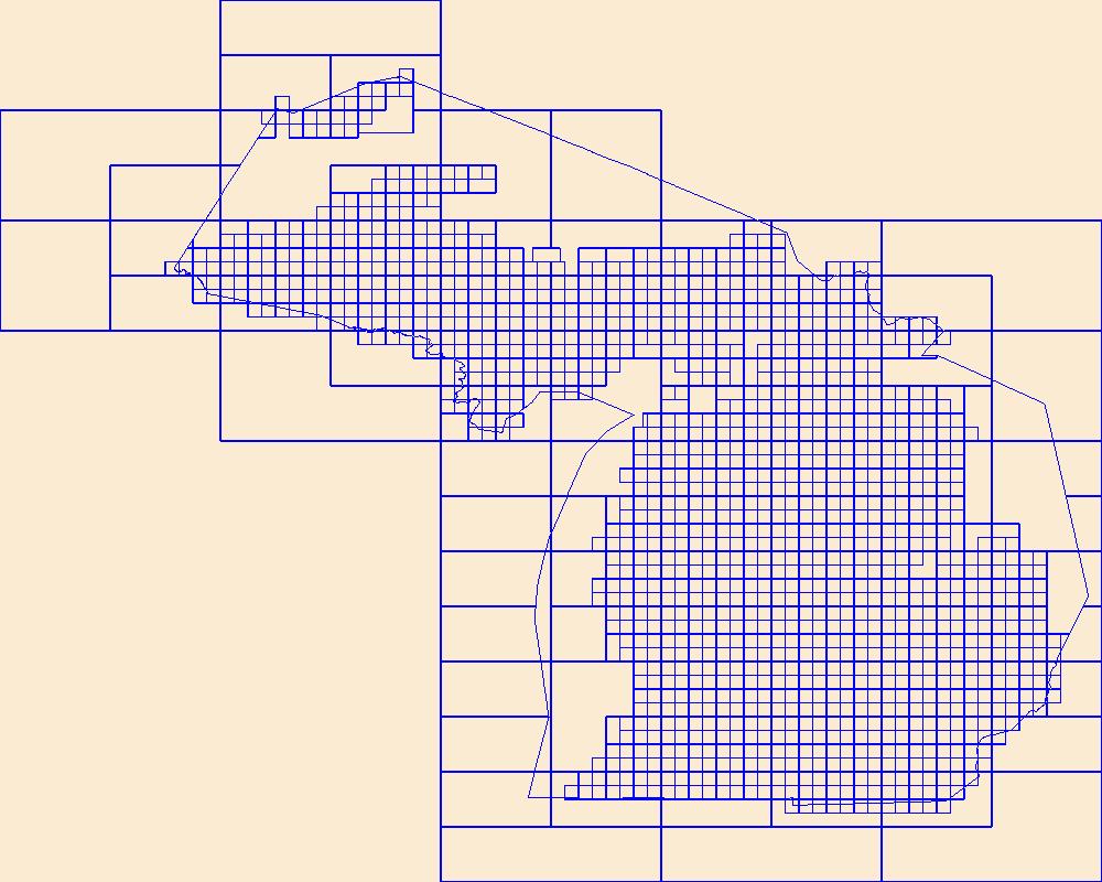
This data represents the map extent for current and historical USGS topographic maps for the United States and Territories, including 1 X 2 Degree, 1 X 1 Degree, 30 X 60 Minute, 15 X 15 Minute, 7.5 X 7.5 Minute, and 3.75 X 3.75 Minute. The grid was generated using ESRI ArcInfo GIS software.
Tags: Alcona,
Alger,
Allegan,
Alpena,
Antrim, All tags...
Arenac,
Baraga,
Barry,
Bay,
Benzie,
Berrien,
Boundaries,
Branch,
Calhoun,
Cass,
Charlevoix,
Cheboygan,
Chippewa,
Clare,
Clinton,
Crawford,
Delta,
Dickinson,
Downloadable Data,
Eaton,
Emmet,
Esri File GeoDatabase 10,
FileGDB,
Genesee,
Gladwin,
Gogebic,
Grand Traverse,
Gratiot,
Hillsdale,
Houghton,
Huron,
Ingham,
Ionia,
Iosco,
Iron,
Isabella,
Jackson,
Kalamazoo,
Kalkaska,
Kent,
Keweenaw,
Lake,
Lapeer,
Leelanau,
Lenawee,
Livingston,
Luce,
MI,
Mackinac,
Macomb,
Manistee,
Map Indices,
Map Indices,
Map Indices,
Marquette,
Mason,
Mecosta,
Menominee,
Michigan,
Midland,
Missaukee,
Monroe,
Montcalm,
Montmorency,
Muskegon,
Newaygo,
Oakland,
Oceana,
Ogemaw,
Ontonagon,
Osceola,
Oscoda,
Otsego,
Ottawa,
Presque Isle,
Roscommon,
Saginaw,
Sanilac,
Schoolcraft,
Shiawassee,
St. Clair,
St. Joseph,
State,
State,
Tuscola,
US,
United States,
United States of America,
Van Buren,
Washtenaw,
Wayne,
Wexford,
cells,
map indices,
polygon grid, Fewer tags
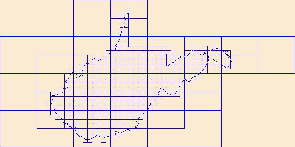
This data represents the map extent for current and historical USGS topographic maps for the United States and Territories, including 1 X 2 Degree, 1 X 1 Degree, 30 X 60 Minute, 15 X 15 Minute, 7.5 X 7.5 Minute, and 3.75 X 3.75 Minute. The grid was generated using ESRI ArcInfo GIS software.
Types: Citation;
Tags: Barbour,
Berkeley,
Boone,
Boundaries,
Braxton, All tags...
Brooke,
Cabell,
Calhoun,
Clay,
Doddridge,
Downloadable Data,
Esri Shapefile nan,
Fayette,
Gilmer,
Grant,
Greenbrier,
Hampshire,
Hancock,
Hardy,
Harrison,
Jackson,
Jefferson,
Kanawha,
Lewis,
Lincoln,
Logan,
Map Indices,
Map Indices,
Map Indices,
Marion,
Marshall,
Mason,
McDowell,
Mercer,
Mineral,
Mingo,
Monongalia,
Monroe,
Morgan,
Nicholas,
Ohio,
Pendleton,
Pleasants,
Pocahontas,
Preston,
Putnam,
Raleigh,
Randolph,
Ritchie,
Roane,
Shapefile,
State,
State,
Summers,
Taylor,
Tucker,
Tyler,
US,
United States,
United States of America,
Upshur,
WV,
Wayne,
Webster,
West Virginia,
Wetzel,
Wirt,
Wood,
Wyoming,
cells,
map indices,
polygon grid, Fewer tags
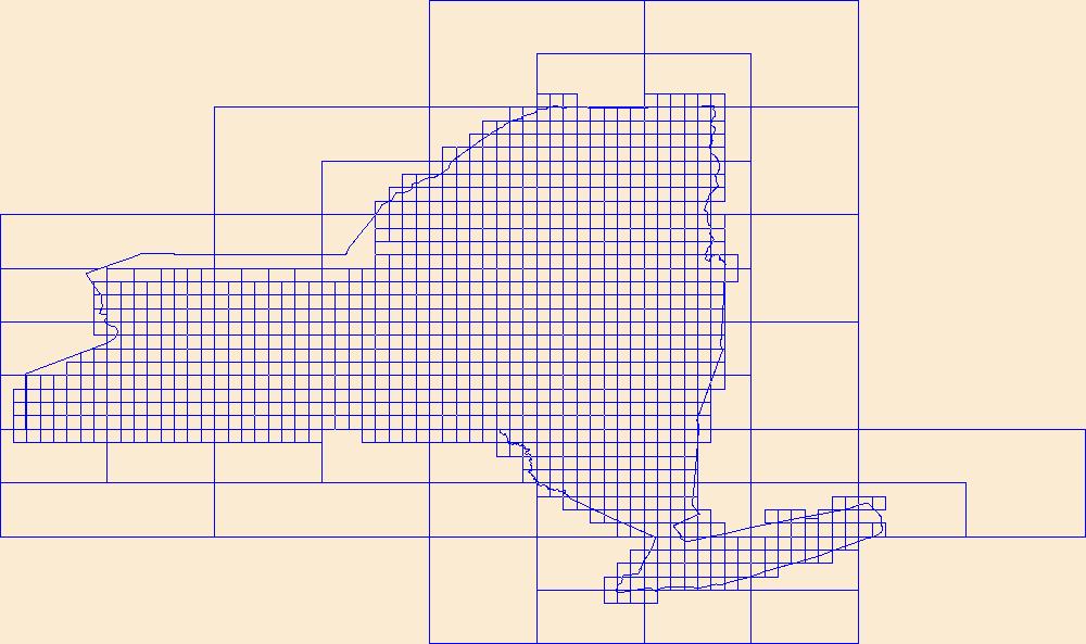
This data represents the map extent for current and historical USGS topographic maps for the United States and Territories, including 1 X 2 Degree, 1 X 1 Degree, 30 X 60 Minute, 15 X 15 Minute, 7.5 X 7.5 Minute, and 3.75 X 3.75 Minute. The grid was generated using ESRI ArcInfo GIS software.
Types: Citation;
Tags: Albany,
Allegany,
Boundaries,
Bronx,
Broome, All tags...
Cattaraugus,
Cayuga,
Chautauqua,
Chemung,
Chenango,
Clinton,
Columbia,
Cortland,
Delaware,
Downloadable Data,
Dutchess,
Erie,
Esri Shapefile nan,
Essex,
Franklin,
Fulton,
Genesee,
Greene,
Hamilton,
Herkimer,
Jefferson,
Kings,
Lewis,
Livingston,
Madison,
Map Indices,
Map Indices,
Map Indices,
Monroe,
Montgomery,
NY,
Nassau,
New York,
New York,
Niagara,
Oneida,
Onondaga,
Ontario,
Orange,
Orleans,
Oswego,
Otsego,
Putnam,
Queens,
Rensselaer,
Richmond,
Rockland,
Saratoga,
Schenectady,
Schoharie,
Schuyler,
Seneca,
Shapefile,
St. Lawrence,
State,
State,
Steuben,
Suffolk,
Sullivan,
Tioga,
Tompkins,
US,
Ulster,
United States,
United States of America,
Warren,
Washington,
Wayne,
Westchester,
Wyoming,
Yates,
cells,
map indices,
polygon grid, Fewer tags

This data represents the map extent for current and historical USGS topographic maps for the United States and Territories, including 1 X 2 Degree, 1 X 1 Degree, 30 X 60 Minute, 15 X 15 Minute, 7.5 X 7.5 Minute, and 3.75 X 3.75 Minute. The grid was generated using ESRI ArcInfo GIS software.
Tags: AS,
American Samoa,
Boundaries,
Downloadable Data,
Eastern, All tags...
Esri Shapefile nan,
Manu'a,
Map Indices,
Map Indices,
Map Indices,
Rose Island,
Shapefile,
State,
State,
Swains Island,
US,
United States,
United States of America,
Western,
cells,
map indices,
polygon grid, Fewer tags
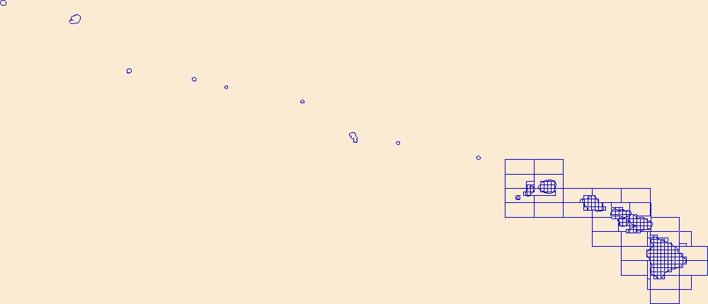
This data represents the map extent for current and historical USGS topographic maps for the United States and Territories, including 1 X 2 Degree, 1 X 1 Degree, 30 X 60 Minute, 15 X 15 Minute, 7.5 X 7.5 Minute, and 3.75 X 3.75 Minute. The grid was generated using ESRI ArcInfo GIS software.
Tags: Boundaries,
Downloadable Data,
Esri File GeoDatabase 10,
FileGDB,
HI, All tags...
Hawaii,
Hawaii,
Honolulu,
Kalawao,
Kauai,
Map Indices,
Map Indices,
Map Indices,
Maui,
State,
State,
US,
United States,
United States of America,
cells,
map indices,
polygon grid, Fewer tags

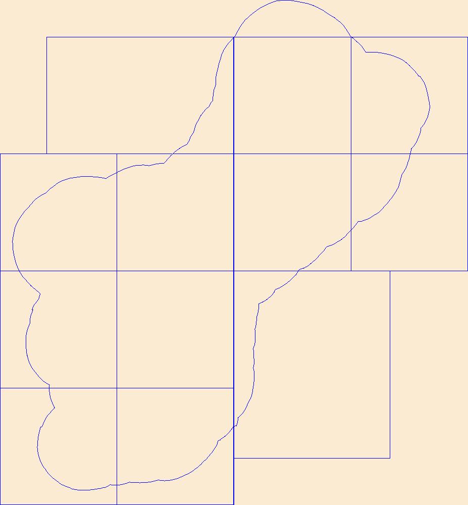
The Assessment Unit is the fundamental unit used in the National Assessment Project for the assessment of undiscovered oil and gas resources. The Assessment Unit is defined within the context of the higher-level Total Petroleum System. The Assessment Unit is shown here as a geographic boundary interpreted, defined, and mapped by the geologists responsible for the province and incorporates a set of known or postulated oil and (or) gas accumulations sharing similar geologic, geographic, and temporal properties within the Total Petroleum System, such as source rock, timing, migration pathways, trapping mechanism, and hydrocarbon type. The Assessment Unit boundary is defined geologically as the limits of the geologic...
Categories: Data,
pre-SM502.8;
Types: Downloadable,
Map Service,
OGC WFS Layer,
OGC WMS Layer,
Shapefile;
Tags: 47 = Western Gulf,
48 = East Texas Basin,
49 = Louisiana-Mississippi Salt Basins,
504701 = Upper Jurassic-Cretaceous-Tertiary Composite,
50470140 = Lower Miocene Shelf Oil And Gas, All tags...
50470141 = Lower Miocene Slope And Basin Gas,
50470142 = Middle Miocene Shelf Oil And Gas,
50470143 = Middle Miocene Slope And Basin Gas,
50470144 = Upper Miocene Shelf Oil And Gas,
50470145 = Upper Miocene Slope And Basin Gas,
50470146 = Plio-Pleistocene Shelf Oil And Gas,
AL,
Assessment Unit,
Cells,
Condon, S.M.,
Dubiel, R.F.,
Earth Science,
East Texas Basin,
Economic geology,
Energy Resources,
Geology,
Gulf Coast,
LA,
Louisiana-Mississippi Salt Basins,
MS,
Miocene Series,
National Assessment of Oil and Gas,
Natural Gas,
Natural Resources,
Natural gas resources,
Neogene System,
Oil,
Oil sand resources,
Oil shale resources,
Pearson, O.,
Pitman, J.K.,
Plio-Pleistocene Series,
Resource Assessment,
TX,
U.S. Geological Survey,
US01 = Alabama,
US22 = Louisiana,
US28 = Mississippi,
US48 = Texas,
USGS,
USGS Science Data Catalog (SDC),
USGS World Energy Region 5,
USGS World Energy Region 5,
United States,
Western Gulf,
geoscientificInformation,
gulfroom,
noga2000,
nogaflorida,
nogagulf,
nogatertiary,
oilgas, Fewer tags

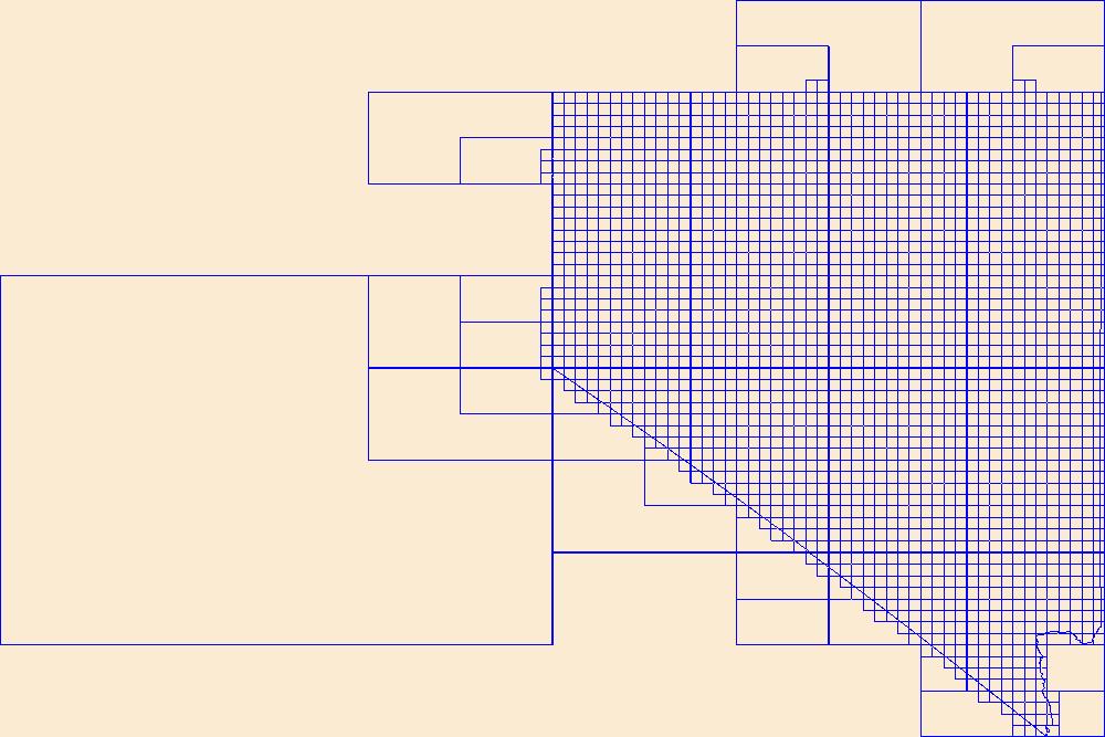
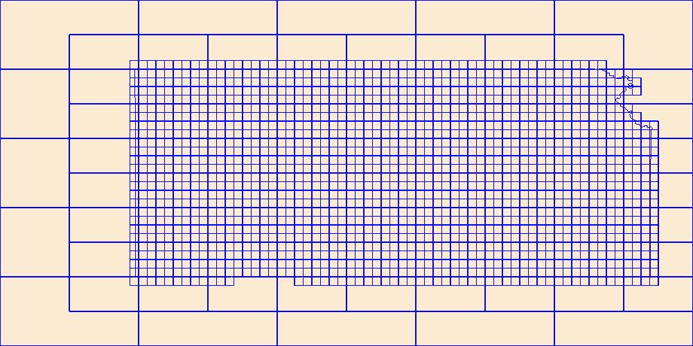
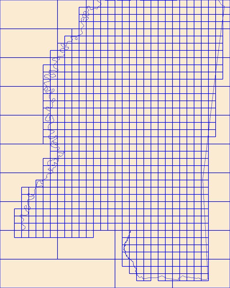
Cell maps for each oil and gas assessment unit were created by the USGS to illustrate the degree of exploration, type of production, and distribution of production in an assessment unit or province. Each cell represents a quarter-mile square of the land surface, and the cells are coded to represent whether the wells included within the cell are predominantly oil-producing, gas-producing, both oil and gas-producing, dry, or the type of production of the wells located within the cell is unknown. The well information was initially retrieved from the IHS Energy Group, PI/Dwights PLUS Well Data on CD-ROM, which is a proprietary, commercial database containing information for most oil and gas wells in the U.S. Cells were...
Categories: Data,
pre-SM502.8;
Types: Downloadable,
Map Service,
OGC WFS Layer,
OGC WMS Layer,
Shapefile;
Tags: 500401 = Cretaceous-Tertiary Composite,
50040101 = Western Oregon and Washington Conventional Gas,
500402 = Tertiary Marine,
50040201 = Tertiary Marine Gas,
500403 = Tertiary Coalbed Gas, All tags...
50040381 = Eocene Coalbed Gas,
Assessment Unit,
Brownfield, M.,
Cells,
Coalbed methane resources,
Earth Science,
Economic geology,
Energy Resources,
Gas hydrate resources,
Geology,
National Assessment of Oil and Gas,
Natural Gas,
Natural Resources,
OR,
Oil,
Oil sand resources,
Oil shale resources,
Resource Assessment,
U.S. Geological Survey,
US41 = Oregon,
US53 = Washington,
USGS,
USGS Science Data Catalog (SDC),
USGS World Energy Region 5,
USGS World Energy Region 5,
United States,
WA,
Western Oregon-Washington,
Western Oregon-Washington,
geoscientificInformation,
noga2000,
nogaworegon,
oilgas, Fewer tags

Cell maps for each oil and gas assessment unit were created by the USGS as a method for illustrating the degree of exploration, type of production, and distribution of production in an assessment unit or province. Each cell represents a quarter-mile square of the land surface, and the cells are coded to represent whether the wells included within the cell are predominantly oil-producing, gas-producing, both oil and gas-producing, dry, or the type of production of the wells located within the cell is unknown. The well information was initially retrieved from the IHS Energy Group, PI/Dwights PLUS Well Data on CD-ROM, which is a proprietary, commercial database containing information for most oil and gas wells in the...
Categories: Data,
pre-SM502.8;
Types: Downloadable,
Map Service,
OGC WFS Layer,
OGC WMS Layer,
Shapefile;
Tags: 504501 = Barnett Paleozoic,
50450101 = Paleozoic Shelf and Bank Carbonate Oil and Gas,
50450102 = Mississippian Chappel Pinnacle Reef Oil and Gas,
50450161 = Greater Newark East Frac-Barrier Continuous Barnett Shale Gas,
50450162 = Extended Continuous Barnett Shale Gas, All tags...
50450163 = Hypothetical Basin-Arch Continuous Barnett Shale Oil,
504502 = Barnett-Hardeman Basin,
50450201 = Mississippian Dolomitized Chappel Waulsortian Mound Oil,
50450202 = Paleozoic Clastic-Carbonate Oil,
50450261 = Hypothetical Continuous Fractured Barnett Shale Oil,
504503 = Pennsylvanian Bend-Broken Bone Graben,
50450301 = Fluvial Sandstone-Carbonate Bank Gas and Oil,
504504 = Pennsylvanian-Lower Permian Coal Bed Gas,
50450481 = Hypothetical Pennsylvanian Bituminous Coal Bed Gas,
Assessment Unit,
Bend Arch,
Bend Arch-Fort Worth Basin,
Cells,
Coalbed methane resources,
Earth Science,
Economic geology,
Energy Resources,
Fort Worth,
Fort Worth-Bend Arch Basin,
Gas hydrate resources,
Geology,
National Assessment of Oil and Gas,
Natural Gas,
Natural Resources,
Natural gas resources,
OK,
Oil,
Oil sand resources,
Oil shale resources,
Pollastro, R.M.,
Resource Assessment,
TX,
U.S. Geological Survey,
US40 = Oklahoma,
US48 = Texas,
USGS,
USGS Science Data Catalog (SDC),
USGS World Energy Region 5,
USGS World Energy Region 5,
United States,
geoscientificInformation,
noga2000,
nogafort,
oilgas, Fewer tags

Cell maps for each oil and gas assessment unit were created by the USGS to illustrate the degree of exploration, type of production, and distribution of production in an assessment unit or province. Each cell represents a quarter-mile square of the land surface, and the cells are coded to represent whether the wells included within the cell are predominantly oil-producing, gas-producing, both oil and gas-producing, dry, or the type of production of the wells located within the cell is unknown. The well information was initially retrieved from the IHS Energy Group, PI/Dwights PLUS Well Data on CD-ROM, which is a proprietary, commercial database containing information for most oil and gas wells in the U.S. Cells were...
Categories: Data,
pre-SM502.8;
Types: Downloadable,
Map Service,
OGC WFS Layer,
OGC WMS Layer,
Shapefile;
Tags: 506301 = Precambrian Nonesuch,
50630101 = Precambrian Nonesuch,
506302 = Ordovician Foster,
50630201 = Ordovician Sandstones and Carbonates,
506303 = Ordovician to Devonian Composite, All tags...
50630301 = Ordovician Trenton/Black River,
50630302 = Silurian Burnt Bluff,
50630303 = Silurian A-1 Carbonate Structural,
50630304 = Middle Devonian Carbonates,
50630305 = Devonian to Mississippian Berea/Michigan Sandstone,
50630361 = Devonian Antrim Continuous Oil,
50630362 = Ordovician Collingwood Shale Gas,
506304 = Silurian Niagara/Salina,
50630401 = Silurian Niagara,
50630402 = Devonian Sylvania Sandstone,
506305 = Devonian Antrim,
50630561 = Devonian Antrim Continuous Gas,
506306 = Pennsylvanian Saginaw,
50630681 = Pennsylvanian Saginaw Coalbed Gas,
Assessment Unit,
Cells,
Coalbed methane resources,
Earth Science,
Economic geology,
Energy Resources,
Geology,
IL,
IN,
MI,
Michigan Basin,
Michigan Basin,
National Assessment of Oil and Gas,
Natural Gas,
Natural Resources,
Natural gas resources,
OH,
Oil,
Oil sand resources,
Oil shale resources,
Resource Assessment,
Swezey, C.S.,
U.S. Geological Survey,
US17 = Illinois,
US18 = Indiana,
US26 = Michigan,
US39 = Ohio,
US55 = Wisconsin,
USGS,
USGS Science Data Catalog (SDC),
USGS World Energy Region 5,
USGS World Energy Region 5,
United States,
WI,
geoscientificInformation,
noga2000,
nogamichigan,
oilgas, Fewer tags

Cell maps for each oil and gas assessment unit were created by the USGS as a method for illustrating the degree of exploration, type of production, and distribution of production in an assessment unit or province. Each cell represents a quarter-mile square of the land surface, and the cells are coded to represent whether the wells included within the cell are predominantly oil-producing, gas-producing, both oil and gas-producing, dry, or the type of production of the wells located within the cell is unknown. The well information was initially retrieved from the IHS Energy Group, PI/Dwights PLUS Well Data on CD-ROM, which is a proprietary, commercial database containing information for most oil and gas wells in the...
Categories: Data,
pre-SM502.8;
Types: Downloadable,
Map Service,
OGC WFS Layer,
OGC WMS Layer,
Shapefile;
Tags: 506501 = Chattanooga Shale/Floyd Shale-Paleozoic,
50650101 = Pre-Mississippian Carbonates Gas,
50650102 = Carboniferous Sandstones Oil and Gas,
506502 = Pottsville Coal,
50650281 = Black Warrior Basin Coalbed Gas, All tags...
65 = Black Warrior,
AL,
Assessment Unit,
Black Warrior,
Cells,
Coalbed methane resources,
Earth Science,
Economic geology,
Energy Resources,
Gas hydrate resources,
Geology,
MS,
National Assessment of Oil and Gas,
Natural Gas,
Natural Resources,
Natural gas resources,
Oil,
Oil sand resources,
Oil shale resources,
Resource Assessment,
Schenk, C.J.,
U.S. Geological Survey,
US01 = Alabama,
US28 = Mississippi,
USGS,
USGS Science Data Catalog (SDC),
USGS World Energy Region 5,
USGS World Energy Region 5,
United States,
geoscientificInformation,
noga2000,
nogabwarrior,
oilgas, Fewer tags
Cell maps for each oil and gas assessment unit were created by the USGS as a method for illustrating the degree of exploration, type of production, and distribution of production in an assessment unit or province. Each cell represents a quarter-mile square of the land surface, and the cells are coded to represent whether the wells included within the cell are predominantly oil-producing, gas-producing, both oil and gas-producing, dry, or the type of production of the wells located within the cell is unknown. The well information was initially retrieved from the IHS Energy Group, PI/Dwights PLUS Well Data on CD-ROM, which is a proprietary, commercial database containing information for most oil and gas wells in the...
Categories: pre-SM502.8;
Tags: 506701 = Conasauga-Rome/Conasauga,
50670101 = Rome Trough,
506702 = Sevier-Knox Trenton,
50670201 = Lower Paleozoic Carbonates,
506703 = Utica-Lower Paleozoic, All tags...
50670301 = Lower Paleozoic Carbonates in Thrust Belt,
50670302 = Knox Unconformity,
50670303 = Black River-Trenton Hydrothermal Dolomite,
50670304 = Lockport Dolomite,
50670361 = Clinton-Medina Basin Center,
50670362 = Clinton-Medina Transitional Northeast,
50670363 = Clinton-Medina Transitional,
50670364 = Tuscarora Basin Center,
506704 = Devonian Shale-Middle and Upper Paleozoic,
50670401 = Oriskany Sandstone-Structural,
50670402 = Oriskany Sandstone-Stratigraphic,
50670403 = Greenbrier Limestone,
50670404 = Mississippian Sandstones,
50670461 = Greater Big Sandy,
50670462 = Northwestern Ohio Shale,
50670463 = Devonian Siltstone and Shale,
50670464 = Marcellus Shale,
50670465 = Catskill Sandstones and Siltstone,
50670466 = Berea Sandstone,
506705 = Carboniferous Coal-Bed Gas,
50670581 = Pocahontas Basin,
50670582 = East Dunkard (Folded),
50670583 = West Dunkard (Unfolded),
50670584 = Central Appalachian Shelf,
50670585 = Appalachain Anthracite and Semi-Anthracite,
506706 = Pottsville Coal-Bed Gas,
50670681 = Cahaba Basin,
67 = Appalachian Basin,
AL,
Appalachian Basin,
Assessment Unit,
Cells,
Coalbed methane resources,
Earth Science,
Economic geology,
Energy Resources,
GA,
Gas hydrate resources,
Geology,
KY,
MD,
Milici, Robert C.,
NC,
NJ,
NY,
National Assessment of Oil and Gas,
Natural Gas,
Natural Resources,
Natural gas resources,
OH,
Oil,
Oil sand resources,
Oil shale resources,
PA,
Resource Assessment,
TN,
U.S. Geological Survey,
US01 = Alabama,
US13 = Georgia,
US21 = Kentucky,
US24 = Maryland,
US34 = New Jersey,
US36 = New York,
US37 = North Carolina,
US39 = Ohio,
US42 = Pennsylvania,
US47 = Tennessee,
US51 = Virginia,
US54 = West Virginia,
USGS,
USGS Science Data Catalog (SDC),
USGS World Energy Region 5,
USGS World Energy Region 5,
United States,
VA,
WV,
geoscientificInformation,
noga2000,
nogaappalachian,
oilgas, Fewer tags

Cell maps for each oil and gas assessment unit were created by the USGS as a method for illustrating the degree of exploration, type of production, and distribution of production in an assessment unit or province. Each cell represents a quarter-mile square of the land surface, and the cells are coded to represent whether the wells included within the cell are predominantly oil-producing, gas-producing, both oil and gas-producing, dry, or the type of production of the wells located within the cell is unknown. The well information was initially retrieved from the IHS Energy Group, PI/Dwights PLUS Well Data on CD-ROM, which is a proprietary, commercial database containing information for most oil and gas wells in the...
Categories: Data,
pre-SM502.8;
Tags: 506701 = Conasauga-Rome/Conasauga,
50670101 = Rome Trough,
506702 = Sevier-Knox Trenton,
50670201 = Lower Paleozoic Carbonates,
506703 = Utica-Lower Paleozoic, All tags...
50670301 = Lower Paleozoic Carbonates in Thrust Belt,
50670302 = Knox Unconformity,
50670303 = Black River-Trenton Hydrothermal Dolomite,
50670304 = Lockport Dolomite,
50670361 = Clinton-Medina Basin Center,
50670362 = Clinton-Medina Transitional Northeast,
50670363 = Clinton-Medina Transitional,
50670364 = Tuscarora Basin Center,
506704 = Devonian Shale-Middle and Upper Paleozoic,
50670401 = Oriskany Sandstone-Structural,
50670402 = Oriskany Sandstone-Stratigraphic,
50670403 = Greenbrier Limestone,
50670404 = Mississippian Sandstones,
50670461 = Greater Big Sandy,
50670462 = Northwestern Ohio Shale,
50670463 = Devonian Siltstone and Shale,
50670464 = Marcellus Shale,
50670465 = Catskill Sandstones and Siltstone,
50670466 = Berea Sandstone,
506705 = Carboniferous Coal-Bed Gas,
50670581 = Pocahontas Basin,
50670582 = East Dunkard (Folded),
50670583 = West Dunkard (Unfolded),
50670584 = Central Appalachian Shelf,
50670585 = Appalachain Anthracite and Semi-Anthracite,
506706 = Pottsville Coal-Bed Gas,
50670681 = Cahaba Basin,
67 = Appalachian Basin,
AL,
Appalachian Basin,
Assessment Unit,
Cells,
Coalbed methane resources,
Earth Science,
Economic geology,
Energy Resources,
GA,
Gas hydrate resources,
Geology,
KY,
MD,
Milici, Robert C.,
NC,
NJ,
NY,
National Assessment of Oil and Gas,
Natural Gas,
Natural Resources,
Natural gas resources,
OH,
Oil,
Oil sand resources,
Oil shale resources,
PA,
Resource Assessment,
TN,
U.S. Geological Survey,
US01 = Alabama,
US13 = Georgia,
US21 = Kentucky,
US24 = Maryland,
US34 = New Jersey,
US36 = New York,
US37 = North Carolina,
US39 = Ohio,
US42 = Pennsylvania,
US47 = Tennessee,
US51 = Virginia,
US54 = West Virginia,
USGS,
USGS Science Data Catalog (SDC),
USGS World Energy Region 5,
USGS World Energy Region 5,
United States,
VA,
WV,
geoscientificInformation, Fewer tags

This data represents the map extent for current and historical USGS topographic maps for the United States and Territories, including 1 X 2 Degree, 1 X 1 Degree, 30 X 60 Minute, 15 X 15 Minute, 7.5 X 7.5 Minute, and 3.75 X 3.75 Minute. The grid was generated using ESRI ArcInfo GIS software.
Types: Citation;
Tags: Boundaries,
DE,
Delaware,
Downloadable Data,
Esri Shapefile nan, All tags...
Kent,
Map Indices,
Map Indices,
Map Indices,
New Castle,
Shapefile,
State,
State,
Sussex,
US,
United States,
United States of America,
cells,
map indices,
polygon grid, Fewer tags

This data represents the map extent for current and historical USGS topographic maps for the United States and Territories, including 1 X 2 Degree, 1 X 1 Degree, 30 X 60 Minute, 15 X 15 Minute, 7.5 X 7.5 Minute, and 3.75 X 3.75 Minute. The grid was generated using ESRI ArcInfo GIS software.
Tags: Barbour,
Berkeley,
Boone,
Boundaries,
Braxton, All tags...
Brooke,
Cabell,
Calhoun,
Clay,
Doddridge,
Downloadable Data,
Esri File GeoDatabase 10,
Fayette,
FileGDB,
Gilmer,
Grant,
Greenbrier,
Hampshire,
Hancock,
Hardy,
Harrison,
Jackson,
Jefferson,
Kanawha,
Lewis,
Lincoln,
Logan,
Map Indices,
Map Indices,
Map Indices,
Marion,
Marshall,
Mason,
McDowell,
Mercer,
Mineral,
Mingo,
Monongalia,
Monroe,
Morgan,
Nicholas,
Ohio,
Pendleton,
Pleasants,
Pocahontas,
Preston,
Putnam,
Raleigh,
Randolph,
Ritchie,
Roane,
State,
State,
Summers,
Taylor,
Tucker,
Tyler,
US,
United States,
United States of America,
Upshur,
WV,
Wayne,
Webster,
West Virginia,
Wetzel,
Wirt,
Wood,
Wyoming,
cells,
map indices,
polygon grid, Fewer tags
|
|

