Filters: Tags: Census (X)
41 results (90ms)|
Filters
Date Range
Extensions (Less)
Types (Less)
Contacts (Less)
Categories (Less) Tag Types
|
Map containing historical census data from 1900 - 2000 throughout the western United States at the county level. Data includes total population, population density, and percent population change by decade for each county. Population data was obtained from the US Census Bureau and joined to 1:2,000,000 scale National Atlas counties shapefile.
Categories: Data;
Types: Downloadable,
Map Service,
OGC WFS Layer,
OGC WMS Layer,
Shapefile;
Tags: Arizona,
California,
Colorado,
Idaho,
Montana,

These data were released prior to the October 1, 2016 effective date for the USGS’s policy dictating the review, approval, and release of scientific data as referenced in USGS Survey Manual Chapter 502.8 Fundamental Science Practices: Review and Approval of Scientific Data for Release. Septic systems are useful for removing and processing human waste. However, they have the potential of leaking or discharging waste into the nearby system and increasing potential contamination of nearby streams. Data represent potential locations of septic sewers in the Pacific Northwest based on extrapolation of 1990 Census tract block group level information.
This thematic map illustrates the median value of houses in the United States in 2010. The 2010 median home value is an estimate of home value based on total owner occupied units. This data variable is included in Esri's Updated Demographics (2010/2015). This map shows Esri's 2010 estimates using Census 2000 geographies. The map is designed to be displayed with a 30–50 percent semi-transparency for overlay on other basemaps as noted in the map legend. A basemap with relatively few colors, such as Terrain, This thematic map illustrates the median value of houses in the United States in 2010. The 2010 median home value is an estimate of home value based on total owner occupied units. This data variable is included...
Categories: Data;
Types: ArcGIS REST Map Service,
Map Service;
Tags: Census,
Demographis,
Tracts,
US Department of Commerce,
Us Census Bureau,
This map shows Census boundaries and other features on a simple, mostly white basemap. The map displays the 2009 TIGER data. This map is designed to complement colorful basemaps and thematic layers, such as Census demographics. It is intended for census experts and the general public alike. This map shows Census boundaries and other features on a simple, mostly white basemap. The map displays the 2009 TIGER data. This map is designed to complement colorful basemaps and thematic layers, such as Census demographics. It is intended for census experts and the general public alike. The map includes water features, railway, roads, and administrative boundaries (city and town limits, metropolitan statistical...
Categories: Data;
Types: ArcGIS REST Map Service,
Map Service;
Tags: Census,
Counties,
Population Density,
States
Montana Population in persons per square mile from the 2000 Census. This data is a smoothed-over representation of Montana's population density surface, designed to emphasize small areas with high population density. It was derived from U.S. Census Bureau 2000 TIGER files and population counts. The original data was resampled to a 100-meter grid, smoothed, and the highest resulting density of the 100-meter cells in each 1-kilometer grid cell was assigned to the cell. When comparing this data set to the similar data set available from NRIS for the 1990 Census, it is important to realize that the change of population density at a location is likely to be the result of a change in the configuration of the Census...
Categories: Data;
Types: Downloadable,
Map Service,
OGC WFS Layer,
OGC WMS Layer,
Shapefile;
Tags: Census,
Montana,
Mt,
population density
US Census 2000 State of Wyoming Boundary
Federal American Indian reservations are areas that have been set aside by the United States for the use of tribes. The U.S. Census Bureau recognizes federal reservations as territory over which American Indian tribes have primary governmental authority. This shapefile is for Wyoming reservation boundaries only.
Categories: Data;
Types: Downloadable;
Tags: Demographic,
Indian,
Native American,
Reservation,
WRIR,
Tribal census tracts are small, relatively permanent statistical subdivisions of a federally recognized American Indian reservation and/or off-reservation trust land. The optimum size for a tribal census tract is 2,500 people; it must contain a minimum of 1,000 people. The difference between a tribal census tract and a nontribal census tract is in the hierarchical presentation of the data. A tribal census tract is part of the American Indian hierarchy; that is, the tribal census tract is within a federally recognized American Indian reservation and/or off-reservation trust land.
Categories: Data;
Types: Downloadable;
Tags: Census,
Federal Government,
US Census,
demographics,
society
Wyoming state senate districts with demographic data.
Categories: Data;
Types: Downloadable;
Tags: Census,
Federal Government,
US Census,
boundaries,
demographics,
NSDI ADMINISTRATIVE BOUNDARIES DATA IS PRODUCED BY THE US CENSUS BUREAU. This web service contains the following Census 2010 TIGER boundary datasets for the entire state of Montana: NSDI ADMINISTRATIVE BOUNDARIES DATA IS PRODUCED BY THE US CENSUS BUREAU. This web service contains the following Census 2010 TIGER boundary datasets for the entire state of Montana: State Block Group Tract Places: City, Town, Census Designated Place (CDP) Reservation Boundaries & Trust Lands County Access and Use Constraints These datasets were downloaded from the US Census Bureau. Data calculations were made by CEIC and the data is hosted by the Base Map Service Center.
Categories: Data;
Types: ArcGIS REST Map Service,
Map Service;
Tags: CEIC,
Census,
MSDI,
Montana,
Montana Base Map Service Center,
The National Coral Reef Monitoring Program (NCRMP)’s biological sampling provides a biennial ecological characterization of general reef condition for reef fishes, corals, and benthic habitat (i.e., fish species composition, density, and size; coral species composition, density, size, condition; and benthic community cover) at a broad spatial scale. In the U.S. Atlantic, NCRMP biological sampling includes coral reef and hardbottom habitats in Florida, Flower Garden Banks, Puerto Rico, and the U.S. Virgin Islands (USVI). NCRMP Fish surveys are conducted using the Reef Visual Census (RVC) stationary point count method (Brandt et al. 2009). Fish surveys are conducted at all NCRMP biological survey sites and may occur...
Our primary goal for this dataset was to obtain the population and number of dwellings at the finest common scale possible. Because the Canadian government first began to collect the pertinent census information at our desired scale in 2006, we used 2006 as the baseline for this product on the Canadian CCE. However, because (1) U.S. Census takes place every 10 years, and (2) our desired baseline date for the protocol was 2000, the census 2000 blocks were used on the U.S. CCE. This dataset was developed by the Crown Managers Partnership, as part of a transboundary collaborative management initiative for the Crown of the Continent Ecosystem, based on commonly identified management priorities that are relevant at the...
Categories: Data;
Types: Citation,
Downloadable,
Map Service,
OGC WFS Layer,
OGC WMS Layer,
Shapefile;
Tags: Alberta,
Alberta,
British Columbia,
British Columbia,
CCE,
This thematic map illustrates the median age of people in the United States in 2010; the Median Age for the U.S. is 37 years. Median Age is calculated from the distribution of age by five-year ranges. This data is from Esri's Updated Demographics (2010/2015) database. This thematic map illustrates the median age of people in the United States in 2010; the Median Age for the U.S. is 37 years. Median Age is calculated from the distribution of age by five-year ranges. This data is from Esri's Updated Demographics (2010/2015) database. This map shows Esri's 2010 estimates using Census 2000 geographies. The geography depicts States at greater than 25m scale, Counties at 750k to 25m scale, Census Tracts at 150k...
In 1998, the Florida Fish and Wildlife Conservation Commission's (FWC) Fisheries Independent Monitoring (FIM) program began a long-term monitoring effort of key reef fish populations in the Florida Keys National Marine Sanctuary. This effort was aimed at evaluating the relative abundance, size structure, and habitat utilization of specific reef fish species that are targeted by commercial and recreational fisheries.
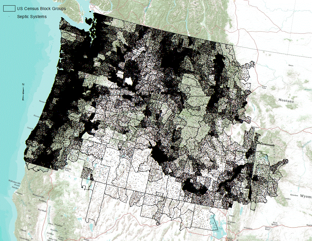
Septic systems are useful for removing and processing human waste. However, they have the potential of leaking or discharging waste into the nearby system and increasing potential contamination of nearby streams. Data represent potential locations of septic sewers in the Pacific Northwest based on extrapolation of 1990 Census tract block group level information.
Montana Population in persons per square mile. Derived from 1990 U.S. Census Bureau TIGER files and population counts. The original data was smoothed, and the highest resulting density in each 1-kilometer grid cell was assigned to the cell. See /gis2/montwork/cmp/94/94nris98e.aml for exact method used to create this grid.
Categories: Data;
Types: Downloadable,
Map Service,
OGC WFS Layer,
OGC WMS Layer,
Shapefile;
Tags: Census,
MT,
population density
A map service on the www depicting the location and boundaries of the United States, the District of Columbia and the US territories. It includes common identifiers for these entities so this data set can be used in conjunction with other data sets describing states. This map service uses a generalized states layer for display at small scales. The data are an extract of the Census codes and boundaries from the following Census FTP site: ftp://ftp2.census.gov/geo/tiger. Since the Census data do not include the coastline detail, the coastal boundaries have been spatially clipped to the Health Resources and Services Administration (HRSA) coastline detail. This coastline detail was derived from the Census water blocks...
In 1998, the Florida Fish and Wildlife Conservation Commission's (FWC) Fisheries Independent Monitoring (FIM) program began a long-term monitoring effort of key reef fish populations in the Florida Keys National Marine Sanctuary. This effort was aimed at evaluating the relative abundance, size structure, and habitat utilization of specific reef fish species that are targeted by commercial and recreational fisheries.; Smith,S.G., et al. 2011,Multispecies survey design for assessing reef-fish stocks, spatially explicit management performance, and ecosystem condition. Fisheries Research 109(2011)25-41; Brandt,M.E., et. al. 2009,A Cooperative Multi-agency Reef Fish Monitoring Protocol for the Florida Keys Coral Reef...
Categories: Data;
Types: NetCDF OPeNDAP Service;
Tags: Atmosphere > Air Quality > Visibility,
Dry Tortugas Reef Visual Census 2016,
absence,
air,
aphia,
The US Department of Agriculture (USDA) National Agricultural Statistics Service (NASS) and the USDA Census of Agriculture (completed every five years, most recently in 2012) are primary sources of regionally detailed data concerning the productivity, economics, land use, and multiple other characteristics of agriculture and ranching in the United States. The county-level data on farmland irrigation provides one example of the many ways in which agriculture impacts, and is impacted by, natural resource availability and sustainability. This featured dataset is acres irrigated in farmlands, 2012. Available at: www.agcensus.usda.gov/Publications/2012/</pre>
Categories: Data;
Types: ArcGIS REST Map Service,
ArcGIS Service Definition,
Citation,
Downloadable,
Map Service;
Tags: Academics & scientific researchers,
AppLCC,
AppLCC,
Appalachian,
Conservation NGOs,
This thematic map presents the average household size in the United States in 2010; the average household size for the U.S. in 2010 is 2.59. The 2010 Average Household Size is the household population divided by total households. This map shows Esri's 2010 estimates using Census 2000 geographies. The geography depicts States at greater than 25m scale, Counties at 750k to 25m scale, Census Tracts at 150k to 750km scale, and Census Block Groups at less than 150k scale. This thematic map presents the average household size in the United States in 2010; the average household size for the U.S. in 2010 is 2.59. The 2010 Average Household Size is the household population divided by total households. This map shows...
Categories: Data;
Types: ArcGIS REST Map Service,
Map Service;
Tags: Census,
Children,
DOC,
Demographics,
US Census Bureau,
|

|
