Filters: Tags: Classification (X)
40 results (69ms)|
Filters
Contacts
(Less)
|

These data were released prior to the October 1, 2016 effective date for the USGS’s policy dictating the review, approval, and release of scientific data as referenced in USGS Survey Manual Chapter 502.8 Fundamental Science Practices: Review and Approval of Scientific Data for Release. Estuarine ecosystems are controlled by a variety of processes that operate at multiple spatial and temporal scales. Understanding the hierarchical nature of these processes will aid in prioritization of restoration efforts. This hierarchical Columbia River Estuary Ecosystem Classification (henceforth "Classification") of the Columbia River estuary is a spatial database of the tidally-influenced reaches of the lower Columbia River,...

These data were released prior to the October 1, 2016 effective date for the USGS’s policy dictating the review, approval, and release of scientific data as referenced in USGS Survey Manual Chapter 502.8 Fundamental Science Practices: Review and Approval of Scientific Data for Release. Estuarine ecosystems are controlled by a variety of processes that operate at multiple spatial and temporal scales. Understanding the hierarchical nature of these processes will aid in prioritization of restoration efforts. This hierarchical Columbia River Estuary Ecosystem Classification (henceforth "Classification") of the Columbia River estuary is a spatial database of the tidally-influenced reaches of the lower Columbia River,...
This dataset represents the soil order from SSURGO and STATSGO soil descriptions for soil map units in the state of southern Alaska (b) that lie within the North Pacific Landscape Conservation Cooperative.
River valley boundary extents were generated for select large river floodplains of the Upper Midwest, United States. These polygons were delineated using a method that incorporated interpolating a water surface elevation that completely over-topped water-control structures within the valley such as levees, flood walls, and roadways. The intersection of this derived water surface and land elevation at the outermost edge of the floodplain was used to delineate the approximate extent of the river valley boundary. We used best professional judgment to approximate this water surface elevation.
Categories: Data;
Types: Downloadable,
Map Service,
OGC WFS Layer,
OGC WMS Layer,
Shapefile;
Tags: Illinois,
Indiana,
Iowa,
Kansas,
Kentucky,
This dataset is a component of a complete package of products from the Connect the Connecticut project. Connect the Connecticut is a collaborative effort to identify shared priorities for conserving the Connecticut River Watershed for future generations, considering the value of fish and wildlife species and the natural ecosystems they inhabit. Click here to download the full data package, including all documentation.This dataset represents the climate response index for Eastern Meadowlark. Climate response is one of several different measures of landscape capability that reflect different decisions (or assumptions) regarding how to incorporate current versus future land use and climate changes. The climate response...
Categories: Data;
Types: ArcGIS REST Map Service,
ArcGIS Service Definition,
Citation,
Downloadable,
Map Service;
Tags: Data,
LCC Network Science Catalog,
North Atlantic Landscape Conservation Cooperative Data.gov,
change,
change,
This dataset is a component of a complete package of products from the Connect the Connecticut project. Connect the Connecticut is a collaborative effort to identify shared priorities for conserving the Connecticut River Watershed for future generations, considering the value of fish and wildlife species and the natural ecosystems they inhabit. Click here to download the full data package, including all documentation.This dataset represents the climate response index for Moose. Climate response is one of several different measures of landscape capability that reflect different decisions (or assumptions) regarding how to incorporate current versus future land use and climate changes. The climate response index is...
Categories: Data;
Types: ArcGIS REST Map Service,
ArcGIS Service Definition,
Citation,
Downloadable,
Map Service;
Tags: Data,
LCC Network Science Catalog,
North Atlantic Landscape Conservation Cooperative Data.gov,
change,
change,
Categories: Publication;
Types: Citation;
Tags: Biology,
Biology: methods,
Classification,
Classification: methods,
Computational Biology,
Coarse-scale vegetation classification developed from 18 regional maps and mosaicked to provide continuous coverage of the YKL study area. These data are provided by Bureau of Land Management (BLM) "as is" and may contain errors or omissions. The User assumes the entire risk associated with its use of these data and bears all responsibility in determining whether these data are fit for the User's intended use. These data may not have the accuracy, resolution, completeness, timeliness, or other characteristics appropriate for applications that potential users of the data may contemplate. The User is encouraged to carefully consider the content of the metadata file associated with these data. The BLM should be cited...
These data were compiled for the creation of a continuous, transboundary land cover map of Bird Conservation Region 33, Sonoran and Mojave Deserts (BCR 33). Objective(s) of our study were to, 1) develop a machine learning (ML) algorithm trained to classify vegetation land cover using remote sensing spectral data and phenology metrics from 2013-2020, over a large subregion of the Sonoran and Mojave Deserts BCR, 2) Calibrate, validate, and refine the final ML-derived vegetation map using a collection of openly sourced remote sensing and ground-based ancillary data, images, and limited fieldwork, and 3) Harmonize a new transboundary classification system by expanding existing land cover mapping resources from the United...
Categories: Data;
Types: Downloadable,
GeoTIFF,
Map Service,
Raster;
Tags: Arizona,
Baja California,
Botany,
California,
Ecology,
This dataset is a component of a complete package of products from the Connect the Connecticut project. Connect the Connecticut is a collaborative effort to identify shared priorities for conserving the Connecticut River Watershed for future generations, considering the value of fish and wildlife species and the natural ecosystems they inhabit. Click here to download the full data package, including all documentation.This dataset represents the climate response index for Northern Waterthrush. Climate response is one of several different measures of landscape capability that reflect different decisions (or assumptions) regarding how to incorporate current versus future land use and climate changes. The climate response...
Categories: Data;
Types: ArcGIS REST Map Service,
ArcGIS Service Definition,
Citation,
Downloadable,
Map Service;
Tags: Data,
LCC Network Science Catalog,
North Atlantic Landscape Conservation Cooperative Data.gov,
change,
change,
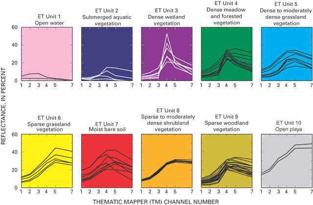
These data were released prior to the October 1, 2016 effective date for the USGS’s policy dictating the review, approval, and release of scientific data as referenced in USGS Survey Manual Chapter 502.8 Fundamental Science Practices: Review and Approval of Scientific Data for Release. The raster-based classification of evapotranspiration (ET) units is for nine major discharge areas in the Death Valley regional flow system. The ET units delineate general areas of similar vegetation and soil-moisture conditions. Classifications were derived from Landsat Thematic Mapper imagery data acquired June 13, 1992; Sept. 1, 1992; and June 21, 1989.
These data were released prior to the October 1, 2016 effective date for the USGS’s policy dictating the review, approval, and release of scientific data as referenced in USGS Survey Manual Chapter 502.8 Fundamental Science Practices: Review and Approval of Scientific Data for Release. The raster-based classification of evapotranspiration (ET) units is for nine major discharge areas in the Death Valley regional flow system. The ET units delineate general areas of similar vegetation and soil-moisture conditions. Classifications were derived from Landsat Thematic Mapper imagery data acquired June 13, 1992; Sept. 1, 1992; and June 21, 1989.

The Soil Landscapes of Canada (SLC) are a series of GIS coverages that show the major characteristics of soil and land for the whole country. SLCs were compiled at a scale of 1:1 million, and information is organized according to a uniform national set of soil and landscape criteria based on permanent natural attributes. The SLCs are based on existing soil survey maps which have been recompiled at 1:1 million scale. Each area (or polygon) on the map is described by a standard set of attributes. The full array of attributes that describe a distinct type of soil and its associated landscape, such as surface form, slope, water table depth, permafrost and lakes, is called a soil landscape. SLC polygons may contain one...

The SARP River Classification Framework provides consistent categories of ecologically relevant attributes for streams and rivers across the region at the NHD+ segment scale. The attributes that are currently available include: 1) stream size: by basin area and mean annual flow; 2) gradient: by average segment slope; 3) EPA Level 3 Ecoregion; 4) TNC Freshwater Ecoregion; and 5) Ecological Drainage Units.  For more detailed information, go to the SIFN page on the SARP website at http://www.southeastaquatics.net/sarps-programs/sifn
This dataset is a component of a complete package of products from the Connect the Connecticut project. Connect the Connecticut is a collaborative effort to identify shared priorities for conserving the Connecticut River Watershed for future generations, considering the value of fish and wildlife species and the natural ecosystems they inhabit. Click here to download the full data package, including all documentation. This dataset represents the climate response index for American Woodcock. Climate response is one of several different measures of landscape capability that reflect different decisions (or assumptions) regarding how to incorporate current versus future land use and climate changes. The climate response...
Categories: Data;
Types: ArcGIS REST Map Service,
ArcGIS Service Definition,
Citation,
Downloadable,
Map Service;
Tags: Data,
LCC Network Science Catalog,
North Atlantic Landscape Conservation Cooperative Data.gov,
change,
change,
Landscape level stratification of ecoregions in the Blue Mountain study area. Study area was defined by watershed boundaries because the pathways and distribution of anadromous fish and determined by watershed linkages and landscape characteristics.

This dataset represents the soil order from SSURGO and STATSGO soil descriptions for soil map units in the state of western Washington that lie within the North Pacific Landscape Conservation Cooperative.
This dataset represents the cumulative result of multi-season classification of land cover in the GCPO LCC geography to NatureServe Ecological Systems based on 2011 seasonal Landsat Satellite Imagery. The approach used a Random Forest algorithm and several dozen input data layers to classify land cover at a 30 m pixel resolution. The description below is taken directly from the report titled “Update of the Eastern GCPO Land Cover Database to 2011 Using a LS2SRC Approach”, by Dr. Qingmin Meng, Department of Geosciences, Mississippi State University.Random Forest classifier is based on the general decision tree approach, which has been a popular approach to multilevel and multistage decision making. Its basic idea...
Categories: Data;
Types: ArcGIS REST Map Service,
ArcGIS Service Definition,
Downloadable,
Map Service,
OGC WFS Layer,
OGC WMS Layer,
OGC WMS Service;
Tags: Data,
Data Acquisition and Development,
Data Management and Integration,
GAP,
GCPO,
This dataset represents the soil order from SSURGO and STATSGO soil descriptions for soil map units in the state of western Washington that lie within the North Pacific Landscape Conservation Cooperative.
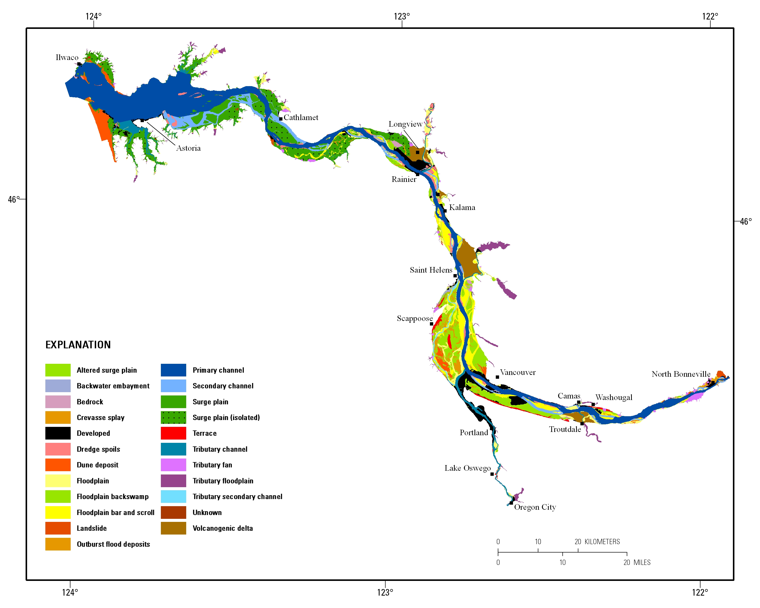
Estuarine ecosystems are controlled by a variety of processes that operate at multiple spatial and temporal scales. Understanding the hierarchical nature of these processes will aid in prioritization of restoration efforts. This hierarchical Columbia River Estuary Ecosystem Classification (henceforth "Classification") of the Columbia River estuary is a spatial database of the tidally-influenced reaches of the lower Columbia River, the tidally affected parts of its tributaries, and the landforms that make up their floodplains for the 230 kilometers between the Pacific Ocean and Bonneville Dam. This work is a collaborative effort between University of Washington School of Aquatic and Fishery Sciences (henceforth "UW"),...
|

|
