Filters: Tags: Clear Lake (X)
84 results (48ms)|
Filters
Date Range
Extensions Types Contacts
Categories Tag Types Tag Schemes
|
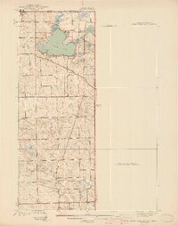
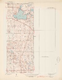
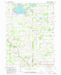
USGS Historical Quadrangle in GeoPDF.
USGS Historical Quadrangle in GeoPDF.

USGS Historical Quadrangle in GeoPDF.
Airborne magnetic data are provided here as part of the data release, "Airborne magnetic and radiometric survey, Munsungun Region, northern Maine, 2021." This website includes the processed aeromagnetic data provided in an ascii .csv file and a geoTIFF image showing the anomalous magnetic field. The contractor report is available on the parent page. Data for this survey were collected and processed by Sander Geophysics under contract with the USGS as part of the Earth Mapping Resources Initiative (Earth MRI) using a fixed wing aircraft with a magnetometer mounted in a tail stinger and a fully calibrated gamma ray spectrometer, data were collected along northwest-southeast flight lines spaced 250 meters (m) apart...
Categories: Data;
Types: Downloadable,
GeoTIFF,
Map Service,
Raster;
Tags: Allagash Lake,
Aroostook County,
Aroostook River,
Bever Brook,
Big Machias Lake,
This geologic map database is comprised of new geologic mapping, at a 1:24,000 scale, along the southern Bartlett Springs fault in the northern California Coast Ranges. The map covers an area of 258 square miles in Lake, Napa, Colusa, and Yolo counties, work was undertaken between 2016 and 2021, and supported by the USGS National Cooperative Geologic Map Program. This geodatabase contains the most up-to-date and highest resolution mapping in the region. Results and observations reported here help elucidate the geologic deformational history, as well as relationships between active older and active structures. Please consult the map pamphlet and description of map units for a detailed presentation and interpretation...
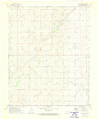
This data set contains imagery from the National Agriculture Imagery Program (NAIP). The NAIP program is administered by USDA FSA and has been established to support two main FSA strategic goals centered on agricultural production. These are, increase stewardship of America's natural resources while enhancing the environment, and to ensure commodities are procured and distributed effectively and efficiently to increase food security. The NAIP program supports these goals by acquiring and providing ortho imagery that has been collected during the agricultural growing season in the U.S. The NAIP ortho imagery is tailored to meet FSA requirements and is a fundamental tool used to support FSA farm and conservation programs....
This data set contains imagery from the National Agriculture Imagery Program (NAIP). The NAIP program is administered by USDA FSA and has been established to support two main FSA strategic goals centered on agricultural production. These are, increase stewardship of America's natural resources while enhancing the environment, and to ensure commodities are procured and distributed effectively and efficiently to increase food security. The NAIP program supports these goals by acquiring and providing ortho imagery that has been collected during the agricultural growing season in the U.S. The NAIP ortho imagery is tailored to meet FSA requirements and is a fundamental tool used to support FSA farm and conservation programs....
This data set contains imagery from the National Agriculture Imagery Program (NAIP). The NAIP program is administered by USDA FSA and has been established to support two main FSA strategic goals centered on agricultural production. These are increase stewardship of America's natural resources while enhancing the environment, and to ensure commodities are procured and distributed effectively and efficiently to increase food security. The NAIP program supports these goals by acquiring and providing ortho imagery that has been collected during the agricultural growing season in the U.S. The NAIP ortho imagery is tailored to meet FSA requirements and is a fundamental tool used to support FSA farm and conservation programs....
This data set contains imagery from the National Agriculture Imagery Program (NAIP). The NAIP program is administered by USDA FSA and has been established to support two main FSA strategic goals centered on agricultural production. These are, increase stewardship of America's natural resources while enhancing the environment, and to ensure commodities are procured and distributed effectively and efficiently to increase food security. The NAIP program supports these goals by acquiring and providing ortho imagery that has been collected during the agricultural growing season in the U.S. The NAIP ortho imagery is tailored to meet FSA requirements and is a fundamental tool used to support FSA farm and conservation programs....
The dataset includes water temperature and atmospheric pressure data collected from selected key tributaries Clear Lake, Lake County, California, used for spawning by the Clear Lake Hitch (Lavinia exilicauda chi): Kelsey Creek, Siegler Creek, Middle Creek, Adobe Creek, and Cole Creek. Data were collected with ONSET HOBO Model U20L-002 loggers.
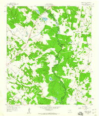
USGS Historical Quadrangle in GeoPDF.
This geologic map database is a reproduction of U.S. Geological Survey Miscellaneous Investigations Map I–2362: “Geologic Map and Structure Sections of the Clear Lake Volcanics, Northern California” (Hearn, Donnelly-Nolan, and Goff, 1995). The database consists of a geologic map, three structural cross sections and a table of petrographic data for each map unit by mineral type, abundance, and size. The Clear Lake Volcanics are in the California Coast Ranges about 150 km north of San Francisco. This Quaternary volcanic field has erupted intermittently since 2.1 million years ago. This volcanic field is considered a high-threat volcanic system (Ewert and others, 2005). The adjacent Geysers geothermal field, the largest...
USGS Historical Quadrangle in GeoPDF.
Field data for fishes sampled using bottom and surface gill nets during daylight hours in Clear Lake, California, USA. This data release includes all measured environmental parameters and fish taxa included in the analysis. First posted - December 20, 2018 (available from author) Revision - November 26, 2019 (available from author) Revision - January 21, 2022 (available from author) Revision - October 11, 2022 (available from author) Revision - September 21, 2023 (current version)
This data set contains imagery from the National Agriculture Imagery Program (NAIP). The NAIP program is administered by USDA FSA and has been established to support two main FSA strategic goals centered on agricultural production. These are, increase stewardship of America's natural resources while enhancing the environment, and to ensure commodities are procured and distributed effectively and efficiently to increase food security. The NAIP program supports these goals by acquiring and providing ortho imagery that has been collected during the agricultural growing season in the U.S. The NAIP ortho imagery is tailored to meet FSA requirements and is a fundamental tool used to support FSA farm and conservation programs....
This data set contains imagery from the National Agriculture Imagery Program (NAIP). The NAIP program is administered by USDA FSA and has been established to support two main FSA strategic goals centered on agricultural production. These are increase stewardship of America's natural resources while enhancing the environment, and to ensure commodities are procured and distributed effectively and efficiently to increase food security. The NAIP program supports these goals by acquiring and providing ortho imagery that has been collected during the agricultural growing season in the U.S. The NAIP ortho imagery is tailored to meet FSA requirements and is a fundamental tool used to support FSA farm and conservation programs....
This data set contains imagery from the National Agriculture Imagery Program (NAIP). The NAIP program is administered by USDA FSA and has been established to support two main FSA strategic goals centered on agricultural production. These are increase stewardship of America's natural resources while enhancing the environment, and to ensure commodities are procured and distributed effectively and efficiently to increase food security. The NAIP program supports these goals by acquiring and providing ortho imagery that has been collected during the agricultural growing season in the U.S. The NAIP ortho imagery is tailored to meet FSA requirements and is a fundamental tool used to support FSA farm and conservation programs....
The dataset includes four seperate files of data for a project that examined the strontium isotopic composition of otoliths of Clear Lake Hitch. Otoliths examined in this study were from randomly-sampled individual Clear Lake Hitch that recruited into the adult population in Clear Lake. The fish were collected in June and July 2017. Strontium isotopic composition (87Sr/86Sr ) in otoliths was determined with a multicollector LA-ICP mass spectrometer (LA-ICMPS; Nu Plasma HR, Nu Instrument, Inc.) interfaced with a Nd : YAG 213-nm laser (New Wave Research UP213) at the University of California, Davis. Fish capture and size data are in the file Clear Lake Hitch Otolith Data_FISH. Otolith increment data are in the file...
Categories: Data;
Tags: Aquatic Biology,
California,
Clear Lake,
Clear Lake Hitch (Lavinia exilicauda chi),
Ecology,
This dataset includes data from isotopic analysis of eye and muscle tissue from fish collected in Clear Lake, Lake County, California during June and July 2017. This data release includes all biological measurements and fish taxa included in the analysis.
USGS Historical Quadrangle in GeoPDF.
|

|
