Filters: Tags: Climate change (X)
4,208 results (6ms)|
Filters
|
These data are netcdf files of the projected timing of the onset of thermal stress severe enough (>8 Degree Heating Weeks) to cause coral bleaching 2x per decade and 10x per decade (annual) under emissions scenarios RCP8.5 and RCP4.5. The projected timing (a year between 2006 and 2100) is the data value. Values are only shown for the ~60,000 four-km pixels where coral reefs are known to occur.
Categories: Data;
Types: Citation,
NetCDF OPeNDAP Service;
Tags: Climate change,
Coral bleaching,
Coral reefs,
Global,
Marine ecology,
This metadata record describes the materials contained in stake folder 696. Stake 696 is located at latitude 36.39889, longitude -112.63056. This location was photographed in the following years: 1872, 1968 and 1972. The materials associated with this item include original best quality images from each repeat date (preserved as digitized film images or in some cases digitized print photographs, depending on availability), scanned film envelopes with camera metadata, records of repeat photography sheets, and all field notes and/or camera notes associated with this stake. All attachments follow the following naming convention: stake_date_material_type_Kanab. Some stakes will have multiple materials from one repeat...
Types: Citation;
Tags: Albion camera,
Colorado River,
Dallmeyer lenses,
Kanab Creek,
Southwestern United States,
This metadata record describes the materials contained in stake folder 713. Stake 713 is located at latitude 36.42478, longitude -112.63036. This location was photographed in the following years: 1872 and 1968. The materials associated with this item include original best quality images from each repeat date (preserved as digitized film images or in some cases digitized print photographs, depending on availability), scanned film envelopes with camera metadata, records of repeat photography sheets, and all field notes and/or camera notes associated with this stake. All attachments follow the following naming convention: stake_date_material_type_Kanab. Some stakes will have multiple materials from one repeat date...
Types: Citation;
Tags: Albion camera,
Colorado River,
Dallmeyer lenses,
Kanab Creek,
Southwestern United States,
This metadata record describes the materials contained in stake folder 2595. Stake 2595 is located at latitude 36.392, longitude -112.629. This location was photographed in the following years: 1942 and 1993. The materials associated with this item include original best quality images from each repeat date (preserved as digitized film images or in some cases digitized print photographs, depending on availability), scanned film envelopes with camera metadata, records of repeat photography sheets, and all field notes and/or camera notes associated with this stake. All attachments follow the following naming convention: stake_date_material_type_Kanab. Some stakes will have multiple materials from one repeat date (e.g.,...
Types: Citation;
Tags: Albion camera,
Colorado River,
Dallmeyer lenses,
Kanab Creek,
Southwestern United States,
This metadata record describes the materials contained in stake folder 1506. Stake 1506 is located at latitude 36.38585, longitude -112.63963. This location was photographed in the following years: 1909 (no physical image) and 1990. The materials associated with this item include original best quality images from each repeat date (preserved as digitized film images or in some cases digitized print photographs, depending on availability), scanned film envelopes with camera metadata, records of repeat photography sheets, and all field notes and/or camera notes associated with this stake. All attachments follow the following naming convention: stake_date_material_type_Kanab. Some stakes will have multiple materials...
Types: Citation;
Tags: Albion camera,
Colorado River,
Dallmeyer lenses,
Kanab Creek,
Southwestern United States,
This data table contains mean decomposition rates and mean carbon:nitrogen ratios for different litter types buried in 7 marshes during 2015. Note that C:N data are repeated for low and high marsh areas at each site in the table. These data support the following publication: Janousek, C.N., Buffington, K.J., Guntenspergen, G.R. et al. Ecosystems (2017). doi:10.1007/s10021-017-0111-6. http://link.springer.com/article/10.1007/s10021-017-0111-6
Categories: Data;
Types: Citation;
Tags: Deschampsia cespitosa,
Distichlis spicata,
Pacific coast,
Salicornia pacifica,
carbon cycling,
This data set contains decomposition rates for litter of Salicornia pacifica, Distichlis spicata, and Deschampsia cespitosa buried at 7 tidal marsh sites in 2015. Sediment organic matter values were collected at a subset of sites. These data support the following publication: Janousek, C.N., Buffington, K.J., Guntenspergen, G.R. et al. Ecosystems (2017). doi:10.1007/s10021-017-0111-6. http://link.springer.com/article/10.1007/s10021-017-0111-6
Categories: Data;
Types: Citation;
Tags: Deschampsia cespitosa,
Distichlis spicata,
Pacific coast,
Salicornia pacifica,
carbon cycling,

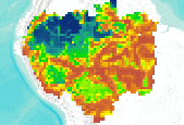
The integrity of Amazon forests are currently threatened by climate change, deforestation, and fire. However, it is unclear how these agents of change interact over large spatial and temporal domains and reducing this uncertainty is important for projecting changes in carbon stocks and species biogeography, and could better inform continental scale conservation programs. With this in mind, aboveground biomass and tree cover data were produced using the dynamic global vegetation model, LPJmL, with 9 different global climate models (using the SRES A2 emissions storyline) and 2 different deforestation scenarios (from Soares et al.). The existing fire module was modified to include 'escaped fire' associated with deforestation,...

The integrity of Amazon forests are currently threatened by climate change, deforestation, and fire. However, it is unclear how these agents of change interact over large spatial and temporal domains and reducing this uncertainty is important for projecting changes in carbon stocks and species biogeography, and could better inform continental scale conservation programs. With this in mind, aboveground biomass and tree cover data were produced using the dynamic global vegetation model, LPJmL, with 9 different global climate models (using the SRES A2 emissions storyline) and 2 different deforestation scenarios (from Soares et al.). The existing fire module was modified to include 'escaped fire' associated with deforestation,...

This dataset represents actual and predicted suitable habitat for Liriodendron tuliperfia (yellow-poplar, species code 621) in the Eastern United States as measured by importance value based on data obtained from the Forest Inventory and Analysis (FIA) project, current climate conditions, and future climate projections. This summary unit of this dataset is a 20 by 20 kilometer cell. The actual importance value (IV) was calculated based on the number of stems and basal area of a given tree species relative to other tree species on a plot using about 100,000 FIA plots (representing nearly 3 million tree records) in the 37 states within the United States east of the 100th meridian. These importance values were summarized...

MC1 is a dynamic vegetation model for estimating the distribution of vegetation and associated ecosystem fluxes of carbon, nutrients, and water. It was created to assess the potential impacts of global climate change on ecosystem structure and function at a wide range of spatial scales from landscape to global. The model incorporates transient dynamics to make predictions about the patterns of ecological change. MC1 was created by combining physiologically based biogeographic rules defined in the MAPSS model with a modified version of the biogeochemical model, CENTURY. MC1 includes a fire module, MCFIRE, that mechanistically simulates the occurrence and impacts of fire events. Climate input data sources for this...

The integrity of Amazon forests are currently threatened by climate change, deforestation, and fire. However, it is unclear how these agents of change interact over large spatial and temporal domains and reducing this uncertainty is important for projecting changes in carbon stocks and species biogeography, and could better inform continental scale conservation programs. With this in mind, above ground biomass and tree cover data were produced using the dynamic global vegetation model, LPJmL, with 9 different global climate models (using the SRES A2 emissions storyline) and 2 different deforestation scenarios (from Soares et al.). The existing fire module was modified to include 'escaped fire' associated with deforestation,...

The integrity of Amazon forests are currently threatened by climate change, deforestation, and fire. However, it is unclear how these agents of change interact over large spatial and temporal domains and reducing this uncertainty is important for projecting changes in carbon stocks and species biogeography, and could better inform continental scale conservation programs. With this in mind, above ground biomass and tree cover data were produced using the dynamic global vegetation model, LPJmL, with 9 different global climate models (using the SRES A2 emissions storyline) and 2 different deforestation scenarios (from Soares et al.). The existing fire module was modified to include 'escaped fire' associated with deforestation,...

The integrity of Amazon forests are currently threatened by climate change, deforestation, and fire. However, it is unclear how these agents of change interact over large spatial and temporal domains and reducing this uncertainty is important for projecting changes in carbon stocks and species biogeography, and could better inform continental scale conservation programs. With this in mind, above ground biomass and tree cover data were produced using the dynamic global vegetation model, LPJmL, with 9 different global climate models (using the SRES A2 emissions storyline) and 2 different deforestation scenarios (from Soares et al.). The existing fire module was modified to include 'escaped fire' associated with deforestation,...

The integrity of Amazon forests are currently threatened by climate change, deforestation, and fire. However, it is unclear how these agents of change interact over large spatial and temporal domains and reducing this uncertainty is important for projecting changes in carbon stocks and species biogeography, and could better inform continental scale conservation programs. With this in mind, aboveground biomass and tree cover data were produced using the dynamic global vegetation model, LPJmL, with 9 different global climate models (using the SRES A2 emissions storyline) and 2 different deforestation scenarios (from Soares et al.). The existing fire module was modified to include 'escaped fire' associated with deforestation,...

The integrity of Amazon forests are currently threatened by climate change, deforestation, and fire. However, it is unclear how these agents of change interact over large spatial and temporal domains and reducing this uncertainty is important for projecting changes in carbon stocks and species biogeography, and could better inform continental scale conservation programs. With this in mind, aboveground biomass and tree cover data were produced using the dynamic global vegetation model, LPJmL, with 9 different global climate models (using the SRES A2 emissions storyline) and 2 different deforestation scenarios (from Soares et al.). The existing fire module was modified to include 'escaped fire' associated with deforestation,...

The integrity of Amazon forests are currently threatened by climate change, deforestation, and fire. However, it is unclear how these agents of change interact over large spatial and temporal domains and reducing this uncertainty is important for projecting changes in carbon stocks and species biogeography, and could better inform continental scale conservation programs. With this in mind, aboveground biomass and tree cover data were produced using the dynamic global vegetation model, LPJmL, with 9 different global climate models (using the SRES A2 emissions storyline) and 2 different deforestation scenarios (from Soares et al.). The existing fire module was modified to include 'escaped fire' associated with deforestation,...

The integrity of Amazon forests are currently threatened by climate change, deforestation, and fire. However, it is unclear how these agents of change interact over large spatial and temporal domains and reducing this uncertainty is important for projecting changes in carbon stocks and species biogeography, and could better inform continental scale conservation programs. With this in mind, aboveground biomass and tree cover data were produced using the dynamic global vegetation model, LPJmL, with 9 different global climate models (using the SRES A2 emissions storyline) and 2 different deforestation scenarios (from Soares et al.). The existing fire module was modified to include 'escaped fire' associated with deforestation,...

The integrity of Amazon forests are currently threatened by climate change, deforestation, and fire. However, it is unclear how these agents of change interact over large spatial and temporal domains and reducing this uncertainty is important for projecting changes in carbon stocks and species biogeography, and could better inform continental scale conservation programs. With this in mind, aboveground biomass and tree cover data were produced using the dynamic global vegetation model, LPJmL, with 9 different global climate models (using the SRES A2 emissions storyline) and 2 different deforestation scenarios (from Soares et al.). The existing fire module was modified to include 'escaped fire' associated with deforestation,...
The integrity of Amazon forests are currently threatened by climate change, deforestation, and fire. However, it is unclear how these agents of change interact over large spatial and temporal domains and reducing this uncertainty is important for projecting changes in carbon stocks and species biogeography, and could better inform continental scale conservation programs. With this in mind, aboveground biomass and tree cover data were produced using the dynamic global vegetation model, LPJmL, with 9 different global climate models (using the SRES A2 emissions storyline) and 2 different deforestation scenarios (from Soares et al.). The existing fire module was modified to include 'escaped fire' associated with deforestation,...
|

|
