Filters: Tags: Columbia Plateau Ecoregion (X)
47 results (28ms)|
Filters
Date Range
Extensions Types
Contacts
Categories Tag Types
|

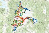
For a description of each map layer, select the Details tab, then select a Layer Name. This GIS dataset is part of a suite of wildlife habitat connectivity data produced by the Washington Wildlife Habitat Connectivity Working Group (WHCWG). The WHCWG is a voluntary public-private partnership between state and federal agencies, universities, tribes, and non-governmental organizations. The WHCWG is co-led by the Washington Department of Fish and Wildlife (WDFW) and the Washington Department of Transportation (WSDOT). This dataset quantifies current wildlife habitat connectivity patterns for the Columbia Plateau Ecoregion in Washington, Oregon, and Idaho. Available WHCWG raster data include model base layers, resistance,...

For a description of each map layer, select the Details tab, then select a Layer Name. This GIS dataset is part of a suite of wildlife habitat connectivity data produced by the Washington Wildlife Habitat Connectivity Working Group (WHCWG). The WHCWG is a voluntary public-private partnership between state and federal agencies, universities, tribes, and non-governmental organizations. The WHCWG is co-led by the Washington Department of Fish and Wildlife (WDFW) and the Washington Department of Transportation (WSDOT). This dataset quantifies current wildlife habitat connectivity patterns for the Columbia Plateau Ecoregion in Washington, Oregon, and Idaho. Available WHCWG raster data include model base layers, resistance,...

For a description of each map layer, select the Details tab, then select a Layer Name. This GIS dataset is part of a suite of wildlife habitat connectivity data produced by the Washington Wildlife Habitat Connectivity Working Group (WHCWG). The WHCWG is a voluntary public-private partnership between state and federal agencies, universities, tribes, and non-governmental organizations. The WHCWG is co-led by the Washington Department of Fish and Wildlife (WDFW) and the Washington Department of Transportation (WSDOT). This dataset quantifies current wildlife habitat connectivity patterns for the Columbia Plateau Ecoregion in Washington, Oregon, and Idaho. Available WHCWG raster data include model base layers, resistance,...
This GIS dataset is part of a suite of wildlife habitat connectivity data produced by the Washington Wildlife Habitat Connectivity Working Group (WHCWG). The WHCWG is a voluntary public-private partnership between state and federal agencies, universities, tribes, and non-governmental organizations. The WHCWG is co-led by the Washington Department of Fish and Wildlife (WDFW) and the Washington Department of Transportation (WSDOT). This dataset quantifies current wildlife habitat connectivity patterns for the Columbia Plateau Ecoregion in Washington, Oregon, and Idaho. Available WHCWG raster data include model base layers, resistance, habitat, cost-weighted distance, and landscape integrity. Grid cell size is 90 m...
This GIS dataset is part of a suite of wildlife habitat connectivity data produced by the Washington Wildlife Habitat Connectivity Working Group (WHCWG). The WHCWG is a voluntary public-private partnership between state and federal agencies, universities, tribes, and non-governmental organizations. The WHCWG is co-led by the Washington Department of Fish and Wildlife (WDFW) and the Washington Department of Transportation (WSDOT). This dataset quantifies current wildlife habitat connectivity patterns for the Columbia Plateau Ecoregion in Washington, Oregon, and Idaho. Available WHCWG raster data include model base layers, resistance, habitat, cost-weighted distance, and landscape integrity. Grid cell size is 90 m...
Categories: Data;
Types: ArcGIS Map Package,
ArcGIS REST Map Service,
ArcGIS Service Definition,
Downloadable,
Map Service;
Tags: columbia plateau ecoregion,
core area,
cost-weighted distance ,
focal species,
habitat concentration area ,
For a description of each map layer, select the Details tab, then select a Layer Name.This GIS dataset is part of a suite of wildlife habitat connectivity data produced by the Washington Wildlife Habitat Connectivity Working Group (WHCWG). The WHCWG is a voluntary public-private partnership between state and federal agencies, universities, tribes, and non-governmental organizations. The WHCWG is co-led by the Washington Department of Fish and Wildlife (WDFW) and the Washington Department of Transportation (WSDOT). This dataset quantifies current wildlife habitat connectivity patterns for the Columbia Plateau Ecoregion in Washington, Oregon, and Idaho. Available WHCWG raster data include model base layers, resistance,...

For a description of each map layer, select the Details tab, then select a Layer Name. This GIS dataset is part of a suite of wildlife habitat connectivity data produced by the Washington Wildlife Habitat Connectivity Working Group (WHCWG). The WHCWG is a voluntary public-private partnership between state and federal agencies, universities, tribes, and non-governmental organizations. The WHCWG is co-led by the Washington Department of Fish and Wildlife (WDFW) and the Washington Department of Transportation (WSDOT). This dataset quantifies current wildlife habitat connectivity patterns for the Columbia Plateau Ecoregion in Washington, Oregon, and Idaho. Available WHCWG raster data include model base layers, resistance,...
This GIS dataset is part of a suite of wildlife habitat connectivity data produced by the Washington Wildlife Habitat Connectivity Working Group (WHCWG). The WHCWG is a voluntary public-private partnership between state and federal agencies, universities, tribes, and non-governmental organizations. The WHCWG is co-led by the Washington Department of Fish and Wildlife (WDFW) and the Washington Department of Transportation (WSDOT). This dataset quantifies current wildlife habitat connectivity patterns for the Columbia Plateau Ecoregion in Washington, Oregon, and Idaho. Available WHCWG raster data include model base layers, resistance, habitat, cost-weighted distance, and landscape integrity. Grid cell size is 90 m...
Categories: Data;
Types: ArcGIS Map Package,
ArcGIS REST Map Service,
ArcGIS Service Definition,
Downloadable,
Map Service;
Tags: Idaho,
Oregon,
Pacific Northwest,
USA,
Washington,
This GIS dataset is part of a suite of wildlife habitat connectivity data produced by the Washington Wildlife Habitat Connectivity Working Group (WHCWG). The WHCWG is a voluntary public-private partnership between state and federal agencies, universities, tribes, and non-governmental organizations. The WHCWG is co-led by the Washington Department of Fish and Wildlife (WDFW) and the Washington Department of Transportation (WSDOT). This dataset quantifies current wildlife habitat connectivity patterns for the Columbia Plateau Ecoregion in Washington, Oregon, and Idaho. Available WHCWG raster data include model base layers, resistance, habitat, cost-weighted distance, and landscape integrity. Grid cell size is 90 m...
Categories: Data;
Types: ArcGIS Map Package,
ArcGIS REST Map Service,
Downloadable,
Map Service;
Tags: columbia plateau ecoregion,
core area,
cost-weighted distance,
focal species,
habitat concentration area,

For a description of each map layer, select the Details tab, then select a Layer Name. This GIS dataset is part of a suite of wildlife habitat connectivity data produced by the Washington Wildlife Habitat Connectivity Working Group (WHCWG). The WHCWG is a voluntary public-private partnership between state and federal agencies, universities, tribes, and non-governmental organizations. The WHCWG is co-led by the Washington Department of Fish and Wildlife (WDFW) and the Washington Department of Transportation (WSDOT). This dataset quantifies current wildlife habitat connectivity patterns for the Columbia Plateau Ecoregion in Washington, Oregon, and Idaho. Available WHCWG raster data include model base layers, resistance,...
This raster combines linkages developed from four landscape integrity-derived resistance surfaces: linear, low sensitivity, medium sensitivity, and high sensitivity. See Section 2.5.2 WHCWG (2012) for additional information pertaining to development of the four landscape integrity-derived resistance rasters. Adjacent core areas within 100 km Euclidean distance of one another were connected. This GIS dataset is part of a suite of wildlife habitat connectivity data produced by the Washington Wildlife Habitat Connectivity Working Group (WHCWG). The WHCWG is a voluntary public-private partnership between state and federal agencies, universities, tribes, and non-governmental organizations. The WHCWG is co-led by the...
Categories: Data;
Types: Downloadable,
Map Service,
Raster;
Tags: British Columbia,
Columbia Plateau Ecoregion,
Data Visualization & Tools,
Idaho,
Landscapes,
This project will integrate the shared priorities developed by the Arid Lands Initiative (ALI) in the Columbia Plateau ecoregion into implementation mechanisms of existing and new ALI partners. The project will finalize the ALIs comprehensive strategy by assessing and agreeing on which partners are best positioned to implement which priority actions in which priority areas, integrate these priorities into existing partner work, identify gaps that new partners need to be engaged to address, design 1-2 ALI projects for collaborative implementation, and track and adapt the overall implementation efforts. This project will not only allow the ALI to successfully transition from planning to coordinated action, but will...
Categories: Data,
Project;
Types: Map Service,
OGC WFS Layer,
OGC WMS Layer,
OGC WMS Service;
Tags: Aquatic Connectivity,
CA-1,
California,
California,
Climate Change,
This GIS dataset is part of a suite of wildlife habitat connectivity data produced by the Washington Wildlife Habitat Connectivity Working Group (WHCWG). The WHCWG is a voluntary public-private partnership between state and federal agencies, universities, tribes, and non-governmental organizations. The WHCWG is co-led by the Washington Department of Fish and Wildlife (WDFW) and the Washington Department of Transportation (WSDOT). This dataset quantifies current wildlife habitat connectivity patterns for the Columbia Plateau Ecoregion in Washington, Oregon, and Idaho. Available WHCWG raster data include model base layers, resistance, habitat, cost-weighted distance, and landscape integrity. Grid cell size is 90 m...
This GIS dataset is part of a suite of wildlife habitat connectivity data produced by the Washington Wildlife Habitat Connectivity Working Group (WHCWG). The WHCWG is a voluntary public-private partnership between state and federal agencies, universities, tribes, and non-governmental organizations. The WHCWG is co-led by the Washington Department of Fish and Wildlife (WDFW) and the Washington Department of Transportation (WSDOT). This dataset quantifies current wildlife habitat connectivity patterns for the Columbia Plateau Ecoregion in Washington, Oregon, and Idaho. Available WHCWG raster data include model base layers, resistance, habitat, cost-weighted distance, and landscape integrity. Grid cell size is 90 m...
This GIS dataset is part of a suite of wildlife habitat connectivity data produced by the Washington Wildlife Habitat Connectivity Working Group (WHCWG). The WHCWG is a voluntary public-private partnership between state and federal agencies, universities, tribes, and non-governmental organizations. The WHCWG is co-led by the Washington Department of Fish and Wildlife (WDFW) and the Washington Department of Transportation (WSDOT). This dataset quantifies current wildlife habitat connectivity patterns for the Columbia Plateau Ecoregion in Washington, Oregon, and Idaho. Available WHCWG raster data include model base layers, resistance, habitat, cost-weighted distance, and landscape integrity. Grid cell size is 90 m...

This GIS dataset is part of a suite of wildlife habitat connectivity data produced by the Washington Wildlife Habitat Connectivity Working Group (WHCWG). The WHCWG is a voluntary public-private partnership between state and federal agencies, universities, tribes, and non-governmental organizations. The WHCWG is co-led by the Washington Department of Fish and Wildlife (WDFW) and the Washington Department of Transportation (WSDOT). This dataset quantifies current wildlife habitat connectivity patterns for the Columbia Plateau Ecoregion in Washington, Oregon, and Idaho. Available WHCWG raster data include model base layers, resistance, habitat, cost-weighted distance, and landscape integrity. Grid cell size is 90 m...

For a description of each map layer, select the Details tab, then select a Layer Name. This GIS dataset is part of a suite of wildlife habitat connectivity data produced by the Washington Wildlife Habitat Connectivity Working Group (WHCWG). The WHCWG is a voluntary public-private partnership between state and federal agencies, universities, tribes, and non-governmental organizations. The WHCWG is co-led by the Washington Department of Fish and Wildlife (WDFW) and the Washington Department of Transportation (WSDOT). This dataset quantifies current wildlife habitat connectivity patterns for the Columbia Plateau Ecoregion in Washington, Oregon, and Idaho. Available WHCWG raster data include model base layers, resistance,...
For a description of each map layer, select the Details tab, then select a Layer Name. This GIS dataset is part of a suite of wildlife habitat connectivity data produced by the Washington Wildlife Habitat Connectivity Working Group (WHCWG). The WHCWG is a voluntary public-private partnership between state and federal agencies, universities, tribes, and non-governmental organizations. The WHCWG is co-led by the Washington Department of Fish and Wildlife (WDFW) and the Washington Department of Transportation (WSDOT). This dataset quantifies current wildlife habitat connectivity patterns for the Columbia Plateau Ecoregion in Washington, Oregon, and Idaho. Available WHCWG raster data include model base layers, resistance,...
|

|
