Filters: Tags: Columbia River (X) > partyWithName: U.S. Geological Survey (X)
19 results (52ms)|
Filters
Date Range
Extensions Types
Contacts
Categories Tag Types Tag Schemes |

These data were released prior to the October 1, 2016 effective date for the USGS’s policy dictating the review, approval, and release of scientific data as referenced in USGS Survey Manual Chapter 502.8 Fundamental Science Practices: Review and Approval of Scientific Data for Release. Estuarine ecosystems are controlled by a variety of processes that operate at multiple spatial and temporal scales. Understanding the hierarchical nature of these processes will aid in prioritization of restoration efforts. This hierarchical Columbia River Estuary Ecosystem Classification (henceforth "Classification") of the Columbia River estuary is a spatial database of the tidally-influenced reaches of the lower Columbia River,...

These data were released prior to the October 1, 2016 effective date for the USGS’s policy dictating the review, approval, and release of scientific data as referenced in USGS Survey Manual Chapter 502.8 Fundamental Science Practices: Review and Approval of Scientific Data for Release. Estuarine ecosystems are controlled by a variety of processes that operate at multiple spatial and temporal scales. Understanding the hierarchical nature of these processes will aid in prioritization of restoration efforts. This hierarchical Columbia River Estuary Ecosystem Classification (henceforth "Classification") of the Columbia River estuary is a spatial database of the tidally-influenced reaches of the lower Columbia River,...
Sandy ocean beaches are a popular recreational destination, often surrounded by communities containing valuable real estate. Development is on the rise despite the fact that coastal infrastructure is subjected to flooding and erosion. As a result, there is an increased demand for accurate information regarding past and present shoreline changes. To meet these national needs, the Coastal and Marine Geology Program of the U.S. Geological Survey (USGS) is compiling existing reliable historical shoreline data along open-ocean sandy shores of the conterminous United States and parts of Alaska and Hawaii under the National Assessment of Shoreline Change project.There is no widely accepted standard for analyzing shoreline...
Categories: Data;
Types: ArcGIS REST Map Service,
ArcGIS Service Definition,
Downloadable,
Map Service;
Tags: Accretion,
CMGP,
Coastal and Marine Geology Program,
Columbia River,
DSAS,

These data were released prior to the October 1, 2016 effective date for the USGS’s policy dictating the review, approval, and release of scientific data as referenced in USGS Survey Manual Chapter 502.8 Fundamental Science Practices: Review and Approval of Scientific Data for Release. Estuarine ecosystems are controlled by a variety of processes that operate at multiple spatial and temporal scales. Understanding the hierarchical nature of these processes will aid in prioritization of restoration efforts. This hierarchical Columbia River Estuary Ecosystem Classification (henceforth "Classification") of the Columbia River estuary is a spatial database of the tidally-influenced reaches of the lower Columbia River,...
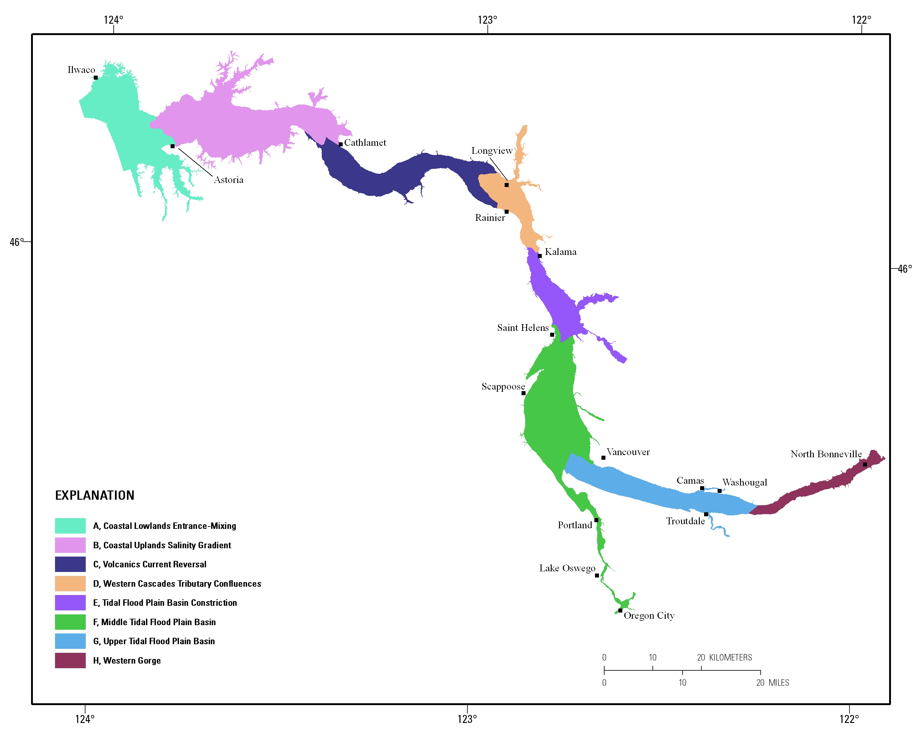
Estuarine ecosystems are controlled by a variety of processes that operate at multiple spatial and temporal scales. Understanding the hierarchical nature of these processes will aid in prioritization of restoration efforts. This hierarchical Columbia River Estuary Ecosystem Classification (henceforth "Classification") of the Columbia River estuary is a spatial database of the tidally-influenced reaches of the lower Columbia River, the tidally affected parts of its tributaries, and the landforms that make up their floodplains for the 230 kilometers between the Pacific Ocean and Bonneville Dam. This work is a collaborative effort between University of Washington School of Aquatic and Fishery Sciences (henceforth "UW"),...
This portion of the USGS data release presents topography data collected during surveys performed in the Columbia River littoral cell, Washington and Oregon, in 2022 (USGS Field Activity Number 2022-641-FA). Topographic profiles were collected by walking along survey lines with global navigation satellite system (GNSS) receivers mounted on backpacks. Prior to data collection, vertical distances between the GNSS antennas and the ground were measured using a tape measure. Hand-held data collectors were used to log raw data and display navigational information allowing surveyors to navigate survey lines spaced at 100- to 1000-m intervals along the beach. Profiles were surveyed from the landward edge of the study area...
Categories: Data;
Types: Map Service,
OGC WFS Layer,
OGC WMS Layer,
OGC WMS Service;
Tags: Bathymetry and Elevation,
CMHRP,
Clatsop County,
Coastal and Marine Hazards and Resources Program,
Columbia River,

These data were released prior to the October 1, 2016 effective date for the USGS’s policy dictating the review, approval, and release of scientific data as referenced in USGS Survey Manual Chapter 502.8 Fundamental Science Practices: Review and Approval of Scientific Data for Release. A digital representation of the watersheds of 43 sites on large river systems sampled by the National Stream Quality Accounting Network (NASQAN) of the U. S. Geological Survey (USGS) in 2000 was created primarily from 1:250,000 hydrologic units(HUCs) in the United States. Watershed information from Canada and Mexico was incorporated to complete the areas draining to the sampling sites from outside the United States. The sampled rivers...
This portion of the USGS data release presents topography data collected during surveys performed in the Columbia River littoral cell, Washington and Oregon, in 2023 (USGS Field Activity Number 2023-644-FA). Topographic profiles were collected by walking along survey lines with global navigation satellite system (GNSS) receivers mounted on backpacks. Prior to data collection, vertical distances between the GNSS antennas and the ground were measured using a tape measure. Hand-held data collectors were used to log raw data and display navigational information allowing surveyors to navigate survey lines spaced at 100- to 1000-m intervals along the beach. Profiles were surveyed from the landward edge of the study area...
Categories: Data;
Types: Map Service,
OGC WFS Layer,
OGC WMS Layer,
OGC WMS Service;
Tags: Bathymetry and Elevation,
CMHRP,
Clatsop County,
Coastal and Marine Hazards and Resources Program,
Columbia River,
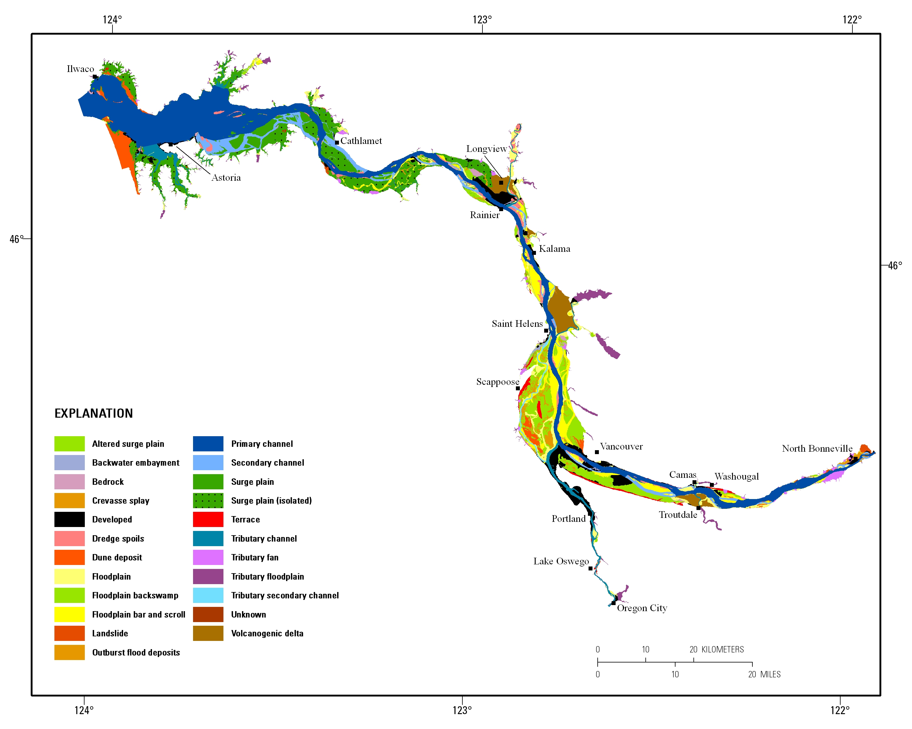
Estuarine ecosystems are controlled by a variety of processes that operate at multiple spatial and temporal scales. Understanding the hierarchical nature of these processes will aid in prioritization of restoration efforts. This hierarchical Columbia River Estuary Ecosystem Classification (henceforth "Classification") of the Columbia River estuary is a spatial database of the tidally-influenced reaches of the lower Columbia River, the tidally affected parts of its tributaries, and the landforms that make up their floodplains for the 230 kilometers between the Pacific Ocean and Bonneville Dam. This work is a collaborative effort between University of Washington School of Aquatic and Fishery Sciences (henceforth "UW"),...
This portion of the USGS data release presents bathymetry data collected during surveys performed in the Columbia River littoral cell and mouth of the Columbia River, Washington and Oregon, in 2023 (USGS Field Activity Number 2023-644-FA). Bathymetry data were collected using four personal watercraft (PWCs) equipped with single-beam sonar systems and global navigation satellite system (GNSS) receivers. The sonar systems consisted of either an Odom Echotrac CV-100 or CEE Hydrosystems Ceescope single-beam echosounder and 200 kHz transducer with a 9-degree beam angle. Raw acoustic backscatter returns were digitized by the echosounder with a vertical resolution of 1.25 cm. Depths from the echosounders were computed...
Categories: Data;
Types: Map Service,
OGC WFS Layer,
OGC WMS Layer,
OGC WMS Service;
Tags: Bathymetry and Elevation,
CMHRP,
Clatsop County,
Coastal and Marine Hazards and Resources Program,
Columbia River,

These data were released prior to the October 1, 2016 effective date for the USGS’s policy dictating the review, approval, and release of scientific data as referenced in USGS Survey Manual Chapter 502.8 Fundamental Science Practices: Review and Approval of Scientific Data for Release. Estuarine ecosystems are controlled by a variety of processes that operate at multiple spatial and temporal scales. Understanding the hierarchical nature of these processes will aid in prioritization of restoration efforts. This hierarchical Columbia River Estuary Ecosystem Classification (henceforth "Classification") of the Columbia River estuary is a spatial database of the tidally-influenced reaches of the lower Columbia River,...
Categories: pre-SM502.8;
Tags: Clackamas County,
Clark County,
Clatsop County,
Columbia County,
Columbia River,
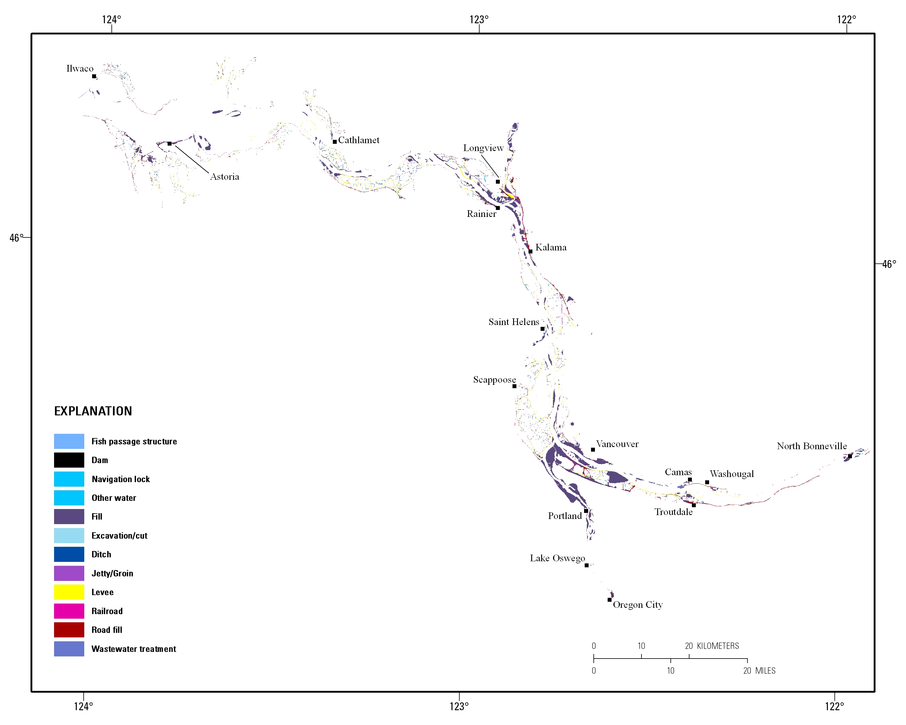
Estuarine ecosystems are controlled by a variety of processes that operate at multiple spatial and temporal scales. Understanding the hierarchical nature of these processes will aid in prioritization of restoration efforts. This hierarchical Columbia River Estuary Ecosystem Classification (henceforth "Classification") of the Columbia River estuary is a spatial database of the tidally-influenced reaches of the lower Columbia River, the tidally affected parts of its tributaries, and the landforms that make up their floodplains for the 230 kilometers between the Pacific Ocean and Bonneville Dam. This work is a collaborative effort between University of Washington School of Aquatic and Fishery Sciences (henceforth "UW"),...
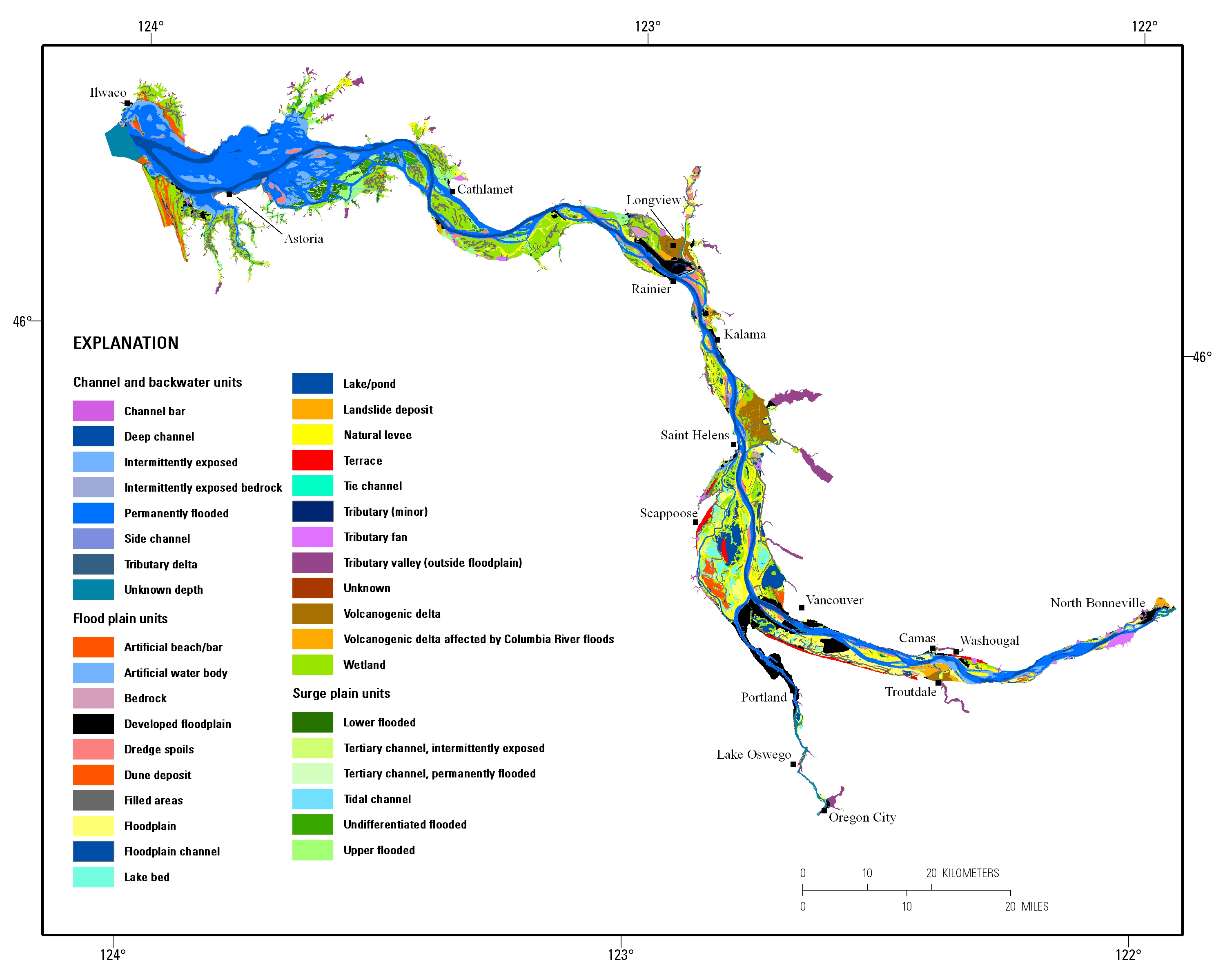
Estuarine ecosystems are controlled by a variety of processes that operate at multiple spatial and temporal scales. Understanding the hierarchical nature of these processes will aid in prioritization of restoration efforts. This hierarchical Columbia River Estuary Ecosystem Classification (henceforth "Classification") of the Columbia River estuary is a spatial database of the tidally-influenced reaches of the lower Columbia River, the tidally affected parts of its tributaries, and the landforms that make up their floodplains for the 230 kilometers between the Pacific Ocean and Bonneville Dam. This work is a collaborative effort between University of Washington School of Aquatic and Fishery Sciences (henceforth "UW"),...
This portion of the USGS data release presents bathymetry data collected during surveys performed in the Columbia River littoral cell and mouth of the Columbia River, Washington and Oregon, in 2022 (USGS Field Activity Number 2022-641-FA). Bathymetry data were collected using four personal watercraft (PWCs) equipped with single-beam sonar systems and global navigation satellite system (GNSS) receivers. The sonar systems consisted of either an Odom Echotrac CV-100 or CEE Hydrosystems Ceescope single-beam echosounder and 200 kHz transducer with a 9-degree beam angle. Raw acoustic backscatter returns were digitized by the echosounder with a vertical resolution of 1.25 cm. Depths from the echosounders were computed...
Categories: Data;
Types: Map Service,
OGC WFS Layer,
OGC WMS Layer,
OGC WMS Service;
Tags: Bathymetry and Elevation,
CMHRP,
Clatsop County,
Coastal and Marine Hazards and Resources Program,
Columbia River,
Sandy ocean beaches are a popular recreational destination, often surrounded by communities containing valuable real estate. Development is on the rise despite the fact that coastal infrastructure is subjected to flooding and erosion. As a result, there is an increased demand for accurate information regarding past and present shoreline changes. To meet these national needs, the Coastal and Marine Geology Program of the U.S. Geological Survey (USGS) is compiling existing reliable historical shoreline data along open-ocean sandy shores of the conterminous United States and parts of Alaska and Hawaii under the National Assessment of Shoreline Change project.There is no widely accepted standard for analyzing shoreline...
Categories: Data;
Types: ArcGIS REST Map Service,
ArcGIS Service Definition,
Downloadable,
Map Service;
Tags: Accretion,
CMGP,
Coastal and Marine Geology Program,
Columbia River,
DSAS,
Sandy ocean beaches are a popular recreational destination, often surrounded by communities containing valuable real estate. Development is on the rise despite the fact that coastal infrastructure is subjected to flooding and erosion. As a result, there is an increased demand for accurate information regarding past and present shoreline changes. To meet these national needs, the Coastal and Marine Geology Program of the U.S. Geological Survey (USGS) is compiling existing reliable historical shoreline data along open-ocean sandy shores of the conterminous United States and parts of Alaska and Hawaii under the National Assessment of Shoreline Change project.There is no widely accepted standard for analyzing shoreline...
Categories: Data;
Types: ArcGIS REST Map Service,
ArcGIS Service Definition,
Downloadable,
Map Service;
Tags: Accretion,
CMGP,
Cascade Longview,
Coastal and Marine Geology Program,
Columbia River,
The Large River Monitoring Forum compiled fish assemblage data for five large rivers in the U.S. as a part of a coordinated effort to compare and contract river monitoring efforts in large river systems. Fish community data from five monitoring programs were integrated to create the standardized dataset. Authors: Timothy D. Counihan1, Ian R. Waite2, Andy Casper3, David Ward4, Jennifer Sauer5, Elise Irwin6, Colin Chapman7, Brian Ickes5, Craig Paukert8, John Kosovich9, and Jennifer M. Bayer10 1- United States Geological Survey, Western Fisheries Research Center, Columbia River Research Laboratory, 5501A Cook-Underwood Road, Cook, WA 98605; email:tcounihan@usgs.gov; Phone:509-538-2299; Fax:509-538-2843 2- United States...
Categories: Data;
Types: Citation,
Map Service,
OGC WFS Layer,
OGC WMS Layer,
OGC WMS Service;
Tags: Colorado River,
Columbia River,
Fish,
Fish Assemblages,
Fish Community Analysis,
Sandy ocean beaches are a popular recreational destination, often surrounded by communities containing valuable real estate. Development is on the rise despite the fact that coastal infrastructure is subjected to flooding and erosion. As a result, there is an increased demand for accurate information regarding past and present shoreline changes. To meet these national needs, the Coastal and Marine Geology Program of the U.S. Geological Survey (USGS) is compiling existing reliable historical shoreline data along open-ocean sandy shores of the conterminous United States and parts of Alaska and Hawaii under the National Assessment of Shoreline Change project.There is no widely accepted standard for analyzing shoreline...
Categories: Data;
Types: ArcGIS REST Map Service,
ArcGIS Service Definition,
Downloadable,
Map Service;
Tags: Accretion,
CMGP,
Cascade Longview,
Coastal and Marine Geology Program,
Columbia River,
Boat-mounted acoustic doppler current profilers (ADCPs) were used to collect velocity data on the Columbia River in a small area near Northport, WA. Velocity surveys were collected during two surveys at high-flow, high-stage conditions in May 2018. Bathymetric data were also collected during one of the surveys using a single-beam echo-sounder. The datasets here provide 1) raw ADCP and single-beam survey data, 2) processed summaries of the data, primarily in geospatial data formats, and 3) summary visualizations of transect-averaged velocity and depth characteristics of the surveyed reach.
|

|
