Filters: Tags: Columbia River Basin (X)
33 results (88ms)|
Filters
Date Range
Extensions
Types Contacts
Categories Tag Types
|
For the past six years, the Bureau of Reclamation (BOR) has funded the USGS to study fish responses to restoration efforts and to construct a model relating stream habitat with fish population dynamics in the Methow River Basin, a tributary of the Columbia River. In the proposed study, we will use fish growth, distribution and movement (USGS data), foodweb data (Idaho State University), river flow (BOR data that we will expand) and water temperature data (from numerous agencies) to develop spatially-explicit bioenergetics models to assess effects of climate change on the viability of resident salmonid populations based on models being developed by USGS. The bioenergetics models will integrate such things as climate-change...
Categories: Data,
Project;
Types: Map Service,
OGC WFS Layer,
OGC WMS Layer,
OGC WMS Service;
Tags: Alberta,
British Columbia,
Bull Trout,
Climate Change,
Climate Change,

These data were released prior to the October 1, 2016 effective date for the USGS’s policy dictating the review, approval, and release of scientific data as referenced in USGS Survey Manual Chapter 502.8 Fundamental Science Practices: Review and Approval of Scientific Data for Release. The grtop_f grid represents the modeled elevation of the top of the Grande Ronde Basalt geomodel unit at a 500 foot resolution. It is one grid of a geomodel that consists of eleven grids and a spatial extent polygon shapefile. As part of a U.S. Geological Survey Groundwater Resources Program study, a three-dimensional geomodel was constructed for approximately 53,000 mi2 of the Columbia Plateau in Washington, Oregon, and Idaho. This...

These data were released prior to the October 1, 2016 effective date for the USGS’s policy dictating the review, approval, and release of scientific data as referenced in USGS Survey Manual Chapter 502.8 Fundamental Science Practices: Review and Approval of Scientific Data for Release. Septic systems are useful for removing and processing human waste. However, they have the potential of leaking or discharging waste into the nearby system and increasing potential contamination of nearby streams. Data represent potential locations of septic sewers in the Pacific Northwest based on extrapolation of 1990 Census tract block group level information.

Combined Thickness of the Modeled Wanapum Basalt and Vantage-Latah Interbed Geomodel Units (wnthk_f)
These data were released prior to the October 1, 2016 effective date for the USGS’s policy dictating the review, approval, and release of scientific data as referenced in USGS Survey Manual Chapter 502.8 Fundamental Science Practices: Review and Approval of Scientific Data for Release. The wnthk_f grid represents the modeled combined thickness of the Wanapum Basalt and the Vantage/Latah interbed geomodel units at a 500 foot resolution. It is one grid of a geomodel that consists of eleven grids and a spatial extent polygon shapefile. As part of a U.S. Geological Survey Groundwater Resources Program study, a three-dimensional geomodel was constructed for approximately 53,000 mi2 of the Columbia Plateau in Washington,...
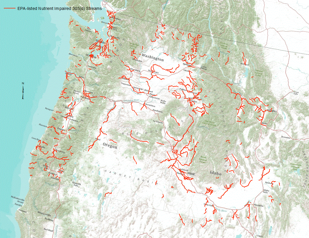
“Under section 303(d) of the 1972 Clean Water Act, states, territories, and authorized tribes are required to develop lists of impaired waters. These impaired waters do not meet water quality standards that states, territories, and authorized tribes have set for them, even after point sources of pollution have installed the minimum required levels of pollution control technology. The law requires that these jurisdictions establish priority rankings for waters on the lists and develop TMDLs for these waters” (U.S. Environmental Protection Agency, 2011). Waterways represented in this data set are a subset of these EPA 303 (d) listed streams that were classified as nutrient impaired. Nutrient impaired streams include...
Aquatic invasive species are often transported between water bodies on boats or boat trailers, thus they are considered one of the primary vectors for new introductions of invasive species to a water body. This data set contains geographic positioning system locational data for boater access points, use data (i.e. recreational, fishing), water quality measurements (e.g. calcium concentrations, pH), risk assessment data, and other physical attributes (i.e. size, elevation) where available within the Columbia and Snake Rivers and throughout the Columbia River Basin. This work builds on an earlier body of work by Wells et al. 2011, Prioritizing Zebra and Quagga Mussel Monitoring in the Columbia River Basin (PDF link...
Categories: Data;
Tags: Boat ramps,
Columbia River,
Columbia River Basin,
Dreissenids,
access points,
This dataset includes inputs and results for parameterizing the USGS Thornthwaite Monthly Water Balance Model (MWBM) to simulate annual stream permanence on National Hydrography Dataset (NHD) stream reaches. Also included are results from sensitivity analysis of MWBM parameters to final stream permanence classification (permanent or nonpermanent). The dataset includes files that link PRISM climate grids to NHD catchments and flowlines. Data tables describe the sensitivity of MWBM stream permanence classifications to each of the altered MWBM parameters. Suitable MWBM parameter sets, which resulted in accuracy of at least 65% when compared to observed surface water conditions, for modeling stream permanence are presented...
Categories: Data;
Types: Downloadable,
GeoTIFF,
Map Service,
OGC WFS Layer,
OGC WMS Layer,
OGC WMS Service,
Raster;
Tags: Columbia River Basin,
HUC17,
Hydrology,
Pacific Northwest,
USGS Science Data Catalog (SDC),

These data were released prior to the October 1, 2016 effective date for the USGS’s policy dictating the review, approval, and release of scientific data as referenced in USGS Survey Manual Chapter 502.8 Fundamental Science Practices: Review and Approval of Scientific Data for Release. The pmtop_f grid represents the modeled elevation of the top of the Older Bedrock geomodel unit at a 500 foot resolution. It is one grid of a geomodel that consists of eleven grids and a spatial extent polygon shapefile. As part of a U.S. Geological Survey Groundwater Resources Program study, a three-dimensional geomodel was constructed for approximately 53,000 mi2 of the Columbia Plateau in Washington, Oregon, and Idaho. This geomodel...

These data were released prior to the October 1, 2016 effective date for the USGS’s policy dictating the review, approval, and release of scientific data as referenced in USGS Survey Manual Chapter 502.8 Fundamental Science Practices: Review and Approval of Scientific Data for Release. Under section 303(d) of the 1972 Clean Water Act, states, territories, and authorized tribes are required to develop lists of impaired waters. These impaired waters do not meet water quality standards that states, territories, and authorized tribes have set for them, even after point sources of pollution have installed the minimum required levels of pollution control technology. The law requires that these jurisdictions establish...
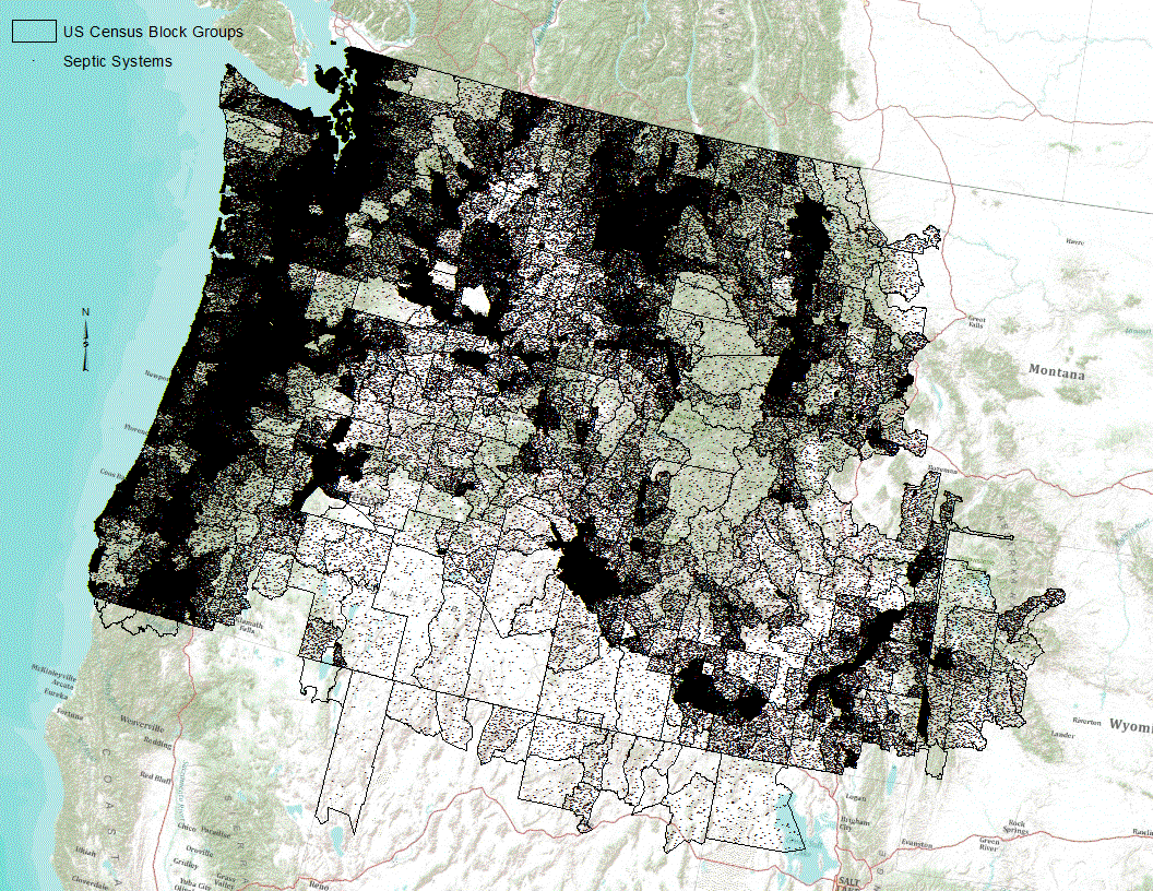
Septic systems are useful for removing and processing human waste. However, they have the potential of leaking or discharging waste into the nearby system and increasing potential contamination of nearby streams. Data represent potential locations of septic sewers in the Pacific Northwest based on extrapolation of 1990 Census tract block group level information.
Water temperature data were collected in summer 2018 and 2019. Temperature data loggers were deployed in tributary confluences and the mainstem of the lower Priest River between Priest Lake Outlet Dam and the confluence with the Pend Oreille River. Data loggers were checked every 2 to 3 weeks throughout the summer. Data for Lagrangian longitudinal thermal profiles were obtained on August 21, 2018 and August 7, 2019.
Categories: Data;
Tags: Aquatic Biology,
Climatology,
Columbia River basin,
Hydrology,
USGS Science Data Catalog (SDC),
Aquatic invasive species are often transported between water bodies on boats or boat trailers, thus they are considered one of the primary vectors for new introductions of invasive species to a water body. This data set contains geographic positioning system locational data for boater access points, use data (i.e. recreational, fishing), water quality measurements (e.g. calcium concentrations, pH), risk assessment data, and other physical attributes (i.e. size, elevation) where available within the Columbia and Snake Rivers and throughout the Columbia River Basin. This work builds on an earlier body of work by Wells et al. 2011, Prioritizing Zebra and Quagga Mussel Monitoring in the Columbia River Basin (PDF link...
Categories: Data;
Types: Downloadable,
Map Service,
OGC WFS Layer,
OGC WMS Layer,
Shapefile;
Tags: Boat ramps,
Columbia River,
Columbia River Basin,
Dreissenids,
access points,
This investigation sought to characterize the shedding of infectious hematopoietic necrosis virus (IHNV) in two populations of Columbia River Basin (CRB) Chinook salmon (Oncorhynchus tshawytscha). Juvenile spring- and fall-run Chinook salmon were exposed by immersion to each of three IHN virus strains from the UC, MD, and L subgroups, and then monitored for viral shedding from individual fish for 30 days. Detectable quantities of UC, MD and L IHN virus were shed by a subset of fish from each host population (1–9 out of 10 fish total in each treatment group). Viral shedding kinetics were consistent, with a rapid onset of shedding, peak shedding by 2–3 days, and then a rapid decline to below detectable levels by 7...
Categories: Data;
Tags: Chinook salmon,
Columbia River Basin,
IHNV,
Pacific Northwest,
USGS Science Data Catalog (SDC),

These data were released prior to the October 1, 2016 effective date for the USGS’s policy dictating the review, approval, and release of scientific data as referenced in USGS Survey Manual Chapter 502.8 Fundamental Science Practices: Review and Approval of Scientific Data for Release. The obtop_f grid represents the modeled elevation of the top of the Overburden geomodel unit at a 500 foot resolution. It is one grid of a geomodel that consists of eleven grids and a spatial extent polygon shapefile. As part of a U.S. Geological Survey Groundwater Resources Program study, a three-dimensional geomodel was constructed for approximately 53,000 mi2 of the Columbia Plateau in Washington, Oregon, and Idaho. This geomodel...

These data were released prior to the October 1, 2016 effective date for the USGS’s policy dictating the review, approval, and release of scientific data as referenced in USGS Survey Manual Chapter 502.8 Fundamental Science Practices: Review and Approval of Scientific Data for Release. Phosphorus is a naturally occurring element found in all rocks; the amount varies by the type of rock. The amount of phosphorus in sediments is expected to be correlated with the amount of phosphorus in the parent rocks. Streambed sediment collected by the National Uranium Resource Evaluation (NURE) Program were used to estimate the variation of phosphorus across the Pacific Northwest. This file provides an estimate of the mean concentration...
This project will evaluate the impacts of future climate change scenarios on the survival and viability of Pacific lamprey and Pacific Eulachon populations that are used as food sources by the Native American tribes of the Columbia River Basin and the coastal areas of Washington and Oregon. This evaluation will couple projected changes to ocean conditions and to freshwater habitat, and consider the effects of these changes on the life cycles of these fish populations.
Categories: Data,
Project;
Types: Map Service,
OGC WFS Layer,
OGC WMS Layer,
OGC WMS Service;
Tags: 2013,
Academics & scientific researchers,
Academics & scientific researchers,
Climate Change,
Columbia River Basin,
Categories: Project;
Tags: 2012,
Bureau of Reclamation,
Columbia River basin,
Klamath River basin,
NWCSC,
This data release combines seven airborne thermal infrared (TIR) remote sensing data sets of stream temperature collected along the mainstem of the Middle Fork John Day River (MFJD) in Oregon from 1994 to 2003. Years 1994, 1995, 1996, 1998, and 2002 have single datasets. Year 2003 has two data sets. Most of the TIR data covered the upstream half of the MFJD mainstem between river km 50 and 110, while the 2002 profile covers the lower half starting at the confluence of the MFJD with the North Fork John Day River through river kilometer 64. All TIR data sets were collected by helicopter in an upstream direction in August with the intent of capturing data at or near the maximum summer daily stream temperature. Ground-truthing...
Categories: Data;
Types: Downloadable,
Map Service,
OGC WFS Layer,
OGC WMS Layer,
Shapefile;
Tags: Climatology,
Columbia River basin,
Hydrology,
Middle Fork John Day River,
Remote Sensing,

These data were released prior to the October 1, 2016 effective date for the USGS’s policy dictating the review, approval, and release of scientific data as referenced in USGS Survey Manual Chapter 502.8 Fundamental Science Practices: Review and Approval of Scientific Data for Release. The obthk_f grid represents the modeled thickness of the Overburden geomodel unit at a 500 foot resolution. It is one grid of a geomodel that consists of eleven grids and a spatial extent polygon shapefile. As part of a U.S. Geological Survey Groundwater Resources Program study, a three-dimensional geomodel was constructed for approximately 53,000 mi2 of the Columbia Plateau in Washington, Oregon, and Idaho. This geomodel was constructed...
Categories: pre-SM502.8;
Tags: CPRAS,
Columbia Plateau,
Columbia Plateau Regional Aquifer System,
Columbia River Basin,
Idaho,
Montana Fish, Wildlife, and Parks (MT FWP), in collaboration with the United States Geological Survey (USGS) Wyoming-Montana Water Science Center (WY-MT WSC), Montana Department of Environmental Quality (MDEQ), and the United States Environmental Protection Agency (USEPA) collected fish from the Koocanusa Reservoir in 2021 for tissue analysis. Fish tissue collected included muscle, eggs, liver, and whole body. Analysis of tissues included characterization of the concentration of selenium, mercury and methyl mercury, nitrogen and carbon stable isotopes, and vitamins A and E. The purpose of these analyses was to inform state and federal management agencies on transboundary coal mining impacts to downstream fish health.
Categories: Data;
Types: Map Service,
OGC WFS Layer,
OGC WMS Layer,
OGC WMS Service;
Tags: Aquatic Biology,
Bioaccumulation,
Biota,
Columbia River Basin,
Environmental Health,
|

|
