Filters: Tags: Coral Reefs (X)
136 results (51ms)|
Filters
Date Range
Extensions
Types Contacts
Categories Tag Types
|

This dataset shows threats from coastal development estimated based on distance from cities, ports, airports, and dive tourism centers, as well as population density, population growth, and tourism growth in the area. For areas inside Marine Protected Areas (MPAs), management effectiveness was included as a mitigating threat.

Using mapped watersheds as a unit for summary statistics, we provide a series of indicators focused on land-based sources of threat within the US Virgin Islands. This includes indicators of a) the relative vulnerability of the land to erosion (based on slope, precipitation and soil erodibility); b) the relative erosion potential (REP) of the land, based on the relative vulnerability of the land, coupled with the current land cover type; c) the sediment delivery rate for each basin (percentage of eroded which reaches the river mouth); d) estimated sediment delivery for the basin, given current land use; e) the road density within the basin, and f) indictors of how erosion prone areas with roads might be (average...

This dataset depicts relative sediment delivery at the river mouth for each of over 3,000 watersheds draining into the Caribbean Sea and Gulf of Mexico.
Maps of relative classifications (low to high) for six resilience indicators and two anthropogenic stressors and a map of final relative resilience scores for 78 sites in the Commonwealth of the Northern Mariana Islands. The six resilience indicators are: bleaching resistance, coral diversity, coral recruitment, herbivore biomass, macroalgae cover and temperature variability. The two anthropogenic stressors are fishing access and nutrients and sediments. The resilience score map compares sites across all four of the surveyed islands: Saipan, Tinian, Aguijan, and Rota.
Categories: Data;
Tags: Commonwealth of the Northern Mariana Islands,
Coral Reefs,
Pacific Islands CASC,
Water, Coasts and Ice,
climate change,
The St. Petersburg Coastal and Marine Science Center is one of three science centers that conduct research within the USGS Coastal and Marine Hazards Research Program. The USGS St. Petersburg Coastal and Marine Science Center has a primary focus of investigating processes related to coastal and marine environments and their societal implications related to natural hazards, resource sustainability, and environmental change.
Despite being one of the most prevalent forms of consumerism in ecological communities, parasitism has largely been excluded from food-web models. Stable isotope analysis of consumers and their diets has been widely used in the study of food-webs for decades. However, the amount of information regarding parasite stable isotope ecology is limited, restricting the ability of ecologists to use stable isotope analysis to study parasites in food-webs. This study took advantage of distinct differences in the feeding ecology and trophic position of different species of fish known to host the same common micropredatory gnathiid isopod, to study the effects of host stable isotope ecology on that of the associated micropredator....
Categories: Data;
Tags: Eastern Caribbean,
Ecology,
Shallow/Mesophotic Coral Reef Biota,
St John, United States Virgin Islands,
Stable Isotopes,
Pacific Island societies value, depend on, and actively manage terrestrial and marine ecosystems for the multiple benefits they provide, including those associated with plant and animal abundance, resilience to natural disasters, and the flow of water, soil, and nutrients. New ecosystem service models developed for Pacific Island landscapes now integrate land-to-sea connections, allowing us to assess how land-based management actions and threats (e.g. changes to climate and land cover) affect ecosystem benefits, from ridge to reef. Affecting actual change on the ground, however, depends on how scientific information is accessed and used by managers and other decision makers who have the capacity to influence ecosystem...
Categories: Project;
Types: Map Service,
OGC WFS Layer,
OGC WMS Layer,
OGC WMS Service;
Tags: 2021,
CASC,
Coral Reefs,
Coral Reefs,
Drought, Fire and Extreme Weather,
This Project Snapshot provides an overview of the project "Valuing Climate Change Impacts on Coral Reef Ecosystem Services".
Episodic runoff carries suspended sediment to the nearshore environment, where it blocks light used for photosynthesis, smothers corals, inhibits coral recruitment, and triggers increases in macroalgae. Even small rainfalls create visible plumes over a few hours. Sediment affects coastal user enjoyment by deteriorating both ecosystem quality and visibility. Sources of erosion include unimproved roads, fallow and active agricultural fields, disturbed forests, local development, and streambanks. This is the primary output dataset from this project, which mapped bank erosion hotspots, constructed a reconnaissance sediment budget for the West Maui watersheds, and constructed a calibrated decision-support model capable...
Categories: Data;
Types: Map Service,
OGC WFS Layer,
OGC WMS Layer,
OGC WMS Service;
Tags: Coral Reefs,
Pacific Islands CASC,
Rivers, Streams and Lakes,
Water, Coasts and Ice
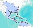
This dataset depicts watershed boundaries with a minimum size of 35 square kilometers for the Caribbean region.

Using watersheds derived from a hydrologically-corrected 30m resolution DEM as a unit for summary statistics, we provide a series of indicators focused on land-based sources of threat within the US Virgin Islands and Puerto Rico. This includes indicators of a) the relative vulnerability of the land to erosion (based on slope, precipitation and soil erodibility); b) the relative erosion potential (REP) of the land, based on the relative vulnerability of the land, coupled with the current land cover type; c) the sediment delivery rate for each basin (percentage of eroded which reaches the river mouth); d) estimated sediment delivery for the basin, given current land use;

Grid reflects locations of estimated aragonite saturation state under a CO2 stabilization level of 380 ppm, which is approximately equivalent to the present day (2011). The indicator of ocean acidification is the projected saturation level of aragonite, the form of calcium carbonate that corals use to build their skeletons. As dissolved CO2 levels increase, the aragonite saturation state decreases, which makes it more difficult for coral to build their skeletons. Aragonite saturation states of less than 3.0 are extremely marginal for coral growth. See the Reefs at Risk Revisited report and technical notes for more information.

Agriculture, though important to economic development and food security, is a source of increased sediment, nutrient, and pesticide runoff. Threats from sedimentation and pollution from inland sources were modeled for over 3,000 watersheds discharging into the Caribbean.
Coral reefs are sometimes called “rainforests of the sea” because of their immense biological diversity and economic value. While coral reefs are sensitive to changes in their environment such as altered temperature or pollution, some reefs are more resilient, or able to recover from disturbance more quickly, than others. The overarching objective of this project was to gather information on coral reef resilience and vulnerability to climate change that could inform coastal management decision-making in the Commonwealth of the Northern Mariana Islands (CNMI). Scientists collaborated with local managers to survey reefs at 78 locations throughout the CMNI and evaluate indicators of resilience, such as numbers of juvenile...
Categories: Project;
Types: Map Service,
OGC WFS Layer,
OGC WMS Layer,
OGC WMS Service;
Tags: 2013,
CASC,
Completed,
Coral Reefs,
Coral Reefs,
Coral reefs provide numerous ecosystem goods and services critical to human well-being (e.g., protection from storms and floods, food, income, recreation, and cultural practices), but those ecosystems are under serious threat due to growing human pressures, including overfishing, land-based pollution, and global climate change. Managers facing complex problems require decision-support tools that can guide costeffective action across the entire watershed, from ridge to reef. This project built a pilot tool for coral reef management that can map, assess, and value key goods and services from the reef environment. It provides important information to managers on the areas supplying the most value to humans, as well...
Categories: Publication;
Types: Citation;
Tags: Coral Reefs,
Coral Reefs,
Data Visualization & Tools,
Pacific Islands CASC,
Science Tools For Managers,
Satellite-tracked, DGPS-equipped Lagrangian surface-current drifter deployments were conducted over 12 weeks between 14 April and 7 July 2015 at various locations within and offshore of the National Park of American Samoa study area to track surface currents. The drifters internally logged their location every 1 minute, and they transmitted their positions to satellites every 5 minutes. A drogue was attached to the drifters at 1 m below sea level in order to track the currents at that depth.
Categories: Data;
Types: Citation;
Tags: CORAL REEFS,
National Park of American Samoa,
OCEAN CURRENTS,
Ocean Circulation,
Oceans,
We developed the HyCReWW metamodel to predict wave run-up under a wide range of coral reef morphometric and offshore forcing characteristics. Due to the complexity and high dimensionality of the problem, we assumed an idealized one-dimensional reef profile, characterized by seven primary parameters. XBeach Non-Hydrostatic was chosen to create the synthetic dataset and Radial Basis Functions implemented in Matlab were chosen for interpolation. Results demonstrate the applicability of the metamodel to obtain fast and accurate results of wave run-up for a large range of intrinsic coral reef morphologic and extrinsic hydrodynamic forcing parameters, offering a useful tool for risk management and early warning systems....

Reef polygons classified by estimated threat from marine-based pollution and damage. The indicator of threat from marine-based pollution and damage was based on the size and volume of commercial shipping ports, size and volume of cruise ship ports, intensity of shipping traffic, and the location of oil infrastructure. Values of 0 indicate low threat, 100 indicate medium threat, 1000 indicate high threat.

This dataset depicts threats from marine-based sources evaluated based on distance to ports, stratified by size; intensity of cruise ship visitation; and distance to oil and gas infrastructure, processing, and pipelines.

Agriculture, though important to economic development and food security, is a source of increased sediment, nutrient, and pesticide runoff. Threats to coral reefs from sedimentation and pollution from inland sources were modeled for over 3,000 watersheds discharging into the Caribbean.
|

|
