Filters: Tags: Crane Lake (X)
12 results (102ms)|
Filters
Date Range
Types Contacts
Categories Tag Types Tag Schemes |
The U.S. Geological Survey, Voyageurs National Park, South Dakota State University, and Missouri Department of Conservation conducted a cooperative study to measure ratios of strontium to calcium (Sr:Ca) in cross sections of pectoral fin rays obtained from lake sturgeon (Acipenser fulvescens) captured in lakes and rivers of Namakan Reservoir in Minnesota and Ontario. We measured Sr:Ca ratios in cross sections of 37 pectoral fin rays collected from 10 locations (5 rivers and 5 lakes) in Namakan Reservoir as part of a larger study to investigate whether relations between Sr:Ca in water and pectoral fin rays were significant and useful for determining migratory histories of lake sturgeon in Namakan Reservoir. Pectoral...
Categories: Data;
Types: Map Service,
OGC WFS Layer,
OGC WMS Layer,
OGC WMS Service;
Tags: Aquatic Biology,
Crane Lake,
Echo River,
Ecology,
Hydrology,
These data tables summarize land cover classifications, slope measurements, and inundated area estimates for several lakes in northern Minnesota, as part of a larger project seeking to identify associations between young-of-year Yellow Perch mercury content and water level metrics, temperature, and annual deposition data in a multivariate analysis. One table presents inundated area estimates for a range of water surface elevations in 0.1 meter increments between a range of seasonal minimum and maximum water surface elevation values. The other table summarizes the percent cover and number of hectares of each land cover class within a specified buffered area around each study sampling site, along with a measure of...
Categories: Data;
Tags: Crane Lake,
Kabetogama Lake,
Little Vermilion Lake,
Minnesota,
Namakan Lake,
Water level fluctuations substantially alter the fauna, flora and microbial community of near-shore aquatic ecosystems. Water level management therefore has the potential to strongly influence a wide variety of ecosystem processes. Many northern temperate lake food webs experience substantial methylmercury contamination, which is partially mediated by the action of sulfate reducing bacteria occurring in sediments that are periodically inundated. For lakes with methylmercury problems, water level management could be designed to reduce methylmercury contamination. These data summarize inundated areas at varying water surface elevations for several northern Minnesota lakes, as part of the project described above. The...
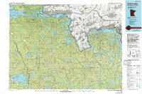
USGS Historical Quadrangle in GeoPDF.
This data set contains imagery from the National Agriculture Imagery Program (NAIP). The NAIP program is administered by USDA FSA and has been established to support two main FSA strategic goals centered on agricultural production. These are, increase stewardship of America's natural resources while enhancing the environment, and to ensure commodities are procured and distributed effectively and efficiently to increase food security. The NAIP program supports these goals by acquiring and providing ortho imagery that has been collected during the agricultural growing season in the U.S. The NAIP ortho imagery is tailored to meet FSA requirements and is a fundamental tool used to support FSA farm and conservation programs....
The U.S. Department of Agriculture - Forest Service (USDA-FS) has been evaluating hazards and classifications at the dams of four small reservoirs in the Mark Twain National Forest in Missouri. These reservoirs are Crane Lake near Annapolis, Fourche Lake near Briar, McCormack Lake near Greer, and Sterling Hollow Lake near Willow Springs. Conventional topographic surveys were used to provide data needed for as-built information of the earthen dam structure, spillways, and groins at each of the dams. High-resolution terrestrial light detection and ranging (T-LiDAR) data also were collected for the concrete spillway structure at Crane Lake Dam to provide baseline data for potential monitoring and change detection....
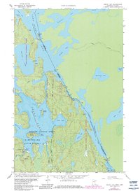
USGS Historical Quadrangle in GeoPDF.
This data set contains imagery from the National Agriculture Imagery Program (NAIP). The NAIP program is administered by USDA FSA and has been established to support two main FSA strategic goals centered on agricultural production. These are, increase stewardship of America's natural resources while enhancing the environment, and to ensure commodities are procured and distributed effectively and efficiently to increase food security. The NAIP program supports these goals by acquiring and providing ortho imagery that has been collected during the agricultural growing season in the U.S. The NAIP ortho imagery is tailored to meet FSA requirements and is a fundamental tool used to support FSA farm and conservation programs....
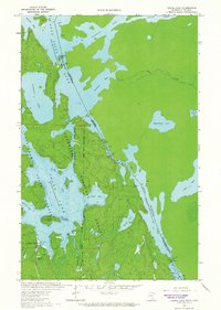
USGS Historical Quadrangle in GeoPDF.
Water level fluctuations substantially alter the fauna, flora and microbial community of near-shore aquatic ecosystems. Water level management therefore has the potential to strongly influence a wide variety of ecosystem processes. Many northern temperate lake food webs experience substantial methylmercury contamination, which is partially mediated by the action of sulfate reducing bacteria occurring in sediments that are periodically inundated. For lakes with methylmercury problems, water level management could be designed to reduce methylmercury contamination. These data summarize land cover and slope characteristics within specified, buffered areas around study sites that were sampled in several northern Minnesota...
Categories: Data;
Tags: Crane Lake,
Kabetogama Lake,
Little Vermilion Lake,
Minnesota,
Namakan Lake,
This data set contains imagery from the National Agriculture Imagery Program (NAIP). The NAIP program is administered by USDA FSA and has been established to support two main FSA strategic goals centered on agricultural production. These are, increase stewardship of America's natural resources while enhancing the environment, and to ensure commodities are procured and distributed effectively and efficiently to increase food security. The NAIP program supports these goals by acquiring and providing ortho imagery that has been collected during the agricultural growing season in the U.S. The NAIP ortho imagery is tailored to meet FSA requirements and is a fundamental tool used to support FSA farm and conservation programs....
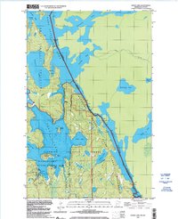
USGS Historical Quadrangle in GeoPDF.
|

|
