Filters: Tags: Crane Prairie Reservoir (X)
9 results (123ms)|
Filters
Date Range
Types Contacts
Categories Tag Types Tag Schemes |
This data set contains imagery from the National Agriculture Imagery Program (NAIP). The NAIP program is administered by USDA FSA and has been established to support two main FSA strategic goals centered on agricultural production. These are, increase stewardship of America's natural resources while enhancing the environment, and to ensure commodities are procured and distributed effectively and efficiently to increase food security. The NAIP program supports these goals by acquiring and providing ortho imagery that has been collected during the agricultural growing season in the U.S. The NAIP ortho imagery is tailored to meet FSA requirements and is a fundamental tool used to support FSA farm and conservation programs....
Types: Citation;
Tags: 3.75 x 3.75 minute,
41017,
4312110,
Aerial Compliance,
CRANE PRAIRIE RESERVOIR,
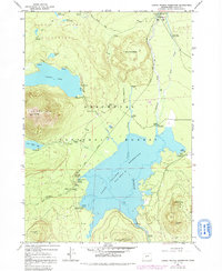
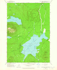
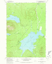
USGS Historical Quadrangle in GeoPDF.
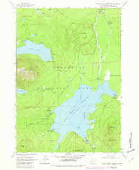
USGS Historical Quadrangle in GeoPDF.
This data set contains imagery from the National Agriculture Imagery Program (NAIP). The NAIP program is administered by USDA FSA and has been established to support two main FSA strategic goals centered on agricultural production. These are, increase stewardship of America's natural resources while enhancing the environment, and to ensure commodities are procured and distributed effectively and efficiently to increase food security. The NAIP program supports these goals by acquiring and providing ortho imagery that has been collected during the agricultural growing season in the U.S. The NAIP ortho imagery is tailored to meet FSA requirements and is a fundamental tool used to support FSA farm and conservation programs....
Types: Citation;
Tags: 3.75 x 3.75 minute,
41017,
4312110,
Aerial Compliance,
CRANE PRAIRIE RESERVOIR,
USGS Historical Quadrangle in GeoPDF.
USGS Historical Quadrangle in GeoPDF.
This dataset is a collection of hyperspectral imagery profiles of algae, many associated with Harmful Algae Blooms (HABs). Data were collected using a microscope-based hyperspectral imaging system with the cooperation of the National Institute of Standards and Technology. Samples were collected from U.S. Geological Survey (USGS) water quality sampling efforts, to include water quality parameters and algal biomass. Data are shown in basic hyperspectral imagery form, normalized to 1.
Categories: Data;
Tags: Blue Mesa Reservoir, CO,
Blue River,
Clackamas,
Cougar Reservoir,
Crane Prairie Reservoir,
|

|
