Filters: Tags: Defoliation (X)
43 results (23ms)|
Filters
|

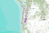
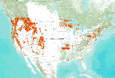
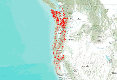
This dataset is a compilation of forest insect, disease and abiotic damage mapped by aerial detection surveys on forested areas in the United States. At this time, the National Aerial Survey Data Standards require only mortality and defoliation data be collected and reported. However, many cooperators collect data on other types of damage and therefore, the national database has been designed to accommodate these data. Low-level flights, typically 1,000 to 2,000 feet above ground level, are used to map forest damage. Observers use paper maps, typically 1:100,000 scale USGS maps, upon which they record the damage. There is also a digital sketchmap system that may be used. The digital system uses GPS to display the...

This dataset is a compilation of forest insect, disease and abiotic damage mapped by aerial detection surveys on forested areas in the United States. At this time, the National Aerial Survey Data Standards require only mortality and defoliation data be collected and reported. However, many cooperators collect data on other types of damage and therefore, the national database has been designed to accommodate these data. Low-level flights, typically 1,000 to 2,000 feet above ground level, are used to map forest damage. Observers use paper maps, typically 1:100,000 scale USGS maps, upon which they record the damage. There is also a digital sketchmap system that may be used. The digital system uses GPS to display the...
This dataset is a compilation of forest insect, disease and abiotic damage mapped by aerial detection surveys on forested areas in the United States. At this time, the National Aerial Survey Data Standards require only mortality and defoliation data be collected and reported. However, many cooperators collect data on other types of damage and therefore, the national database has been designed to accommodate these data. Low-level flights, typically 1,000 to 2,000 feet above ground level, are used to map forest damage. Observers use paper maps, typically 1:100,000 scale USGS maps, upon which they record the damage. There is also a digital sketchmap system that may be used. The digital system uses GPS to display the...
This dataset is a compilation of forest insect, disease and abiotic damage mapped by aerial detection surveys on forested areas in the United States. At this time, the National Aerial Survey Data Standards require only mortality and defoliation data be collected and reported. However, many cooperators collect data on other types of damage and therefore, the national database has been designed to accommodate these data. Low-level flights, typically 1,000 to 2,000 feet above ground level, are used to map forest damage. Observers use paper maps, typically 1:100,000 scale USGS maps, upon which they record the damage. There is also a digital sketchmap system that may be used. The digital system uses GPS to display the...

This dataset is a compilation of forest insect, disease and abiotic damage mapped by aerial detection surveys on forested areas in the United States. At this time, the National Aerial Survey Data Standards require only mortality and defoliation data be collected and reported. However, many cooperators collect data on other types of damage and therefore, the national database has been designed to accommodate these data. Low-level flights, typically 1,000 to 2,000 feet above ground level, are used to map forest damage. Observers use paper maps, typically 1:100,000 scale USGS maps, upon which they record the damage. There is also a digital sketchmap system that may be used. The digital system uses GPS to display the...
This dataset is a compilation of forest insect, disease and abiotic damage mapped by aerial detection surveys on forested areas in the United States. At this time, the National Aerial Survey Data Standards require only mortality and defoliation data be collected and reported. However, many cooperators collect data on other types of damage and therefore, the national database has been designed to accommodate these data. Low-level flights, typically 1,000 to 2,000 feet above ground level, are used to map forest damage. Observers use paper maps, typically 1:100,000 scale USGS maps, upon which they record the damage. There is also a digital sketchmap system that may be used. The digital system uses GPS to display the...
This is part of a 3-tiered dataset consisting ofIDS_shapes: footprint polygon featuresIDS_attrib: attribute descriptions of polygonsIDS_rollup: lookup information for features that are summarized as a group (rollup)This dataset is a compilation of forest insect, disease and abiotic damage mapped by aerial detection surveys on forested areas in the United States. At this time, the National Aerial Survey Data Standards require only mortality and defoliation data be collected and reported. However, many cooperators collect data on other types of damage and therefore, the national database has been designed to accommodate these data. Low-level flights, typically 1,000 to 2,000 feet above ground level, are used to map...

This dataset is a compilation of forest insect, disease and abiotic damage mapped by aerial detection surveys on forested areas in the United States. At this time, the National Aerial Survey Data Standards require only mortality and defoliation data be collected and reported. However, many cooperators collect data on other types of damage and therefore, the national database has been designed to accommodate these data. Low-level flights, typically 1,000 to 2,000 feet above ground level, are used to map forest damage. Observers use paper maps, typically 1:100,000 scale USGS maps, upon which they record the damage. There is also a digital sketchmap system that may be used. The digital system uses GPS to display the...

This dataset is a compilation of forest insect, disease and abiotic damage mapped by aerial detection surveys on forested areas in the United States. At this time, the National Aerial Survey Data Standards require only mortality and defoliation data be collected and reported. However, many cooperators collect data on other types of damage and therefore, the national database has been designed to accommodate these data. Low-level flights, typically 1,000 to 2,000 feet above ground level, are used to map forest damage. Observers use paper maps, typically 1:100,000 scale USGS maps, upon which they record the damage. There is also a digital sketchmap system that may be used. The digital system uses GPS to display the...
This data release includes metadata and tabular data that document estimates of litterfall, koa moth (Scotorythra paludicola) caterpillar frass production, soil nutrients, and foliar nutrients during 2013-2014 at Hakalau Forest National Wildlife Refuge. During this time, there was a massive defoliation event of Acacia koa (koa) trees by the koa moth. We monitored these metrics in 4 sites that varied in forest structure and composition at Hakalau. We used litter traps to monitor koa litter fall over time and foliar %N to estimate N inputs from litter. We used caterpillar counts, koa canopy estimates, frass production rates, and frass %N to estimate N inputs from frass on the landscape. We used resin bags under koa...
This data release includes metadata and tabular data that document estimates of litterfall, koa moth (Scotorythra paludicola) caterpillar frass production, soil nutrients, and foliar nutrients during 2013-2014 at Hakalau Forest National Wildlife Refuge. During this time, there was a massive defoliation event of Acacia koa (koa) trees by the koa moth. We monitored these metrics in 4 sites that varied in forest structure and composition at Hakalau. We used litter traps to monitor koa litter fall over time and foliar %N to estimate N inputs from litter. We used caterpillar counts, koa canopy estimates, frass production rates, and frass %N to estimate N inputs from frass on the landscape. We used resin bags under koa...
Categories: Data;
Tags: Hakalau Forest National Wildlife Refuge,
Hawaii Island,
biota,
defoliation,
foliar nutrients,
Observers assessed the density and monitored the defoliation, refoliation, and survival of koa (Acacia koa) trees during the 2013-2014 outbreak of the koa moth (Scotorythra paludicola) at Hakalau Forest National Wildlife Refuge. Koa trees were tagged, classified by size class, and assessed on 55 plots (10-m radius) randomly located in two forest types (reforestation and natural forest) near Pedro and Pua Akala roads. Density and size class distribution was also assessed for ohia (Metrosideros polymorpha) trees on each plot. This dataset provides the location data for all plots.
Categories: Data;
Tags: Hakalau Forest National Wildlife Refuge,
Hawaii Island,
biota,
defoliation,
foliage regrowth,

This dataset is a compilation of forest insect, disease and abiotic damage mapped by aerial detection surveys on forested areas in the United States. At this time, the National Aerial Survey Data Standards require only mortality and defoliation data be collected and reported. However, many cooperators collect data on other types of damage and therefore, the national database has been designed to accommodate these data. Low-level flights, typically 1,000 to 2,000 feet above ground level, are used to map forest damage. Observers use paper maps, typically 1:100,000 scale USGS maps, upon which they record the damage. There is also a digital sketchmap system that may be used. The digital system uses GPS to display the...

This dataset is a compilation of forest insect, disease and abiotic damage mapped by aerial detection surveys on forested areas in the United States. At this time, the National Aerial Survey Data Standards require only mortality and defoliation data be collected and reported. However, many cooperators collect data on other types of damage and therefore, the national database has been designed to accommodate these data. Low-level flights, typically 1,000 to 2,000 feet above ground level, are used to map forest damage. Observers use paper maps, typically 1:100,000 scale USGS maps, upon which they record the damage. There is also a digital sketchmap system that may be used. The digital system uses GPS to display the...
This data release includes metadata and tabular data that document the response of koa (Acacia koa) trees to defoliation by the koa moth (Scotorythra paludicola) during 2013-2014 at Hakalau Forest National Wildlife Refuge. Data were collected on 55 plots at 4 sites representing 2 habitat types with either high or low koa densities. Ohia (Metrosideros polymorpha) trees dominated habitats with low koa density. Data sets document (1) locations and habitat type of forest plots where koa trees were evaluated, (2) density and size of koa trees within plots, extent of koa tree defoliation, rate of koa tree foliage regrowth (refoliation), and koa tree mortality, and (3) counts and relative size of ohia trees for evaluating...
This data release includes metadata and tabular data that document estimates of litterfall, koa moth (Scotorythra paludicola) caterpillar frass production, soil nutrients, and foliar nutrients during 2013-2014 at Hakalau Forest National Wildlife Refuge. During this time, there was a massive defoliation event of Acacia koa (koa) trees by the koa moth. We monitored these metrics in 4 sites that varied in forest structure and composition at Hakalau. We used resin bags under koa canopy where frass was directly falling as compared to open grass sites where no frass was falling to monitor soil inorganic nitrogen and phosphorus over time. By comparing soil with frass inputs to frass inputs over time we could watch for...
Categories: Data;
Tags: Hakalau Forest National Wildlife Refuge,
Hawaii Island,
biota,
defoliation,
foliar nutrients,

This dataset is a compilation of forest insect, disease and abiotic damage mapped by aerial detection surveys on forested areas in the United States. At this time, the National Aerial Survey Data Standards require only mortality and defoliation data be collected and reported. However, many cooperators collect data on other types of damage and therefore, the national database has been designed to accommodate these data. Low-level flights, typically 1,000 to 2,000 feet above ground level, are used to map forest damage. Observers use paper maps, typically 1:100,000 scale USGS maps, upon which they record the damage. There is also a digital sketchmap system that may be used. The digital system uses GPS to display the...
Observers assessed the density and monitored the defoliation, refoliation, and survival of koa (Acacia koa) trees during the 2013-2014 outbreak of the koa moth (Scotorythra paludicola) at Hakalau Forest National Wildlife Refuge. Koa trees were tagged, classified by size class, and assessed on 55 plots (10-m radius) randomly located in two forest types (reforestation and natural forest) near Pedro and Pua Akala roads.This dataset contains data on the individual koa tree identify, plot location, forest type, size, and defoliation and refoliation dynamics.
Categories: Data;
Tags: Hakalau Forest National Wildlife Refuge,
Hawaii Island,
biota,
defoliation,
foliage regrowth,

This dataset is a compilation of forest insect, disease and abiotic damage mapped by aerial detection surveys on forested areas in the United States. At this time, the National Aerial Survey Data Standards require only mortality and defoliation data be collected and reported. However, many cooperators collect data on other types of damage and therefore, the national database has been designed to accommodate these data. Low-level flights, typically 1,000 to 2,000 feet above ground level, are used to map forest damage. Observers use paper maps, typically 1:100,000 scale USGS maps, upon which they record the damage. There is also a digital sketchmap system that may be used. The digital system uses GPS to display the...
This is part of a 3-tiered dataset consisting ofIDS_shapes: footprint polygon featuresIDS_attrib: attribute descriptions of polygonsIDS_rollup: lookup information for features that are summarized as a group (rollup)This dataset is a compilation of forest insect, disease and abiotic damage mapped by aerial detection surveys on forested areas in the United States. At this time, the National Aerial Survey Data Standards require only mortality and defoliation data be collected and reported. However, many cooperators collect data on other types of damage and therefore, the national database has been designed to accommodate these data. Low-level flights, typically 1,000 to 2,000 feet above ground level, are used to map...
|

|
