Filters: Tags: Drainage (X)
102 results (124ms)|
Filters
Date Range
Extensions Types Contacts
Categories Tag Types
|

Major river and water body outlines derived from Metro's Riv_poly data layer. Includes: the Columbia, Willamette, Sandy, Clackamas and Lewis Rivers; Lake Oswego; Smith, Bybee, Vancouver and Sturgeon Lakes. Downloaded from Metro's RLIS Discovery site 7/2/2012.

The USGS National Hydrography Dataset (NHD) service from The National Map (TNM) is a comprehensive set of digital spatial data that encodes information about naturally occurring and constructed bodies of surface water (lakes, ponds, and reservoirs), paths through which water flows (canals, ditches, streams, and rivers), and related entities such as point features (springs, wells, stream gages, and dams). The information encoded about these features includes classification and other characteristics, delineation, geographic name, position and related measures, a "reach code" through which other information can be related to the NHD, and the direction of water flow. The network of reach codes delineating water and...
Categories: Data;
Types: ArcGIS REST Map Service,
Map Service;
Tags: HU,
Hydrography,
NGP-TNM,
NHD,
Overlay Map Service,

HydroSHEDS (Hydrological data and maps based on SHuttle Elevation Derivatives at multiple Scales) provides hydrographic information in a consistent and comprehensive format for regional and global-scale applications. HydroSHEDS offers a suite of geo-referenced data sets (vector and raster), including stream networks, watershed boundaries, drainage directions, and ancillary data layers such as flow accumulations, distances, and river topology information. HydroSHEDS is derived from elevation data of the Shuttle Radar Topography Mission (SRTM) at 3 arc-second resolution. Available HydroSHEDS resolutions range from 3 arc-second (approx. 90 meters at the equator) to 5 minute (approx. 10 km at the equator) with seamless...

HydroSHEDS (Hydrological data and maps based on SHuttle Elevation Derivatives at multiple Scales) provides hydrographic information in a consistent and comprehensive format for regional and global-scale applications. HydroSHEDS offers a suite of geo-referenced data sets (vector and raster), including stream networks, watershed boundaries, drainage directions, and ancillary data layers such as flow accumulations, distances, and river topology information. HydroSHEDS is derived from elevation data of the Shuttle Radar Topography Mission (SRTM) at 3 arc-second resolution. Available HydroSHEDS resolutions range from 3 arc-second (approx. 90 meters at the equator) to 5 minute (approx. 10 km at the equator) with seamless...

HydroSHEDS (Hydrological data and maps based on SHuttle Elevation Derivatives at multiple Scales) provides hydrographic information in a consistent and comprehensive format for regional and global-scale applications. HydroSHEDS offers a suite of geo-referenced data sets (vector and raster), including stream networks, watershed boundaries, drainage directions, and ancillary data layers such as flow accumulations, distances, and river topology information. HydroSHEDS is derived from elevation data of the Shuttle Radar Topography Mission (SRTM) at 3 arc-second resolution. Available HydroSHEDS resolutions range from 3 arc-second (approx. 90 meters at the equator) to 5 minute (approx. 10 km at the equator) with seamless...

HydroSHEDS (Hydrological data and maps based on SHuttle Elevation Derivatives at multiple Scales) provides hydrographic information in a consistent and comprehensive format for regional and global-scale applications. HydroSHEDS offers a suite of geo-referenced data sets (vector and raster), including stream networks, watershed boundaries, drainage directions, and ancillary data layers such as flow accumulations, distances, and river topology information. HydroSHEDS is derived from elevation data of the Shuttle Radar Topography Mission (SRTM) at 3 arc-second resolution. Available HydroSHEDS resolutions range from 3 arc-second (approx. 90 meters at the equator) to 5 minute (approx. 10 km at the equator) with seamless...
These data were released prior to the October 1, 2016 effective date for the USGS’s policy dictating the review, approval, and release of scientific data as referenced in USGS Survey Manual Chapter 502.8 Fundamental Science Practices: Review and Approval of Scientific Data for Release. This vector coverage of hydrography centerlines was derived from the National Hydrography Dataset (NHD), and encompasses all of Ohio and portions of Indiana, Michigan, Kentucky, West Virginia, Pennsylvania, and New York. This coverage is comprised of 105 Catalog Units (CUs) obtained from http://nhd.usgs.gov/. Each CU approximately represents a single 8-digit Hydrologic Unit Code (HUC).
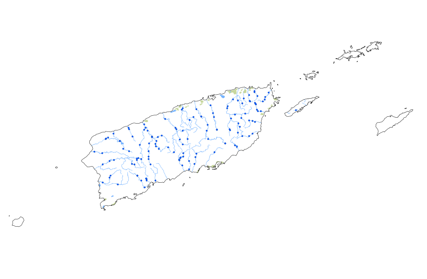
This geodatabase contains streams, waterbodies and wetlands, streamflow gaging stations, and coastlines for Puerto Rico and the U.S. Virgin Islands. The streams are incorporated into a geometric network. All feature classes are vertically integrated with each other and with 1:1,000,000-scale transportation and boundary data sets.

Major rivers and water bodies derived from Metro's Riv_poly data layer. Includes: the Columbia, Willamette, Sandy, Clackamas and Lewis Rivers; Lake Oswego; Smith, Bybee, Vancouver and Sturgeon Lakes. Downloaded from Metro's RLIS Discovery site 7/2/2012.

This dataset represents the soil hydrologic group from SSURGO and STATSGO soil descriptions for soil map units in the state of western Washington that lie within the North Pacific Landscape Conservation Cooperative. Definition The complete definition and official criteria for hydrologic soil groups are available online at (Title 210, National Engineering Handbook, Part 630, Chapter 7, “Hydrologic Soil Groups”). “Hydrologic group” is a group of soils having similar runoff potential under similar storm and cover conditions. Soil properties that influence runoff potential are those that influence the minimum rate of infiltration for a bare soil after prolonged wetting and when not frozen. These properties are...

HydroSHEDS (Hydrological data and maps based on SHuttle Elevation Derivatives at multiple Scales) provides hydrographic information in a consistent and comprehensive format for regional and global-scale applications. HydroSHEDS offers a suite of geo-referenced data sets (vector and raster), including stream networks, watershed boundaries, drainage directions, and ancillary data layers such as flow accumulations, distances, and river topology information. HydroSHEDS is derived from elevation data of the Shuttle Radar Topography Mission (SRTM) at 3 arc-second resolution. Available HydroSHEDS resolutions range from 3 arc-second (approx. 90 meters at the equator) to 5 minute (approx. 10 km at the equator) with seamless...

HydroSHEDS (Hydrological data and maps based on SHuttle Elevation Derivatives at multiple Scales) provides hydrographic information in a consistent and comprehensive format for regional and global-scale applications. HydroSHEDS offers a suite of geo-referenced data sets (vector and raster), including stream networks, watershed boundaries, drainage directions, and ancillary data layers such as flow accumulations, distances, and river topology information. HydroSHEDS is derived from elevation data of the Shuttle Radar Topography Mission (SRTM) at 3 arc-second resolution. Available HydroSHEDS resolutions range from 3 arc-second (approx. 90 meters at the equator) to 5 minute (approx. 10 km at the equator) with seamless...
This data release consists of a comma-delimited ascii file with attributes for 21 U.S. Geological Survey streamgage sites in Hawai‘i and Southeast Alaska selected to enable assessment of how floods might change in a future climate. Floods in Hawai‘i and Southeast Alaska have led to loss of human life; damage to agricultural crops, cultural and biological resources, infrastructure, and property; threats to public health; and conditions that are highly disruptive to residents and visitors. Floods are generated by atmospheric and terrestrial processes that may be enhanced or depressed in response to climate change. Understanding the mechanisms that generate floods can be useful for assessing how floods may change in...
TEON uses a “nested” approach to data collection. The smallest unit within TEON is a Station. Stationsinclude discrete sampling locations or units (e.g., plot or transect) where repeated measures of a givenvariable are collected to create a time-series. Data collected at a station may be relevant to localconditions (e.g., soil temperature at a given site) or applicable to a larger area (e.g., streamgage locatedat the lower end of a watershed). A Site is a collection of stations that are typically located within closeproximity to each other. Sites are grouped into Watersheds. Watersheds will encompass many ecotypes and span multiple ecoregions. Watersheds in aggregate form the TEON network.
Categories: Data;
Types: Map Service,
OGC WFS Layer,
OGC WMS Layer,
OGC WMS Service;
Tags: AIR TEMPERATURE,
AIR TEMPERATURE,
ATMOSPHERE,
ATMOSPHERE,
Academics & scientific researchers,
Map of the Kuparuk River Area and location of proposed observation sites (numbered circles). The Watershed spans from the upper Brooks Foothills to the Coastal Plain Ecoregions. Inset shows the location of the seven TEON focal watersheds. Image by Arctic LCC staff.
Categories: Data;
Types: Map Service,
OGC WFS Layer,
OGC WMS Layer,
OGC WMS Service;
Tags: AIR TEMPERATURE,
AIR TEMPERATURE,
ATMOSPHERE,
ATMOSPHERE,
Academics & scientific researchers,
The National Water-Quality Assessment Project’s study Agricultural Chemicals: Sources, Behavior, and Transport focused on the connections between agriculture and water quality by examining multiple components of the hydrological system within agricultural areas to improve the understanding of how agricultural chemicals are transported into streams and groundwater.

HydroSHEDS (Hydrological data and maps based on SHuttle Elevation Derivatives at multiple Scales) provides hydrographic information in a consistent and comprehensive format for regional and global-scale applications. HydroSHEDS offers a suite of geo-referenced data sets (vector and raster), including stream networks, watershed boundaries, drainage directions, and ancillary data layers such as flow accumulations, distances, and river topology information. HydroSHEDS is derived from elevation data of the Shuttle Radar Topography Mission (SRTM) at 3 arc-second resolution. Available HydroSHEDS resolutions range from 3 arc-second (approx. 90 meters at the equator) to 5 minute (approx. 10 km at the equator) with seamless...

HydroSHEDS (Hydrological data and maps based on SHuttle Elevation Derivatives at multiple Scales) provides hydrographic information in a consistent and comprehensive format for regional and global-scale applications. HydroSHEDS offers a suite of geo-referenced data sets (vector and raster), including stream networks, watershed boundaries, drainage directions, and ancillary data layers such as flow accumulations, distances, and river topology information. HydroSHEDS is derived from elevation data of the Shuttle Radar Topography Mission (SRTM) at 3 arc-second resolution. Available HydroSHEDS resolutions range from 3 arc-second (approx. 90 meters at the equator) to 5 minute (approx. 10 km at the equator) with seamless...

U.S. and Canada Rivers (Tele Atlas StreetMap Premium for ArcGIS v. 9.0), clipped to the DRECP study area.U.S. and Canada Rivers represents rivers and other linear water features within the United States and Canada. This data set provides six levels of generalization for displaying the data at different scales. Everything about the levels is the same but the level of generalization and its name. The least generalized level is called . The next more generalized level is called _1, and so on. For best performance, use the most appropriate generalized level when displaying or printing.
The Terrestrial Environmental Observation Network (TEON) is an effort to establish a sustainable environmental observing network of northern Alaska. TEON will focus work in watersheds that collectively represent the diversity of landscape settings at the ecoregional scale, take advantage of existing science infrastructure and logistics capacity, and provide opportunities to build on existing long-term data sets. Candidate watersheds for TEON include Agashashok River, Barrow/Meade River, Fish/Judy Creek, Hulahula/Jago River, Kokolik River, Kuparuk River, and Upper Koyukuk River.
Categories: Data;
Types: Map Service,
OGC WFS Layer,
OGC WMS Layer,
OGC WMS Service;
Tags: AIR TEMPERATURE,
AIR TEMPERATURE,
ATMOSPHERE,
ATMOSPHERE,
Academics & scientific researchers,
|

|
