Filters: Tags: EPA Ecoregion Map (X)
2 results (8ms)|
Filters
Date Range
Contacts
Categories Tag Types Tag Schemes |
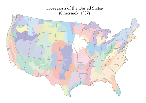
Ecoregions are based on perceived patterns of a combination of causal and integrative factors including land use, land surface form, potential natural vegetation, and soils (Omernik, 1987). This is a copy of the ecoregion coverage of Omernik (1987) with some item names modified. This is NOT the most recent version of the ecoregion definitions, which can be obtained from: Environmental Protection Agency, Western Ecology Division, Corvallis, OR at http://www.epa.gov/wed/pages/ecoregions/level_iii.htm.

These data were released prior to the October 1, 2016 effective date for the USGS’s policy dictating the review, approval, and release of scientific data as referenced in USGS Survey Manual Chapter 502.8 Fundamental Science Practices: Review and Approval of Scientific Data for Release. Ecoregions are based on perceived patterns of a combination of causal and integrative factors including land use, land surface form, potential natural vegetation, and soils (Omernik, 1987). This is a copy of the ecoregion coverage of Omernik (1987) with some item names modified. This is NOT the most recent version of the ecoregion definitions, which can be obtained from: Environmental Protection Agency, Western Ecology Division,...
Categories: pre-SM502.8;
Tags: Conterminous United States,
Conterminous United States,
EPA Ecoregion Map,
NSDI,
USGS Science Data Catalog (SDC),
|

|
