Filters: Tags: Ecosystem (X) > partyWithName: U.S. Geological Survey (X)
15 results (79ms)|
Filters
Date Range
Contacts
Categories Tag Types Tag Schemes |

These data were released prior to the October 1, 2016 effective date for the USGS’s policy dictating the review, approval, and release of scientific data as referenced in USGS Survey Manual Chapter 502.8 Fundamental Science Practices: Review and Approval of Scientific Data for Release. Estuarine ecosystems are controlled by a variety of processes that operate at multiple spatial and temporal scales. Understanding the hierarchical nature of these processes will aid in prioritization of restoration efforts. This hierarchical Columbia River Estuary Ecosystem Classification (henceforth "Classification") of the Columbia River estuary is a spatial database of the tidally-influenced reaches of the lower Columbia River,...

These data were released prior to the October 1, 2016 effective date for the USGS’s policy dictating the review, approval, and release of scientific data as referenced in USGS Survey Manual Chapter 502.8 Fundamental Science Practices: Review and Approval of Scientific Data for Release. Estuarine ecosystems are controlled by a variety of processes that operate at multiple spatial and temporal scales. Understanding the hierarchical nature of these processes will aid in prioritization of restoration efforts. This hierarchical Columbia River Estuary Ecosystem Classification (henceforth "Classification") of the Columbia River estuary is a spatial database of the tidally-influenced reaches of the lower Columbia River,...
The U.S. Geological Survey (USGS) has generated land surface form classes for the contiguous United States. These land surface form classes were created as part of an effort to map standardized, terrestrial ecosystems for the nation using a classification developed by NatureServe (Comer and others, 2003). Ecosystem distributions were modeled using a biophysical stratification approach developed for South America (Sayre and others, 2008) and now being implemented globally (Sayre and others, 2007). Land surface forms strongly influence the differentiation and distribution of terrestrial ecosystems, and are one of the key input layers in the ecosystem delineation process.The methodology used to produce these land surface...

These data were released prior to the October 1, 2016 effective date for the USGS’s policy dictating the review, approval, and release of scientific data as referenced in USGS Survey Manual Chapter 502.8 Fundamental Science Practices: Review and Approval of Scientific Data for Release. Estuarine ecosystems are controlled by a variety of processes that operate at multiple spatial and temporal scales. Understanding the hierarchical nature of these processes will aid in prioritization of restoration efforts. This hierarchical Columbia River Estuary Ecosystem Classification (henceforth "Classification") of the Columbia River estuary is a spatial database of the tidally-influenced reaches of the lower Columbia River,...
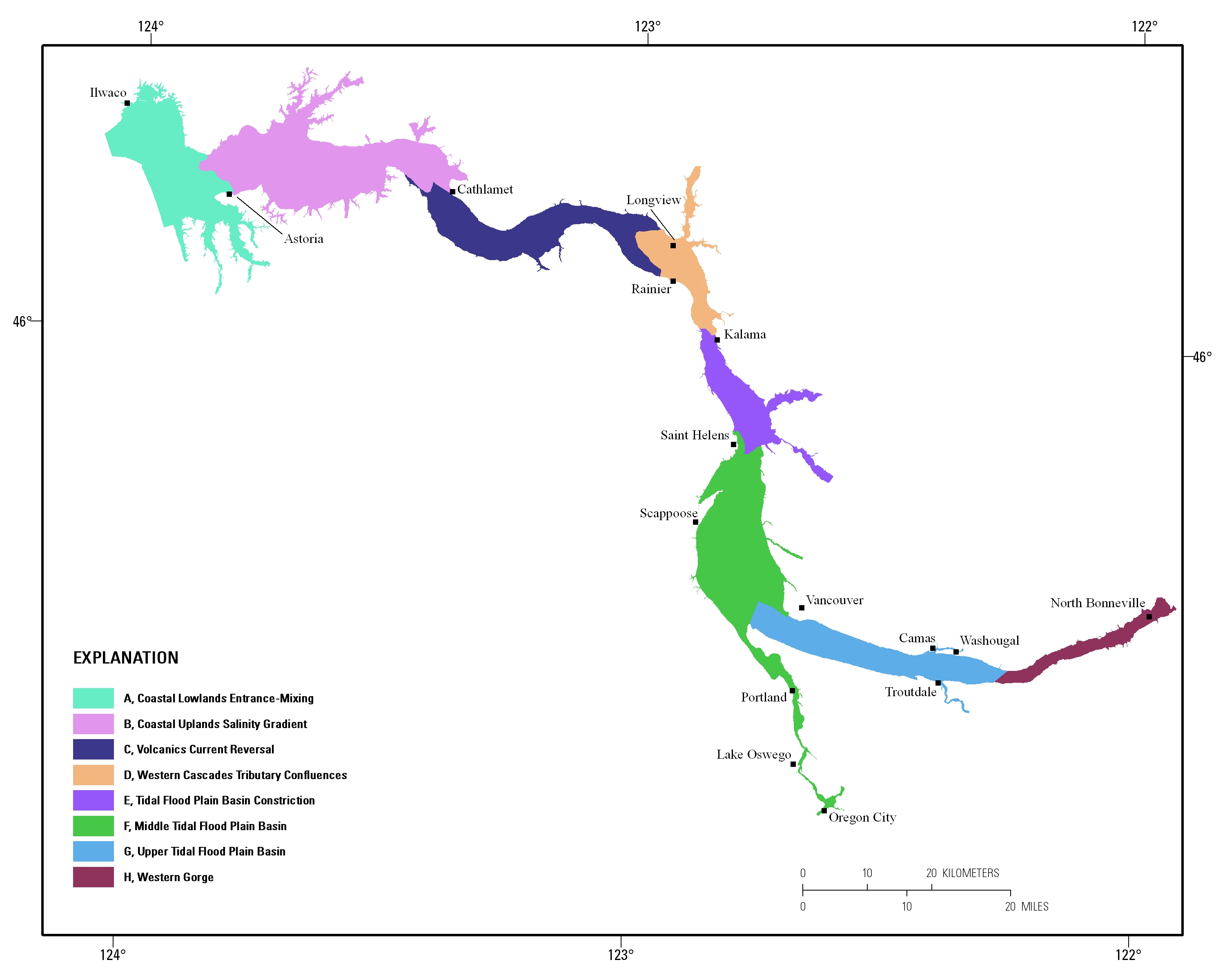
Estuarine ecosystems are controlled by a variety of processes that operate at multiple spatial and temporal scales. Understanding the hierarchical nature of these processes will aid in prioritization of restoration efforts. This hierarchical Columbia River Estuary Ecosystem Classification (henceforth "Classification") of the Columbia River estuary is a spatial database of the tidally-influenced reaches of the lower Columbia River, the tidally affected parts of its tributaries, and the landforms that make up their floodplains for the 230 kilometers between the Pacific Ocean and Bonneville Dam. This work is a collaborative effort between University of Washington School of Aquatic and Fishery Sciences (henceforth "UW"),...
This U.S. Geological Survey (USGS) data release presents the geospatial data used to assess the hydrologic resources and the potential effects from oil and gas development in the Bureau of Land Management Tri-County Planning Area, Sierra, Doña Ana, and Otero Counties, New Mexico. Publicly available data were used to assess these resources and effects and to identify data gaps in the Tri-County planning area. These data support the following publication: Blake, J.M., Miltenberger, K.E., Stewart, A.M., Ritchie, A.B., Montoya, J., Durr, C., McHugh, A.R., and Charles, E.G., in press, Assessment of Water Resources and the Potential Effects from Oil and Gas Development in the Bureau of Land Management Tri-County Planning...
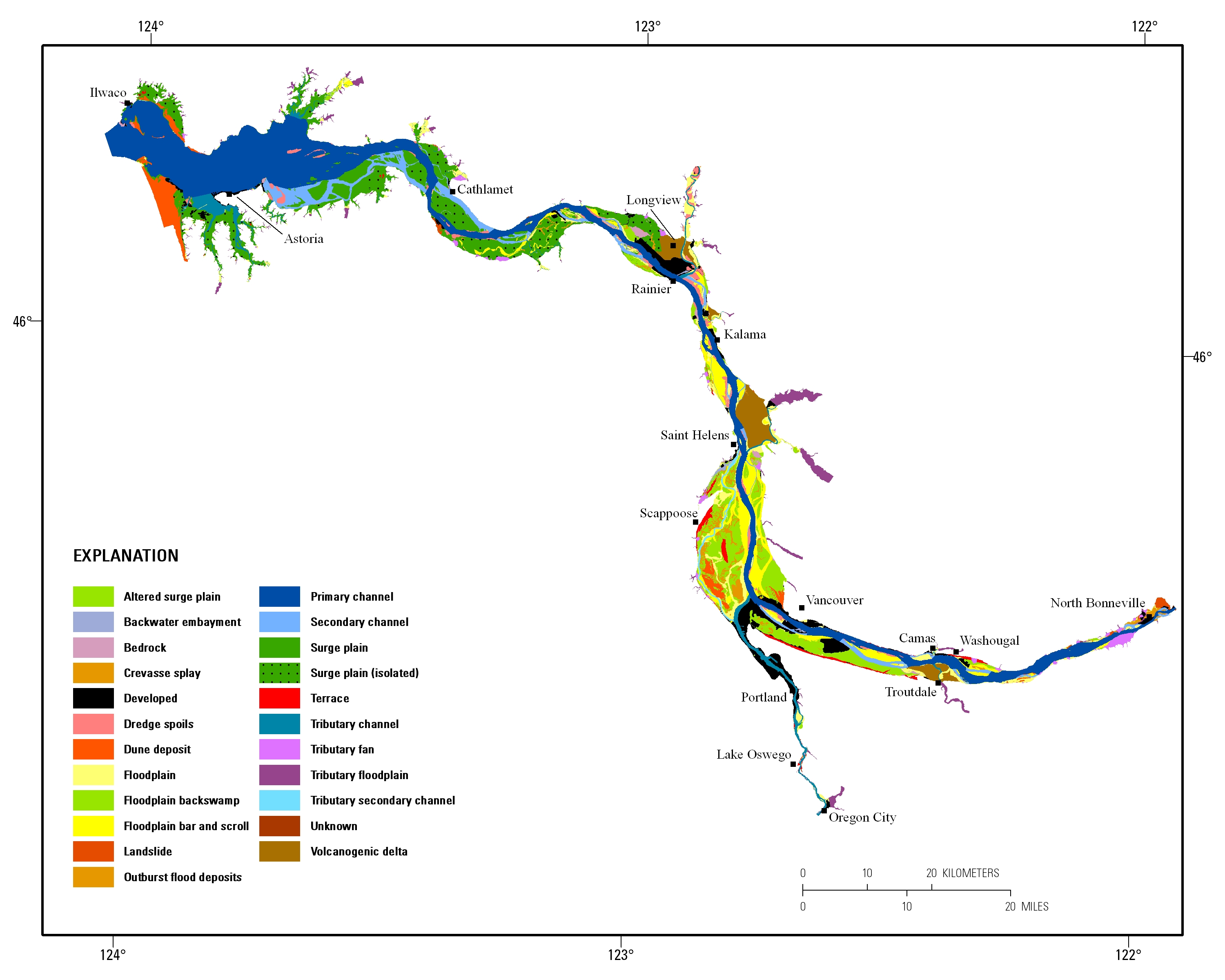
Estuarine ecosystems are controlled by a variety of processes that operate at multiple spatial and temporal scales. Understanding the hierarchical nature of these processes will aid in prioritization of restoration efforts. This hierarchical Columbia River Estuary Ecosystem Classification (henceforth "Classification") of the Columbia River estuary is a spatial database of the tidally-influenced reaches of the lower Columbia River, the tidally affected parts of its tributaries, and the landforms that make up their floodplains for the 230 kilometers between the Pacific Ocean and Bonneville Dam. This work is a collaborative effort between University of Washington School of Aquatic and Fishery Sciences (henceforth "UW"),...

These data were released prior to the October 1, 2016 effective date for the USGS’s policy dictating the review, approval, and release of scientific data as referenced in USGS Survey Manual Chapter 502.8 Fundamental Science Practices: Review and Approval of Scientific Data for Release. This point feature class contains 81,481 points arranged in a 270-meter spaced grid that covers the Spring Mountains and Sheep Range in Clark County, Nevada. Points are attributed with hydroclimate variables and ancillary data compiled to support efforts to characterize ecological zones.

These data were released prior to the October 1, 2016 effective date for the USGS’s policy dictating the review, approval, and release of scientific data as referenced in USGS Survey Manual Chapter 502.8 Fundamental Science Practices: Review and Approval of Scientific Data for Release. Estuarine ecosystems are controlled by a variety of processes that operate at multiple spatial and temporal scales. Understanding the hierarchical nature of these processes will aid in prioritization of restoration efforts. This hierarchical Columbia River Estuary Ecosystem Classification (henceforth "Classification") of the Columbia River estuary is a spatial database of the tidally-influenced reaches of the lower Columbia River,...
Categories: pre-SM502.8;
Tags: Clackamas County,
Clark County,
Clatsop County,
Columbia County,
Columbia River,
Contemporary climate change in Alaska has resulted in amplified rates of press and pulse disturbances that drive ecosystem change with significant consequences for socio-environmental systems. Despite the vulnerability of Arctic and boreal landscapes to change, little has been done to characterize landscape change and associated drivers across northern high-latitude ecosystems. Here we characterize the historical sensitivity of Alaska’s ecosystems to environmental change and anthropogenic disturbances using expert knowledge, remote sensing data, and spatiotemporal analyses and modeling. Time-series analysis of moderate– and high-resolution imagery was used to characterize land and water-surface dynamics across Alaska....
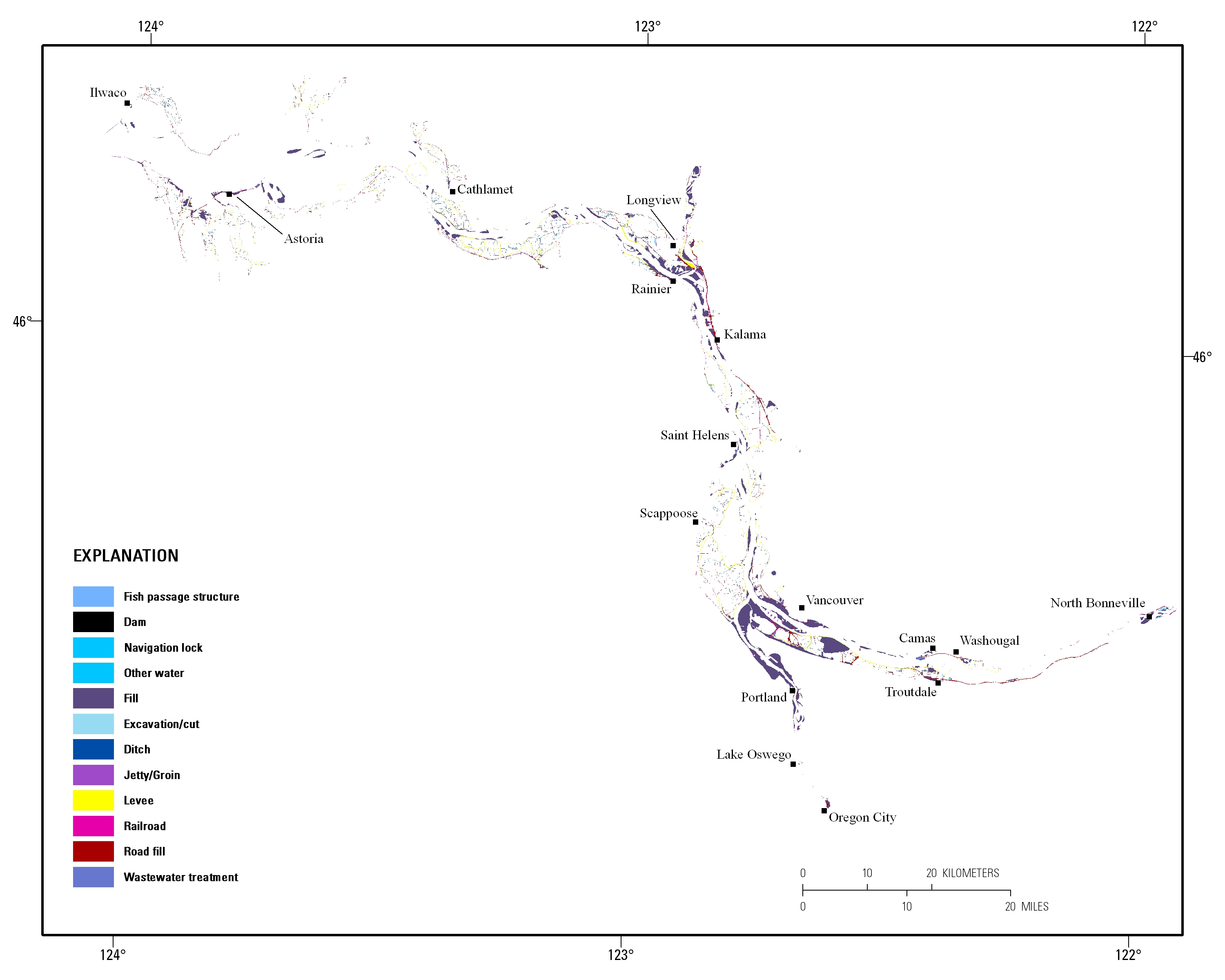
Estuarine ecosystems are controlled by a variety of processes that operate at multiple spatial and temporal scales. Understanding the hierarchical nature of these processes will aid in prioritization of restoration efforts. This hierarchical Columbia River Estuary Ecosystem Classification (henceforth "Classification") of the Columbia River estuary is a spatial database of the tidally-influenced reaches of the lower Columbia River, the tidally affected parts of its tributaries, and the landforms that make up their floodplains for the 230 kilometers between the Pacific Ocean and Bonneville Dam. This work is a collaborative effort between University of Washington School of Aquatic and Fishery Sciences (henceforth "UW"),...
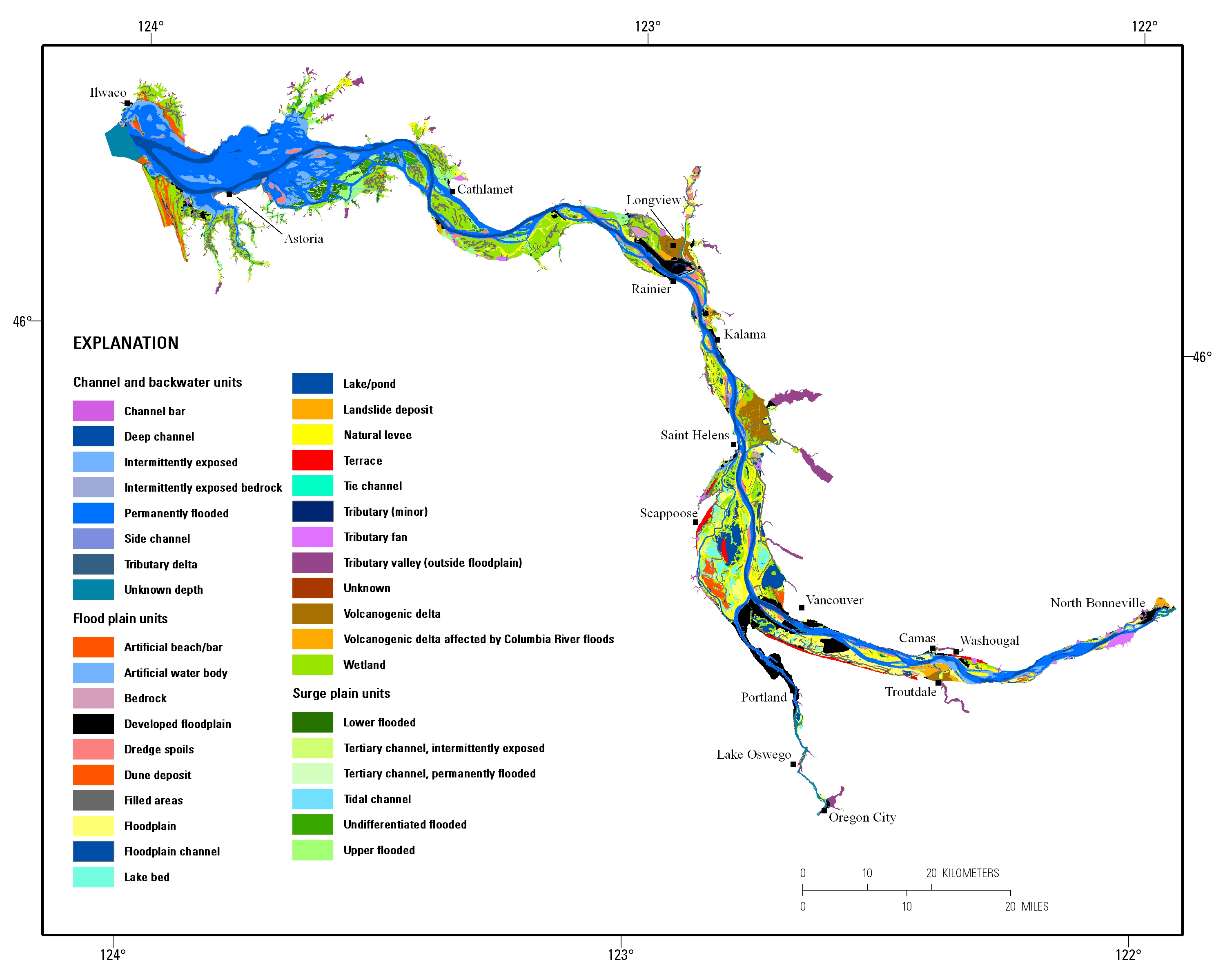
Estuarine ecosystems are controlled by a variety of processes that operate at multiple spatial and temporal scales. Understanding the hierarchical nature of these processes will aid in prioritization of restoration efforts. This hierarchical Columbia River Estuary Ecosystem Classification (henceforth "Classification") of the Columbia River estuary is a spatial database of the tidally-influenced reaches of the lower Columbia River, the tidally affected parts of its tributaries, and the landforms that make up their floodplains for the 230 kilometers between the Pacific Ocean and Bonneville Dam. This work is a collaborative effort between University of Washington School of Aquatic and Fishery Sciences (henceforth "UW"),...
The U.S. Geological Survey (USGS) has generated and mapped isobioclimate classes for the contiguous United States. These isobioclimate classes were created as part of an effort to map standardized, terrestrial ecosystems for the nation using a classification developed by NatureServe (Comer and others, 2003). Ecosystem distributions were modeled using a biophysical stratification approach developed for South America (Sayre and others, 2008) and now being implemented globally (Sayre and others, 2007). Bioclimate regimes strongly influence the differentiation and distribution of terrestrial ecosystems, and are one of the key input layers in the ecosystem delineation process.The Rivas-Martínez methodology used to produce...
The U.S. Geological Survey (USGS) has generated topographic moisture potential classes for the contiguous United States. These topographic moisture potential classes were created as part of an effort to map standardized, terrestrial ecosystems for the nation using a classification developed by NatureServe (Comer and others, 2003). Ecosystem distributions were modeled using a biophysical stratification approach developed for South America (Sayre and others, 2008) and now being implemented globally (Sayre and others, 2007). Substrate moisture regimes strongly influence the differentiation and distribution of terrestrial ecosystems, and are one of the key input layers in the ecosystem delineation process. The method...
The U.S. Geological Survey (USGS) has generated a new classification and map of the lithology of surficial materials for the contiguous United States. This was developed as part of an effort to map standardized, terrestrial ecosystem distributions for the nation using a classification developed by NatureServe (Comer and others, 2003). This ecosystem mapping methodology, which delineates ecosystems by mapping and integrating their major structural components, was first developed for South America (Sayre and others, 2008) and is now being implemented globally (Sayre and others, 2007). Surficial lithology strongly influences the differentiation and distribution of terrestrial ecosystems, and is one of the key input...
|

|
