Filters: Tags: Evapotranspiration (X)
531 results (5ms)|
Filters
|
This USGS Data Release supports USGS Scientific Investigations Report (SIR) 2017-5079. Following is the abstract from SIR 2017-5079: This report documents methodology and results of a study to evaluate groundwater discharge by evapotranspiration (GWET) in sparsely vegetated areas of Amargosa Desert and improve understanding of hydrologic-continuum processes controlling groundwater discharge. Evapotranspiration and GWET rates were computed and characterized at three sites over 2 years using a combination of micrometeorological, unsaturated zone, and stable-isotope measurements. One site (Amargosa Flat Shallow [AFS]) was in a sparse and isolated area of saltgrass (Distichlis spicata) where the depth to groundwater...
Categories: Data;
Types: Citation;
Tags: Amargosa Desert,
Amargosa Flat,
Evapotranspiration,
Groundwater levels,
Nevada,
The data in this release describe various aspects of the impacts of urbanization on evapotranspiration at local to global spatial scales. This data release is associated with the publication of these results in a concurrent journal article. Analyses in the journal article included comparisons between urban and non-urban ET in a variety of climate settings and spatial scales. Urbanization has been shown to locally increase the nighttime temperatures creating urban heat islands, which partly arise due to evapotranspiration (ET) reduction. It is unclear how the direction and magnitude of the change in local ET due to urbanization varies globally across different climatic regimes. This knowledge gap is critical, both...
Categories: Data;
Tags: Land Use Change,
Remote Sensing,
USGS Science Data Catalog (SDC),
World,
evapotranspiration,

This dataset is a Basin Characterization Model (BCM) output using the PCM A2 Scenario for annual recharge, 2010-2039, clipped to the DRECP 12 km buffered boundary. Recharge: Amount of water exceeding field capacity that enters bedrock, occurs at a rate determined by the hydraulic conductivity of the underlying materials, excess water (rejected recharge) is added to runoff. The California Basin Characterization Model (BCM) climate dataset provides historical and projected climate surfaces for the state at a 270 meter resolution. The historical data is based on 4 kilometer PRISM data, and the projected climate surfaces are based on the A2 and B1 scenarios of the PCM and GFDL GCMs. The BCM approach uses a regional...
The NRP had its beginnings in the late 1950's. Since that time, the program has grown to encompass a broad spectrum of scientific investigations. The sciences of hydrology, mathematics, chemistry, physics, ecology, biology, geology, and engineering are used to gain a fundamental understanding of the processes that affect the availability, movement, and quality of the Nation's water resources. Results of NRP's long-term research investigations often lead to the development of new concepts, techniques, and approaches that are applicable not only to the solution of current water problems, but also to future issues that may affect the Nation's water resources. Basic tools of hydrology that have been developed by the...
Categories: Project;
Types: ScienceBase Project;
Tags: Acid Mine Drainage,
Aquatic Habitat,
Arid Land Hydrology,
Carbon Cycle,
Contaminant Reactions and Transport,
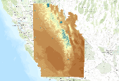
This dataset is a Basin Characterization Model (BCM) output using the GFDL A2 Scenario for Climatic Water Deficit (CWD) in southern Sierra Nevada California, for 2010-2039. The term climatic water deficit defined by Stephenson (1998) is quantified as the amount of water by which potential evapotranspiration (PET) exceeds actual evapotranspiration (AET). This term effectively integrates the combined effects of solar radiation, evapotranspiration, and air temperature on watershed conditions given available soil moisture derived from precipitation. Climatic water deficit can be thought of as the amount of additional water that would have evaporated or transpired had it been present in the soils given the temperature...

This dataset is a Basin Characterization Model (BCM) output using the PCM A2 Scenario for annual Climatic Water Deficit (CWD), 2070-2099, clipped to the DRECP 12 km buffered boundary. The term climatic water deficit defined by Stephenson (1998) is quantified as the amount of water by which potential evapotranspiration (PET) exceeds actual evapotranspiration (AET). This term effectively integrates the combined effects of solar radiation, evapotranspiration, and air temperature on watershed conditions given available soil moisture derived from precipitation. Climatic water deficit can be thought of as the amount of additional water that would have evaporated or transpired had it been present in the soils given the...

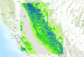
This dataset is a Basin Characterization Model (BCM) output using the PCM A2 Scenario for average Spring (March, April, May) snowpack, in central Sierra Nevada California, for 2040-2069. Snowpack: Amount of snow accumulated per month summed annually, or if divided by 12 average monthly snowpack. This is calculated as prior month's snowpack plus snowfall minus sublimation and snow melt. The California Basin Characterization Model (BCM) climate dataset provides historical and projected climate surfaces for the state at a 270 meter resolution. The historical data is based on 4 kilometer PRISM data, and the projected climate surfaces are based on the A2 and B1 scenarios of the PCM and GFDL GCMs. The BCM approach uses...
This dataset is a Basin Characterization Model (BCM) output using the GFDL A2 Scenario for Runoff, in central Sierra Nevada California, for 2040-2069. Runoff: Amount of water that becomes stream flow, summed annually. Modeled as amount of water that exceeds total soil storage and rejected recharge. The California Basin Characterization Model (BCM) climate dataset provides historical and projected climate surfaces for the state at a 270 meter resolution. The historical data is based on 4 kilometer PRISM data, and the projected climate surfaces are based on the A2 and B1 scenarios of the PCM and GFDL GCMs. The BCM approach uses a regional water balance model based on high resolution downscaled precipitation and...
Evapotranspiration rates and the ground water component of evapotranspiration at a site in Colorado's San Luis Valley that is dominated by shrubby phreatophytes (greasewood and rabbitbrush) were compared before and after a water table drawdown. Evapotranspiration (ET) rates at the site were first measured in 1985–1987 (pre-drawdown) when the mean water table depth was 0.92 m. Regional ground water pumping has since lowered the water table by 1.58 m, to a mean of 2.50 m. We measured ET at the same site in 1999–2003 (post-drawdown), and assessed physical and biological factors affecting the response of ET to water table drawdown. Vegetation changed markedly from the pre-drawdown to the post-drawdown period as phreatophytic...
Categories: Publication;
Types: Citation;
Tags: Evapotranspiration,
Ground water,
Phreatophytes,
San
Evapotranspiration determined using the energy-budget method at a semi-permanent prairie-pothole wetland in east-central North Dakota, USA was compared with 12 other commonly used methods. The Priestley-Taylor and deBruin-Keijman methods compared best with the energy-budget values; mean differences were less than 0.1 mm d−1, and standard deviations were less than 0.3 mm d−1. Both methods require measurement of air temperature, net radiation, and heat storage in the wetland water. The Penman, Jensen-Haise, and Brutsaert-Stricker methods provided the next-best values for evapotranspiration relative to the energy-budget method. The mass-transfer, deBruin, and Stephens-Stewart methods provided the worst comparisons;...
Categories: Publication;
Types: Citation;
Tags: energy budget,
evaporation,
evapotranspiration,
metho
In dryland ecosystems, the timing and magnitude of precipitation pulses drive many key ecological processes, notably soil water availability for plants and soil microbiota. Plant available water has frequently been viewed simply as incoming precipitation, yet processes at larger scales drive precipitation pulses, and the subsequent transformation of precipitation pulses to plant available water are complex. We provide an overview of the factors that influence the spatial and temporal availability of water to plants and soil biota using examples from western USA drylands. Large spatial- and temporal-scale drivers of regional precipitation patterns include the position of the jet streams and frontal boundaries, the...
Categories: Publication;
Types: Citation,
Journal Citation;
Tags: Drought duration,
El Niño Southern Oscillation,
Evapotranspiration,
Infiltration depth,
Oecologia,
Non-native shrub species in the genus Tamarix (saltcedar, tamarisk) have colonized hundreds of thousands of hectares of floodplains, reservoir margins, and other wetlands in western North America. Many resource managers seek to reduce saltcedar abundance and control its spread to increase the flow of water in streams that might otherwise be lost to evapotranspiration, to restore native riparian (streamside) vegetation, and to improve wildlife habitat. However, increased water yield might not always occur and has been substantially lower than expected in water salvage experiments, the potential for successful revegetation is variable, and not all wildlife taxa clearly prefer native plant habitats over saltcedar....
Categories: Publication;
Types: Citation,
Journal Citation;
Tags: Control,
Environmental Management,
Evapotranspiration,
Exotic species,
Invasive species,

This dataset is a Basin Characterization Model (BCM) output using the GFDL A2 Scenario for average Spring (March, April, May) snowpack change, 2010-2039, clipped to the Sierra Nevada Zone for CA LCC. Snowpack: Amount of snow accumulated per month summed annually, or if divided by 12 average monthly snowpack. This is calculated as prior month's snowpack plus snowfall minus sublimation and snow melt.Snowpack change was calculated using GFDL A2 scenario 2010-2039 minus Historic Snowpack 1971-2000. The California Basin Characterization Model (BCM) climate dataset provides historical and projected climate surfaces for the state at a 270 meter resolution. The historical data is based on 4 kilometer PRISM data, and the...

This dataset is a Basin Characterization Model (BCM) output using the GFDL A2 Scenario calculated to represent percentage of annual precipitation received during summer months (June, July, August and September), 2040-2069, clipped to the DRECP 12 km buffered boundary.Total Precipitation:Â Total monthly precipitation (rain or snow), also summed by water year. Averaged over 30 year ranges.Calculation of Percentage: Summer Months Precipitation (June, July, August, September)/Annual Precipitation. The California Basin Characterization Model (BCM) climate dataset provides historical and projected climate surfaces for the state at a 270 meter resolution. The historical data is based on 4 kilometer PRISM data, and the...

This dataset is a Basin Characterization Model (BCM) output using the GFDL A2 Scenario for annual Minimum Temperature, 2070-2099, clipped to the DRECP 12 km buffered boundary.Minimum Temperature:Â The modeled daily maximum and minimum are averaged to give daily average; the minimum daily average in a calendar month becomes the monthly minimum; this is averaged over a 30 year period to determine TMin for each month of the year, and for the water year. The California Basin Characterization Model (BCM) climate dataset provides historical and projected climate surfaces for the state at a 270 meter resolution. The historical data is based on 4 kilometer PRISM data, and the projected climate surfaces are based on the...

This dataset represents Recharge change, from Basin Characterization Model (BCM) output using the PCM A2 Scenario in southern California, for 2070-2099. The data was processed using historic Recharge (1979-2000) and PCM A2 Scenario Recharge (2070-2099) to calculate change. Recharge: Amount of water exceeding field capacity that enters bedrock, occurs at a rate determined by the hydraulic conductivity of the underlying materials, excess water (rejected recharge) is added to runoff. The California Basin Characterization Model (BCM) climate dataset provides historical and projected climate surfaces for the state at a 270 meter resolution. The historical data is based on 4 kilometer PRISM data, and the projected...

This dataset is a Basin Characterization Model (BCM) output using the PCM A2 Scenario for annual runoff, 2040-2069, clipped to the DRECP 12 km buffered boundary. Runoff: Amount of water that becomes stream flow, summed annually. Modeled as amount of water that exceeds total soil storage and rejected recharge. The California Basin Characterization Model (BCM) climate dataset provides historical and projected climate surfaces for the state at a 270 meter resolution. The historical data is based on 4 kilometer PRISM data, and the projected climate surfaces are based on the A2 and B1 scenarios of the PCM and GFDL GCMs. The BCM approach uses a regional water balance model based on high resolution downscaled precipitation...

This dataset is historic annual runoff, for 1971-2000, clipped to the DRECP 12 km buffered boundary from the California Basin Characterization Model (BCM) Runoff: Amount of water that becomes stream flow, summed annually. Modeled as amount of water that exceeds total soil storage and rejected recharge. The California Basin Characterization Model (BCM) climate dataset provides historical and projected climate surfaces for the state at a 270 meter resolution. The historical data is based on 4 kilometer PRISM data, and the projected climate surfaces are based on the A2 and B1 scenarios of the PCM and GFDL GCMs. The BCM approach uses a regional water balance model based on high resolution downscaled precipitation...
The evapotranspiration (ET) datasets were created under contract for this study by the University of Idaho. A high-resolution remote sensing technique known as Mapping Evapotranspiration at High Resolution and Internalized Calibration (METRIC) was used to create estimates of the spatial distribution of ET. The METRIC technique uses thermal infrared Landsat imagery to quantify actual evapotranspiration at a 30-meter resolution that can be related to individual irrigated fields. Because evaporation uses heat energy, ground surfaces with large ET rates are left cooler as a result of ET than ground surfaces that have less ET. As a consequence, irrigated fields appear in the Landsat images as cooler than nonirrigated...

This dataset is a Basin Characterization Model (BCM) output using the PCM A2 Scenario for average Spring (March, April, May) snowpack, 2010-2039, clipped to the DRECP 12 km buffered boundary. Snowpack: Amount of snow accumulated per month summed annually, or if divided by 12 average monthly snowpack. This is calculated as prior month's snowpack plus snowfall minus sublimation and snow melt. The California Basin Characterization Model (BCM) climate dataset provides historical and projected climate surfaces for the state at a 270 meter resolution. The historical data is based on 4 kilometer PRISM data, and the projected climate surfaces are based on the A2 and B1 scenarios of the PCM and GFDL GCMs. The BCM approach...
|

|
