Filters: Tags: FRONTIER (X)
460 results (97ms)|
Filters
Date Range
Extensions Types Contacts
Categories Tag Types Tag Schemes |
Core Research Center, core T357, from well operated by MOUNTAIN FUELRaw Properties from download, web scrape, MapServer, and Macrostrat API{"Lib Num": "T357", "API Num": "4904121242", "Operator": "MOUNTAIN FUEL", "Well Name": "CHURCH BUTTES UNIT 28", "Field": "CHURCH BUTTES", "State": "WY", "County": "UINTA", "Type": "FULL", "Photos": "F", "Thin Sec": "F", "Analysis": "F", "Latitude": "41.39163", "Longitude": "-110.05539", "coordinates_geohash": "9x3erxh5ex16", "Source": "PROVIDED BY DONOR", "Security Flag": "NO SPECIAL RESTRICTIONS", "crc_collection_name": "core", "sb_parent_id": "4f4e49dae4b07f02db5e0486", "intervals": [{"Formation": "FRONTIER", "Age": "CRETACEOUS", "Min Depth": "12058", "Max Depth": "12120"}],...
Core Research Center, core T024, from well operated by PETROLEUM CORP OF AMRaw Properties from download, web scrape, MapServer, and Macrostrat API{"Lib Num": "T024", "API Num": null, "Operator": "PETROLEUM CORP OF AM", "Well Name": "14A", "Field": "SHERARD DOME", "State": "WY", "County": "WASHAKIE", "Type": "FULL", "Photos": "T", "Thin Sec": "F", "Analysis": "F", "Latitude": "44.0309", "Longitude": "-107.59544", "coordinates_geohash": "9xg6rxe6sd9j", "Source": "CENTER OF SECTION", "Security Flag": "NO SPECIAL RESTRICTIONS", "crc_collection_name": "core", "sb_parent_id": "4f4e49dae4b07f02db5e0486", "intervals": [{"Formation": "FRONTIER", "Age": "CRET", "Min Depth": "70", "Max Depth": "110"}], "crcwc_url": "https://my.usgs.gov/crcwc/core/report/15940",...
Core Research Center, core B224, from well operated by C & K PETROLEUMRaw Properties from download, web scrape, MapServer, and Macrostrat API{"Lib Num": "B224", "API Num": "4903721118", "Operator": "C & K PETROLEUM", "Well Name": "6 LINCOLN ROAD UNIT", "Field": "LINCOLN ROAD", "State": "WY", "County": "SWEETWATER", "Type": "SLABBED", "Photos": "T", "Thin Sec": "T", "Analysis": "T", "Latitude": "42.05597", "Longitude": "-110.01251", "coordinates_geohash": "9x3z2853f9nb", "Source": "FROM STATE RECORDS", "Security Flag": "NO SPECIAL RESTRICTIONS", "crc_collection_name": "core", "sb_parent_id": "4f4e49dae4b07f02db5e0486", "intervals": [{"Formation": "FRONTIER", "Age": "CRET", "Min Depth": "9945", "Max Depth": "10009"},...
Core Research Center, core S642, from well operated by CHEVRON OILRaw Properties from download, web scrape, MapServer, and Macrostrat API{"Lib Num": "S642", "API Num": "4900105175", "Operator": "CHEVRON OIL", "Well Name": "1 GEORGE GOVERNMENT", "Field": "JAMES LAKE", "State": "WY", "County": "ALBANY", "Type": "FULL", "Photos": "F", "Thin Sec": "F", "Analysis": "F", "Latitude": "41.47685", "Longitude": "-105.83232", "coordinates_geohash": "9xkezwxk0jnx", "Source": "FROM STATE RECORDS", "Security Flag": "NO SPECIAL RESTRICTIONS", "crc_collection_name": "core", "sb_parent_id": "4f4e49dae4b07f02db5e0486", "intervals": [{"Formation": "LAKOTA", "Age": "CRET", "Min Depth": "4542", "Max Depth": "4594"}, {"Formation": "SUNDANCE",...
Core Research Center, core F050, from well operated by WOODS PETROLEUMRaw Properties from download, web scrape, MapServer, and Macrostrat API{"Lib Num": "F050", "API Num": "4900922609", "Operator": "WOODS PETROLEUM", "Well Name": "7-1 CITIES FEDERAL", "Field": "NORTH POWELL", "State": "WY", "County": "CONVERSE", "Type": "SLABBED", "Photos": "T", "Thin Sec": "F", "Analysis": "T", "Latitude": "43.45414", "Longitude": "-105.79091", "coordinates_geohash": "9xsz0wt6tnu1", "Source": "FROM STATE RECORDS", "Security Flag": "NO SPECIAL RESTRICTIONS", "crc_collection_name": "core", "sb_parent_id": "4f4e49dae4b07f02db5e0486", "intervals": [{"Formation": "FRONTIER", "Age": "CRET", "Min Depth": "13233", "Max Depth": "13293"},...
Core Research Center, core A642, from well operated by AMOCO PRODUCTIONRaw Properties from download, web scrape, MapServer, and Macrostrat API{"Lib Num": "A642", "API Num": "4904120056", "Operator": "AMOCO PRODUCTION", "Well Name": "228-A-1 CHAMPLIN", "Field": "WILDCAT", "State": "WY", "County": "UINTA", "Type": "SLABBED", "Photos": "T", "Thin Sec": "T", "Analysis": "T", "Latitude": "41.50708", "Longitude": "-110.19372", "coordinates_geohash": "9x3shkpkk0x0", "Source": "FROM STATE RECORDS", "Security Flag": "NO SPECIAL RESTRICTIONS", "crc_collection_name": "core", "sb_parent_id": "4f4e49dae4b07f02db5e0486", "intervals": [{"Formation": "FRONTIER", "Age": "CRET", "Min Depth": "12126", "Max Depth": "12180"}], "crcwc_url":...
Categories: Physical Item;
Tags: Bridger B, Bridger Formation,
Bridger Formation,
CRET,
FRONTIER,
claystone,
Core Research Center, core D500, from well operated by CELSIUS ENERGYRaw Properties from download, web scrape, MapServer, and Macrostrat API{"Lib Num": "D500", "API Num": "4904120719", "Operator": "CELSIUS ENERGY", "Well Name": "12-1 THOMPSON-FEDERAL", "Field": "CHURCH BUTTES", "State": "WY", "County": "UINTA", "Type": "SLABBED", "Photos": "T", "Thin Sec": "T", "Analysis": "T", "Latitude": "41.47111", "Longitude": "-110.12739", "coordinates_geohash": "9x3evvxdtz4p", "Source": "FROM STATE RECORDS", "Security Flag": "NO SPECIAL RESTRICTIONS", "crc_collection_name": "core", "sb_parent_id": "4f4e49dae4b07f02db5e0486", "intervals": [{"Formation": "FRONTIER", "Age": "CRET", "Min Depth": "12177", "Max Depth": "12237"}],...
Core Research Center, core E490, from well operated by GENERAL ATLANTICRaw Properties from download, web scrape, MapServer, and Macrostrat API{"Lib Num": "E490", "API Num": "4903722540", "Operator": "GENERAL ATLANTIC", "Well Name": "23-4 BLUE FOREST UNIT", "Field": "BLUE FOREST", "State": "WY", "County": "SWEETWATER", "Type": "SLABBED", "Photos": "T", "Thin Sec": "T", "Analysis": "T", "Latitude": "42.08597", "Longitude": "-109.89902", "coordinates_geohash": "9x3z7jtbx1rm", "Source": "FROM STATE RECORDS", "Security Flag": "NO SPECIAL RESTRICTIONS", "crc_collection_name": "core", "sb_parent_id": "4f4e49dae4b07f02db5e0486", "intervals": [{"Formation": "FRONTIER", "Age": "CRET", "Min Depth": "10583", "Max Depth": "10633"},...
Core Research Center, core S070, from well operated by WEXPRORaw Properties from download, web scrape, MapServer, and Macrostrat API{"Lib Num": "S070", "API Num": "4901920259", "Operator": "WEXPRO", "Well Name": "KNEBEL 1-9", "Field": "TRABING", "State": "WY", "County": "JOHNSON", "Type": "THIN SLAB", "Photos": "F", "Thin Sec": "F", "Analysis": "F", "Latitude": "43.968781", "Longitude": "-106.478948", "coordinates_geohash": "9xu61h22swvg", "Source": "PROVIDED BY DONOR", "Security Flag": null, "crc_collection_name": "core", "sb_parent_id": "4f4e49dae4b07f02db5e0486", "intervals": [{"Formation": "FRONTIER", "Age": "CRETACEOUS", "Min Depth": "12644", "Max Depth": "12655"}, {"Formation": "UNKNOWN", "Age": "CRETACEOUS",...
Categories: Physical Item;
Tags: CRETACEOUS,
CRETACEOUS,
Eocene and Paleocene?,
FRONTIER,
Wasatch Formation,
Core Research Center, core B607, from well operated by UNION OILRaw Properties from download, web scrape, MapServer, and Macrostrat API{"Lib Num": "B607", "API Num": "4902521219", "Operator": "UNION OIL", "Well Name": "35-D11 WEST POISON SPIDER", "Field": "WEST POISON SPIDER", "State": "WY", "County": "NATRONA", "Type": "SLABBED", "Photos": "T", "Thin Sec": "F", "Analysis": "T", "Latitude": "42.8504", "Longitude": "-106.88299", "coordinates_geohash": "9xegzbdjtvd0", "Source": "FROM STATE RECORDS", "Security Flag": "NO SPECIAL RESTRICTIONS", "crc_collection_name": "core", "sb_parent_id": "4f4e49dae4b07f02db5e0486", "intervals": [{"Formation": "FRONTIER", "Age": "CRET", "Min Depth": "14473", "Max Depth": "14543"},...
Core Research Center, core E886, from well operated by BELCO PETROLEUMRaw Properties from download, web scrape, MapServer, and Macrostrat API{"Lib Num": "E886", "API Num": "4902305077", "Operator": "BELCO PETROLEUM", "Well Name": "3 EMIGRANT SPRINGS UNIT", "Field": "EMIGRANT SPRINGS", "State": "WY", "County": "LINCOLN", "Type": "SLABBED", "Photos": "T", "Thin Sec": "T", "Analysis": "F", "Latitude": "41.96916", "Longitude": "-110.09927", "coordinates_geohash": "9x3wy8k0j46p", "Source": "FROM STATE RECORDS", "Security Flag": "NO SPECIAL RESTRICTIONS", "crc_collection_name": "core", "sb_parent_id": "4f4e49dae4b07f02db5e0486", "intervals": [{"Formation": "FRONTIER", "Age": "CRET", "Min Depth": "10452", "Max Depth":...
Core Research Center, core E887, from well operated by BELCO PETROLEUMRaw Properties from download, web scrape, MapServer, and Macrostrat API{"Lib Num": "E887", "API Num": "4902305075", "Operator": "BELCO PETROLEUM", "Well Name": "4 EMIGRANT SPRINGS UNIT", "Field": "EMIGRANT SPRINGS", "State": "WY", "County": "LINCOLN", "Type": "SLABBED", "Photos": "T", "Thin Sec": "T", "Analysis": "F", "Latitude": "41.9385", "Longitude": "-110.0776", "coordinates_geohash": "9x3wx4evqp03", "Source": "FROM STATE RECORDS", "Security Flag": "NO SPECIAL RESTRICTIONS", "crc_collection_name": "core", "sb_parent_id": "4f4e49dae4b07f02db5e0486", "intervals": [{"Formation": "FRONTIER", "Age": "CRET", "Min Depth": "10624", "Max Depth": "10652"}],...
Categories: Physical Item;
Tags: Bridger A, Bridger Formation,
Bridger Formation,
CRET,
FRONTIER,
claystone,
Core Research Center, core T206, from well operated by MOUNTAIN FUEL SUPPLYRaw Properties from download, web scrape, MapServer, and Macrostrat API{"Lib Num": "T206", "API Num": "4900920733", "Operator": "MOUNTAIN FUEL SUPPLY", "Well Name": "1-5 FED SPEARHEAD RANCH", "Field": "SPEARHEAD RANGH", "State": "WY", "County": "CONVERSE", "Type": "THICK SLAB", "Photos": "T", "Thin Sec": "T", "Analysis": "F", "Latitude": "43.29973", "Longitude": "-105.77651", "coordinates_geohash": "9xsy2frzhwtw", "Source": "FROM STATE RECORDS", "Security Flag": "NO SPECIAL RESTRICTIONS", "crc_collection_name": "core", "sb_parent_id": "4f4e49dae4b07f02db5e0486", "intervals": [{"Formation": "FRONTIER", "Age": "CRET", "Min Depth": "12706",...
Core Research Center, core T038, from well operated by WOODS PETROLEUMRaw Properties from download, web scrape, MapServer, and Macrostrat API{"Lib Num": "T038", "API Num": "4900922538", "Operator": "WOODS PETROLEUM", "Well Name": "1 KEENAN RANCH", "Field": "WILDCAT", "State": "WY", "County": "CONVERSE", "Type": "SLABBED", "Photos": "T", "Thin Sec": "T", "Analysis": "T", "Latitude": "43.02613", "Longitude": "-105.75194", "coordinates_geohash": "9xsuc89v35yn", "Source": "FROM STATE RECORDS", "Security Flag": "NO SPECIAL RESTRICTIONS", "crc_collection_name": "core", "sb_parent_id": "4f4e49dae4b07f02db5e0486", "intervals": [{"Formation": "FRONTIER", "Age": "CRET", "Min Depth": "13275", "Max Depth": "13398"}], "crcwc_url":...
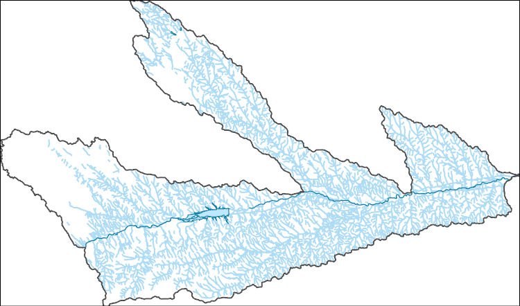
The National Hydrography Dataset (NHD) is a feature-based database that interconnects and uniquely identifies the stream segments or reaches that make up the nation's surface water drainage system. NHD data was originally developed at 1:100,000-scale and exists at that scale for the whole country. This high-resolution NHD, generally developed at 1:24,000/1:12,000 scale, adds detail to the original 1:100,000-scale NHD. (Data for Alaska, Puerto Rico and the Virgin Islands was developed at high-resolution, not 1:100,000 scale.) Local resolution NHD is being developed where partners and data exist. The NHD contains reach codes for networked features, flow direction, names, and centerline representations for areal water...
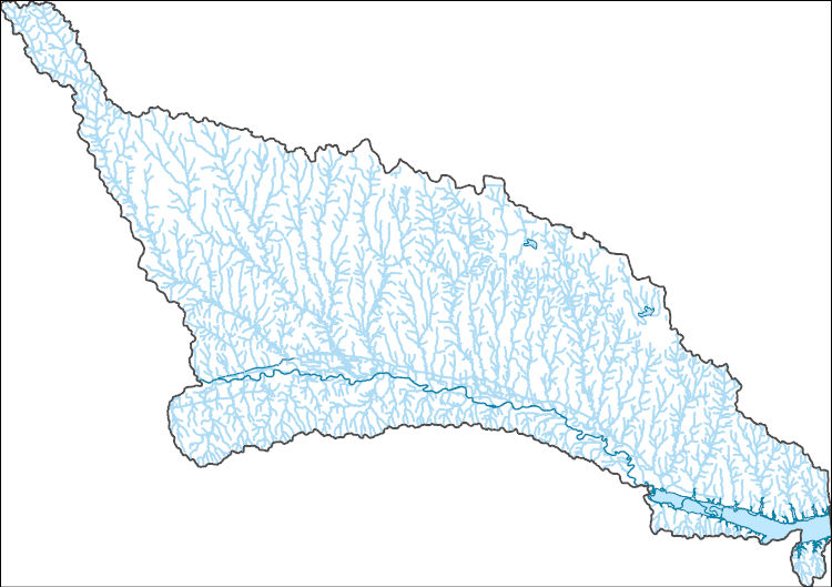
The National Hydrography Dataset (NHD) is a feature-based database that interconnects and uniquely identifies the stream segments or reaches that make up the nation's surface water drainage system. NHD data was originally developed at 1:100,000-scale and exists at that scale for the whole country. This high-resolution NHD, generally developed at 1:24,000/1:12,000 scale, adds detail to the original 1:100,000-scale NHD. (Data for Alaska, Puerto Rico and the Virgin Islands was developed at high-resolution, not 1:100,000 scale.) Local resolution NHD is being developed where partners and data exist. The NHD contains reach codes for networked features, flow direction, names, and centerline representations for areal water...
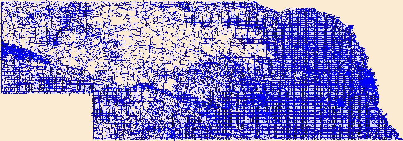
Layers of geospatial data include roads, airports, trails, and railroads.
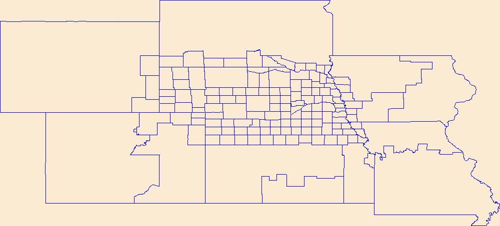
Geospatial data is comprised of government boundaries.

The Geographic Names Information System (GNIS) is the Federal standard for geographic nomenclature. The U.S. Geological Survey developed the GNIS for the U.S. Board on Geographic Names, a Federal inter-agency body chartered by public law to maintain uniform feature name usage throughout the Government and to promulgate standard names to the public. The GNIS is the official repository of domestic geographic names data; the official vehicle for geographic names use by all departments of the Federal Government; and the source for applying geographic names to Federal electronic and printed products of all types.
This data set contains imagery from the National Agriculture Imagery Program (NAIP). The NAIP program is administered by USDA FSA and has been established to support two main FSA strategic goals centered on agricultural production. These are, increase stewardship of America's natural resources while enhancing the environment, and to ensure commodities are procured and distributed effectively and efficiently to increase food security. The NAIP program supports these goals by acquiring and providing ortho imagery that has been collected during the agricultural growing season in the U.S. The NAIP ortho imagery is tailored to meet FSA requirements and is a fundamental tool used to support FSA farm and conservation programs....
|

|
