Filters: Tags: FWS (X)
52 results (21ms)|
Filters
Date Range
Extensions Types
Contacts
Categories Tag Types Tag Schemes
|

This map layer consists of federally owned or administered lands of the United States, Puerto Rico, and the U.S. Virgin Islands. For the most part, only areas of 320 acres or more are included; some smaller areas deemed to be important or significant are also included. There may be private inholdings within the boundaries of Federal lands in this map layer. Some established Federal lands which are larger than 320 acres are not included in this map layer, because their boundaries were not available from the owning or administering agency.
U.S. Fish and Wildlife Regional Boundaries
This is a web map service from the USFWS. It contains multiple layers related to final critical habitat for threatened and endangered species. Critical habitat are areas considered essential for the conservation of a listed species. These datasets include both line and polygon features.More information can be found here: http://criticalhabitat.fws.gov/crithab/

The intent of this data is to identify watersheds where Region 4 Fisheries Program work should be focused. Â Additional on-the-ground assessments may be necessary to verify conditions. Â The Fisheries Program proposes to work across Programs and with partners to identify conservation needs within the selected watersheds, and identify joint efforts and projects to leverage resources to maximize efficiency. These actions may include such projects as habitat improvements, barrier removal, propagation, and genetic conservation.

This map layer shows Indian lands of the United States. For the most part, only areas of 320 acres or more are included; some smaller areas deemed to be important or significant are also included. Federally-administered lands within a reservation are included for continuity; these may or may not be considered part of the reservation and are simply described with their feature type and the administrating Federal agency. Some established Indian lands which are larger than 320 acres are not included in this map layer because their boundaries were not available from the owning or administering agency.
The U. S. Fish and Wildlife Service (FWS) requests burn severity assessments through an agreement with the U.S. Geological Survey (USGS) to be completed by analysts with the Monitoring Trends in Burn Severity (MTBS) Program. These data products are burned area boundary shapefiles derived from post-fire sensor data (including Landsat TM, Landsat ETM+, Landsat OLI). The pre-fire and post-fire subsets included were used to create Normalized Burn Ratio (NBR) and then a differenced Normalized Burn Ratio (dNBR) image. The objective of this assessment was to generate burned area boundaries for each fire. Data bundles also include post-fire subset, pre-fire subset, NBR, and dNBR images. This map layer is a thematic raster...
This map contains a data layer that depicts the simplified boundaries of lands and waters administered by the U.S. Fish and Wildlife Service (USFWS) in North America, U.S. Trust Territories and Possessions. It includes only lands that are held by fee or secondary title by USFWS. The primary source for this information is the USFWS Realty program. For more information the NWRS visit: http://www.fws.gov/refuges/ This map contains a data layer that depicts the simplified boundaries of lands and waters administered by the U.S. Fish and Wildlife Service (USFWS) in North America, U.S. Trust Territories and Possessions. It includes only lands that are held by fee or secondary title by USFWS. The primary source...
Categories: Data;
Types: ArcGIS REST Map Service,
Map Service;
Tags: Boundaries,
FWS,
NWRS,
National Wildlife Refuge System
This data layer consists of National Wilderness Preservation System areas in the United States, Puerto Rico, and the U.S. Virgin Islands. The map layer was created by combining the best available data from the federal agency responsible for administration of a given wilderness area. Where larger scale data could not be obtained the National Atlas layer "National Wilderness Preservation System" was used as the data source. In its present form source data varies from a scale of 1:10000 to 1:2,000,000 (see lineage for details on source scale). Additional features have been added by the Environmental Science Division, Argonne National Laboratory based on their work with federal agencies; mainly BLM.
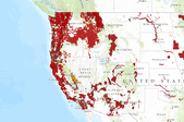
This product contains Bureau of Land Management (BLM) conservation efforts completed from 2009 - 2014 for the benefit of the Greater Sage-Grouse (GRSG).
This product contains Bureau of Land Management (BLM) conservation efforts completed from 2009 - 2014 for the benefit of the Greater Sage-Grouse (GRSG). The conservation efforts data included in this product are the state polygon data only.
The U. S. Fish and Wildlife Service (FWS) requests burn severity assessments through an agreement with the U.S. Geological Survey (USGS) to be completed by analysts with the Monitoring Trends in Burn Severity (MTBS) Program. These data products are burned area boundary shapefiles derived from post-fire sensor data (including Landsat TM, Landsat ETM+, Landsat OLI). The pre-fire and post-fire subsets included were used to create Normalized Burn Ratio (NBR) and then a differenced Normalized Burn Ratio (dNBR) image. The objective of this assessment was to generate burned area boundaries for each fire. Data bundles also include post-fire subset, pre-fire subset, NBR, and dNBR images. This map layer contains burned areas...
The U. S. Fish and Wildlife Service (FWS) requests burn severity assessments through an agreement with the U.S. Geological Survey (USGS) to be completed by analysts with the Monitoring Trends in Burn Severity (MTBS) Program. These data products are burned area boundary shapefiles derived from post-fire sensor data (including Landsat TM, Landsat ETM+, Landsat OLI). The pre-fire and post-fire subsets included were used to create Normalized Burn Ratio (NBR) and then a differenced Normalized Burn Ratio (dNBR) image. The objective of this assessment was to generate burned area boundaries for each fire. Data bundles also include post-fire subset, pre-fire subset, NBR, and dNBR images. This map layer is a thematic raster...
The U. S. Fish and Wildlife Service (FWS) requests burn severity assessments through an agreement with the U.S. Geological Survey (USGS) to be completed by analysts with the Monitoring Trends in Burn Severity (MTBS) Program. These data products are burned area boundary shapefiles derived from post-fire sensor data (including Landsat TM, Landsat ETM+, Landsat OLI). The pre-fire and post-fire subsets included were used to create Normalized Burn Ratio (NBR) and then a differenced Normalized Burn Ratio (dNBR) image. The objective of this assessment was to generate burned area boundaries for each fire. Data bundles also include post-fire subset, pre-fire subset, NBR, and dNBR images. This map layer is a thematic raster...
This product contains Bureau of Land Management (BLM) conservation efforts completed from 2009 - 2014 for the benefit of the Greater Sage-Grouse (GRSG).
The U. S. Fish and Wildlife Service (FWS) requests burn severity assessments through an agreement with the U.S. Geological Survey (USGS) to be completed by analysts with the Monitoring Trends in Burn Severity (MTBS) Program. These data products are burned area boundary shapefiles derived from post-fire sensor data (including Landsat TM, Landsat ETM+, Landsat OLI). The pre-fire and post-fire subsets included were used to create Normalized Burn Ratio (NBR) and then a differenced Normalized Burn Ratio (dNBR) image. The objective of this assessment was to generate burned area boundaries for each fire. Data bundles also include post fire subset, pre-fire subset, NBR, and dNBR images. This map layer is a vector Fire Occurrence...
Shows status of Southern Orange Subregion HCP Reserves
Categories: Data;
Types: ArcGIS REST Map Service,
ArcGIS Service Definition,
Downloadable,
Map Service;
Tags: FWS,
HCPS,
Orange County
Originally developed by the USGS National Atlas for the 2000 publication of the National Wild and Scenic River System (NWSRS). These Alaska data accompany the CONUS National Wild and Scenic River System data.
This data layer consists of National Wilderness Preservation System areas in the United States, Puerto Rico, and the U.S. Virgin Islands. The map layer was created by combining the best available data from the federal agency responsible for administration of a given wilderness area. Where larger scale data could not be obtained the National Atlas layer "National Wilderness Preservation System" was used as the data source. In its present form source data varies from a scale of 1:10000 to 1:2,000,000 (see lineage for details on source scale). Additional features have been added by the Environmental Science Division, Argonne National Laboratory based on their work with federal agencies; mainly BLM.
This data layer consists of National Wilderness Preservation System areas in the United States, Puerto Rico, and the U.S. Virgin Islands. The map layer was created by combining the best available data from the federal agency responsible for administration of a given wilderness area. Where larger scale data could not be obtained the National Atlas layer "National Wilderness Preservation System" was used as the data source. In its present form source data varies from a scale of 1:10000 to 1:2,000,000 (see lineage for details on source scale).
Merge of: - BLM Wilderness (GSSP, Ilana Cohen) - FS Wilderness (USFS, Tim Love) - NPS Wilderness (PAD-US) - FWS Wilderness (PAD-US)
Types: Downloadable;
Tags: Authorization,
BER,
BLM,
Baseline Environmental Report,
Bureau of Land Management,
|

|
