Filters: Tags: Federal (X) > partyWithName: U.S. Geological Survey (X)
10 results (75ms)|
Filters
Date Range
Extensions Types Contacts
Categories Tag Types
|

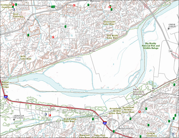
USGS developed The National Map (TNM) Gazetteer as the Federal and national standard (ANSI INCITS 446-2008) for geographic nomenclature based on the Geographic Names Information System (GNIS). The National Map Gazetteer contains information about physical and cultural geographic features, geographic areas, and locational entities that are generally recognizable and locatable by name (have achieved some landmark status) and are of interest to any level of government or to the public for any purpose that would lead to the representation of the feature in printed or electronic maps and/or geographic information systems. The dataset includes features of all types in the United States, its associated areas, and Antarctica,...
This project used species distribution modeling, population genetics, and geospatial analysis of historical vs. modern vertebrate populations to identify climate change refugia and population connectivity across the Sierra Nevada. It is hypothesized that climate change refugia will increase persistence and stability of populations and, as a result, maintain higher genetic diversity. This work helps managers assess the need to include connectivity and refugia in climate change adaptation strategies. Results help Sierra Nevada land managers allocate limited resources, aid future scenario assessment at landscape scales, and develop a performance measure for assessing resilience.
Categories: Data,
Project;
Tags: 2011,
2013,
CA,
California Landscape Conservation Cooperative,
Conservation Design,

The USGS Governmental Unit Boundaries service from The National Map (TNM) represents major civil areas for the Nation, including States or Territories, counties (or equivalents), Federal and Native American areas, congressional districts, minor civil divisions, incorporated places (such as cities and towns), and unincorporated places. Boundaries data are useful for understanding the extent of jurisdictional or administrative areas for a wide range of applications, including mapping or managing resources, and responding to natural disasters. Boundaries data also include extents of forest, grassland, park, wilderness, wildlife, and other reserve areas useful for recreational activities, such as hiking and backpacking....

The USGS Structures service from The National Map (TNM) consists of data to include the name, function, location, and other core information and characteristics of selected manmade facilities. The types of structures collected are largely determined by the needs of disaster planning and emergency response, and homeland security organizations. Structures data are designed to be used in general mapping and in the analysis of structure related activities using geographic information system technology. The National Map structures data is commonly combined with other data themes, such as boundaries, elevation, hydrography, and transportation, to produce general reference base maps. The National Map viewer allows free...
Categories: Data;
Types: ArcGIS REST Map Service,
Map Service;
Tags: NGP-TNM,
Overlay Map Service,
REST,
Structures,
US,

USGS developed The National Map (TNM) Gazetteer as the Federal and national standard (ANSI INCITS 446-2008) for geographic nomenclature based on the Geographic Names Information System (GNIS). The National Map Gazetteer contains information about physical and cultural geographic features, geographic areas, and locational entities that are generally recognizable and locatable by name (have achieved some landmark status) and are of interest to any level of government or to the public for any purpose that would lead to the representation of the feature in printed or electronic maps and/or geographic information systems. The dataset includes features of all types in the United States, its associated areas, and Antarctica,...
Categories: Data;
Types: ArcGIS REST Map Service,
Map Service,
OGC WFS Layer,
OGC WMS Layer;
Tags: BGN,
Cultural Resources,
GNIS,
Geographic Names,
NGP-TNM,

The USGS Governmental Unit Boundaries service from The National Map (TNM) represents major civil areas for the Nation, including States or Territories, counties (or equivalents), Federal and Native American areas, congressional districts, minor civil divisions, incorporated places (such as cities and towns), and unincorporated places. Boundaries data are useful for understanding the extent of jurisdictional or administrative areas for a wide range of applications, including mapping or managing resources, and responding to natural disasters. Boundaries data also include extents of forest, grassland, park, wilderness, wildlife, and other reserve areas useful for recreational activities, such as hiking and backpacking....
Categories: Data;
Types: ArcGIS REST Map Service,
Map Service;
Tags: Boundaries,
Governmental Units, and Administrative and Statistical Boundaries,
NGP-TNM,
Overlay Map Service,
REST,
This project developed a foundation for monitoring environmental change by identifying where and what to monitor in order to evaluate climate-change impacts. Phase 1 focused on landbirds, however a framework will be developed that recommends standardized monitoring for other taxa and environmental attributes. Phase II Deliverables produced as part of this proposed work include a Business Plan that 1) refines site selection by developing a decision model in combination with analyses of sites (or clusters of sites) arrayed by climate space, 2) works with the LCC science committee, Joint Ventures, and other partners to choose a manageable number of core monitoring variables, 3) develops and/or adopting existing protocols...
To be successful, natural resource managers need to synthesize diverse information on the effects of management actions, climate change and other stressors on wildlife populations at appropriate scales. The project team developed a Decision Support Tool (DST) that integrates the results of multi-disciplinary, multi-taxa modeling allowing users to project outcomes of conservation actions, accounting for effects of climate change and other stressors. This DST builds on work to improve a sea level rise tool for adaptive tidal wetland restoration and management. The DST provides information on how restoration can increase population resilience and long-term persistence at multiple scales for multiple species throughout...
Categories: Data,
Project;
Tags: 2012,
Applications and Tools,
CA,
California Landscape Conservation Cooperative,
Conservation NGOs,
|

|