Filters: Tags: Forest Type Group (X)
8 results (7ms)|
Filters
|
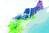
This dataset portrays 28 forest type groups across the contiguous United States. These data were derived from MODIS composite images from the 2002 and 2003 growing seasons in combination with nearly 100 other geospatial data layers, including elevation, slope, aspect, ecoregions, and PRISM climate data. The dataset was developed as a collaborative effort between the USFS Forest Inventory and Analysis and Forest Health Monitoring programs and the USFS Remote Sensing Applications Center.

This dataset portrays 28 forest type groups across the contiguous United States. These data were derived from MODIS composite images from the 2002 and 2003 growing seasons in combination with nearly 100 other geospatial data layers, including elevation, slope, aspect, ecoregions, and PRISM climate data. The dataset was developed as a collaborative effort between the USFS Forest Inventory and Analysis and Forest Health Monitoring programs and the USFS Remote Sensing Applications Center.
This dataset portrays 28 forest type groups across the contiguous United States. These data were derived from MODIS composite images from the 2002 and 2003 growing seasons in combination with nearly 100 other geospatial data layers, including elevation, slope, aspect, ecoregions, and PRISM climate data. The dataset was developed as a collaborative effort between the USFS Forest Inventory and Analysis and Forest Health Monitoring programs and the USFS Remote Sensing Applications Center.

This dataset portrays 28 forest type groups across the contiguous United States. These data were derived from MODIS composite images from the 2002 and 2003 growing seasons in combination with nearly 100 other geospatial data layers, including elevation, slope, aspect, ecoregions, and PRISM climate data. The dataset was developed as a collaborative effort between the USFS Forest Inventory and Analysis and Forest Health Monitoring programs and the USFS Remote Sensing Applications Center.

This dataset portrays 28 forest type groups across the contiguous United States. These data were derived from MODIS composite images from the 2002 and 2003 growing seasons in combination with nearly 100 other geospatial data layers, including elevation, slope, aspect, ecoregions, and PRISM climate data. The dataset was developed as a collaborative effort between the USFS Forest Inventory and Analysis and Forest Health Monitoring programs and the USFS Remote Sensing Applications Center.

This dataset portrays 28 forest type groups across the contiguous United States. These data were derived from MODIS composite images from the 2002 and 2003 growing seasons in combination with nearly 100 other geospatial data layers, including elevation, slope, aspect, ecoregions, and PRISM climate data. The dataset was developed as a collaborative effort between the USFS Forest Inventory and Analysis and Forest Health Monitoring programs and the USFS Remote Sensing Applications Center.

This dataset portrays 28 forest type groups across the contiguous United States. These data were derived from MODIS composite images from the 2002 and 2003 growing seasons in combination with nearly 100 other geospatial data layers, including elevation, slope, aspect, ecoregions, and PRISM climate data. The dataset was developed as a collaborative effort between the USFS Forest Inventory and Analysis and Forest Health Monitoring programs and the USFS Remote Sensing Applications Center.

This dataset portrays 28 forest type groups across Alaska. These data were derived from MODIS composite images from the 2002 and 2003 growing seasons in combination with nearly 100 other geospatial data layers, including elevation, slope, aspect, and ecoregions. The dataset was developed as a collaborative effort between the USFS Forest Inventory and Analysis and Forest Health Monitoring programs and the USFS Remote Sensing Applications Center.
|

|
