Filters: Tags: GENMOM (X)
36 results (57ms)|
Filters
|

Simulated Surface Runoff by the biogeography model MAPSS using S. Hostetler's (USGS) climate data (detailed information available at http://regclim.coas.oregonstate.edu/domains.html), created using RegCM3 with GENMOM boundary conditions. MAPSS (Mapped Atmosphere-Plant-Soil System) is a static biogeography model that projects potential vegetation distribution and hydrological flows on a grid (http://www.databasin.org/climate-center/features/mapss-model). MAPSS has been used widely for various climate change assessments including the 2000 National Assessment Synthesis Team's report. MAPSS uses long term, average monthly climate data (mean monthly temperature, vapor pressure, wind speed, and precipitation) as well...

This dataset depicts the Difference for Summer Precipitation for 2015-2030 and 2045-2060 compared to 1968-1999 for GENMOM. These data have been generated using a regional climate model called RegCM3 using boundary conditions from observations or general circulation models for historical conditions, and from GCM projections for future conditions. Regional climate model description: RegCM3 is the third generation of the Regional Climate Model originally developed at the National Center for Atmospheric Research during the late 1980s and early 1990s. Details on current model components and applications of the model can be found in numerous publications (e.g., Giorgi et al, 2004a,b, Pal et al, 2007), the ICTP RegCNET...

This dataset corresponds to statistically downscaled and reprojected GCM-driven RegCM3 (regional climate model) future projections. Data were bias corrected using the delta/anomaly method whereby the difference between future and historical projections from RegCM3 were calculated, reprojected and downscaled using linear interpolation to then modify a PRISM model generated historical baseline (1968-1999).

This dataset depicts the Difference of Summer Precipitation for 2045-2060 compared to 1968-1999 for GFDL. These data have been generated using a regional climate model called RegCM3 using boundary conditions from observations or general circulation models for historical conditions, and from GCM projections for future conditions. Regional climate model description: RegCM3 is the third generation of the Regional Climate Model originally developed at the National Center for Atmospheric Research during the late 1980s and early 1990s. Details on current model components and applications of the model can be found in numerous publications (e.g., Giorgi et al, 2004a,b, Pal et al, 2007), the ICTP RegCNET web site (http://users.ictp.it/RegCNET/model.html),...

Simulated Potential Natural Vegetation Class by the biogeography model MAPSS using S. Hostetler's (USGS) climate data (detailed information available at http://regclim.coas.oregonstate.edu/domains.html), created using RegCM3 with GENMOM boundary conditions. MAPSS (Mapped Atmosphere-Plant-Soil System) is a static biogeography model that projects potential vegetation distribution and hydrological flows on a grid (http://www.databasin.org/climate-center/features/mapss-model). MAPSS has been used widely for various climate change assessments including the 2000 National Assessment Synthesis Team's report. MAPSS uses long term, average monthly climate data (mean monthly temperature, vapor pressure, wind speed, and precipitation)...

These data represent GCM-driven RegCM3 future projections.

These data represent GCM-driven RegCM3 future projections.

Climate data (NCEP: Average Annual Temperature, 1968-1999) have been generated using a regional climate model called RegCM3 using boundary conditions from observations or general circulation models for historical conditions, and from GCM projections for future conditions. Regional climate model description: RegCM3 is the third generation of the Regional Climate Model originally developed at the National Center for Atmospheric Research during the late 1980s and early 1990s. Details on current model components and applications of the model can be found in numerous publications (e.g., Giorgi et al, 2004a,b, Pal et al, 2007), the ICTP RegCNET web site (http://users.ictp.it/RegCNET/model.html), and the ICTP RegCM publications...
Simulated Surface Runoff by the biogeography model MAPSS using S. Hostetler's (USGS) climate data (detailed information available at http://regclim.coas.oregonstate.edu/domains.html), created using RegCM3 with GENMOM boundary conditions. MAPSS (Mapped Atmosphere-Plant-Soil System) is a static biogeography model that projects potential vegetation distribution and hydrological flows on a grid (http://www.databasin.org/climate-center/features/mapss-model). MAPSS has been used widely for various climate change assessments including the 2000 National Assessment Synthesis Team's report. MAPSS uses long term, average monthly climate data (mean monthly temperature, vapor pressure, wind speed, and precipitation) as well...
This dataset depicts the Difference for Total Average Annual Precipitation for 2015-2030 and 2045-2060 compared to 1968-1999 for GENMOM. These data have been generated using a regional climate model called RegCM3 using boundary conditions from observations or general circulation models for historical conditions, and from GCM projections for future conditions. Regional climate model description: RegCM3 is the third generation of the Regional Climate Model originally developed at the National Center for Atmospheric Research during the late 1980s and early 1990s. Details on current model components and applications of the model can be found in numerous publications (e.g., Giorgi et al, 2004a,b, Pal et al, 2007),...

Simulated Surface Runoff Change by the biogeography model MAPSS using S. Hostetler's (USGS) climate data (detailed information available at http://regclim.coas.oregonstate.edu/domains.html), created using RegCM3 with GENMOM boundary conditions. MAPSS (Mapped Atmosphere-Plant-Soil System) is a static biogeography model that projects potential vegetation distribution and hydrological flows on a grid (http://www.databasin.org/climate-center/features/mapss-model). MAPSS has been used widely for various climate change assessments including the 2000 National Assessment Synthesis Team's report. MAPSS uses long term, average monthly climate data (mean monthly temperature, vapor pressure, wind speed, and precipitation)...

This dataset depicts the Difference for Average Summer Temperature for Jul-Sep for 2015-2030 and 2045-2060 compared to 1968-1999 for GENMOM. These data have been generated using a regional climate model called RegCM3 using boundary conditions from observations or general circulation models for historical conditions, and from GCM projections for future conditions. Regional climate model description: RegCM3 is the third generation of the Regional Climate Model originally developed at the National Center for Atmospheric Research during the late 1980s and early 1990s. Details on current model components and applications of the model can be found in numerous publications (e.g., Giorgi et al, 2004a,b, Pal et al, 2007),...
This dataset depicts the Difference of Winter Precipitation for 2045-2060 compared to 1968-1999 for GFDL. These data have been generated using a regional climate model called RegCM3 using boundary conditions from observations or general circulation models for historical conditions, and from GCM projections for future conditions. Regional climate model description: RegCM3 is the third generation of the Regional Climate Model originally developed at the National Center for Atmospheric Research during the late 1980s and early 1990s. Details on current model components and applications of the model can be found in numerous publications (e.g., Giorgi et al, 2004a,b, Pal et al, 2007), the ICTP RegCNET web site (http://users.ictp.it/RegCNET/model.html),...

This dataset depicts areas of major vegetation change between the future potential natural vegetation class for this year and GCM compared to potential natural vegetation class for the historical period simulated using MAPSS with PRISM climate data. Areas are labeled by the future potential natural vegetation class. Simulated Potential Natural Vegetation Class Change by the biogeography model MAPSS using S. Hostetler's (USGS) climate data (detailed information available at http://regclim.coas.oregonstate.edu/domains.html), created using RegCM3 with GENMOM boundary conditions. MAPSS (Mapped Atmosphere-Plant-Soil System) is a static biogeography model that projects potential vegetation distribution and hydrological...

This dataset depicts the Difference of Winter Precipitation for 2045-2060 compared to 1968-1999 for GFDL. These data have been generated using a regional climate model called RegCM3 using boundary conditions from observations or general circulation models for historical conditions, and from GCM projections for future conditions. Regional climate model description: RegCM3 is the third generation of the Regional Climate Model originally developed at the National Center for Atmospheric Research during the late 1980s and early 1990s. Details on current model components and applications of the model can be found in numerous publications (e.g., Giorgi et al, 2004a,b, Pal et al, 2007), the ICTP RegCNET web site (http://users.ictp.it/RegCNET/model.html),...

This dataset depicts the Difference of Average Annual Average Precipitation for 2045-2060 compared to 1968-1999 for GFDL. These data have been generated using a regional climate model called RegCM3 using boundary conditions from observations or general circulation models for historical conditions, and from GCM projections for future conditions. Regional climate model description: RegCM3 is the third generation of the Regional Climate Model originally developed at the National Center for Atmospheric Research during the late 1980s and early 1990s. Details on current model components and applications of the model can be found in numerous publications (e.g., Giorgi et al, 2004a,b, Pal et al, 2007), the ICTP RegCNET...
Climate data (GENMOM: Average Annual Total Precipitation, 2045-2060) have been generated using a regional climate model called RegCM3 using boundary conditions from observations or general circulation models for historical conditions, and from GCM projections for future conditions. Regional climate model description: RegCM3 is the third generation of the Regional Climate Model originally developed at the National Center for Atmospheric Research during the late 1980s and early 1990s. Details on current model components and applications of the model can be found in numerous publications (e.g., Giorgi et al, 2004a,b, Pal et al, 2007), the ICTP RegCNET web site (http://users.ictp.it/RegCNET/model.html), and the ICTP...
This dataset represents PRISM historical data (1968-1999) and de-biased GCM-driven RegCM3 future projections. Data were de-biased using calculated anomalies on top of PRISM data. Climate data (ECHAM5: Average Annual Total Precipitation, 2045-2060) have been generated using a regional climate model called RegCM3 using boundary conditions from observations or general circulation models for historical conditions, and from GCM projections for future conditions. Regional climate model description: RegCM3 is the third generation of the Regional Climate Model originally developed at the National Center for Atmospheric Research during the late 1980s and early 1990s. Details on current model components and applications...
Simulated Surface Runoff Change by the biogeography model MAPSS using S. Hostetler's (USGS) climate data (detailed information available at http://regclim.coas.oregonstate.edu/domains.html), created using RegCM3 with GENMOM boundary conditions. MAPSS (Mapped Atmosphere-Plant-Soil System) is a static biogeography model that projects potential vegetation distribution and hydrological flows on a grid (http://www.databasin.org/climate-center/features/mapss-model). MAPSS has been used widely for various climate change assessments including the 2000 National Assessment Synthesis Team's report. MAPSS uses long term, average monthly climate data (mean monthly temperature, vapor pressure, wind speed, and precipitation)...
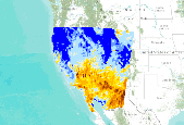
This dataset depicts the Difference for Total Average Annual Precipitation for 2015-2030 and 2045-2060 compared to 1968-1999 for GENMOM. These data have been generated using a regional climate model called RegCM3 using boundary conditions from observations or general circulation models for historical conditions, and from GCM projections for future conditions. Regional climate model description: RegCM3 is the third generation of the Regional Climate Model originally developed at the National Center for Atmospheric Research during the late 1980s and early 1990s. Details on current model components and applications of the model can be found in numerous publications (e.g., Giorgi et al, 2004a,b, Pal et al, 2007),...
|

|
