Filters
Date Types (for Date Range)
Contacts
(Less)
Tag Types
Tag Schemes
|

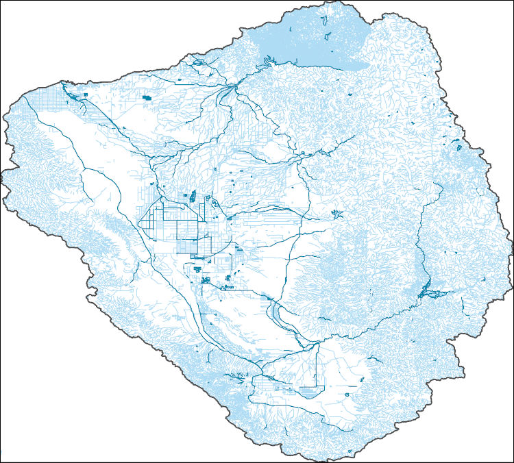
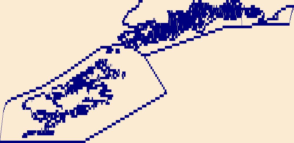
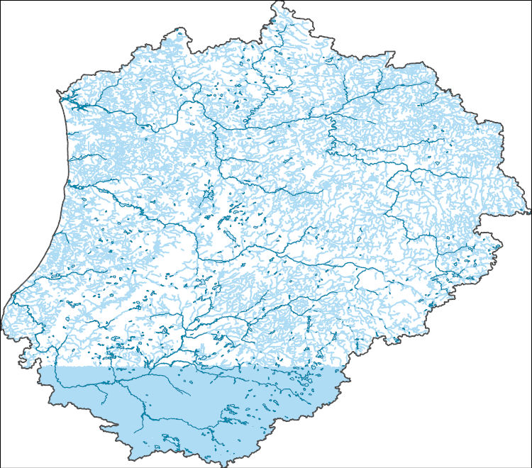
The High Resolution National Hydrography Dataset Plus (NHDPlus HR) is an integrated set of geospatial data layers, including the best available National Hydrography Dataset (NHD), the 10-meter 3D Elevation Program Digital Elevation Model (3DEP DEM), and the National Watershed Boundary Dataset (WBD). The NHDPlus HR combines the NHD, 3DEP DEMs, and WBD to create a stream network with linear referencing, feature naming, "value added attributes" (VAAs), elevation-derived catchments, and other features for hydrologic data analysis. The stream network with linear referencing is a system of data relationships applied to hydrographic systems so that one stream reach "flows" into another and "events" can be tied to and traced...
Tags: AK,
Alaska,
Downloadable Data,
FileGDB,
FileGDB 10.1, All tags...
HU-8 Subbasin,
HU-8 Subbasin,
HU8_19020602,
Hydrography,
Kenai Peninsula County,
Kodiak Island County,
Lake and Peninsula County,
NHDPlus HR Rasters,
NHDPlus High Resolution (NHDPlus HR),
National Hydrography Dataset (NHD),
National Hydrography Dataset Plus High Resolution (NHDPlus HR),
National Hydrography Dataset Plus High Resolution (NHDPlus HR) Current,
US,
United States,
base maps,
cartography,
catchments,
channels,
digital elevation models,
drainage basins,
earth sciences,
elevation,
environment,
geographic information systems,
geoscientific,
geospatial analysis,
hydrographic datasets,
hydrographic features,
hydrology,
imagery,
inland waters,
lakes,
land surface characteristics,
reservoirs,
river reaches,
rivers,
streamflow,
streamflow data,
streams,
topography,
water bodies,
water quality,
water resources,
watersheds, Fewer tags

The High Resolution National Hydrography Dataset Plus (NHDPlus HR) is an integrated set of geospatial data layers, including the best available National Hydrography Dataset (NHD), the 10-meter 3D Elevation Program Digital Elevation Model (3DEP DEM), and the National Watershed Boundary Dataset (WBD). The NHDPlus HR combines the NHD, 3DEP DEMs, and WBD to create a stream network with linear referencing, feature naming, "value added attributes" (VAAs), elevation-derived catchments, and other features for hydrologic data analysis. The stream network with linear referencing is a system of data relationships applied to hydrographic systems so that one stream reach "flows" into another and "events" can be tied to and traced...
Tags: AR,
Arkansas,
Arkansas County,
Bolivar County,
Bollinger County, All tags...
Butler County,
Cape Girardeau County,
Clay County,
Coahoma County,
Craighead County,
Crittenden County,
Cross County,
DeSoto County,
Desha County,
Downloadable Data,
Dunklin County,
Faulkner County,
FileGDB,
FileGDB 10.1,
Greene County,
HU-4 Subregion,
HU-4 Subregion,
HU4_0802,
Hydrography,
Iron County,
Jackson County,
Jefferson County,
Lawrence County,
Lee County,
Lincoln County,
Lonoke County,
MO,
MS,
Madison County,
Mississippi,
Mississippi County,
Missouri,
Monroe County,
NHDPlus HR Rasters,
NHDPlus High Resolution (NHDPlus HR),
National Hydrography Dataset (NHD),
National Hydrography Dataset Plus High Resolution (NHDPlus HR),
National Hydrography Dataset Plus High Resolution (NHDPlus HR) Current,
New Madrid County,
Pemiscot County,
Phillips County,
Poinsett County,
Prairie County,
Pulaski County,
Randolph County,
Reynolds County,
Scott County,
St. Francis County,
St. Francois County,
Ste. Genevieve County,
Stoddard County,
Tunica County,
US,
United States,
Washington County,
Wayne County,
White County,
Woodruff County,
base maps,
cartography,
catchments,
channels,
digital elevation models,
drainage basins,
earth sciences,
elevation,
environment,
geographic information systems,
geoscientific,
geospatial analysis,
hydrographic datasets,
hydrographic features,
hydrology,
imagery,
inland waters,
lakes,
land surface characteristics,
reservoirs,
river reaches,
rivers,
streamflow,
streamflow data,
streams,
topography,
water bodies,
water quality,
water resources,
watersheds, Fewer tags

The High Resolution National Hydrography Dataset Plus (NHDPlus HR) is an integrated set of geospatial data layers, including the best available National Hydrography Dataset (NHD), the 10-meter 3D Elevation Program Digital Elevation Model (3DEP DEM), and the National Watershed Boundary Dataset (WBD). The NHDPlus HR combines the NHD, 3DEP DEMs, and WBD to create a stream network with linear referencing, feature naming, "value added attributes" (VAAs), elevation-derived catchments, and other features for hydrologic data analysis. The stream network with linear referencing is a system of data relationships applied to hydrographic systems so that one stream reach "flows" into another and "events" can be tied to and traced...
Tags: Aitkin County,
Ashland County,
Bayfield County,
Carlton County,
Cook County, All tags...
Douglas County,
Downloadable Data,
FileGDB,
FileGDB 10.1,
Gogebic County,
HU-4 Subregion,
HU-4 Subregion,
HU4_0401,
Hydrography,
Iron County,
Itasca County,
Lake County,
MI,
MN,
Michigan,
Minnesota,
NHDPlus HR Rasters,
NHDPlus High Resolution (NHDPlus HR),
National Hydrography Dataset (NHD),
National Hydrography Dataset Plus High Resolution (NHDPlus HR),
National Hydrography Dataset Plus High Resolution (NHDPlus HR) Current,
Pine County,
St. Louis County,
US,
United States,
WI,
Wisconsin,
base maps,
cartography,
catchments,
channels,
digital elevation models,
drainage basins,
earth sciences,
elevation,
environment,
geographic information systems,
geoscientific,
geospatial analysis,
hydrographic datasets,
hydrographic features,
hydrology,
imagery,
inland waters,
lakes,
land surface characteristics,
reservoirs,
river reaches,
rivers,
streamflow,
streamflow data,
streams,
topography,
water bodies,
water quality,
water resources,
watersheds, Fewer tags

The High Resolution National Hydrography Dataset Plus (NHDPlus HR) is an integrated set of geospatial data layers, including the best available National Hydrography Dataset (NHD), the 10-meter 3D Elevation Program Digital Elevation Model (3DEP DEM), and the National Watershed Boundary Dataset (WBD). The NHDPlus HR combines the NHD, 3DEP DEMs, and WBD to create a stream network with linear referencing, feature naming, "value added attributes" (VAAs), elevation-derived catchments, and other features for hydrologic data analysis. The stream network with linear referencing is a system of data relationships applied to hydrographic systems so that one stream reach "flows" into another and "events" can be tied to and traced...
Tags: Berrien County,
Cook County,
Dodge County,
Downloadable Data,
FileGDB, All tags...
FileGDB 10.1,
Fond du Lac County,
HU-4 Subregion,
HU-4 Subregion,
HU4_0404,
Hydrography,
IL,
IN,
Illinois,
Indiana,
Kenosha County,
LaPorte County,
Lake County,
Lake County,
MI,
Michigan,
Milwaukee County,
NHDPlus HR Rasters,
NHDPlus High Resolution (NHDPlus HR),
National Hydrography Dataset (NHD),
National Hydrography Dataset Plus High Resolution (NHDPlus HR),
National Hydrography Dataset Plus High Resolution (NHDPlus HR) Current,
Ozaukee County,
Porter County,
Racine County,
Sheboygan County,
St. Joseph County,
US,
United States,
WI,
Washington County,
Waukesha County,
Wisconsin,
base maps,
cartography,
catchments,
channels,
digital elevation models,
drainage basins,
earth sciences,
elevation,
environment,
geographic information systems,
geoscientific,
geospatial analysis,
hydrographic datasets,
hydrographic features,
hydrology,
imagery,
inland waters,
lakes,
land surface characteristics,
reservoirs,
river reaches,
rivers,
streamflow,
streamflow data,
streams,
topography,
water bodies,
water quality,
water resources,
watersheds, Fewer tags

The High Resolution National Hydrography Dataset Plus (NHDPlus HR) is an integrated set of geospatial data layers, including the best available National Hydrography Dataset (NHD), the 10-meter 3D Elevation Program Digital Elevation Model (3DEP DEM), and the National Watershed Boundary Dataset (WBD). The NHDPlus HR combines the NHD, 3DEP DEMs, and WBD to create a stream network with linear referencing, feature naming, "value added attributes" (VAAs), elevation-derived catchments, and other features for hydrologic data analysis. The stream network with linear referencing is a system of data relationships applied to hydrographic systems so that one stream reach "flows" into another and "events" can be tied to and traced...
Tags: Adams County,
Amite County,
Attala County,
Carroll County,
Choctaw County, All tags...
Claiborne County,
Concordia County,
Copiah County,
Downloadable Data,
FileGDB,
FileGDB 10.1,
Franklin County,
HU-4 Subregion,
HU-4 Subregion,
HU4_0806,
Hinds County,
Holmes County,
Hydrography,
Jefferson County,
LA,
Leake County,
Lincoln County,
Louisiana,
MS,
Madison County,
Madison County,
Mississippi,
Montgomery County,
NHDPlus HR Rasters,
NHDPlus High Resolution (NHDPlus HR),
National Hydrography Dataset (NHD),
National Hydrography Dataset Plus High Resolution (NHDPlus HR),
National Hydrography Dataset Plus High Resolution (NHDPlus HR) Current,
Oktibbeha County,
Tensas County,
US,
United States,
Warren County,
Webster County,
West Feliciana County,
Wilkinson County,
Yazoo County,
base maps,
cartography,
catchments,
channels,
digital elevation models,
drainage basins,
earth sciences,
elevation,
environment,
geographic information systems,
geoscientific,
geospatial analysis,
hydrographic datasets,
hydrographic features,
hydrology,
imagery,
inland waters,
lakes,
land surface characteristics,
reservoirs,
river reaches,
rivers,
streamflow,
streamflow data,
streams,
topography,
water bodies,
water quality,
water resources,
watersheds, Fewer tags

The High Resolution National Hydrography Dataset Plus (NHDPlus HR) is an integrated set of geospatial data layers, including the best available National Hydrography Dataset (NHD), the 10-meter 3D Elevation Program Digital Elevation Model (3DEP DEM), and the National Watershed Boundary Dataset (WBD). The NHDPlus HR combines the NHD, 3DEP DEMs, and WBD to create a stream network with linear referencing, feature naming, "value added attributes" (VAAs), elevation-derived catchments, and other features for hydrologic data analysis. The stream network with linear referencing is a system of data relationships applied to hydrographic systems so that one stream reach "flows" into another and "events" can be tied to and traced...
Tags: Attala County,
Choctaw County,
Copiah County,
Downloadable Data,
FileGDB, All tags...
FileGDB 10.1,
HU-4 Subregion,
HU-4 Subregion,
HU4_0318,
Hancock County,
Hinds County,
Hydrography,
Jefferson Davis County,
Kemper County,
LA,
Lamar County,
Lawrence County,
Leake County,
Lincoln County,
Louisiana,
MS,
Madison County,
Marion County,
Mississippi,
NHDPlus HR Rasters,
NHDPlus High Resolution (NHDPlus HR),
National Hydrography Dataset (NHD),
National Hydrography Dataset Plus High Resolution (NHDPlus HR),
National Hydrography Dataset Plus High Resolution (NHDPlus HR) Current,
Neshoba County,
Newton County,
Noxubee County,
Pearl River County,
Pike County,
Rankin County,
Scott County,
Simpson County,
Smith County,
St. Tammany County,
Tangipahoa County,
US,
United States,
Walthall County,
Washington County,
Winston County,
base maps,
cartography,
catchments,
channels,
digital elevation models,
drainage basins,
earth sciences,
elevation,
environment,
geographic information systems,
geoscientific,
geospatial analysis,
hydrographic datasets,
hydrographic features,
hydrology,
imagery,
inland waters,
lakes,
land surface characteristics,
reservoirs,
river reaches,
rivers,
streamflow,
streamflow data,
streams,
topography,
water bodies,
water quality,
water resources,
watersheds, Fewer tags

The High Resolution National Hydrography Dataset Plus (NHDPlus HR) is an integrated set of geospatial data layers, including the best available National Hydrography Dataset (NHD), the 10-meter 3D Elevation Program Digital Elevation Model (3DEP DEM), and the National Watershed Boundary Dataset (WBD). The NHDPlus HR combines the NHD, 3DEP DEMs, and WBD to create a stream network with linear referencing, feature naming, "value added attributes" (VAAs), elevation-derived catchments, and other features for hydrologic data analysis. The stream network with linear referencing is a system of data relationships applied to hydrographic systems so that one stream reach "flows" into another and "events" can be tied to and traced...
Tags: Antrim County,
Benzie County,
Charlevoix County,
Cheboygan County,
Clare County, All tags...
Crawford County,
Downloadable Data,
Emmet County,
FileGDB,
FileGDB 10.1,
Grand Traverse County,
HU-4 Subregion,
HU-4 Subregion,
HU4_0406,
Hydrography,
Kalkaska County,
Lake County,
Leelanau County,
MI,
Manistee County,
Mason County,
Mecosta County,
Michigan,
Missaukee County,
Montcalm County,
Muskegon County,
NHDPlus HR Rasters,
NHDPlus High Resolution (NHDPlus HR),
National Hydrography Dataset (NHD),
National Hydrography Dataset Plus High Resolution (NHDPlus HR),
National Hydrography Dataset Plus High Resolution (NHDPlus HR) Current,
Newaygo County,
Oceana County,
Osceola County,
Otsego County,
Ottawa County,
Roscommon County,
US,
United States,
Wexford County,
base maps,
cartography,
catchments,
channels,
digital elevation models,
drainage basins,
earth sciences,
elevation,
environment,
geographic information systems,
geoscientific,
geospatial analysis,
hydrographic datasets,
hydrographic features,
hydrology,
imagery,
inland waters,
lakes,
land surface characteristics,
reservoirs,
river reaches,
rivers,
streamflow,
streamflow data,
streams,
topography,
water bodies,
water quality,
water resources,
watersheds, Fewer tags

The High Resolution National Hydrography Dataset Plus (NHDPlus HR) is an integrated set of geospatial data layers, including the best available National Hydrography Dataset (NHD), the 10-meter 3D Elevation Program Digital Elevation Model (3DEP DEM), and the National Watershed Boundary Dataset (WBD). The NHDPlus HR combines the NHD, 3DEP DEMs, and WBD to create a stream network with linear referencing, feature naming, "value added attributes" (VAAs), elevation-derived catchments, and other features for hydrologic data analysis. The stream network with linear referencing is a system of data relationships applied to hydrographic systems so that one stream reach "flows" into another and "events" can be tied to and traced...
Tags: Alger County,
Baraga County,
Chippewa County,
Downloadable Data,
FileGDB, All tags...
FileGDB 10.1,
Gogebic County,
HU-4 Subregion,
HU-4 Subregion,
HU4_0402,
Houghton County,
Hydrography,
Iron County,
Iron County,
Keweenaw County,
Luce County,
MI,
Mackinac County,
Marquette County,
Michigan,
NHDPlus HR Rasters,
NHDPlus High Resolution (NHDPlus HR),
National Hydrography Dataset (NHD),
National Hydrography Dataset Plus High Resolution (NHDPlus HR),
National Hydrography Dataset Plus High Resolution (NHDPlus HR) Current,
Ontonagon County,
Schoolcraft County,
US,
United States,
Vilas County,
WI,
Wisconsin,
base maps,
cartography,
catchments,
channels,
digital elevation models,
drainage basins,
earth sciences,
elevation,
environment,
geographic information systems,
geoscientific,
geospatial analysis,
hydrographic datasets,
hydrographic features,
hydrology,
imagery,
inland waters,
lakes,
land surface characteristics,
reservoirs,
river reaches,
rivers,
streamflow,
streamflow data,
streams,
topography,
water bodies,
water quality,
water resources,
watersheds, Fewer tags

The High Resolution National Hydrography Dataset Plus (NHDPlus HR) is an integrated set of geospatial data layers, including the best available National Hydrography Dataset (NHD), the 10-meter 3D Elevation Program Digital Elevation Model (3DEP DEM), and the National Watershed Boundary Dataset (WBD). The NHDPlus HR combines the NHD, 3DEP DEMs, and WBD to create a stream network with linear referencing, feature naming, "value added attributes" (VAAs), elevation-derived catchments, and other features for hydrologic data analysis. The stream network with linear referencing is a system of data relationships applied to hydrographic systems so that one stream reach "flows" into another and "events" can be tied to and traced...
Tags: Adams County,
Alger County,
Baraga County,
Brown County,
Calumet County, All tags...
Columbia County,
Delta County,
Dickinson County,
Dodge County,
Door County,
Downloadable Data,
FileGDB,
FileGDB 10.1,
Florence County,
Fond du Lac County,
Forest County,
Gogebic County,
Green Lake County,
HU-4 Subregion,
HU-4 Subregion,
HU4_0403,
Hydrography,
Iron County,
Kewaunee County,
Langlade County,
Luce County,
MI,
Mackinac County,
Manitowoc County,
Marathon County,
Marinette County,
Marquette County,
Marquette County,
Menominee County,
Menominee County,
Michigan,
NHDPlus HR Rasters,
NHDPlus High Resolution (NHDPlus HR),
National Hydrography Dataset (NHD),
National Hydrography Dataset Plus High Resolution (NHDPlus HR),
National Hydrography Dataset Plus High Resolution (NHDPlus HR) Current,
Oconto County,
Oneida County,
Outagamie County,
Ozaukee County,
Portage County,
Schoolcraft County,
Shawano County,
Sheboygan County,
US,
United States,
Vilas County,
WI,
Waupaca County,
Waushara County,
Winnebago County,
Wisconsin,
base maps,
cartography,
catchments,
channels,
digital elevation models,
drainage basins,
earth sciences,
elevation,
environment,
geographic information systems,
geoscientific,
geospatial analysis,
hydrographic datasets,
hydrographic features,
hydrology,
imagery,
inland waters,
lakes,
land surface characteristics,
reservoirs,
river reaches,
rivers,
streamflow,
streamflow data,
streams,
topography,
water bodies,
water quality,
water resources,
watersheds, Fewer tags

The High Resolution National Hydrography Dataset Plus (NHDPlus HR) is an integrated set of geospatial data layers, including the best available National Hydrography Dataset (NHD), the 10-meter 3D Elevation Program Digital Elevation Model (3DEP DEM), and the National Watershed Boundary Dataset (WBD). The NHDPlus HR combines the NHD, 3DEP DEMs, and WBD to create a stream network with linear referencing, feature naming, "value added attributes" (VAAs), elevation-derived catchments, and other features for hydrologic data analysis. The stream network with linear referencing is a system of data relationships applied to hydrographic systems so that one stream reach "flows" into another and "events" can be tied to and traced...
Tags: AR,
Arkansas,
Benton County,
Bolivar County,
Calhoun County, All tags...
Carroll County,
Chickasaw County,
Chicot County,
Coahoma County,
DeSoto County,
Desha County,
Downloadable Data,
East Carroll County,
FileGDB,
FileGDB 10.1,
Grenada County,
HU-4 Subregion,
HU-4 Subregion,
HU4_0803,
Holmes County,
Humphreys County,
Hydrography,
Issaquena County,
LA,
Lafayette County,
Leflore County,
Louisiana,
MS,
Madison County,
Marshall County,
Mississippi,
Montgomery County,
NHDPlus HR Rasters,
NHDPlus High Resolution (NHDPlus HR),
National Hydrography Dataset (NHD),
National Hydrography Dataset Plus High Resolution (NHDPlus HR),
National Hydrography Dataset Plus High Resolution (NHDPlus HR) Current,
Panola County,
Pontotoc County,
Quitman County,
Sharkey County,
Shelby County,
Sunflower County,
TN,
Tallahatchie County,
Tate County,
Tennessee,
Tippah County,
Tunica County,
US,
Union County,
United States,
Warren County,
Washington County,
Webster County,
Yalobusha County,
Yazoo County,
base maps,
cartography,
catchments,
channels,
digital elevation models,
drainage basins,
earth sciences,
elevation,
environment,
geographic information systems,
geoscientific,
geospatial analysis,
hydrographic datasets,
hydrographic features,
hydrology,
imagery,
inland waters,
lakes,
land surface characteristics,
reservoirs,
river reaches,
rivers,
streamflow,
streamflow data,
streams,
topography,
water bodies,
water quality,
water resources,
watersheds, Fewer tags

The High Resolution National Hydrography Dataset Plus (NHDPlus HR) is an integrated set of geospatial data layers, including the best available National Hydrography Dataset (NHD), the 10-meter 3D Elevation Program Digital Elevation Model (3DEP DEM), and the National Watershed Boundary Dataset (WBD). The NHDPlus HR combines the NHD, 3DEP DEMs, and WBD to create a stream network with linear referencing, feature naming, "value added attributes" (VAAs), elevation-derived catchments, and other features for hydrologic data analysis. The stream network with linear referencing is a system of data relationships applied to hydrographic systems so that one stream reach "flows" into another and "events" can be tied to and traced...
Tags: AR,
Alcorn County,
Alexander County,
Arkansas,
Ballard County, All tags...
Benton County,
Calloway County,
Carlisle County,
Carroll County,
Chester County,
Crittenden County,
Crockett County,
DeSoto County,
Downloadable Data,
Dyer County,
Fayette County,
FileGDB,
FileGDB 10.1,
Fulton County,
Gibson County,
Graves County,
HU-4 Subregion,
HU-4 Subregion,
HU4_0801,
Hardeman County,
Haywood County,
Henderson County,
Henry County,
Hickman County,
Hydrography,
IL,
Illinois,
KY,
Kentucky,
Lake County,
Lauderdale County,
MO,
MS,
Madison County,
Marshall County,
McCracken County,
McNairy County,
Mississippi,
Mississippi County,
Mississippi County,
Missouri,
NHDPlus HR Rasters,
NHDPlus High Resolution (NHDPlus HR),
National Hydrography Dataset (NHD),
National Hydrography Dataset Plus High Resolution (NHDPlus HR),
National Hydrography Dataset Plus High Resolution (NHDPlus HR) Current,
New Madrid County,
Obion County,
Pemiscot County,
Prentiss County,
Scott County,
Shelby County,
TN,
Tennessee,
Tippah County,
Tipton County,
US,
Union County,
United States,
Weakley County,
base maps,
cartography,
catchments,
channels,
digital elevation models,
drainage basins,
earth sciences,
elevation,
environment,
geographic information systems,
geoscientific,
geospatial analysis,
hydrographic datasets,
hydrographic features,
hydrology,
imagery,
inland waters,
lakes,
land surface characteristics,
reservoirs,
river reaches,
rivers,
streamflow,
streamflow data,
streams,
topography,
water bodies,
water quality,
water resources,
watersheds, Fewer tags

The High Resolution National Hydrography Dataset Plus (NHDPlus HR) is an integrated set of geospatial data layers, including the best available National Hydrography Dataset (NHD), the 10-meter 3D Elevation Program Digital Elevation Model (3DEP DEM), and the National Watershed Boundary Dataset (WBD). The NHDPlus HR combines the NHD, 3DEP DEMs, and WBD to create a stream network with linear referencing, feature naming, "value added attributes" (VAAs), elevation-derived catchments, and other features for hydrologic data analysis. The stream network with linear referencing is a system of data relationships applied to hydrographic systems so that one stream reach "flows" into another and "events" can be tied to and traced...
Tags: Alpine County,
Amador County,
Butte County,
CA,
California, All tags...
Colusa County,
Downloadable Data,
El Dorado County,
FileGDB,
FileGDB 10.1,
Glenn County,
HU-4 Subregion,
HU-4 Subregion,
HU4_1802,
Hydrography,
Klamath County,
Lake County,
Lake County,
Lassen County,
Mendocino County,
Modoc County,
NHDPlus HR Rasters,
NHDPlus High Resolution (NHDPlus HR),
Napa County,
National Hydrography Dataset (NHD),
National Hydrography Dataset Plus High Resolution (NHDPlus HR),
National Hydrography Dataset Plus High Resolution (NHDPlus HR) Current,
Nevada County,
OR,
Oregon,
Placer County,
Plumas County,
Sacramento County,
Shasta County,
Sierra County,
Siskiyou County,
Solano County,
Sonoma County,
Sutter County,
Tehama County,
Trinity County,
US,
United States,
Yolo County,
Yuba County,
base maps,
cartography,
catchments,
channels,
digital elevation models,
drainage basins,
earth sciences,
elevation,
environment,
geographic information systems,
geoscientific,
geospatial analysis,
hydrographic datasets,
hydrographic features,
hydrology,
imagery,
inland waters,
lakes,
land surface characteristics,
reservoirs,
river reaches,
rivers,
streamflow,
streamflow data,
streams,
topography,
water bodies,
water quality,
water resources,
watersheds, Fewer tags
The High Resolution National Hydrography Dataset Plus (NHDPlus HR) is an integrated set of geospatial data layers, including the best available National Hydrography Dataset (NHD), the 10-meter 3D Elevation Program Digital Elevation Model (3DEP DEM), and the National Watershed Boundary Dataset (WBD). The NHDPlus HR combines the NHD, 3DEP DEMs, and WBD to create a stream network with linear referencing, feature naming, "value added attributes" (VAAs), elevation-derived catchments, and other features for hydrologic data analysis. The stream network with linear referencing is a system of data relationships applied to hydrographic systems so that one stream reach "flows" into another and "events" can be tied to and traced...
Tags: CA,
California,
Downloadable Data,
FileGDB,
FileGDB 10.1, All tags...
Fresno County,
HU-4 Subregion,
HU-4 Subregion,
HU4_1803,
Hydrography,
Inyo County,
Kern County,
Kings County,
Los Angeles County,
Monterey County,
NHDPlus HR Rasters,
NHDPlus High Resolution (NHDPlus HR),
National Hydrography Dataset (NHD),
National Hydrography Dataset Plus High Resolution (NHDPlus HR),
National Hydrography Dataset Plus High Resolution (NHDPlus HR) Current,
San Benito County,
San Luis Obispo County,
Tulare County,
US,
United States,
Ventura County,
base maps,
cartography,
catchments,
channels,
digital elevation models,
drainage basins,
earth sciences,
elevation,
environment,
geographic information systems,
geoscientific,
geospatial analysis,
hydrographic datasets,
hydrographic features,
hydrology,
imagery,
inland waters,
lakes,
land surface characteristics,
reservoirs,
river reaches,
rivers,
streamflow,
streamflow data,
streams,
topography,
water bodies,
water quality,
water resources,
watersheds, Fewer tags
The High Resolution National Hydrography Dataset Plus (NHDPlus HR) is an integrated set of geospatial data layers, including the best available National Hydrography Dataset (NHD), the 10-meter 3D Elevation Program Digital Elevation Model (3DEP DEM), and the National Watershed Boundary Dataset (WBD). The NHDPlus HR combines the NHD, 3DEP DEMs, and WBD to create a stream network with linear referencing, feature naming, "value added attributes" (VAAs), elevation-derived catchments, and other features for hydrologic data analysis. The stream network with linear referencing is a system of data relationships applied to hydrographic systems so that one stream reach "flows" into another and "events" can be tied to and traced...
Tags: AK,
Alaska,
Downloadable Data,
FileGDB,
FileGDB 10.1, All tags...
HU-8 Subbasin,
HU-8 Subbasin,
HU8_19020202,
Hydrography,
Kenai Peninsula County,
NHDPlus HR Rasters,
NHDPlus High Resolution (NHDPlus HR),
National Hydrography Dataset (NHD),
National Hydrography Dataset Plus High Resolution (NHDPlus HR),
National Hydrography Dataset Plus High Resolution (NHDPlus HR) Current,
US,
United States,
Valdez-Cordova County,
base maps,
cartography,
catchments,
channels,
digital elevation models,
drainage basins,
earth sciences,
elevation,
environment,
geographic information systems,
geoscientific,
geospatial analysis,
hydrographic datasets,
hydrographic features,
hydrology,
imagery,
inland waters,
lakes,
land surface characteristics,
reservoirs,
river reaches,
rivers,
streamflow,
streamflow data,
streams,
topography,
water bodies,
water quality,
water resources,
watersheds, Fewer tags
The High Resolution National Hydrography Dataset Plus (NHDPlus HR) is an integrated set of geospatial data layers, including the best available National Hydrography Dataset (NHD), the 10-meter 3D Elevation Program Digital Elevation Model (3DEP DEM), and the National Watershed Boundary Dataset (WBD). The NHDPlus HR combines the NHD, 3DEP DEMs, and WBD to create a stream network with linear referencing, feature naming, "value added attributes" (VAAs), elevation-derived catchments, and other features for hydrologic data analysis. The stream network with linear referencing is a system of data relationships applied to hydrographic systems so that one stream reach "flows" into another and "events" can be tied to and traced...
Tags: Allegan County,
Barry County,
Berrien County,
Branch County,
Calhoun County, All tags...
Cass County,
Clinton County,
DeKalb County,
Downloadable Data,
Eaton County,
Elkhart County,
FileGDB,
FileGDB 10.1,
Gratiot County,
HU-4 Subregion,
HU-4 Subregion,
HU4_0405,
Hillsdale County,
Hydrography,
IN,
Indiana,
Ingham County,
Ionia County,
Isabella County,
Jackson County,
Kalamazoo County,
Kent County,
Kosciusko County,
LaGrange County,
Livingston County,
MI,
Mecosta County,
Michigan,
Montcalm County,
Muskegon County,
NHDPlus HR Rasters,
NHDPlus High Resolution (NHDPlus HR),
National Hydrography Dataset (NHD),
National Hydrography Dataset Plus High Resolution (NHDPlus HR),
National Hydrography Dataset Plus High Resolution (NHDPlus HR) Current,
Newaygo County,
Noble County,
Ottawa County,
Shiawassee County,
St. Joseph County,
St. Joseph County,
Steuben County,
US,
United States,
Van Buren County,
Washtenaw County,
Whitley County,
base maps,
cartography,
catchments,
channels,
digital elevation models,
drainage basins,
earth sciences,
elevation,
environment,
geographic information systems,
geoscientific,
geospatial analysis,
hydrographic datasets,
hydrographic features,
hydrology,
imagery,
inland waters,
lakes,
land surface characteristics,
reservoirs,
river reaches,
rivers,
streamflow,
streamflow data,
streams,
topography,
water bodies,
water quality,
water resources,
watersheds, Fewer tags

The High Resolution National Hydrography Dataset Plus (NHDPlus HR) is an integrated set of geospatial data layers, including the best available National Hydrography Dataset (NHD), the 10-meter 3D Elevation Program Digital Elevation Model (3DEP DEM), and the National Watershed Boundary Dataset (WBD). The NHDPlus HR combines the NHD, 3DEP DEMs, and WBD to create a stream network with linear referencing, feature naming, "value added attributes" (VAAs), elevation-derived catchments, and other features for hydrologic data analysis. The stream network with linear referencing is a system of data relationships applied to hydrographic systems so that one stream reach "flows" into another and "events" can be tied to and traced...
Tags: AR,
Arkansas,
Ashley County,
Avoyelles County,
Bienville County, All tags...
Bradley County,
Caldwell County,
Calhoun County,
Catahoula County,
Chicot County,
Claiborne County,
Clark County,
Cleveland County,
Columbia County,
Concordia County,
Dallas County,
Desha County,
Downloadable Data,
Drew County,
FileGDB,
FileGDB 10.1,
Garland County,
Grant County,
Grant County,
HU-4 Subregion,
HU-4 Subregion,
HU4_0804,
Hempstead County,
Hot Spring County,
Howard County,
Hydrography,
Jackson County,
Jefferson County,
LA,
LaSalle County,
Lincoln County,
Lincoln County,
Louisiana,
Montgomery County,
Morehouse County,
NHDPlus HR Rasters,
NHDPlus High Resolution (NHDPlus HR),
National Hydrography Dataset (NHD),
National Hydrography Dataset Plus High Resolution (NHDPlus HR),
National Hydrography Dataset Plus High Resolution (NHDPlus HR) Current,
Nevada County,
Ouachita County,
Ouachita County,
Perry County,
Pike County,
Pointe Coupee County,
Polk County,
Pulaski County,
Rapides County,
Saline County,
Scott County,
Tensas County,
US,
Union County,
Union County,
United States,
West Feliciana County,
Winn County,
Yell County,
base maps,
cartography,
catchments,
channels,
digital elevation models,
drainage basins,
earth sciences,
elevation,
environment,
geographic information systems,
geoscientific,
geospatial analysis,
hydrographic datasets,
hydrographic features,
hydrology,
imagery,
inland waters,
lakes,
land surface characteristics,
reservoirs,
river reaches,
rivers,
streamflow,
streamflow data,
streams,
topography,
water bodies,
water quality,
water resources,
watersheds, Fewer tags
|
|

