Filters: Tags: GRA (X)
2 results (6ms)|
Filters
Date Range
Extensions Types Contacts Categories Tag Schemes |
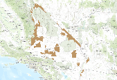
This is an aggregate dataset for the DRECP 12 km buffer region, depicting the geographic boundaries of Grazing Allotments within BLM managed public lands. An allotment is an area of land designated and managed for grazing of livestock (43 CFR 4100.0-5). An allotment may include private, state, and public lands under the jurisdiction of the Bureau of Land Management and/or other federal agencies. An allotment may be subdivided into pastures. Range improvement projects are not depicted within this dataset.
Data can be accessed through a map service (select one of the options in the grey bar above the inset map) or viewed in the BLM's GeoCommunicator interactive map.
Categories: Data,
Web Site;
Types: ArcGIS REST Map Service,
Map Service;
Tags: Allotment,
BLM,
GRA,
Grazing,
Livestock,
|

|
