Filters: Tags: GREEN LAKE (X)
115 results (90ms)|
Filters
Date Range
Extensions Types
Contacts
Categories Tag Types
|
This data set contains imagery from the National Agriculture Imagery Program (NAIP). The NAIP program is administered by USDA FSA and has been established to support two main FSA strategic goals centered on agricultural production. These are increase stewardship of America's natural resources while enhancing the environment, and to ensure commodities are procured and distributed effectively and efficiently to increase food security. The NAIP program supports these goals by acquiring and providing ortho imagery that has been collected during the agricultural growing season in the U.S. The NAIP ortho imagery is tailored to meet FSA requirements and is a fundamental tool used to support FSA farm and conservation programs....
This data set contains imagery from the National Agriculture Imagery Program (NAIP). The NAIP program is administered by USDA FSA and has been established to support two main FSA strategic goals centered on agricultural production. These are, increase stewardship of America's natural resources while enhancing the environment, and to ensure commodities are procured and distributed effectively and efficiently to increase food security. The NAIP program supports these goals by acquiring and providing ortho imagery that has been collected during the agricultural growing season in the U.S. The NAIP ortho imagery is tailored to meet FSA requirements and is a fundamental tool used to support FSA farm and conservation programs....
The 2018 lower East Rift Zone eruption of Kilauea Volcano began in the late afternoon of 3 May, with fissure 1 opening and erupting lava onto Mohala Street in the Leilani Estates subdivision, part of the lower Puna District of the Island of Hawai'i. For the first week of the eruption, relatively viscous lava flowed only within a kilometer (0.6 miles) of the fissures within Leilani Estates, before activity shifted downrift (east-northeast) and out of the subdivision during mid-May. Around 18 May, activity along the lower East Rift Zone intensified, and fluid lava erupting at higher effusion rates from the downrift fissures reached the ocean within two days. Near the end of May, this more vigorous activity shifted...
Categories: Data;
Types: Downloadable,
Map Service,
OGC WFS Layer,
OGC WMS Layer,
Shapefile;
Tags: East Rift Zone,
FissureLines,
Green Lake,
Hawai'i,
Hawaii,
The 2018 lower East Rift Zone eruption of Kilauea Volcano began in the late afternoon of 3 May, with fissure 1 opening and erupting lava onto Mohala Street in the Leilani Estates subdivision, part of the lower Puna District of the Island of Hawai'i. For the first week of the eruption, relatively viscous lava flowed only within a kilometer (0.6 miles) of the fissures within Leilani Estates, before activity shifted downrift (east-northeast) and out of the subdivision during mid-May. Around 18 May, activity along the lower East Rift Zone intensified, and fluid lava erupting at higher effusion rates from the downrift fissures reached the ocean within two days. Near the end of May, this more vigorous activity shifted...
Categories: Data;
Types: Downloadable,
Map Service,
OGC WFS Layer,
OGC WMS Layer,
Shapefile;
Tags: East Rift Zone,
FlowsOverlap,
Green Lake,
Hawai'i,
Hawaii,
The 2018 lower East Rift Zone eruption of Kilauea Volcano began in the late afternoon of 3 May, with fissure 1 opening and erupting lava onto Mohala Street in the Leilani Estates subdivision, part of the lower Puna District of the Island of Hawai'i. For the first week of the eruption, relatively viscous lava flowed only within a kilometer (0.6 miles) of the fissures within Leilani Estates, before activity shifted downrift (east-northeast) and out of the subdivision during mid-May. Around 18 May, activity along the lower East Rift Zone intensified, and fluid lava erupting at higher effusion rates from the downrift fissures reached the ocean within two days. Near the end of May, this more vigorous activity shifted...
Categories: Data;
Types: Downloadable,
Map Service,
OGC WFS Layer,
OGC WMS Layer,
Shapefile;
Tags: East Rift Zone,
Fissure03Flow,
Green Lake,
Hawai'i,
Hawaii,
The 2018 lower East Rift Zone eruption of Kilauea Volcano began in the late afternoon of 3 May, with fissure 1 opening and erupting lava onto Mohala Street in the Leilani Estates subdivision, part of the lower Puna District of the Island of Hawai'i. For the first week of the eruption, relatively viscous lava flowed only within a kilometer (0.6 miles) of the fissures within Leilani Estates, before activity shifted downrift (east-northeast) and out of the subdivision during mid-May. Around 18 May, activity along the lower East Rift Zone intensified, and fluid lava erupting at higher effusion rates from the downrift fissures reached the ocean within two days. Near the end of May, this more vigorous activity shifted...
Categories: Data;
Types: Downloadable,
Map Service,
OGC WFS Layer,
OGC WMS Layer,
Shapefile;
Tags: East Rift Zone,
Fissure14Flow,
Green Lake,
Hawai'i,
Hawaii,
The 2018 lower East Rift Zone eruption of Kilauea Volcano began in the late afternoon of 3 May, with fissure 1 opening and erupting lava onto Mohala Street in the Leilani Estates subdivision, part of the lower Puna District of the Island of Hawai'i. For the first week of the eruption, relatively viscous lava flowed only within a kilometer (0.6 miles) of the fissures within Leilani Estates, before activity shifted downrift (east-northeast) and out of the subdivision during mid-May. Around 18 May, activity along the lower East Rift Zone intensified, and fluid lava erupting at higher effusion rates from the downrift fissures reached the ocean within two days. Near the end of May, this more vigorous activity shifted...
Categories: Data;
Types: Downloadable,
Map Service,
OGC WFS Layer,
OGC WMS Layer,
Shapefile;
Tags: East Rift Zone,
Fissure18Flow,
Green Lake,
Hawai'i,
Hawaii,
The 2018 lower East Rift Zone eruption of Kilauea Volcano began in the late afternoon of 3 May, with fissure 1 opening and erupting lava onto Mohala Street in the Leilani Estates subdivision, part of the lower Puna District of the Island of Hawai'i. For the first week of the eruption, relatively viscous lava flowed only within a kilometer (0.6 miles) of the fissures within Leilani Estates, before activity shifted downrift (east-northeast) and out of the subdivision during mid-May. Around 18 May, activity along the lower East Rift Zone intensified, and fluid lava erupting at higher effusion rates from the downrift fissures reached the ocean within two days. Near the end of May, this more vigorous activity shifted...

USGS National Boundary Dataset (NBD) in Wisconsin State or Territory (published 20240215) GeoPackage
Geospatial data is comprised of government boundaries.
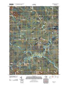
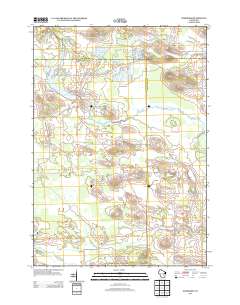
Layered GeoPDF 7.5 Minute Quadrangle Map. Layers of geospatial data include orthoimagery, roads, grids, geographic names, elevation contours, hydrography, and other selected map features.
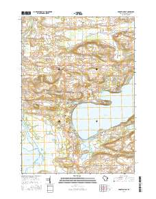
Layered geospatial PDF Map. Layers of geospatial data include orthoimagery, roads, grids, geographic names, elevation contours, hydrography, and other selected map features.
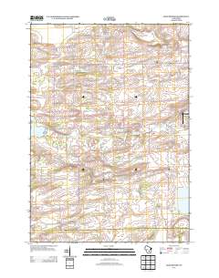
Layered GeoPDF 7.5 Minute Quadrangle Map. Layers of geospatial data include orthoimagery, roads, grids, geographic names, elevation contours, hydrography, and other selected map features.
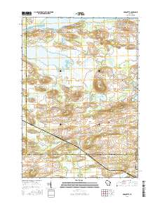
Layered geospatial PDF Map. Layers of geospatial data include orthoimagery, roads, grids, geographic names, elevation contours, hydrography, and other selected map features.
Layered GeoPDF 7.5 Minute Quadrangle Map. Layers of geospatial data include orthoimagery, roads, grids, geographic names, elevation contours, hydrography, and other selected map features.

This data represents the map extent for current and historical USGS topographic maps for the United States and Territories, including 1 X 2 Degree, 1 X 1 Degree, 30 X 60 Minute, 15 X 15 Minute, 7.5 X 7.5 Minute, and 3.75 X 3.75 Minute. The grid was generated using ESRI ArcInfo GIS software.
This data set contains imagery from the National Agriculture Imagery Program (NAIP). The NAIP program is administered by USDA FSA and has been established to support two main FSA strategic goals centered on agricultural production. These are, increase stewardship of America's natural resources while enhancing the environment, and to ensure commodities are procured and distributed effectively and efficiently to increase food security. The NAIP program supports these goals by acquiring and providing ortho imagery that has been collected during the agricultural growing season in the U.S. The NAIP ortho imagery is tailored to meet FSA requirements and is a fundamental tool used to support FSA farm and conservation programs....
This data set contains imagery from the National Agriculture Imagery Program (NAIP). The NAIP program is administered by USDA FSA and has been established to support two main FSA strategic goals centered on agricultural production. These are, increase stewardship of America's natural resources while enhancing the environment, and to ensure commodities are procured and distributed effectively and efficiently to increase food security. The NAIP program supports these goals by acquiring and providing ortho imagery that has been collected during the agricultural growing season in the U.S. The NAIP ortho imagery is tailored to meet FSA requirements and is a fundamental tool used to support FSA farm and conservation programs....
This data set contains imagery from the National Agriculture Imagery Program (NAIP). The NAIP program is administered by USDA FSA and has been established to support two main FSA strategic goals centered on agricultural production. These are, increase stewardship of America's natural resources while enhancing the environment, and to ensure commodities are procured and distributed effectively and efficiently to increase food security. The NAIP program supports these goals by acquiring and providing ortho imagery that has been collected during the agricultural growing season in the U.S. The NAIP ortho imagery is tailored to meet FSA requirements and is a fundamental tool used to support FSA farm and conservation programs....
This data set contains imagery from the National Agriculture Imagery Program (NAIP). The NAIP program is administered by USDA FSA and has been established to support two main FSA strategic goals centered on agricultural production. These are increase stewardship of America's natural resources while enhancing the environment, and to ensure commodities are procured and distributed effectively and efficiently to increase food security. The NAIP program supports these goals by acquiring and providing ortho imagery that has been collected during the agricultural growing season in the U.S. The NAIP ortho imagery is tailored to meet FSA requirements and is a fundamental tool used to support FSA farm and conservation programs....
This data set contains imagery from the National Agriculture Imagery Program (NAIP). The NAIP program is administered by USDA FSA and has been established to support two main FSA strategic goals centered on agricultural production. These are increase stewardship of America's natural resources while enhancing the environment, and to ensure commodities are procured and distributed effectively and efficiently to increase food security. The NAIP program supports these goals by acquiring and providing ortho imagery that has been collected during the agricultural growing season in the U.S. The NAIP ortho imagery is tailored to meet FSA requirements and is a fundamental tool used to support FSA farm and conservation programs....
|

|
