Filters
Date Range
Contacts
Tag Types
Tag Schemes
|

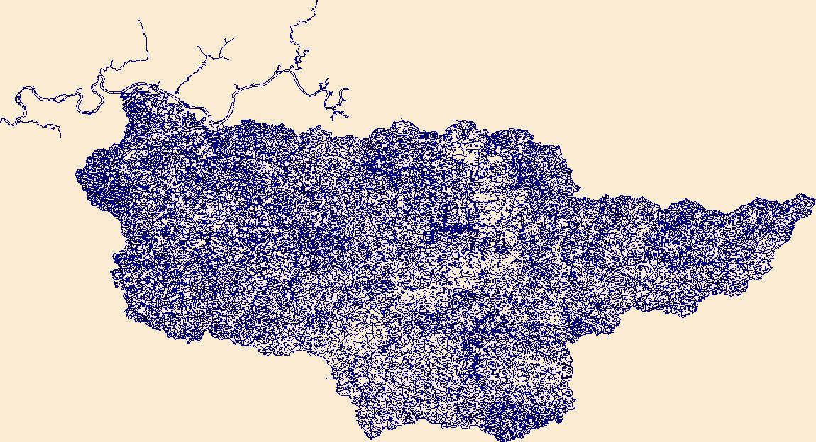
The High Resolution National Hydrography Dataset Plus (NHDPlus HR) is an integrated set of geospatial data layers, including the best available National Hydrography Dataset (NHD), the 10-meter 3D Elevation Program Digital Elevation Model (3DEP DEM), and the National Watershed Boundary Dataset (WBD). The NHDPlus HR combines the NHD, 3DEP DEMs, and WBD to create a stream network with linear referencing, feature naming, "value added attributes" (VAAs), elevation-derived catchments, and other features for hydrologic data analysis. The stream network with linear referencing is a system of data relationships applied to hydrographic systems so that one stream reach "flows" into another and "events" can be tied to and traced...
Tags: Archer County,
Baylor County,
Beckham County,
Briscoe County,
Bryan County, All tags...
Caddo County,
Canadian County,
Carter County,
Childress County,
Clay County,
Collingsworth County,
Comanche County,
Cooke County,
Cottle County,
Cotton County,
Crosby County,
Custer County,
Dewey County,
Dickens County,
Downloadable Data,
FileGDB,
FileGDB 10.1,
Floyd County,
Foard County,
Garvin County,
Grady County,
Gray County,
Grayson County,
HU-4 Subregion,
HU-4 Subregion,
HU4_1113,
Hale County,
Hall County,
Hardeman County,
Harmon County,
Hemphill County,
Hydrography,
Jackson County,
Jefferson County,
Johnston County,
King County,
Kiowa County,
Knox County,
Love County,
Marshall County,
McClain County,
Montague County,
Motley County,
Murray County,
NHDPlus HR Rasters,
NHDPlus High Resolution (NHDPlus HR),
National Hydrography Dataset (NHD),
National Hydrography Dataset Plus High Resolution (NHDPlus HR),
National Hydrography Dataset Plus High Resolution (NHDPlus HR) Current,
OK,
Oklahoma,
Pontotoc County,
Roberts County,
Roger Mills County,
Stephens County,
Swisher County,
TX,
Texas,
Tillman County,
US,
United States,
Washita County,
Wheeler County,
Wichita County,
Wilbarger County,
Young County,
base maps,
cartography,
catchments,
channels,
digital elevation models,
drainage basins,
earth sciences,
elevation,
environment,
geographic information systems,
geoscientific,
geospatial analysis,
hydrographic datasets,
hydrographic features,
hydrology,
imagery,
inland waters,
lakes,
land surface characteristics,
reservoirs,
river reaches,
rivers,
streamflow,
streamflow data,
streams,
topography,
water bodies,
water quality,
water resources,
watersheds, Fewer tags

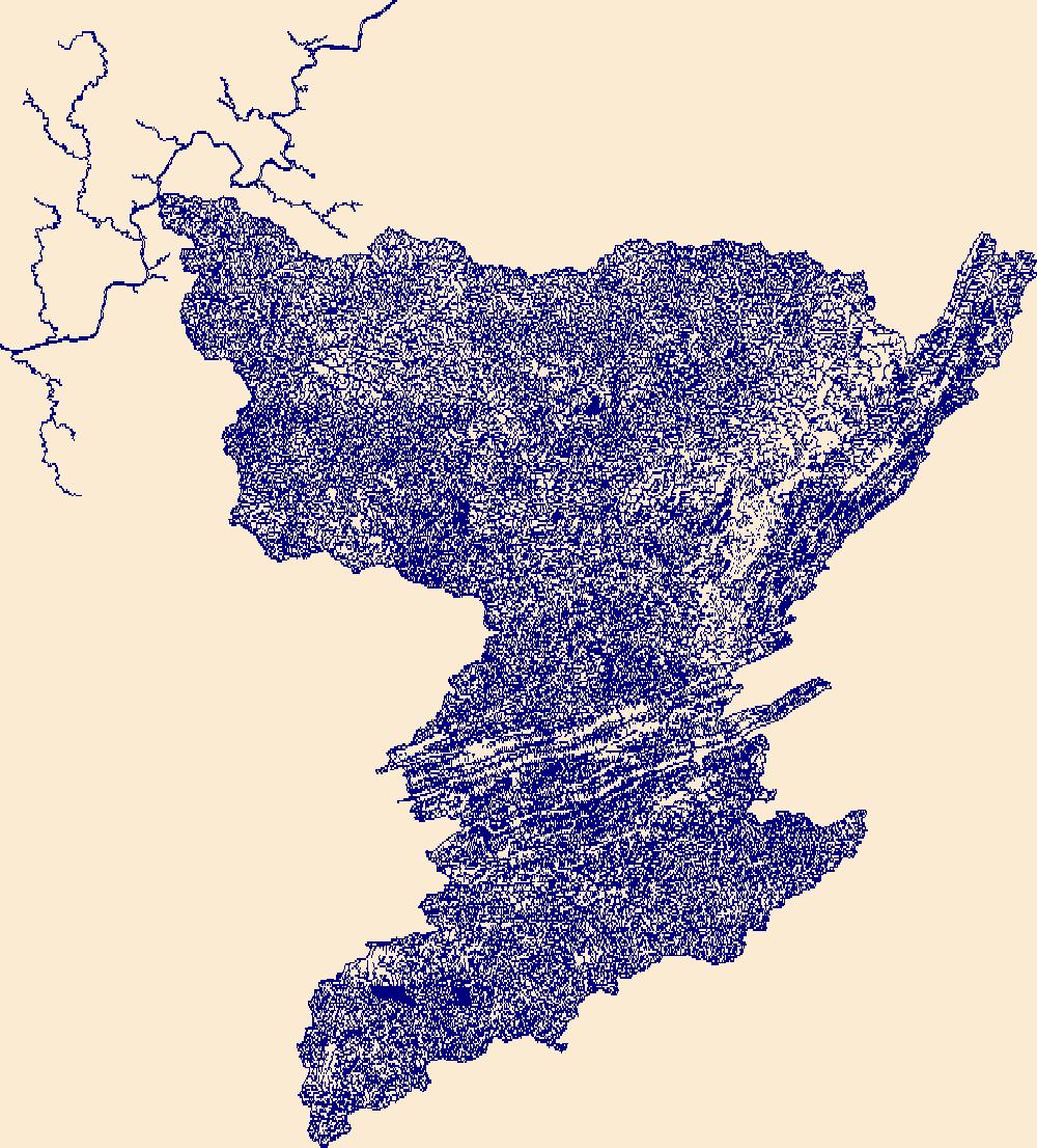
The High Resolution National Hydrography Dataset Plus (NHDPlus HR) is an integrated set of geospatial data layers, including the best available National Hydrography Dataset (NHD), the 10-meter 3D Elevation Program Digital Elevation Model (3DEP DEM), and the National Watershed Boundary Dataset (WBD). The NHDPlus HR combines the NHD, 3DEP DEMs, and WBD to create a stream network with linear referencing, feature naming, "value added attributes" (VAAs), elevation-derived catchments, and other features for hydrologic data analysis. The stream network with linear referencing is a system of data relationships applied to hydrographic systems so that one stream reach "flows" into another and "events" can be tied to and traced...
Tags: Anderson County,
Archer County,
Chambers County,
Clay County,
Collin County, All tags...
Cooke County,
Dallas County,
Denton County,
Downloadable Data,
Ellis County,
Fannin County,
FileGDB,
FileGDB 10.1,
Freestone County,
Grayson County,
Grimes County,
HU-4 Subregion,
HU-4 Subregion,
HU4_1203,
Hardin County,
Henderson County,
Hill County,
Hood County,
Houston County,
Hunt County,
Hydrography,
Jack County,
Johnson County,
Kaufman County,
Leon County,
Liberty County,
Limestone County,
Madison County,
Montague County,
NHDPlus HR Rasters,
NHDPlus High Resolution (NHDPlus HR),
National Hydrography Dataset (NHD),
National Hydrography Dataset Plus High Resolution (NHDPlus HR),
National Hydrography Dataset Plus High Resolution (NHDPlus HR) Current,
Navarro County,
Parker County,
Polk County,
Rockwall County,
San Jacinto County,
TX,
Tarrant County,
Texas,
Trinity County,
US,
United States,
Van Zandt County,
Walker County,
Wise County,
Young County,
base maps,
cartography,
catchments,
channels,
digital elevation models,
drainage basins,
earth sciences,
elevation,
environment,
geographic information systems,
geoscientific,
geospatial analysis,
hydrographic datasets,
hydrographic features,
hydrology,
imagery,
inland waters,
lakes,
land surface characteristics,
reservoirs,
river reaches,
rivers,
streamflow,
streamflow data,
streams,
topography,
water bodies,
water quality,
water resources,
watersheds, Fewer tags

The High Resolution National Hydrography Dataset Plus (NHDPlus HR) is an integrated set of geospatial data layers, including the best available National Hydrography Dataset (NHD), the 10-meter 3D Elevation Program Digital Elevation Model (3DEP DEM), and the National Watershed Boundary Dataset (WBD). The NHDPlus HR combines the NHD, 3DEP DEMs, and WBD to create a stream network with linear referencing, feature naming, "value added attributes" (VAAs), elevation-derived catchments, and other features for hydrologic data analysis. The stream network with linear referencing is a system of data relationships applied to hydrographic systems so that one stream reach "flows" into another and "events" can be tied to and traced...
Tags: AR,
Arkansas,
Atoka County,
Bienville County,
Bossier County, All tags...
Bowie County,
Bryan County,
Caddo County,
Camp County,
Cass County,
Choctaw County,
Claiborne County,
Coal County,
Columbia County,
De Soto County,
Delta County,
Downloadable Data,
Fannin County,
FileGDB,
FileGDB 10.1,
Franklin County,
Grant County,
Grayson County,
Gregg County,
HU-4 Subregion,
HU-4 Subregion,
HU4_1114,
Harrison County,
Hempstead County,
Hopkins County,
Howard County,
Hughes County,
Hunt County,
Hydrography,
Johnston County,
LA,
Lafayette County,
Lamar County,
Latimer County,
Le Flore County,
Lincoln County,
Little River County,
Louisiana,
Marion County,
McCurtain County,
Miller County,
Morris County,
Murray County,
NHDPlus HR Rasters,
NHDPlus High Resolution (NHDPlus HR),
Natchitoches County,
National Hydrography Dataset (NHD),
National Hydrography Dataset Plus High Resolution (NHDPlus HR),
National Hydrography Dataset Plus High Resolution (NHDPlus HR) Current,
Nevada County,
OK,
Oklahoma,
Panola County,
Pike County,
Pittsburg County,
Polk County,
Pontotoc County,
Pushmataha County,
Rapides County,
Red River County,
Red River County,
Sabine County,
Sevier County,
TX,
Texas,
Titus County,
US,
United States,
Upshur County,
Vernon County,
Webster County,
Winn County,
Wood County,
base maps,
cartography,
catchments,
channels,
digital elevation models,
drainage basins,
earth sciences,
elevation,
environment,
geographic information systems,
geoscientific,
geospatial analysis,
hydrographic datasets,
hydrographic features,
hydrology,
imagery,
inland waters,
lakes,
land surface characteristics,
reservoirs,
river reaches,
rivers,
streamflow,
streamflow data,
streams,
topography,
water bodies,
water quality,
water resources,
watersheds, Fewer tags
The High Resolution National Hydrography Dataset Plus (NHDPlus HR) is an integrated set of geospatial data layers, including the best available National Hydrography Dataset (NHD), the 10-meter 3D Elevation Program Digital Elevation Model (3DEP DEM), and the National Watershed Boundary Dataset (WBD). The NHDPlus HR combines the NHD, 3DEP DEMs, and WBD to create a stream network with linear referencing, feature naming, "value added attributes" (VAAs), elevation-derived catchments, and other features for hydrologic data analysis. The stream network with linear referencing is a system of data relationships applied to hydrographic systems so that one stream reach "flows" into another and "events" can be tied to and traced...
Tags: Adair County,
Allen County,
Barren County,
Breckinridge County,
Butler County, All tags...
Casey County,
Christian County,
Clay County,
Daviess County,
Downloadable Data,
Edmonson County,
FileGDB,
FileGDB 10.1,
Grayson County,
Green County,
HU-4 Subregion,
HU-4 Subregion,
HU4_0511,
Hancock County,
Hardin County,
Hart County,
Henderson County,
Hopkins County,
Hydrography,
Jackson County,
KY,
Kentucky,
Larue County,
Lincoln County,
Logan County,
Macon County,
Marion County,
McLean County,
Metcalfe County,
Monroe County,
Muhlenberg County,
NHDPlus HR Rasters,
NHDPlus High Resolution (NHDPlus HR),
National Hydrography Dataset (NHD),
National Hydrography Dataset Plus High Resolution (NHDPlus HR),
National Hydrography Dataset Plus High Resolution (NHDPlus HR) Current,
Ohio County,
Pulaski County,
Robertson County,
Russell County,
Simpson County,
Sumner County,
TN,
Taylor County,
Tennessee,
Todd County,
US,
United States,
Warren County,
Webster County,
base maps,
cartography,
catchments,
channels,
digital elevation models,
drainage basins,
earth sciences,
elevation,
environment,
geographic information systems,
geoscientific,
geospatial analysis,
hydrographic datasets,
hydrographic features,
hydrology,
imagery,
inland waters,
lakes,
land surface characteristics,
reservoirs,
river reaches,
rivers,
streamflow,
streamflow data,
streams,
topography,
water bodies,
water quality,
water resources,
watersheds, Fewer tags
The High Resolution National Hydrography Dataset Plus (NHDPlus HR) is an integrated set of geospatial data layers, including the best available National Hydrography Dataset (NHD), the 10-meter 3D Elevation Program Digital Elevation Model (3DEP DEM), and the National Watershed Boundary Dataset (WBD). The NHDPlus HR combines the NHD, 3DEP DEMs, and WBD to create a stream network with linear referencing, feature naming, "value added attributes" (VAAs), elevation-derived catchments, and other features for hydrologic data analysis. The stream network with linear referencing is a system of data relationships applied to hydrographic systems so that one stream reach "flows" into another and "events" can be tied to and traced...
Tags: Alleghany County,
Alleghany County,
Ashe County,
Bath County,
Bland County, All tags...
Boone County,
Braxton County,
Cabell County,
Caldwell County,
Calhoun County,
Carroll County,
Clay County,
Craig County,
Downloadable Data,
Fayette County,
FileGDB,
FileGDB 10.1,
Floyd County,
Franklin County,
Galax County,
Giles County,
Grayson County,
Greenbrier County,
HU-4 Subregion,
HU-4 Subregion,
HU4_0505,
Highland County,
Hydrography,
Jackson County,
Johnson County,
Kanawha County,
Lincoln County,
Logan County,
Mason County,
McDowell County,
Mercer County,
Monroe County,
Montgomery County,
NC,
NHDPlus HR Rasters,
NHDPlus High Resolution (NHDPlus HR),
National Hydrography Dataset (NHD),
National Hydrography Dataset Plus High Resolution (NHDPlus HR),
National Hydrography Dataset Plus High Resolution (NHDPlus HR) Current,
Nicholas County,
North Carolina,
Patrick County,
Pendleton County,
Pocahontas County,
Pulaski County,
Putnam County,
Radford County,
Raleigh County,
Randolph County,
Roane County,
Smyth County,
Summers County,
Surry County,
TN,
Tazewell County,
Tennessee,
US,
United States,
VA,
Virginia,
WV,
Washington County,
Watauga County,
Webster County,
West Virginia,
Wilkes County,
Wyoming County,
Wythe County,
base maps,
cartography,
catchments,
channels,
digital elevation models,
drainage basins,
earth sciences,
elevation,
environment,
geographic information systems,
geoscientific,
geospatial analysis,
hydrographic datasets,
hydrographic features,
hydrology,
imagery,
inland waters,
lakes,
land surface characteristics,
reservoirs,
river reaches,
rivers,
streamflow,
streamflow data,
streams,
topography,
water bodies,
water quality,
water resources,
watersheds, Fewer tags
|
|

