Filters: Tags: Ground water (X) > Categories: Data Release - Revised (X)
2 results (48ms)|
Filters
Date Range
Types Contacts
Categories Tag Types Tag Schemes |
A dataset of well information and geospatial data was developed for 426 U.S. Geological Survey (USGS) observation wells in Connecticut, Maine, Massachusetts, New Hampshire, Rhode Island, and Vermont. An extensive list of attributes is included about each well, its location, and water-level history to provide the public and water-resources community with comprehensive information on the USGS well network in New England and data available from these sites. These data may be useful for evaluating groundwater conditions and variability across the region. The well list and site attributes, which were extracted from USGS National Water Information System (NWIS), represent all of the active wells in the New England network...
Categories: Data,
Data Release - Revised;
Types: Map Service,
OGC WFS Layer,
OGC WMS Layer,
OGC WMS Service;
Tags: Aquifer,
Ground Water,
Hydrology,
Topographic setting,
USGS Science Data Catalog (SDC),
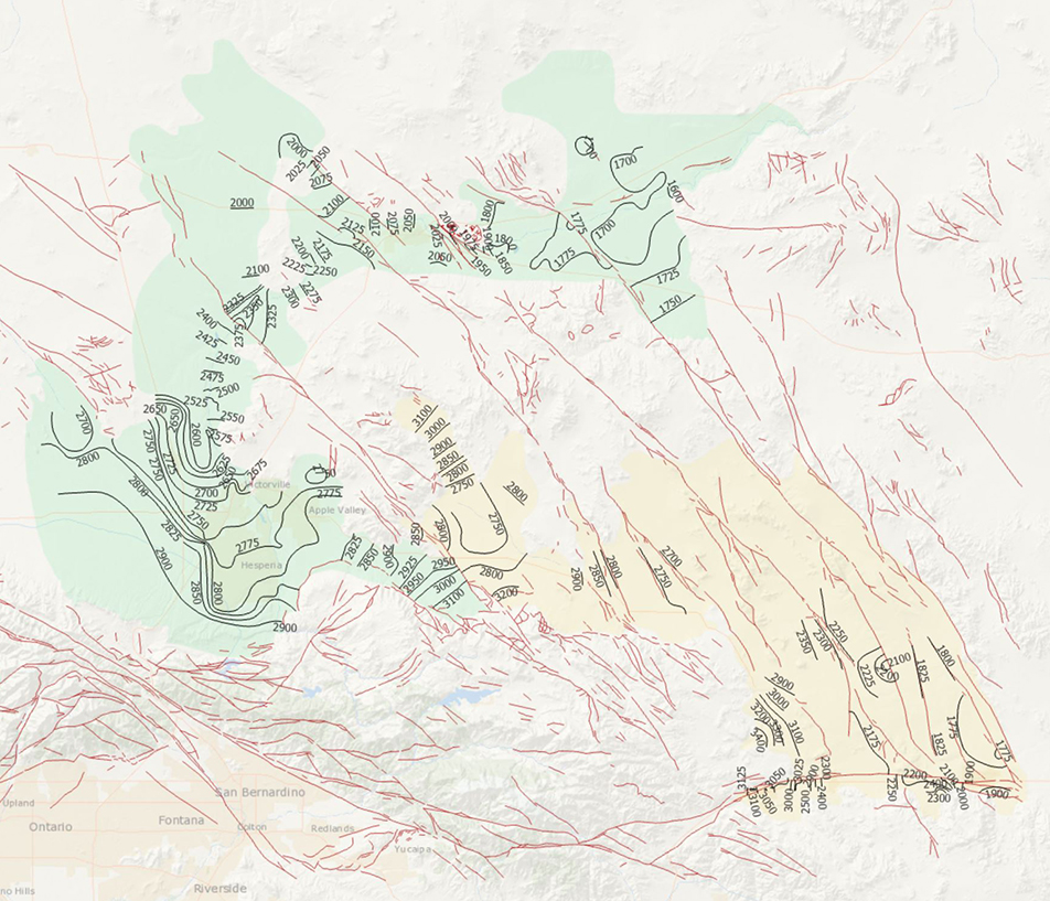
During 2014, the U.S. Geological Survey and other agencies made approximately 1,026 water-level measurements in the Mojave River and Morongo groundwater basins. These data document recent conditions and, when compared with previous data, changes in groundwater levels. A water-level contour map was drawn using data from about 610 wells, providing coverage for most of the basins. Twenty-four hydrographs show long-term (1930-2014) water-level conditions throughout the basins, and 9 short-term (1992 to 2014) hydrographs show the effects of recharge and discharge along the Mojave River. In addition, a water-level-change map was compiled to compare was compiled to compare the 2014 water levels to the 2012 water levels...
Categories: Data Release - Revised;
Tags: USGS,
USGS Science Data Catalog (SDC),
contours,
drainage basin,
ground water,
|

|
