Filters
Date Range
Contacts
Tag Types
Tag Schemes
|

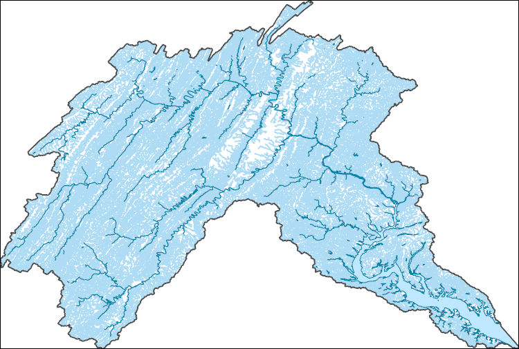
The High Resolution National Hydrography Dataset Plus (NHDPlus HR) is an integrated set of geospatial data layers, including the National Hydrography Dataset (NHD), National Watershed Boundary Dataset (WBD), and 3D Elevation Program Digital Elevation Model (3DEP DEM). The NHDPlus HR combines the NHD, 3DEP DEMs, and WBD to a data suite that includes the NHD stream network with linear referencing functionality, the WBD hydrologic units, elevation-derived catchment areas for each stream segment, "value added attributes" (VAAs), and other features that enhance hydrologic data analysis and routing.
Tags: 4-digit hydrologic unit,
Accomack County,
Adams County,
Albemarle County,
Alexandria County, All tags...
Allegany County,
Arlington County,
Augusta County,
Bedford County,
Berkeley County,
Carroll County,
Charles County,
Clarke County,
Cumberland County,
DC,
District of Columbia,
District of Columbia County,
Downloadable Data,
Fairfax County,
Falls Church County,
Fauquier County,
FileGDB,
Franklin County,
Frederick County,
Fulton County,
Garrett County,
Grant County,
Greene County,
HU-4 Subregion,
HU4,
HU4_0207,
Hampshire County,
Hardy County,
Harrisonburg County,
Highland County,
Huntingdon County,
Hydrography,
Jefferson County,
King George County,
Loudoun County,
MD,
Madison County,
Manassas County,
Manassas Park County,
Maryland,
Mineral County,
Montgomery County,
Morgan County,
NHDPlus HR Rasters,
NHDPlus High Resolution (NHDPlus HR),
National Hydrography Dataset (NHD),
National Hydrography Dataset Plus High Resolution (NHDPlus HR),
National Hydrography Dataset Plus High Resolution (NHDPlus HR) Current,
Nelson County,
Northumberland County,
PA,
Page County,
Pendleton County,
Pennsylvania,
Perry County,
Pocahontas County,
Preston County,
Prince George's County,
Prince William County,
Randolph County,
Rappahannock County,
Richmond County,
Rockingham County,
Shenandoah County,
Somerset County,
St. Mary's County,
Stafford County,
Staunton County,
Tucker County,
US,
United States,
VA,
Virginia,
WV,
Warren County,
Washington County,
Waynesboro County,
West Virginia,
Westmoreland County,
Winchester County,
base maps,
cartography,
catchments,
channels,
digital elevation models,
drainage basins,
earthsciences,
environment,
geographic information systems,
geoscientificInformation,
geospatial analysis,
hydrographic datasets,
hydrographic features,
hydrology,
inlandWaters,
lakes,
land surface characteristics,
reservoirs,
river reaches,
rivers,
streamflow,
streamflow data,
streams,
surface water quality,
topography,
water resources,
waterbodies,
watersheds, Fewer tags

The National Hydrography Dataset (NHD) is a feature-based database that interconnects and uniquely identifies the stream segments or reaches that make up the nation's surface water drainage system. NHD data was originally developed at 1:100,000-scale and exists at that scale for the whole country. This high-resolution NHD, generally developed at 1:24,000/1:12,000 scale, adds detail to the original 1:100,000-scale NHD. (Data for Alaska, Puerto Rico and the Virgin Islands was developed at high-resolution, not 1:100,000 scale.) Local resolution NHD is being developed where partners and data exist. The NHD contains reach codes for networked features, flow direction, names, and centerline representations for areal water...
Tags: Accomack,
Adams,
Administrative watershed units,
Administrative watershed units,
Albemarle, All tags...
Alexandria,
Allegany,
Area of Complex Channels,
Area to be submerged,
Arlington,
Augusta,
Basin,
Basin,
Bay/Inlet,
Bedford,
Berkeley,
Boundaries,
Boundary,
Bridge,
Canal/Ditch,
Carroll,
Charles,
Clarke,
Coastline,
Connector,
Cumberland,
DC,
Dam/Weir,
District of Columbia,
District of Columbia,
Downloadable Data,
Drainage areas for surface water,
Drainageway,
Esri File GeoDatabase 10,
Estuary,
Fairfax,
Falls Church,
Fauquier,
FileGDB,
Flow direction network,
Flume,
ForeShore,
Franklin,
Frederick,
Fulton,
Gaging Station,
Garrett,
Gate,
Grant,
Greene,
HU-4,
HU-4 Subregion,
HU10,
HU12,
HU14,
HU16,
HU2,
HU4,
HU4_0207,
HU6,
HU8,
HUC,
Hampshire,
Hardy,
Harrisonburg,
Hazard Zone,
Highland,
Huntingdon,
Hydrographic,
Hydrography,
Hydrography,
Hydrography,
Hydrologic Unit Code,
Hydrologic Units,
Ice mass,
Inundation Area,
Jefferson,
King George,
Levee,
Line,
Lock Chamber,
Loudoun,
MD,
Madison,
Manassas,
Manassas Park,
Marsh,
Maryland,
Mineral,
Montgomery,
Morgan,
National Hydrography Dataset (NHD),
National Hydrography Dataset (NHD) Best Resolution,
National Hydrography Dataset (NHD) Best Resolution,
Nelson,
Nonearthen Shore,
Northumberland,
Orthoimage,
PA,
Page,
Pendleton,
Pennsylvania,
Perry,
Playa,
Pocahontas,
Point,
PointEvent,
Pond,
Preston,
Prince George's,
Prince William,
Randolph,
Rapids,
Rapids,
Rappahannock,
Reach,
Reach code,
Reef,
Region,
Reservoir,
Richmond,
Rock,
Rockingham,
Sea/Ocean,
Shenandoah,
Sink/Rise,
Somerset,
Sounding Datum Line,
Special Use Zone,
Special Use Zone Limit,
Spillway,
St. Mary's,
Stafford,
Staunton,
Stream,
Stream/River,
Sub-basin,
Sub-region,
Subbasin,
Submerged Stream,
Subregion,
Subwatershed,
Surface water systems,
Swamp,
Topographic,
Tucker,
Tunnel,
US,
Underground Conduit,
United States,
VA,
Virginia,
WBD,
WBD,
WV,
Wall,
Warren,
Wash,
Washington,
Water Intake Outflow,
Waterfall,
Watershed,
Watershed Boundaries,
Watershed Boundary Dataset,
Watershed Boundary Dataset,
Waynesboro,
Well,
West Virginia,
Westmoreland,
Winchester,
artificial path,
boundaries,
dams,
drainage systems and characteristics,
inlandWaters,
lakes,
ngda,
rivers, Fewer tags
The National Hydrography Dataset (NHD) is a feature-based database that interconnects and uniquely identifies the stream segments or reaches that make up the nation's surface water drainage system. NHD data was originally developed at 1:100,000-scale and exists at that scale for the whole country. This high-resolution NHD, generally developed at 1:24,000/1:12,000 scale, adds detail to the original 1:100,000-scale NHD. (Data for Alaska, Puerto Rico and the Virgin Islands was developed at high-resolution, not 1:100,000 scale.) Local resolution NHD is being developed where partners and data exist. The NHD contains reach codes for networked features, flow direction, names, and centerline representations for areal water...
Tags: Accomack,
Adams,
Administrative watershed units,
Administrative watershed units,
Albemarle, All tags...
Alexandria,
Allegany,
Area of Complex Channels,
Area to be submerged,
Arlington,
Augusta,
Basin,
Basin,
Bay/Inlet,
Bedford,
Berkeley,
Boundaries,
Boundary,
Bridge,
Canal/Ditch,
Carroll,
Charles,
Clarke,
Coastline,
Connector,
Cumberland,
DC,
Dam/Weir,
District of Columbia,
District of Columbia,
Downloadable Data,
Drainage areas for surface water,
Drainageway,
Estuary,
Fairfax,
Falls Church,
Fauquier,
Flow direction network,
Flume,
ForeShore,
Franklin,
Frederick,
Fulton,
Gaging Station,
Garrett,
Gate,
GeoPackage,
Grant,
Greene,
HU-4,
HU-4 Subregion,
HU10,
HU12,
HU14,
HU16,
HU2,
HU4,
HU4_0207,
HU6,
HU8,
HUC,
Hampshire,
Hardy,
Harrisonburg,
Hazard Zone,
Highland,
Huntingdon,
Hydrographic,
Hydrography,
Hydrography,
Hydrography,
Hydrologic Unit Code,
Hydrologic Units,
Ice mass,
Inundation Area,
Jefferson,
King George,
Levee,
Line,
Lock Chamber,
Loudoun,
MD,
Madison,
Manassas,
Manassas Park,
Marsh,
Maryland,
Mineral,
Montgomery,
Morgan,
National Hydrography Dataset (NHD),
National Hydrography Dataset (NHD) Best Resolution,
National Hydrography Dataset (NHD) Best Resolution,
Nelson,
Nonearthen Shore,
Northumberland,
Open Geospatial Consortium GeoPackage 1.2,
Orthoimage,
PA,
Page,
Pendleton,
Pennsylvania,
Perry,
Playa,
Pocahontas,
Point,
PointEvent,
Pond,
Preston,
Prince George's,
Prince William,
Randolph,
Rapids,
Rapids,
Rappahannock,
Reach,
Reach code,
Reef,
Region,
Reservoir,
Richmond,
Rock,
Rockingham,
Sea/Ocean,
Shenandoah,
Sink/Rise,
Somerset,
Sounding Datum Line,
Special Use Zone,
Special Use Zone Limit,
Spillway,
St. Mary's,
Stafford,
Staunton,
Stream,
Stream/River,
Sub-basin,
Sub-region,
Subbasin,
Submerged Stream,
Subregion,
Subwatershed,
Surface water systems,
Swamp,
Topographic,
Tucker,
Tunnel,
US,
Underground Conduit,
United States,
VA,
Virginia,
WBD,
WBD,
WV,
Wall,
Warren,
Wash,
Washington,
Water Intake Outflow,
Waterfall,
Watershed,
Watershed Boundaries,
Watershed Boundary Dataset,
Watershed Boundary Dataset,
Waynesboro,
Well,
West Virginia,
Westmoreland,
Winchester,
artificial path,
boundaries,
dams,
drainage systems and characteristics,
inlandWaters,
lakes,
ngda,
rivers, Fewer tags

The National Hydrography Dataset (NHD) is a feature-based database that interconnects and uniquely identifies the stream segments or reaches that make up the nation's surface water drainage system. NHD data was originally developed at 1:100,000-scale and exists at that scale for the whole country. This high-resolution NHD, generally developed at 1:24,000/1:12,000 scale, adds detail to the original 1:100,000-scale NHD. (Data for Alaska, Puerto Rico and the Virgin Islands was developed at high-resolution, not 1:100,000 scale.) Local resolution NHD is being developed where partners and data exist. The NHD contains reach codes for networked features, flow direction, names, and centerline representations for areal water...
Tags: Accomack,
Adams,
Administrative watershed units,
Administrative watershed units,
Albemarle, All tags...
Alexandria,
Allegany,
Area of Complex Channels,
Area to be submerged,
Arlington,
Augusta,
Basin,
Basin,
Bay/Inlet,
Bedford,
Berkeley,
Boundaries,
Boundary,
Bridge,
Canal/Ditch,
Carroll,
Charles,
Clarke,
Coastline,
Connector,
Cumberland,
DC,
Dam/Weir,
District of Columbia,
District of Columbia,
Downloadable Data,
Drainage areas for surface water,
Drainageway,
Esri Shapefile nan,
Estuary,
Fairfax,
Falls Church,
Fauquier,
Flow direction network,
Flume,
ForeShore,
Franklin,
Frederick,
Fulton,
Gaging Station,
Garrett,
Gate,
Grant,
Greene,
HU-4,
HU-4 Subregion,
HU10,
HU12,
HU14,
HU16,
HU2,
HU4,
HU4_0207,
HU6,
HU8,
HUC,
Hampshire,
Hardy,
Harrisonburg,
Hazard Zone,
Highland,
Huntingdon,
Hydrographic,
Hydrography,
Hydrography,
Hydrography,
Hydrologic Unit Code,
Hydrologic Units,
Ice mass,
Inundation Area,
Jefferson,
King George,
Levee,
Line,
Lock Chamber,
Loudoun,
MD,
Madison,
Manassas,
Manassas Park,
Marsh,
Maryland,
Mineral,
Montgomery,
Morgan,
National Hydrography Dataset (NHD),
National Hydrography Dataset (NHD) Best Resolution,
National Hydrography Dataset (NHD) Best Resolution,
Nelson,
Nonearthen Shore,
Northumberland,
Orthoimage,
PA,
Page,
Pendleton,
Pennsylvania,
Perry,
Playa,
Pocahontas,
Point,
PointEvent,
Pond,
Preston,
Prince George's,
Prince William,
Randolph,
Rapids,
Rapids,
Rappahannock,
Reach,
Reach code,
Reef,
Region,
Reservoir,
Richmond,
Rock,
Rockingham,
Sea/Ocean,
Shapefile,
Shenandoah,
Sink/Rise,
Somerset,
Sounding Datum Line,
Special Use Zone,
Special Use Zone Limit,
Spillway,
St. Mary's,
Stafford,
Staunton,
Stream,
Stream/River,
Sub-basin,
Sub-region,
Subbasin,
Submerged Stream,
Subregion,
Subwatershed,
Surface water systems,
Swamp,
Topographic,
Tucker,
Tunnel,
US,
Underground Conduit,
United States,
VA,
Virginia,
WBD,
WBD,
WV,
Wall,
Warren,
Wash,
Washington,
Water Intake Outflow,
Waterfall,
Watershed,
Watershed Boundaries,
Watershed Boundary Dataset,
Watershed Boundary Dataset,
Waynesboro,
Well,
West Virginia,
Westmoreland,
Winchester,
artificial path,
boundaries,
dams,
drainage systems and characteristics,
inlandWaters,
lakes,
ngda,
rivers, Fewer tags
|
|

