Filters
Date Range
Contacts
Tag Types
Tag Schemes
|
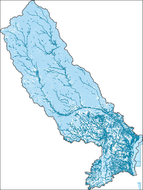
The National Hydrography Dataset (NHD) is a feature-based database that interconnects and uniquely identifies the stream segments or reaches that make up the nation's surface water drainage system. NHD data was originally developed at 1:100,000-scale and exists at that scale for the whole country. This high-resolution NHD, generally developed at 1:24,000/1:12,000 scale, adds detail to the original 1:100,000-scale NHD. (Data for Alaska, Puerto Rico and the Virgin Islands was developed at high-resolution, not 1:100,000 scale.) Local resolution NHD is being developed where partners and data exist. The NHD contains reach codes for networked features, flow direction, names, and centerline representations for areal water...
Tags: Administrative watershed units,
Administrative watershed units,
Appling,
Area of Complex Channels,
Area to be submerged, All tags...
Atkinson,
Bacon,
Baker,
Baldwin,
Banks,
Barrow,
Basin,
Basin,
Bay/Inlet,
Ben Hill,
Bibb,
Bleckley,
Boundaries,
Boundary,
Brantley,
Bridge,
Butts,
Camden,
Canal/Ditch,
Candler,
Charlton,
Clarke,
Clayton,
Clinch,
Coastline,
Coffee,
Columbia,
Connector,
Crawford,
Dam/Weir,
DeKalb,
Dodge,
Dooly,
Downloadable Data,
Drainage areas for surface water,
Drainageway,
Duval,
Emanuel,
Esri Shapefile nan,
Estuary,
Evans,
FL,
Florida,
Flow direction network,
Flume,
ForeShore,
Fulton,
GA,
Gaging Station,
Gate,
Georgia,
Glynn,
Greene,
Gwinnett,
HU-4,
HU-4 Subregion,
HU10,
HU12,
HU14,
HU16,
HU2,
HU4,
HU4_0307,
HU6,
HU8,
HUC,
Hall,
Hancock,
Hazard Zone,
Henry,
Houston,
Hydrographic,
Hydrography,
Hydrography,
Hydrography,
Hydrologic Unit Code,
Hydrologic Units,
Ice mass,
Inundation Area,
Irwin,
Jackson,
Jasper,
Jeff Davis,
Jefferson,
Johnson,
Jones,
Lamar,
Laurens,
Levee,
Liberty,
Line,
Lock Chamber,
Long,
Macon,
Madison,
Marsh,
McIntosh,
Monroe,
Montgomery,
Morgan,
Nassau,
National Hydrography Dataset (NHD),
National Hydrography Dataset (NHD) Best Resolution,
National Hydrography Dataset (NHD) Best Resolution,
Newton,
Nonearthen Shore,
Oconee,
Oglethorpe,
Orthoimage,
Peach,
Pierce,
Playa,
Point,
PointEvent,
Pond,
Pulaski,
Putnam,
Rapids,
Rapids,
Reach,
Reach code,
Reef,
Region,
Reservoir,
Rock,
Rockdale,
Sea/Ocean,
Shapefile,
Sink/Rise,
Sounding Datum Line,
Spalding,
Special Use Zone,
Special Use Zone Limit,
Spillway,
Stream,
Stream/River,
Sub-basin,
Sub-region,
Subbasin,
Submerged Stream,
Subregion,
Subwatershed,
Surface water systems,
Swamp,
Taliaferro,
Tattnall,
Telfair,
Toombs,
Topographic,
Treutlen,
Tunnel,
Twiggs,
US,
Underground Conduit,
Union,
United States,
Upson,
WBD,
WBD,
Wall,
Walton,
Ware,
Wash,
Washington,
Water Intake Outflow,
Waterfall,
Watershed,
Watershed Boundaries,
Watershed Boundary Dataset,
Watershed Boundary Dataset,
Wayne,
Well,
Wheeler,
Wilcox,
Wilkinson,
artificial path,
boundaries,
dams,
drainage systems and characteristics,
inlandWaters,
lakes,
ngda,
rivers, Fewer tags

The National Hydrography Dataset (NHD) is a feature-based database that interconnects and uniquely identifies the stream segments or reaches that make up the nation's surface water drainage system. NHD data was originally developed at 1:100,000-scale and exists at that scale for the whole country. This high-resolution NHD, generally developed at 1:24,000/1:12,000 scale, adds detail to the original 1:100,000-scale NHD. (Data for Alaska, Puerto Rico and the Virgin Islands was developed at high-resolution, not 1:100,000 scale.) Local resolution NHD is being developed where partners and data exist. The NHD contains reach codes for networked features, flow direction, names, and centerline representations for areal water...
Tags: Administrative watershed units,
Administrative watershed units,
Appling,
Area of Complex Channels,
Area to be submerged, All tags...
Atkinson,
Bacon,
Baker,
Baldwin,
Banks,
Barrow,
Basin,
Basin,
Bay/Inlet,
Ben Hill,
Bibb,
Bleckley,
Boundaries,
Boundary,
Brantley,
Bridge,
Butts,
Camden,
Canal/Ditch,
Candler,
Charlton,
Clarke,
Clayton,
Clinch,
Coastline,
Coffee,
Columbia,
Connector,
Crawford,
Dam/Weir,
DeKalb,
Dodge,
Dooly,
Downloadable Data,
Drainage areas for surface water,
Drainageway,
Duval,
Emanuel,
Esri File GeoDatabase 10,
Estuary,
Evans,
FL,
FileGDB,
Florida,
Flow direction network,
Flume,
ForeShore,
Fulton,
GA,
Gaging Station,
Gate,
Georgia,
Glynn,
Greene,
Gwinnett,
HU-4,
HU-4 Subregion,
HU10,
HU12,
HU14,
HU16,
HU2,
HU4,
HU4_0307,
HU6,
HU8,
HUC,
Hall,
Hancock,
Hazard Zone,
Henry,
Houston,
Hydrographic,
Hydrography,
Hydrography,
Hydrography,
Hydrologic Unit Code,
Hydrologic Units,
Ice mass,
Inundation Area,
Irwin,
Jackson,
Jasper,
Jeff Davis,
Jefferson,
Johnson,
Jones,
Lamar,
Laurens,
Levee,
Liberty,
Line,
Lock Chamber,
Long,
Macon,
Madison,
Marsh,
McIntosh,
Monroe,
Montgomery,
Morgan,
Nassau,
National Hydrography Dataset (NHD),
National Hydrography Dataset (NHD) Best Resolution,
National Hydrography Dataset (NHD) Best Resolution,
Newton,
Nonearthen Shore,
Oconee,
Oglethorpe,
Orthoimage,
Peach,
Pierce,
Playa,
Point,
PointEvent,
Pond,
Pulaski,
Putnam,
Rapids,
Rapids,
Reach,
Reach code,
Reef,
Region,
Reservoir,
Rock,
Rockdale,
Sea/Ocean,
Sink/Rise,
Sounding Datum Line,
Spalding,
Special Use Zone,
Special Use Zone Limit,
Spillway,
Stream,
Stream/River,
Sub-basin,
Sub-region,
Subbasin,
Submerged Stream,
Subregion,
Subwatershed,
Surface water systems,
Swamp,
Taliaferro,
Tattnall,
Telfair,
Toombs,
Topographic,
Treutlen,
Tunnel,
Twiggs,
US,
Underground Conduit,
Union,
United States,
Upson,
WBD,
WBD,
Wall,
Walton,
Ware,
Wash,
Washington,
Water Intake Outflow,
Waterfall,
Watershed,
Watershed Boundaries,
Watershed Boundary Dataset,
Watershed Boundary Dataset,
Wayne,
Well,
Wheeler,
Wilcox,
Wilkinson,
artificial path,
boundaries,
dams,
drainage systems and characteristics,
inlandWaters,
lakes,
ngda,
rivers, Fewer tags

The High Resolution National Hydrography Dataset Plus (NHDPlus HR) is an integrated set of geospatial data layers, including the best available National Hydrography Dataset (NHD), the 10-meter 3D Elevation Program Digital Elevation Model (3DEP DEM), and the National Watershed Boundary Dataset (WBD). The NHDPlus HR combines the NHD, 3DEP DEMs, and WBD to create a stream network with linear referencing, feature naming, "value added attributes" (VAAs), elevation-derived catchments, and other features for hydrologic data analysis. The stream network with linear referencing is a system of data relationships applied to hydrographic systems so that one stream reach "flows" into another and "events" can be tied to and traced...
Tags: Appling County,
Atkinson County,
Bacon County,
Baker County,
Baldwin County, All tags...
Banks County,
Barrow County,
Ben Hill County,
Bibb County,
Bleckley County,
Brantley County,
Butts County,
Camden County,
Candler County,
Charlton County,
Clarke County,
Clayton County,
Clinch County,
Coffee County,
Columbia County,
Crawford County,
DeKalb County,
Dodge County,
Dooly County,
Downloadable Data,
Duval County,
Emanuel County,
Evans County,
FL,
FileGDB,
FileGDB 10.1,
Florida,
Fulton County,
GA,
Georgia,
Glynn County,
Greene County,
Gwinnett County,
HU-4 Subregion,
HU-4 Subregion,
HU4_0307,
Hall County,
Hancock County,
Henry County,
Houston County,
Hydrography,
Irwin County,
Jackson County,
Jasper County,
Jeff Davis County,
Jefferson County,
Johnson County,
Jones County,
Lamar County,
Laurens County,
Liberty County,
Long County,
Macon County,
Madison County,
McIntosh County,
Monroe County,
Montgomery County,
Morgan County,
NHDPlus HR Rasters,
NHDPlus High Resolution (NHDPlus HR),
Nassau County,
National Hydrography Dataset (NHD),
National Hydrography Dataset Plus High Resolution (NHDPlus HR),
National Hydrography Dataset Plus High Resolution (NHDPlus HR) Current,
Newton County,
Oconee County,
Oglethorpe County,
Peach County,
Pierce County,
Pulaski County,
Putnam County,
Rockdale County,
Spalding County,
Taliaferro County,
Tattnall County,
Telfair County,
Toombs County,
Treutlen County,
Twiggs County,
US,
Union County,
United States,
Upson County,
Walton County,
Ware County,
Washington County,
Wayne County,
Wheeler County,
Wilcox County,
Wilkinson County,
base maps,
cartography,
catchments,
channels,
digital elevation models,
drainage basins,
earth sciences,
elevation,
environment,
geographic information systems,
geoscientific,
geospatial analysis,
hydrographic datasets,
hydrographic features,
hydrology,
imagery,
inland waters,
lakes,
land surface characteristics,
reservoirs,
river reaches,
rivers,
streamflow,
streamflow data,
streams,
topography,
water bodies,
water quality,
water resources,
watersheds, Fewer tags

The National Hydrography Dataset (NHD) is a feature-based database that interconnects and uniquely identifies the stream segments or reaches that make up the nation's surface water drainage system. NHD data was originally developed at 1:100,000-scale and exists at that scale for the whole country. This high-resolution NHD, generally developed at 1:24,000/1:12,000 scale, adds detail to the original 1:100,000-scale NHD. (Data for Alaska, Puerto Rico and the Virgin Islands was developed at high-resolution, not 1:100,000 scale.) Local resolution NHD is being developed where partners and data exist. The NHD contains reach codes for networked features, flow direction, names, and centerline representations for areal water...
Tags: Administrative watershed units,
Administrative watershed units,
Appling,
Area of Complex Channels,
Area to be submerged, All tags...
Atkinson,
Bacon,
Baker,
Baldwin,
Banks,
Barrow,
Basin,
Basin,
Bay/Inlet,
Ben Hill,
Bibb,
Bleckley,
Boundaries,
Boundary,
Brantley,
Bridge,
Butts,
Camden,
Canal/Ditch,
Candler,
Charlton,
Clarke,
Clayton,
Clinch,
Coastline,
Coffee,
Columbia,
Connector,
Crawford,
Dam/Weir,
DeKalb,
Dodge,
Dooly,
Downloadable Data,
Drainage areas for surface water,
Drainageway,
Duval,
Emanuel,
Estuary,
Evans,
FL,
Florida,
Flow direction network,
Flume,
ForeShore,
Fulton,
GA,
Gaging Station,
Gate,
GeoPackage,
Georgia,
Glynn,
Greene,
Gwinnett,
HU-4,
HU-4 Subregion,
HU10,
HU12,
HU14,
HU16,
HU2,
HU4,
HU4_0307,
HU6,
HU8,
HUC,
Hall,
Hancock,
Hazard Zone,
Henry,
Houston,
Hydrographic,
Hydrography,
Hydrography,
Hydrography,
Hydrologic Unit Code,
Hydrologic Units,
Ice mass,
Inundation Area,
Irwin,
Jackson,
Jasper,
Jeff Davis,
Jefferson,
Johnson,
Jones,
Lamar,
Laurens,
Levee,
Liberty,
Line,
Lock Chamber,
Long,
Macon,
Madison,
Marsh,
McIntosh,
Monroe,
Montgomery,
Morgan,
Nassau,
National Hydrography Dataset (NHD),
National Hydrography Dataset (NHD) Best Resolution,
National Hydrography Dataset (NHD) Best Resolution,
Newton,
Nonearthen Shore,
Oconee,
Oglethorpe,
Open Geospatial Consortium GeoPackage 1.2,
Orthoimage,
Peach,
Pierce,
Playa,
Point,
PointEvent,
Pond,
Pulaski,
Putnam,
Rapids,
Rapids,
Reach,
Reach code,
Reef,
Region,
Reservoir,
Rock,
Rockdale,
Sea/Ocean,
Sink/Rise,
Sounding Datum Line,
Spalding,
Special Use Zone,
Special Use Zone Limit,
Spillway,
Stream,
Stream/River,
Sub-basin,
Sub-region,
Subbasin,
Submerged Stream,
Subregion,
Subwatershed,
Surface water systems,
Swamp,
Taliaferro,
Tattnall,
Telfair,
Toombs,
Topographic,
Treutlen,
Tunnel,
Twiggs,
US,
Underground Conduit,
Union,
United States,
Upson,
WBD,
WBD,
Wall,
Walton,
Ware,
Wash,
Washington,
Water Intake Outflow,
Waterfall,
Watershed,
Watershed Boundaries,
Watershed Boundary Dataset,
Watershed Boundary Dataset,
Wayne,
Well,
Wheeler,
Wilcox,
Wilkinson,
artificial path,
boundaries,
dams,
drainage systems and characteristics,
inlandWaters,
lakes,
ngda,
rivers, Fewer tags
|
|

