Filters
Date Range
Contacts
Tag Types
Tag Schemes
|

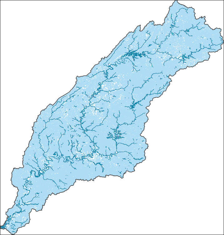
The National Hydrography Dataset (NHD) is a feature-based database that interconnects and uniquely identifies the stream segments or reaches that make up the nation's surface water drainage system. NHD data was originally developed at 1:100,000-scale and exists at that scale for the whole country. This high-resolution NHD, generally developed at 1:24,000/1:12,000 scale, adds detail to the original 1:100,000-scale NHD. (Data for Alaska, Puerto Rico and the Virgin Islands was developed at high-resolution, not 1:100,000 scale.) Local resolution NHD is being developed where partners and data exist. The NHD contains reach codes for networked features, flow direction, names, and centerline representations for areal water...
Tags: AL,
Administrative watershed units,
Administrative watershed units,
Alabama,
Area of Complex Channels, All tags...
Area to be submerged,
Autauga,
Baldwin,
Bartow,
Basin,
Basin,
Bay/Inlet,
Bibb,
Blount,
Boundaries,
Boundary,
Bradley,
Bridge,
Bullock,
Butler,
Calhoun,
Canal/Ditch,
Carroll,
Chambers,
Chattooga,
Cherokee,
Chilton,
Clarke,
Clay,
Cleburne,
Coastline,
Cobb,
Conecuh,
Connector,
Coosa,
Crenshaw,
Dade,
Dallas,
Dam/Weir,
Dawson,
DeKalb,
Douglas,
Downloadable Data,
Drainage areas for surface water,
Drainageway,
Elmore,
Escambia,
Estuary,
Etowah,
Fannin,
Flow direction network,
Floyd,
Flume,
ForeShore,
Forsyth,
Fulton,
GA,
Gaging Station,
Gate,
GeoPackage,
Georgia,
Gilmer,
Gordon,
HU-4,
HU-4 Subregion,
HU10,
HU12,
HU14,
HU16,
HU2,
HU4,
HU4_0315,
HU6,
HU8,
HUC,
Hamilton,
Haralson,
Hazard Zone,
Heard,
Hydrographic,
Hydrography,
Hydrography,
Hydrography,
Hydrologic Unit Code,
Hydrologic Units,
Ice mass,
Inundation Area,
Jefferson,
Lee,
Levee,
Line,
Lock Chamber,
Lowndes,
Lumpkin,
Macon,
Marengo,
Marsh,
Monroe,
Montgomery,
Murray,
National Hydrography Dataset (NHD),
National Hydrography Dataset (NHD) Best Resolution,
National Hydrography Dataset (NHD) Best Resolution,
Nonearthen Shore,
Open Geospatial Consortium GeoPackage 1.2,
Orthoimage,
Paulding,
Perry,
Pickens,
Pike,
Playa,
Point,
PointEvent,
Polk,
Pond,
Randolph,
Rapids,
Rapids,
Reach,
Reach code,
Reef,
Region,
Reservoir,
Rock,
Russell,
Sea/Ocean,
Shelby,
Sink/Rise,
Sounding Datum Line,
Special Use Zone,
Special Use Zone Limit,
Spillway,
St. Clair,
Stream,
Stream/River,
Sub-basin,
Sub-region,
Subbasin,
Submerged Stream,
Subregion,
Subwatershed,
Surface water systems,
Swamp,
TN,
Talladega,
Tallapoosa,
Tennessee,
Topographic,
Tunnel,
Tuscaloosa,
US,
Underground Conduit,
Union,
United States,
WBD,
WBD,
Walker,
Wall,
Wash,
Water Intake Outflow,
Waterfall,
Watershed,
Watershed Boundaries,
Watershed Boundary Dataset,
Watershed Boundary Dataset,
Well,
Whitfield,
Wilcox,
artificial path,
boundaries,
dams,
drainage systems and characteristics,
inlandWaters,
lakes,
ngda,
rivers, Fewer tags
The National Hydrography Dataset (NHD) is a feature-based database that interconnects and uniquely identifies the stream segments or reaches that make up the nation's surface water drainage system. NHD data was originally developed at 1:100,000-scale and exists at that scale for the whole country. This high-resolution NHD, generally developed at 1:24,000/1:12,000 scale, adds detail to the original 1:100,000-scale NHD. (Data for Alaska, Puerto Rico and the Virgin Islands was developed at high-resolution, not 1:100,000 scale.) Local resolution NHD is being developed where partners and data exist. The NHD contains reach codes for networked features, flow direction, names, and centerline representations for areal water...
Tags: AL,
Administrative watershed units,
Administrative watershed units,
Alabama,
Area of Complex Channels, All tags...
Area to be submerged,
Autauga,
Baldwin,
Bartow,
Basin,
Basin,
Bay/Inlet,
Bibb,
Blount,
Boundaries,
Boundary,
Bradley,
Bridge,
Bullock,
Butler,
Calhoun,
Canal/Ditch,
Carroll,
Chambers,
Chattooga,
Cherokee,
Chilton,
Clarke,
Clay,
Cleburne,
Coastline,
Cobb,
Conecuh,
Connector,
Coosa,
Crenshaw,
Dade,
Dallas,
Dam/Weir,
Dawson,
DeKalb,
Douglas,
Downloadable Data,
Drainage areas for surface water,
Drainageway,
Elmore,
Escambia,
Esri File GeoDatabase 10,
Estuary,
Etowah,
Fannin,
FileGDB,
Flow direction network,
Floyd,
Flume,
ForeShore,
Forsyth,
Fulton,
GA,
Gaging Station,
Gate,
Georgia,
Gilmer,
Gordon,
HU-4,
HU-4 Subregion,
HU10,
HU12,
HU14,
HU16,
HU2,
HU4,
HU4_0315,
HU6,
HU8,
HUC,
Hamilton,
Haralson,
Hazard Zone,
Heard,
Hydrographic,
Hydrography,
Hydrography,
Hydrography,
Hydrologic Unit Code,
Hydrologic Units,
Ice mass,
Inundation Area,
Jefferson,
Lee,
Levee,
Line,
Lock Chamber,
Lowndes,
Lumpkin,
Macon,
Marengo,
Marsh,
Monroe,
Montgomery,
Murray,
National Hydrography Dataset (NHD),
National Hydrography Dataset (NHD) Best Resolution,
National Hydrography Dataset (NHD) Best Resolution,
Nonearthen Shore,
Orthoimage,
Paulding,
Perry,
Pickens,
Pike,
Playa,
Point,
PointEvent,
Polk,
Pond,
Randolph,
Rapids,
Rapids,
Reach,
Reach code,
Reef,
Region,
Reservoir,
Rock,
Russell,
Sea/Ocean,
Shelby,
Sink/Rise,
Sounding Datum Line,
Special Use Zone,
Special Use Zone Limit,
Spillway,
St. Clair,
Stream,
Stream/River,
Sub-basin,
Sub-region,
Subbasin,
Submerged Stream,
Subregion,
Subwatershed,
Surface water systems,
Swamp,
TN,
Talladega,
Tallapoosa,
Tennessee,
Topographic,
Tunnel,
Tuscaloosa,
US,
Underground Conduit,
Union,
United States,
WBD,
WBD,
Walker,
Wall,
Wash,
Water Intake Outflow,
Waterfall,
Watershed,
Watershed Boundaries,
Watershed Boundary Dataset,
Watershed Boundary Dataset,
Well,
Whitfield,
Wilcox,
artificial path,
boundaries,
dams,
drainage systems and characteristics,
inlandWaters,
lakes,
ngda,
rivers, Fewer tags

The High Resolution National Hydrography Dataset Plus (NHDPlus HR) is an integrated set of geospatial data layers, including the best available National Hydrography Dataset (NHD), the 10-meter 3D Elevation Program Digital Elevation Model (3DEP DEM), and the National Watershed Boundary Dataset (WBD). The NHDPlus HR combines the NHD, 3DEP DEMs, and WBD to create a stream network with linear referencing, feature naming, "value added attributes" (VAAs), elevation-derived catchments, and other features for hydrologic data analysis. The stream network with linear referencing is a system of data relationships applied to hydrographic systems so that one stream reach "flows" into another and "events" can be tied to and traced...
Tags: AL,
Alabama,
Autauga County,
Baldwin County,
Bartow County, All tags...
Bibb County,
Blount County,
Bradley County,
Bullock County,
Butler County,
Calhoun County,
Carroll County,
Chambers County,
Chattooga County,
Cherokee County,
Cherokee County,
Chilton County,
Clarke County,
Clay County,
Cleburne County,
Cobb County,
Conecuh County,
Coosa County,
Crenshaw County,
Dade County,
Dallas County,
Dawson County,
DeKalb County,
Douglas County,
Downloadable Data,
Elmore County,
Escambia County,
Etowah County,
Fannin County,
FileGDB,
FileGDB 10.1,
Floyd County,
Forsyth County,
Fulton County,
GA,
Georgia,
Gilmer County,
Gordon County,
HU-4 Subregion,
HU-4 Subregion,
HU4_0315,
Hamilton County,
Haralson County,
Heard County,
Hydrography,
Jefferson County,
Lee County,
Lowndes County,
Lumpkin County,
Macon County,
Marengo County,
Monroe County,
Montgomery County,
Murray County,
NHDPlus HR Rasters,
NHDPlus High Resolution (NHDPlus HR),
National Hydrography Dataset (NHD),
National Hydrography Dataset Plus High Resolution (NHDPlus HR),
National Hydrography Dataset Plus High Resolution (NHDPlus HR) Current,
Paulding County,
Perry County,
Pickens County,
Pike County,
Polk County,
Polk County,
Randolph County,
Russell County,
Shelby County,
St. Clair County,
TN,
Talladega County,
Tallapoosa County,
Tennessee,
Tuscaloosa County,
US,
Union County,
United States,
Walker County,
Whitfield County,
Wilcox County,
base maps,
cartography,
catchments,
channels,
digital elevation models,
drainage basins,
earth sciences,
elevation,
environment,
geographic information systems,
geoscientific,
geospatial analysis,
hydrographic datasets,
hydrographic features,
hydrology,
imagery,
inland waters,
lakes,
land surface characteristics,
reservoirs,
river reaches,
rivers,
streamflow,
streamflow data,
streams,
topography,
water bodies,
water quality,
water resources,
watersheds, Fewer tags

The National Hydrography Dataset (NHD) is a feature-based database that interconnects and uniquely identifies the stream segments or reaches that make up the nation's surface water drainage system. NHD data was originally developed at 1:100,000-scale and exists at that scale for the whole country. This high-resolution NHD, generally developed at 1:24,000/1:12,000 scale, adds detail to the original 1:100,000-scale NHD. (Data for Alaska, Puerto Rico and the Virgin Islands was developed at high-resolution, not 1:100,000 scale.) Local resolution NHD is being developed where partners and data exist. The NHD contains reach codes for networked features, flow direction, names, and centerline representations for areal water...
Tags: AL,
Administrative watershed units,
Administrative watershed units,
Alabama,
Area of Complex Channels, All tags...
Area to be submerged,
Autauga,
Baldwin,
Bartow,
Basin,
Basin,
Bay/Inlet,
Bibb,
Blount,
Boundaries,
Boundary,
Bradley,
Bridge,
Bullock,
Butler,
Calhoun,
Canal/Ditch,
Carroll,
Chambers,
Chattooga,
Cherokee,
Chilton,
Clarke,
Clay,
Cleburne,
Coastline,
Cobb,
Conecuh,
Connector,
Coosa,
Crenshaw,
Dade,
Dallas,
Dam/Weir,
Dawson,
DeKalb,
Douglas,
Downloadable Data,
Drainage areas for surface water,
Drainageway,
Elmore,
Escambia,
Esri Shapefile nan,
Estuary,
Etowah,
Fannin,
Flow direction network,
Floyd,
Flume,
ForeShore,
Forsyth,
Fulton,
GA,
Gaging Station,
Gate,
Georgia,
Gilmer,
Gordon,
HU-4,
HU-4 Subregion,
HU10,
HU12,
HU14,
HU16,
HU2,
HU4,
HU4_0315,
HU6,
HU8,
HUC,
Hamilton,
Haralson,
Hazard Zone,
Heard,
Hydrographic,
Hydrography,
Hydrography,
Hydrography,
Hydrologic Unit Code,
Hydrologic Units,
Ice mass,
Inundation Area,
Jefferson,
Lee,
Levee,
Line,
Lock Chamber,
Lowndes,
Lumpkin,
Macon,
Marengo,
Marsh,
Monroe,
Montgomery,
Murray,
National Hydrography Dataset (NHD),
National Hydrography Dataset (NHD) Best Resolution,
National Hydrography Dataset (NHD) Best Resolution,
Nonearthen Shore,
Orthoimage,
Paulding,
Perry,
Pickens,
Pike,
Playa,
Point,
PointEvent,
Polk,
Pond,
Randolph,
Rapids,
Rapids,
Reach,
Reach code,
Reef,
Region,
Reservoir,
Rock,
Russell,
Sea/Ocean,
Shapefile,
Shelby,
Sink/Rise,
Sounding Datum Line,
Special Use Zone,
Special Use Zone Limit,
Spillway,
St. Clair,
Stream,
Stream/River,
Sub-basin,
Sub-region,
Subbasin,
Submerged Stream,
Subregion,
Subwatershed,
Surface water systems,
Swamp,
TN,
Talladega,
Tallapoosa,
Tennessee,
Topographic,
Tunnel,
Tuscaloosa,
US,
Underground Conduit,
Union,
United States,
WBD,
WBD,
Walker,
Wall,
Wash,
Water Intake Outflow,
Waterfall,
Watershed,
Watershed Boundaries,
Watershed Boundary Dataset,
Watershed Boundary Dataset,
Well,
Whitfield,
Wilcox,
artificial path,
boundaries,
dams,
drainage systems and characteristics,
inlandWaters,
lakes,
ngda,
rivers, Fewer tags
|
|

