Filters
Date Range
Contacts
Tag Types
Tag Schemes
|

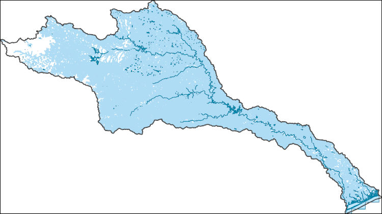
The National Hydrography Dataset (NHD) is a feature-based database that interconnects and uniquely identifies the stream segments or reaches that make up the nation's surface water drainage system. NHD data was originally developed at 1:100,000-scale and exists at that scale for the whole country. This high-resolution NHD, generally developed at 1:24,000/1:12,000 scale, adds detail to the original 1:100,000-scale NHD. (Data for Alaska, Puerto Rico and the Virgin Islands was developed at high-resolution, not 1:100,000 scale.) Local resolution NHD is being developed where partners and data exist. The NHD contains reach codes for networked features, flow direction, names, and centerline representations for areal water...
Tags: Administrative watershed units,
Administrative watershed units,
Area of Complex Channels,
Area to be submerged,
Austin, All tags...
Basin,
Basin,
Bastrop,
Bay/Inlet,
Blanco,
Boundaries,
Boundary,
Brazoria,
Bridge,
Brown,
Burnet,
Caldwell,
Callahan,
Canal/Ditch,
Coastline,
Coke,
Coleman,
Colorado,
Comanche,
Concho,
Connector,
Crockett,
Dam/Weir,
Downloadable Data,
Drainage areas for surface water,
Drainageway,
Eastland,
Edwards,
Estuary,
Fayette,
Flow direction network,
Flume,
ForeShore,
Fort Bend,
Gaging Station,
Gate,
GeoPackage,
Gillespie,
Glasscock,
HU-4,
HU-4 Subregion,
HU10,
HU12,
HU14,
HU16,
HU2,
HU4,
HU4_1209,
HU6,
HU8,
HUC,
Hays,
Hazard Zone,
Howard,
Hydrographic,
Hydrography,
Hydrography,
Hydrography,
Hydrologic Unit Code,
Hydrologic Units,
Ice mass,
Inundation Area,
Irion,
Kendall,
Kerr,
Kimble,
Lampasas,
Lee,
Levee,
Line,
Llano,
Lock Chamber,
Marsh,
Mason,
Matagorda,
McCulloch,
Menard,
Midland,
Mills,
National Hydrography Dataset (NHD),
National Hydrography Dataset (NHD) Best Resolution,
National Hydrography Dataset (NHD) Best Resolution,
Nolan,
Nonearthen Shore,
Open Geospatial Consortium GeoPackage 1.2,
Orthoimage,
Playa,
Point,
PointEvent,
Pond,
Rapids,
Rapids,
Reach,
Reach code,
Reagan,
Real,
Reef,
Region,
Reservoir,
Rock,
Runnels,
San Saba,
Schleicher,
Sea/Ocean,
Sink/Rise,
Sounding Datum Line,
Special Use Zone,
Special Use Zone Limit,
Spillway,
Sterling,
Stream,
Stream/River,
Sub-basin,
Sub-region,
Subbasin,
Submerged Stream,
Subregion,
Subwatershed,
Surface water systems,
Sutton,
Swamp,
TX,
Taylor,
Texas,
Tom Green,
Topographic,
Travis,
Tunnel,
US,
Underground Conduit,
United States,
Upton,
WBD,
WBD,
Wall,
Wash,
Washington,
Water Intake Outflow,
Waterfall,
Watershed,
Watershed Boundaries,
Watershed Boundary Dataset,
Watershed Boundary Dataset,
Well,
Wharton,
Williamson,
artificial path,
boundaries,
dams,
drainage systems and characteristics,
inlandWaters,
lakes,
ngda,
rivers, Fewer tags
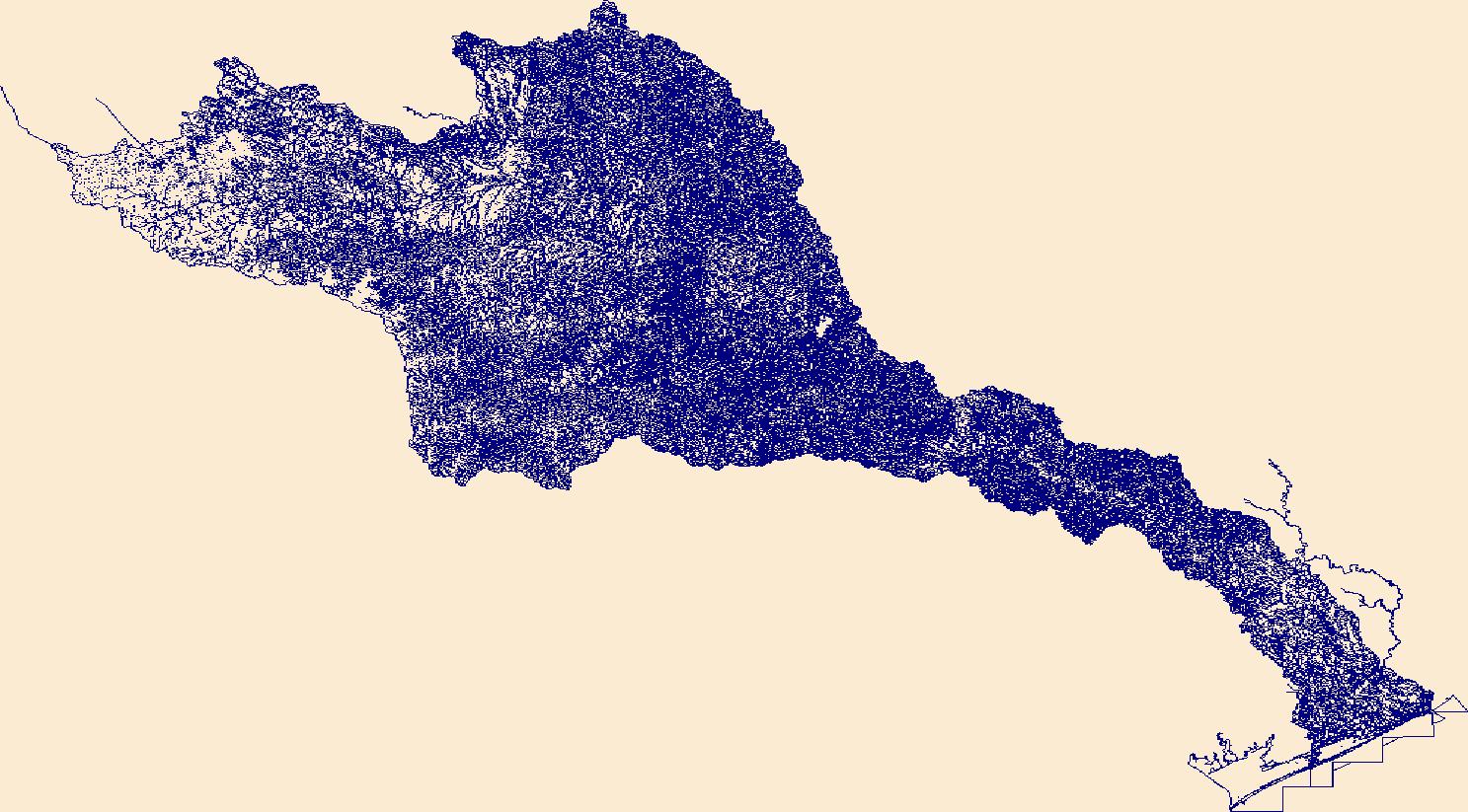
The High Resolution National Hydrography Dataset Plus (NHDPlus HR) is an integrated set of geospatial data layers, including the best available National Hydrography Dataset (NHD), the 10-meter 3D Elevation Program Digital Elevation Model (3DEP DEM), and the National Watershed Boundary Dataset (WBD). The NHDPlus HR combines the NHD, 3DEP DEMs, and WBD to create a stream network with linear referencing, feature naming, "value added attributes" (VAAs), elevation-derived catchments, and other features for hydrologic data analysis. The stream network with linear referencing is a system of data relationships applied to hydrographic systems so that one stream reach "flows" into another and "events" can be tied to and traced...
Tags: Austin County,
Bastrop County,
Blanco County,
Brazoria County,
Brown County, All tags...
Burnet County,
Caldwell County,
Callahan County,
Coke County,
Coleman County,
Colorado County,
Comanche County,
Concho County,
Crockett County,
Downloadable Data,
Eastland County,
Edwards County,
Fayette County,
FileGDB,
FileGDB 10.1,
Fort Bend County,
Gillespie County,
Glasscock County,
HU-4 Subregion,
HU-4 Subregion,
HU4_1209,
Hays County,
Howard County,
Hydrography,
Irion County,
Kendall County,
Kerr County,
Kimble County,
Lampasas County,
Lee County,
Llano County,
Mason County,
Matagorda County,
McCulloch County,
Menard County,
Midland County,
Mills County,
NHDPlus HR Rasters,
NHDPlus High Resolution (NHDPlus HR),
National Hydrography Dataset (NHD),
National Hydrography Dataset Plus High Resolution (NHDPlus HR),
National Hydrography Dataset Plus High Resolution (NHDPlus HR) Current,
Nolan County,
Reagan County,
Real County,
Runnels County,
San Saba County,
Schleicher County,
Sterling County,
Sutton County,
TX,
Taylor County,
Texas,
Tom Green County,
Travis County,
US,
United States,
Upton County,
Washington County,
Wharton County,
Williamson County,
base maps,
cartography,
catchments,
channels,
digital elevation models,
drainage basins,
earth sciences,
elevation,
environment,
geographic information systems,
geoscientific,
geospatial analysis,
hydrographic datasets,
hydrographic features,
hydrology,
imagery,
inland waters,
lakes,
land surface characteristics,
reservoirs,
river reaches,
rivers,
streamflow,
streamflow data,
streams,
topography,
water bodies,
water quality,
water resources,
watersheds, Fewer tags

The National Hydrography Dataset (NHD) is a feature-based database that interconnects and uniquely identifies the stream segments or reaches that make up the nation's surface water drainage system. NHD data was originally developed at 1:100,000-scale and exists at that scale for the whole country. This high-resolution NHD, generally developed at 1:24,000/1:12,000 scale, adds detail to the original 1:100,000-scale NHD. (Data for Alaska, Puerto Rico and the Virgin Islands was developed at high-resolution, not 1:100,000 scale.) Local resolution NHD is being developed where partners and data exist. The NHD contains reach codes for networked features, flow direction, names, and centerline representations for areal water...
Tags: Administrative watershed units,
Administrative watershed units,
Area of Complex Channels,
Area to be submerged,
Austin, All tags...
Basin,
Basin,
Bastrop,
Bay/Inlet,
Blanco,
Boundaries,
Boundary,
Brazoria,
Bridge,
Brown,
Burnet,
Caldwell,
Callahan,
Canal/Ditch,
Coastline,
Coke,
Coleman,
Colorado,
Comanche,
Concho,
Connector,
Crockett,
Dam/Weir,
Downloadable Data,
Drainage areas for surface water,
Drainageway,
Eastland,
Edwards,
Esri Shapefile nan,
Estuary,
Fayette,
Flow direction network,
Flume,
ForeShore,
Fort Bend,
Gaging Station,
Gate,
Gillespie,
Glasscock,
HU-4,
HU-4 Subregion,
HU10,
HU12,
HU14,
HU16,
HU2,
HU4,
HU4_1209,
HU6,
HU8,
HUC,
Hays,
Hazard Zone,
Howard,
Hydrographic,
Hydrography,
Hydrography,
Hydrography,
Hydrologic Unit Code,
Hydrologic Units,
Ice mass,
Inundation Area,
Irion,
Kendall,
Kerr,
Kimble,
Lampasas,
Lee,
Levee,
Line,
Llano,
Lock Chamber,
Marsh,
Mason,
Matagorda,
McCulloch,
Menard,
Midland,
Mills,
National Hydrography Dataset (NHD),
National Hydrography Dataset (NHD) Best Resolution,
National Hydrography Dataset (NHD) Best Resolution,
Nolan,
Nonearthen Shore,
Orthoimage,
Playa,
Point,
PointEvent,
Pond,
Rapids,
Rapids,
Reach,
Reach code,
Reagan,
Real,
Reef,
Region,
Reservoir,
Rock,
Runnels,
San Saba,
Schleicher,
Sea/Ocean,
Shapefile,
Sink/Rise,
Sounding Datum Line,
Special Use Zone,
Special Use Zone Limit,
Spillway,
Sterling,
Stream,
Stream/River,
Sub-basin,
Sub-region,
Subbasin,
Submerged Stream,
Subregion,
Subwatershed,
Surface water systems,
Sutton,
Swamp,
TX,
Taylor,
Texas,
Tom Green,
Topographic,
Travis,
Tunnel,
US,
Underground Conduit,
United States,
Upton,
WBD,
WBD,
Wall,
Wash,
Washington,
Water Intake Outflow,
Waterfall,
Watershed,
Watershed Boundaries,
Watershed Boundary Dataset,
Watershed Boundary Dataset,
Well,
Wharton,
Williamson,
artificial path,
boundaries,
dams,
drainage systems and characteristics,
inlandWaters,
lakes,
ngda,
rivers, Fewer tags
The National Hydrography Dataset (NHD) is a feature-based database that interconnects and uniquely identifies the stream segments or reaches that make up the nation's surface water drainage system. NHD data was originally developed at 1:100,000-scale and exists at that scale for the whole country. This high-resolution NHD, generally developed at 1:24,000/1:12,000 scale, adds detail to the original 1:100,000-scale NHD. (Data for Alaska, Puerto Rico and the Virgin Islands was developed at high-resolution, not 1:100,000 scale.) Local resolution NHD is being developed where partners and data exist. The NHD contains reach codes for networked features, flow direction, names, and centerline representations for areal water...
Tags: Administrative watershed units,
Administrative watershed units,
Area of Complex Channels,
Area to be submerged,
Austin, All tags...
Basin,
Basin,
Bastrop,
Bay/Inlet,
Blanco,
Boundaries,
Boundary,
Brazoria,
Bridge,
Brown,
Burnet,
Caldwell,
Callahan,
Canal/Ditch,
Coastline,
Coke,
Coleman,
Colorado,
Comanche,
Concho,
Connector,
Crockett,
Dam/Weir,
Downloadable Data,
Drainage areas for surface water,
Drainageway,
Eastland,
Edwards,
Esri File GeoDatabase 10,
Estuary,
Fayette,
FileGDB,
Flow direction network,
Flume,
ForeShore,
Fort Bend,
Gaging Station,
Gate,
Gillespie,
Glasscock,
HU-4,
HU-4 Subregion,
HU10,
HU12,
HU14,
HU16,
HU2,
HU4,
HU4_1209,
HU6,
HU8,
HUC,
Hays,
Hazard Zone,
Howard,
Hydrographic,
Hydrography,
Hydrography,
Hydrography,
Hydrologic Unit Code,
Hydrologic Units,
Ice mass,
Inundation Area,
Irion,
Kendall,
Kerr,
Kimble,
Lampasas,
Lee,
Levee,
Line,
Llano,
Lock Chamber,
Marsh,
Mason,
Matagorda,
McCulloch,
Menard,
Midland,
Mills,
National Hydrography Dataset (NHD),
National Hydrography Dataset (NHD) Best Resolution,
National Hydrography Dataset (NHD) Best Resolution,
Nolan,
Nonearthen Shore,
Orthoimage,
Playa,
Point,
PointEvent,
Pond,
Rapids,
Rapids,
Reach,
Reach code,
Reagan,
Real,
Reef,
Region,
Reservoir,
Rock,
Runnels,
San Saba,
Schleicher,
Sea/Ocean,
Sink/Rise,
Sounding Datum Line,
Special Use Zone,
Special Use Zone Limit,
Spillway,
Sterling,
Stream,
Stream/River,
Sub-basin,
Sub-region,
Subbasin,
Submerged Stream,
Subregion,
Subwatershed,
Surface water systems,
Sutton,
Swamp,
TX,
Taylor,
Texas,
Tom Green,
Topographic,
Travis,
Tunnel,
US,
Underground Conduit,
United States,
Upton,
WBD,
WBD,
Wall,
Wash,
Washington,
Water Intake Outflow,
Waterfall,
Watershed,
Watershed Boundaries,
Watershed Boundary Dataset,
Watershed Boundary Dataset,
Well,
Wharton,
Williamson,
artificial path,
boundaries,
dams,
drainage systems and characteristics,
inlandWaters,
lakes,
ngda,
rivers, Fewer tags
|
|

