Filters: Tags: Highways (X)
36 results (89ms)|
Filters
|
A layer of the genereal location of rest areas and information centers known by WyDOT within the state of Wyoming
Categories: Data;
Types: Downloadable;
Tags: Highways,
Information Center,
Rest Area,
Tourism,
Wyoming,
A polygon dataset of current road footprints in the SNK REA derived from the Alaska Department of Natural Resources infrastructure data (see the process steps for details). (This data depicts infrastructure locations in Alaska as digitized primarily from 1:24,000, 1:63,360, and 1:250,000 USGS quadrangles. The source document that represented the newest information and best geographic location was used to capture the data. All infrastructure from the primary source document was digitized and then supplemented with the information from other source documents for additional or updated infrastructure or attributes.)
This web map contains the ESRI ArcGIS Online World Topographic Map service, (aka "the community basemap"). The World Topographic Map service is designed to be used as a basemap by GIS professionals and as a reference map by anyone. The service includes administrative boundaries, cities, water features, physiographic features, parks, landmarks, highways, roads, railways, airports, and buildings overlaid on land cover and s
Categories: Data;
Types: ArcGIS REST Map Service,
Map Service;
Tags: Administrative Area,
Airports,
Buildings,
Cities,
Highways,
All Interstates in the western United States from the 2000 US Census TIGER/line files.
Categories: Data;
Types: Downloadable,
Map Service,
OGC WFS Layer,
OGC WMS Layer,
Shapefile;
Tags: Arizona,
California,
Census 2000,
Colorado,
Idaho,
This basedata service provides a cached service for users of Wyoming geospatial data using ESRI GIS. The service provides basedata for: Roads, Waterbodies, Rivers/Streams, Cities and County Boundaries. USE CONSTRAINTS: Users should follow use constraints found for each data layer available in the mapping service. Visit the Wyoming GeoLibrary for original metadata. WYGISC DOES NOT GUARANTEE 24/7 SUPPORT OF ITS UNFUNDED, FREE MAPPING SERVICES. WyGISC reserves the right to remove access to these services at any time.
This data depicts infrastructure locations in Alaska as digitized primarily from 1:24,000, 1:63,360, and 1:250,000 USGS quadrangles. The source document that represented the newest information and best geographic location was used to capture the data. All infrastructure from the primary source document was digitized and then supplemented with the information from other source documents for additional or updated infrastructure or attributes.
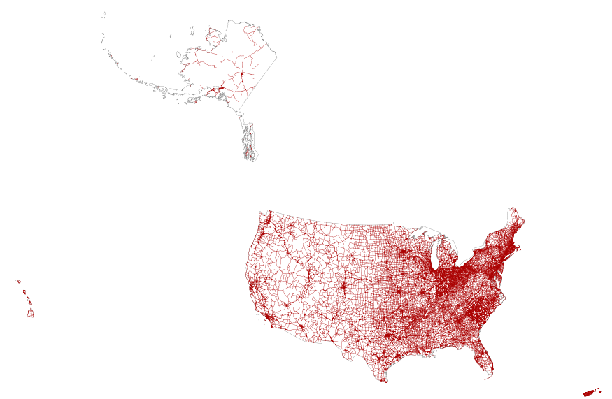
This map layer portrays the major roads in the United States, Puerto Rico, and the U.S. Virgin Islands. The file was produced by joining the individual State roads layers from the National Highway Planning Network (NHPN), Geographic Data Technology (GDT) Dynamap, and TIGER/Line files. This is a revised version of the July 2012 map layer.
Density (km / km^2) of all roads in the western United States. Dataset was developed to generalize the 2000 US Census TIGER/Line Roads layer to a density within 18km of each pixel. Obtained from 2000 US Census TIGER/Line Roads using LINEDENSITY with an 18km search radius.
Categories: Data;
Types: Downloadable,
GeoTIFF,
Map Service,
Raster;
Tags: Arizona,
California,
Census 2000,
Colorado,
Idaho,
The National Highway Planning Network is a comprehensive network database of the nation's major highway system. It consists of the nation's highways comprised of Rural Arterials, Urban Principal Arterials and all National Highway System routes. The data set covers the States of Arizona, California, Colorado, Idaho, Montana, Nevada, New Mexico, Oregon, Utah, Washington, and Wyoming . The nominal scale of the data set is 1:100,000 with a maximal positional error of ±80 meters.

This dataset is clipped to the Tehachapi Study Area. U.S. and Canada Detailed Streets represents streets, highways, roads with and without limited access, secondary and connecting roads, local and rural roads, roads with special characteristics, access ramps, and ferries within the United States and Canada. This data set contains road network features such as arterial classification, speed, and direction of travel. It contains address ranges for all addressable features with addresses.
Synopsis: This paper summarizes significant findings from literature related to the effect of noise on wildlife, emphasizing the effects of road traffic noise on birds. Many studies from the United States and the Netherlands indicate that road noise has a negative effect on bird populations, particularly during breeding season in a variety of species. In this paper, ‘effect distances’—distances at which bird density decreases—are reported at a range of two to three thousand meters from the road. Effect distances tend to increase with traffic density, being the greatest near large, multilane highways. In a study of woodland species, 26 of 43 (60%) were found to show a decrease in population densities with effect...
Categories: Publication;
Types: Citation,
Map Service,
OGC WFS Layer,
OGC WMS Layer,
OGC WMS Service;
Tags: Land use configuration,
Landscape fragmentation,
MA USA,
Netherlands and Boston,
edge effects,

This map service and the attached file geodatabase represent OpenStreetMap (OSM) road data clipped to the NPLCC (North Pacific  Landscape Conservation Cooperative) geography. The data were obtained from WeoGeo, which converts OSM data from its native format to Esri formats (and others).  They last updated their database on Jan 1st, 2014. "OpenStreetMap is dedicated to created and providing geographic data, such as street maps, worldwide, for free. Most maps considered "free" actually have legal or technical restrictions on their use. These restrictions hold back anyone from using them in creative, productive or unexpected ways, and make every map a silo of data and effort. OSM's open license gives users the...

U.S. and Canada Detailed Streets represents streets, highways, roads with and without limited access, secondary and connecting roads, local and rural roads, roads with special characteristics, access ramps, and ferries within the United States and Canada. This data set contains road network features such as arterial classification, speed, and direction of travel. It contains address ranges for all addressable features with addresses.
This data depicts infrastructure locations in Alaska as digitized primarily from 1:24,000, 1:63,360, and 1:250,000 USGS quadrangles. The source document that represented the newest information and best geographic location was used to capture the data. All infrastructure from the primary source document was digitized and then supplemented with the information from other source documents for additional or updated infrastructure or attributes. In addition, ISER added major rivers (those being named in the Anadromous streams catalog and > 150 km in length) and the historic Iditarod Trails for additional reference.
This data depicts infrastructure locations in Alaska as digitized primarily from 1:24,000, 1:63,360, and 1:250,000 USGS quadrangles. The source document that represented the newest information and best geographic location was used to capture the data. All infrastructure from the primary source document was digitized and then supplemented with the information from other source documents for additional or updated infrastructure or attributes. In addition, ISER added major rivers (those being named in the Anadromous streams catalog and > 150 km in length) and the historic Iditarod Trails for additional reference.
A dataset comprised of road centerlines in Wyoming, USA, digitized to 2015 aerial photography from the National Agriculture Imagery Program. This dataset is an update to a former U.S. Geological Survey Data Series (“Large scale Wyoming transportation data: a resource planning tool”: O'Donnell and others, 2014) digitized to 2009 aerial photography. The U.S. Geological Survey Fort Collins Science Center created statewide roads data for the Bureau of Land Management Wyoming State Office using 2015 aerial photography from the National Agriculture Imagery Program. To ensure a systematic and repeatable approach of capturing roads on the landscape using on-screen digitizing from true color National Agriculture Imagery...
A polygon dataset of current landing strip and airport footprints in the SNK REA - derived from the Alaska Department of Natural Resources infrastructure data (see the process steps for details).(This data depicts infrastructure locations in Alaska as digitized primarily from 1:24,000, 1:63,360, and 1:250,000 USGS quadrangles. The source document that represented the newest information and best geographic location was used to capture the data. All infrastructure from the primary source document was digitized and then supplemented with the information from other source documents for additional or updated) infrastructure or attributes.
This layer represents the major road network of the U.S. Northern Rockies. It was created by merging Montana Department of Transportation "on-system" routes with Idaho Transportation Department "state highway system" routes, creating consistent attribute fields, then clipping to the U.S. Northern Rockies study area boundary.
Categories: Data;
Types: ArcGIS REST Map Service,
ArcGIS Service Definition,
Downloadable,
Map Service,
OGC WFS Layer,
OGC WMS Layer,
OGC WMS Service,
Shapefile;
Tags: Data,
EARTH SCIENCE > LAND SURFACE > LANDSCAPE,
Highways,
Highways,
Idaho,
Major roads in northern North America as determined by the U.S. National Atlas and The National Atlas of Canada (geogratis.cgdi.gc.ca). National data layers were re-attributed and merged to create a seamless major road layer for North America.

This service contains data for Interstates, Highways and Major Roads (data obtained from USGS) and BLM roads.
|

|
