Filters: Tags: Hydrological (X)
41 results (9ms)|
Filters
Date Range
Extensions Types Contacts
Categories Tag Types Tag Schemes |
This spatial dataset consists of 219 1-kilometer (km) resolution grids depicting estimated agricultural use of 219 pesticides in 1997 for the conterminous United States. Each grid cell value in the national grids of this dataset is the estimated total kilograms (kg) of a pesticide applied to row crops, small grain crops and fallow land, pasture and hay crops, and orchard and vineyard crops within the 1- by 1-km area. Nonagricultural uses of pesticides are not included in this dataset. Of the 219 pesticidesrepresented in the grids, 96 are herbicides, 65 are insecticides, and 37 are fungicides. The remaining 21 compounds are composed of the category "other pesticides", which consist of fumigants, growth regulators,...

This spatial data set was created by the U.S. Geological Survey (USGS) to represent the amount of nitrogen generated at confined cattle operations that was applied to nearby farm land in the Pacific Northwest region of the United States (Hydro Region 17; Major River Basin 7 (MRB7)) during 2002.
Many governments, firms, institutions and individuals have become increasingly cognizant of their impact on the environment, most notably with respect to global climate change. Coupled with the possibility of future regulations aimed at curbing greenhouse gas emissions, firms and institutions have begun to critically evaluate their own carbon footprint. This paper examines the preferences of stakeholders within a large academic institution for attributes of alternative greenhouse gas (GHG) reduction strategies. The attributes considered by constituents include: the fuel portfolio mix, effort for conserving energy use, carbon emissions reduction, timeframe for emissions reduction to be achieved and cost. We use a...
Categories: Publication;
Types: Citation;
Tags: Valuing,
forecasts,
hydrological,
hydropower,
pumped storage
The CAGES program (Comparative Assessment of Gulf Estuarine Systems) is designed to examine the differences between estuarine ecosystems and investigate why some are more productive than others. The program focuses on estuarine areas important to commercial fisheries and includes data on commercial finfish and invertebrate species, as well as other species commonly captured in trawl sampling. This Louisiana dataset is a subset of the CAGES Relational Database which is a compilation of fishery-independent data contributed by natural resource agencies of the Gulf States (Texas, Louisiana, Mississippi, Alabama, and Florida). This data set includes data from trawls collected by the Alabama Department of Conservation...
Categories: Data;
Tags: Alabama,
Alabama Department of Conservation and Natural Resources,
Annelida,
Arnica Bay,
Bay Minette Creek,
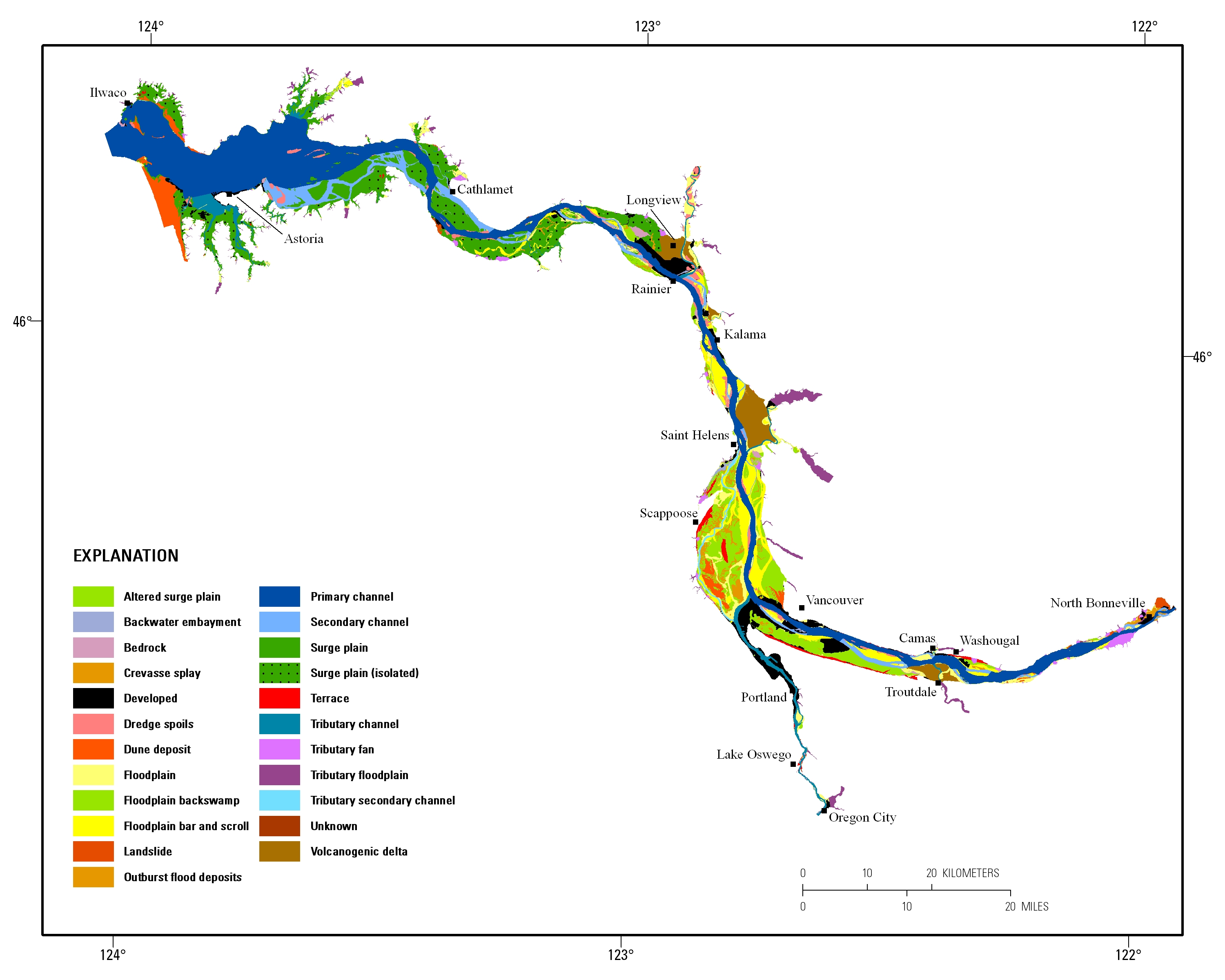
Estuarine ecosystems are controlled by a variety of processes that operate at multiple spatial and temporal scales. Understanding the hierarchical nature of these processes will aid in prioritization of restoration efforts. This hierarchical Columbia River Estuary Ecosystem Classification (henceforth "Classification") of the Columbia River estuary is a spatial database of the tidally-influenced reaches of the lower Columbia River, the tidally affected parts of its tributaries, and the landforms that make up their floodplains for the 230 kilometers between the Pacific Ocean and Bonneville Dam. This work is a collaborative effort between University of Washington School of Aquatic and Fishery Sciences (henceforth "UW"),...
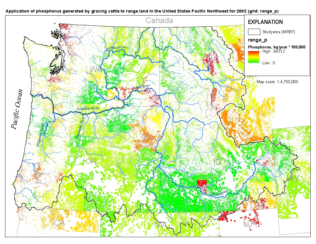
This spatial data set was created by the U.S. Geological Survey (USGS) to represent the amount of phosphorus generated by grazing cattle that was applied to range land in the Pacific Northwest region of the United States (Hydro Region 17; Major River Basin 7 (MRB7)) during 2002.
Many governments, firms, institutions and individuals have become increasingly cognizant of their impact on the environment, most notably with respect to global climate change. Coupled with the possibility of future regulations aimed at curbing greenhouse gas emissions, firms and institutions have begun to critically evaluate their own carbon footprint. This paper examines the preferences of stakeholders within a large academic institution for attributes of alternative greenhouse gas (GHG) reduction strategies. The attributes considered by constituents include: the fuel portfolio mix, effort for conserving energy use, carbon emissions reduction, timeframe for emissions reduction to be achieved and cost. We use a...
Categories: Publication;
Types: Citation;
Tags: Valuing,
forecasts,
hydrological,
hydropower,
pumped storage
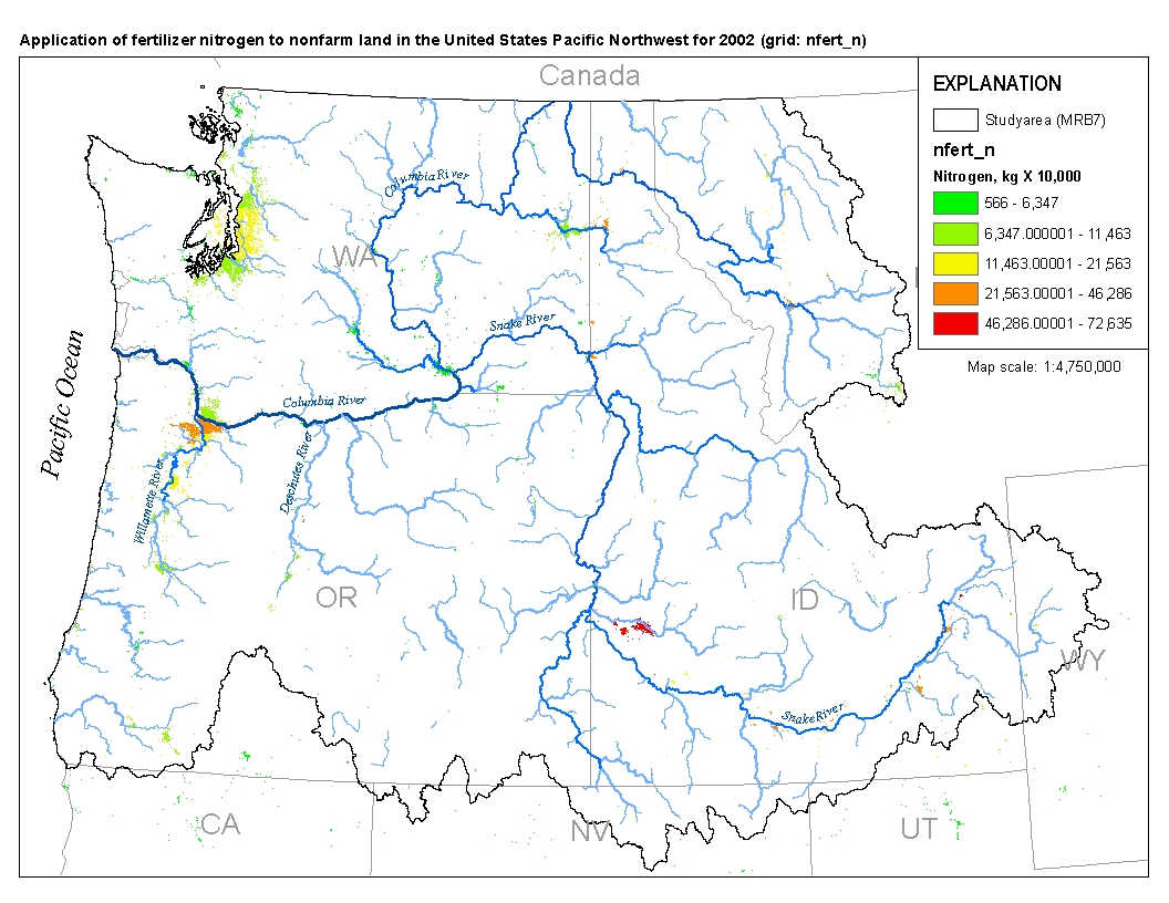
This spatial data set was created by the U.S. Geological Survey (USGS) to represent the amount of fertilizer nitrogen that was applied to nonfarm land in the Pacific Northwest region of the United States (Hydro Region 17; Major River Basin 7 (MRB7)) during 2002.
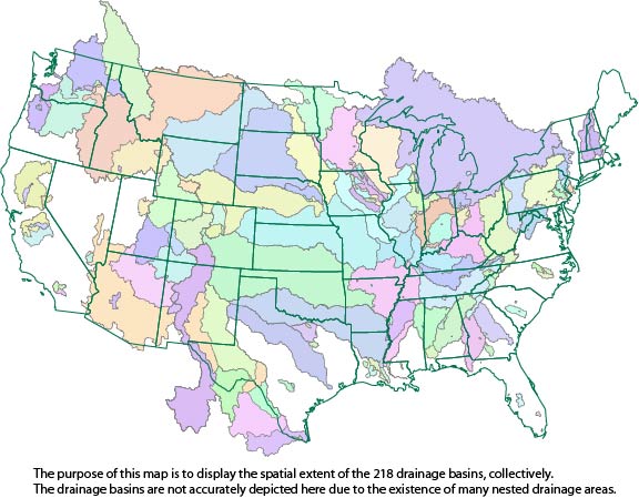
This dataset consists of drainage basin boundaries for 212 U.S. Geological Survey (USGS) stream sites sampled in the National Water-Quality Assessment (NAWQA) Program, the National Stream Quality Accounting Network (NASQAN), and the National Monitoring Network (NMN). Of the 212 sites, 206 have either a contributing or total drainage basin boundary, and the remaining 6 have both a total drainage basin boundary and a smaller contributing basin boundary. Collectively, these 218 basin boundaries have been used in a geographic information system (GIS) to generate basin characteristics for the assessment of trends in concentrations of pesticides streams of the United States.
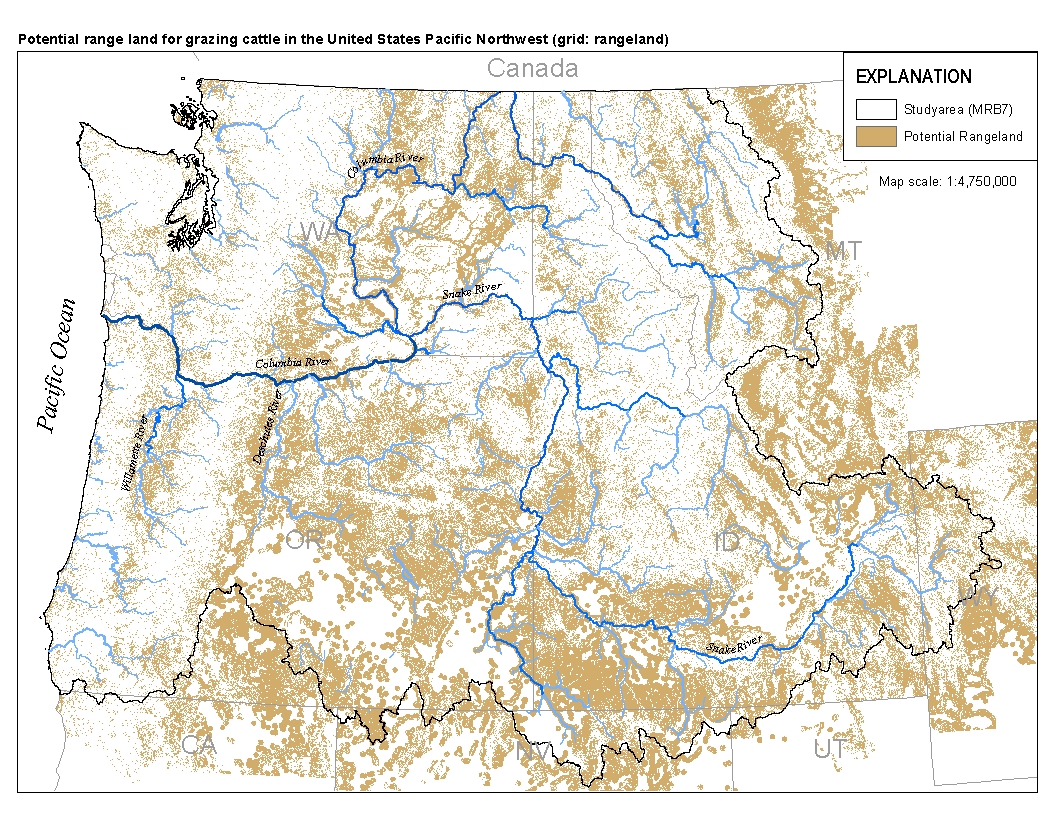
This spatial data set was created by the U.S. Geological Survey (USGS) to represent the extent of land in the Pacific Northwest region of the United States (Hydro Region 17; Major River Basin 7 (MRB7)) that potentially received waste from grazing cattle in 2002.
In this paper we review threshold behaviour in environmental systems, which are often associated with the onset of floods, contamination and erosion events, and other degenerative processes. Key objectives of this review are to a) suggest indicators for detecting threshold behavior, b) discuss their implications for predictability, c) distinguish different forms of threshold behavior and their underlying controls, and d) hypothesise on possible reasons for why threshold behaviour might occur. Threshold behaviour involves a fast qualitative change of either a single process or the response of a system. For elementary phenomena this switch occurs when boundary conditions (e.g., energy inputs) or system states as expressed...
Categories: Publication;
Types: Citation;
Tags: Threshold,
behaviour,
controls,
geo-ecosystems,
human,
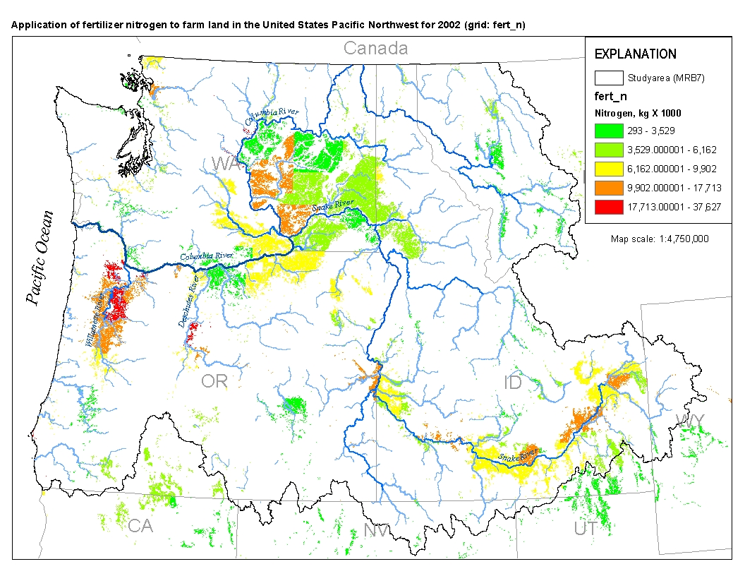
This spatial data set was created by the U.S. Geological Survey (USGS) to represent the amount of fertilizer nitrogen that was applied to farm land in the Pacific Northwest region of the United States (Hydro Region 17; Major River Basin 7 (MRB7)) during 2002.
Estuarine ecosystems are controlled by a variety of processes that operate at multiple spatial and temporal scales. Understanding the hierarchical nature of these processes will aid in prioritization of restoration efforts. This hierarchical Columbia River Estuary Ecosystem Classification (henceforth "Classification") of the Columbia River estuary is a spatial database of the tidally-influenced reaches of the lower Columbia River, the tidally affected parts of its tributaries, and the landforms that make up their floodplains for the 230 kilometers between the Pacific Ocean and Bonneville Dam. This work is a collaborative effort between University of Washington School of Aquatic and Fishery Sciences (henceforth "UW"),...
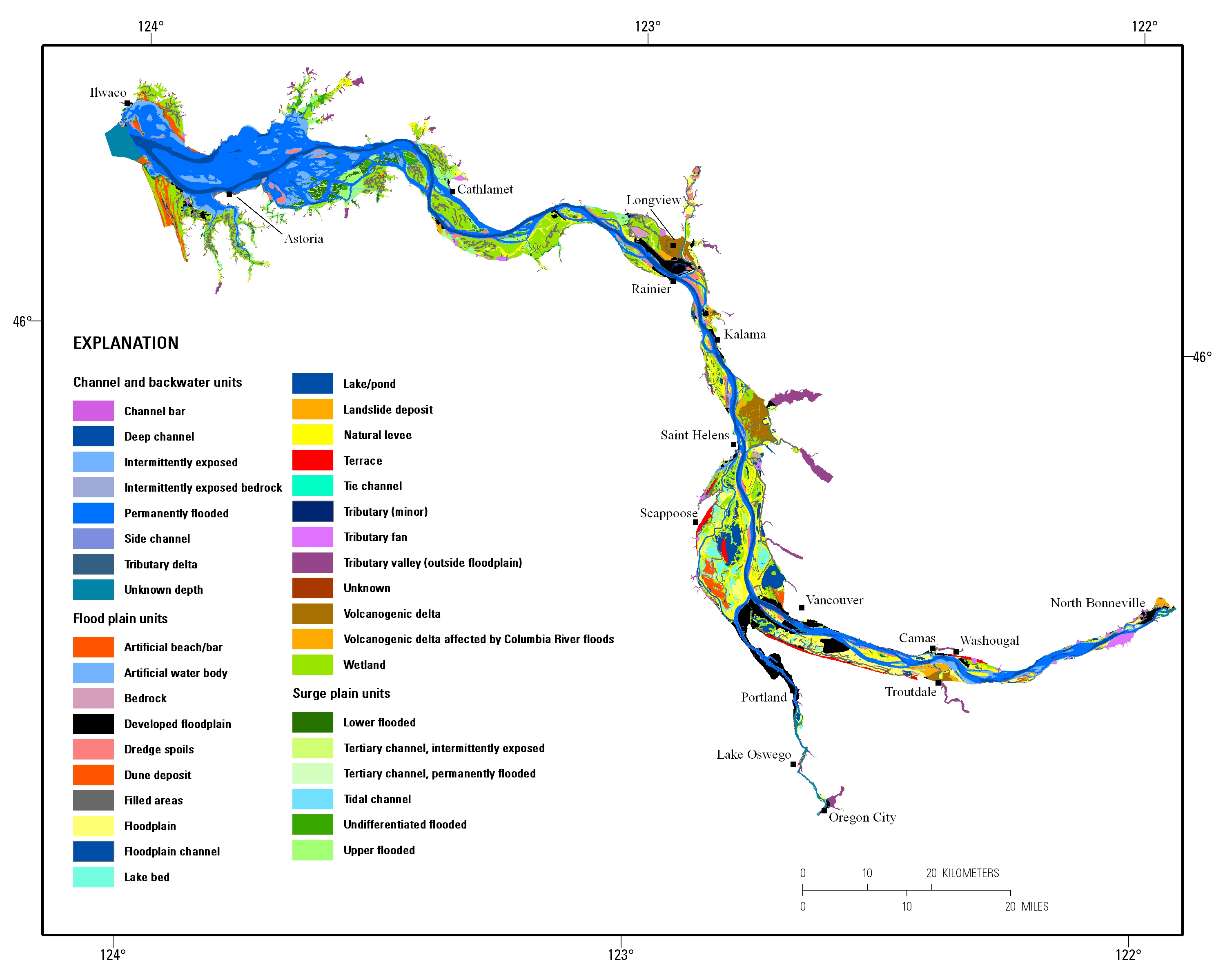
Estuarine ecosystems are controlled by a variety of processes that operate at multiple spatial and temporal scales. Understanding the hierarchical nature of these processes will aid in prioritization of restoration efforts. This hierarchical Columbia River Estuary Ecosystem Classification (henceforth "Classification") of the Columbia River estuary is a spatial database of the tidally-influenced reaches of the lower Columbia River, the tidally affected parts of its tributaries, and the landforms that make up their floodplains for the 230 kilometers between the Pacific Ocean and Bonneville Dam. This work is a collaborative effort between University of Washington School of Aquatic and Fishery Sciences (henceforth "UW"),...
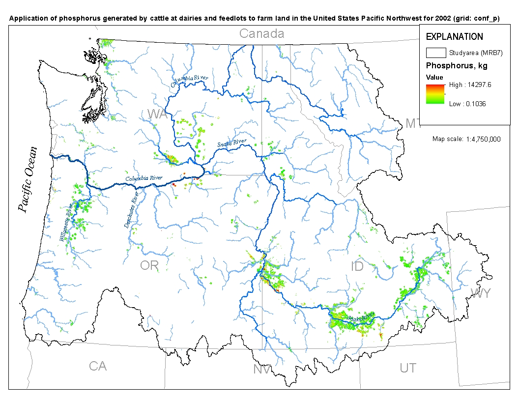
This spatial data set was created by the U.S. Geological Survey (USGS) to represent the amount of phosphorus generated at confined cattle operations that was applied to nearby farm land in the Pacific Northwest region of the United States (Hydro Region 17; Major River Basin 7 (MRB7)) during 2002.
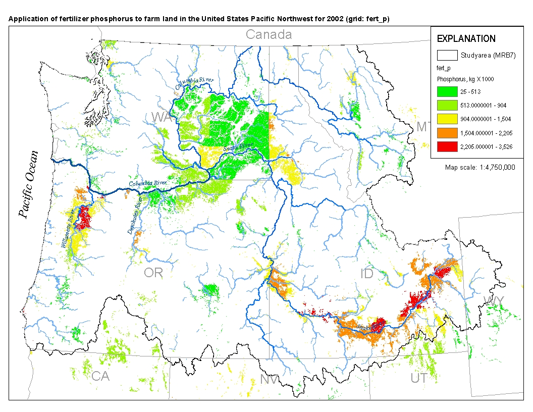
This spatial data set was created by the U.S. Geological Survey (USGS) to represent the amount of fertilizer phosphorus that was applied to farm land in the Pacific Northwest region of the United States (Hydro Region 17; Major River Basin 7 (MRB7)) during 2002.
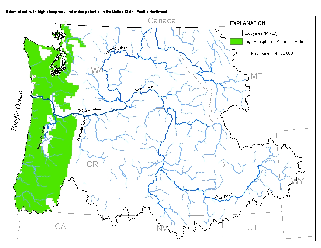
This spatial data set was created by the U.S. Geological Survey (USGS) to represent the extent of soils with high phosphorus retention potential in the Pacific Northwest region of the United States (Hydro Region 17; Major River Basin 7 (MRB7)).
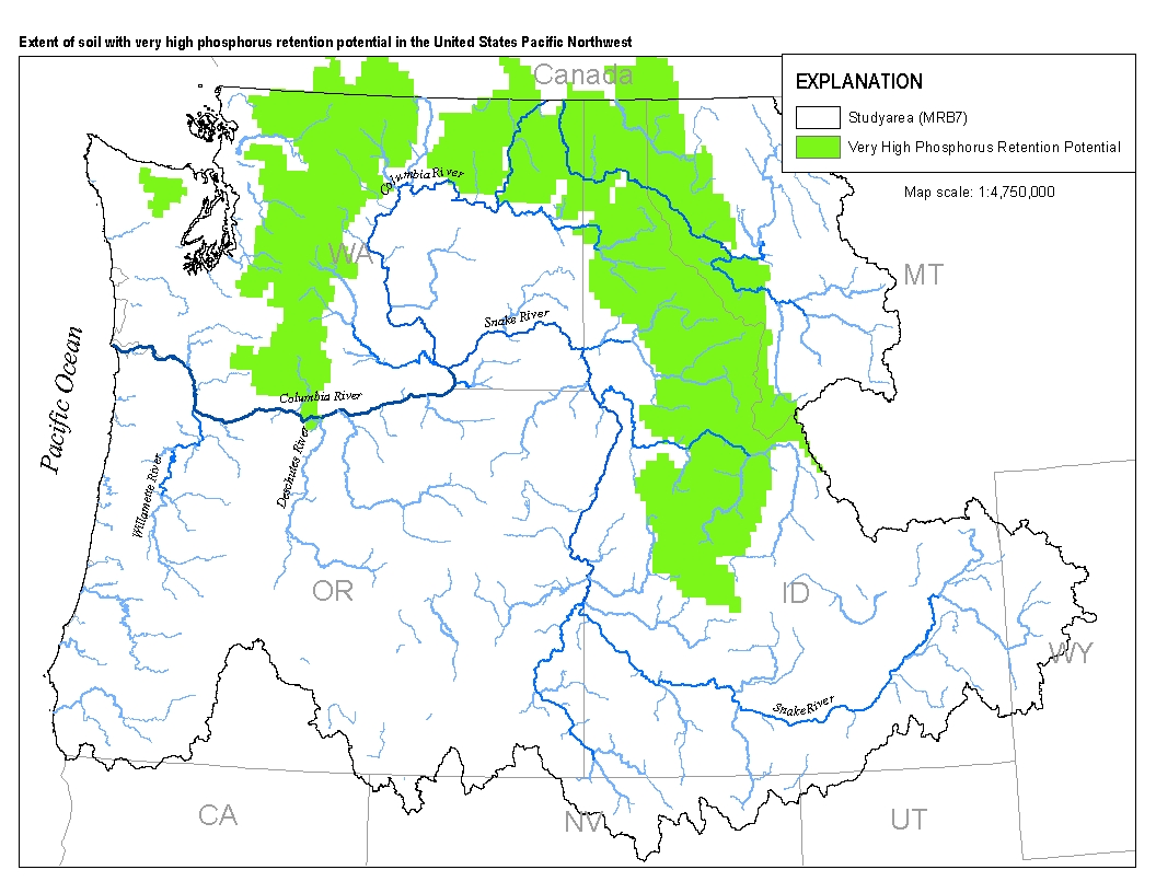
This spatial data set was created by the U.S. Geological Survey (USGS) to represent the extent of soils with very high levels of phosphorus retention potential in the Pacific Northwest region of the United States (Hydro Region 17; Major River Basin 7 (MRB7)).
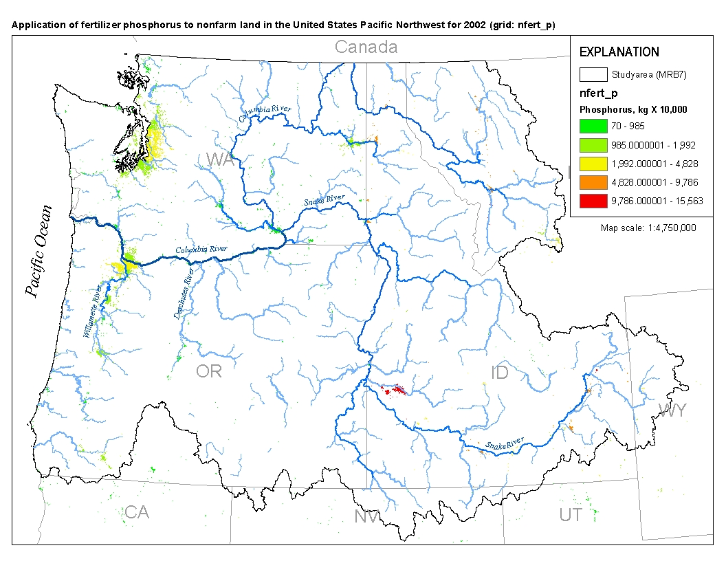
Application of fertilizer phosphorus to nonfarm land in the United States Pacific Northwest for 2002
This spatial data set was created by the U.S. Geological Survey (USGS) to represent the amount of fertilizer phosphorus that was applied to nonfarm land in the Pacific Northwest region of the United States (Hydro Region 17; Major River Basin 7 (MRB7)) during 2002.
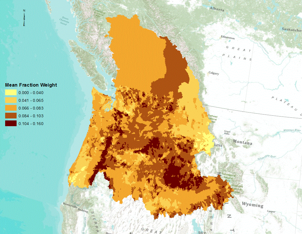
Phosphorus is a naturally occurring element found in all rocks; the amount varies by the type of rock. The amount of phosphorus in sediments is expected to be correlated with the amount of phosphorus in the parent rocks. Streambed sediment collected by the National Uranium Resource Evaluation (NURE) Program were used to estimate the variation of phosphorus across the Pacific Northwest. This file provides an estimate of the mean concentration of phosphorus in soils for each incremental catchment of the USGS Pacific Northwest SPARROW model.
|

|
