Filters: Tags: Hydrology (X) > Date Range: {"choice":"year"} (X)
1,243 results (149ms)|
Filters
Date Types (for Date Range)
Types
Contacts
Categories Tag Types
|
A monthly water-balance model (MWBM) is applied to simulate components of the water balance for the period 1950-2100 under ssp245, ssp370, and ssp585 scenarios for the Contiguous United States. The statistically downscaled LOCA2 temperature and precipitation projections from 27 GCMs from the Climate Model Intercomparison Program Phase 6 (CMIP6) are use as input to the water balance model. This data set supports the USGS National Climate Change Viewer (ver. 2). The statistically downscaled data set is: CMIP6-LOCA2: Localized Constructed Analogs (Pierce et al. 2023, bias corrected by a modified version of Livneh et al. 2013) Users interested in the downscaled temperature and precipitation files are referred to the...
In 2013, the U.S. Geological Survey (USGS) in partnership with the U.S. Federal Highway Administration (FHWA) published a new national stormwater quality model called the Stochastic Empirical Loading Dilution Model (SELDM; Granato, 2013). The model is optimized for roadway projects but in theory can be applied to a broad range of development types. SELDM is a statistically-based empirical model pre-populated with much of the data required to successfully run the application (Granato, 2013). The model uses Monte Carlo methods (as opposed to deterministic methods) to generate a wide range of precipitation events and stormwater discharges coupled with water-quality constituent concentrations and loads from the upstream...
Categories: Data;
Types: Map Service,
OGC WFS Layer,
OGC WMS Layer,
OGC WMS Service;
Tags: Best Management Practice (BMP),
Blue Ridge,
Coastal Plain,
Event Mean Concentration,
Federal Highway Administration,
Data were collected in the Sacramento River Deep Water Ship Channel (West Sacramento, CA) in support of a whole-ecosystem experiment investigating whether phytoplankton production and biomass would respond to nitrate additions, which could potentially be exported to food-limited regions in the Sacramento–San Joaquin Delta. The experiment was conducted from July 2 to September 18, 2019. Publications presenting ecosystem metabolism and hydrodynamic results from the experiment are under review, and a publication presenting the overall experiment results is in process. Continuous discharge and water quality data collected at USGS stations in the study area during the experiment are availble on NWISWeb: Site 5: https://waterdata.usgs.gov/nwis/inventory/?site_no=383114121350601&agen...
This data release documents the digital data used to produce flood-inundation maps for a range of gage heights (stages) for the Sabinal River near Utopia, Tex. The simulated flood-inundation maps correspond to a range in stage from 11 to 28 feet (ft) at U.S. Geological Survey (USGS) streamgage 08197970 Sabinal River at Utopia, Tex. at intervals of 0.5-ft. The maps were created for a 10-mile reach of the Sabinal River extending from USGS streamgage 08197936 Sabinal River below Mill Creek near Vanderpool, Tex. to USGS streamgage 08197970 Sabinal River at Utopia, Tex. (hereinafter referred to as the “Utopia gage”) and 7-mile reach of the West Sabinal River were created by the USGS in cooperation with the Bandera County...
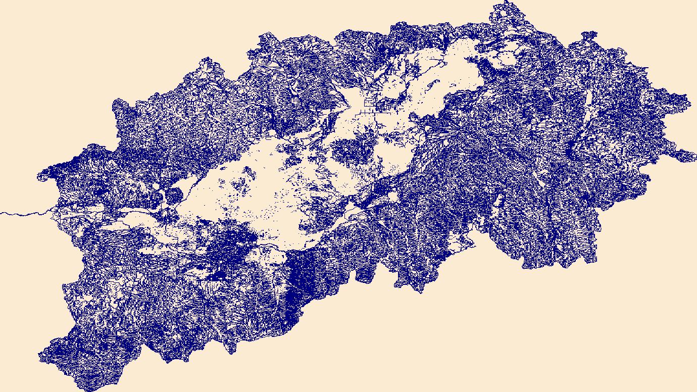
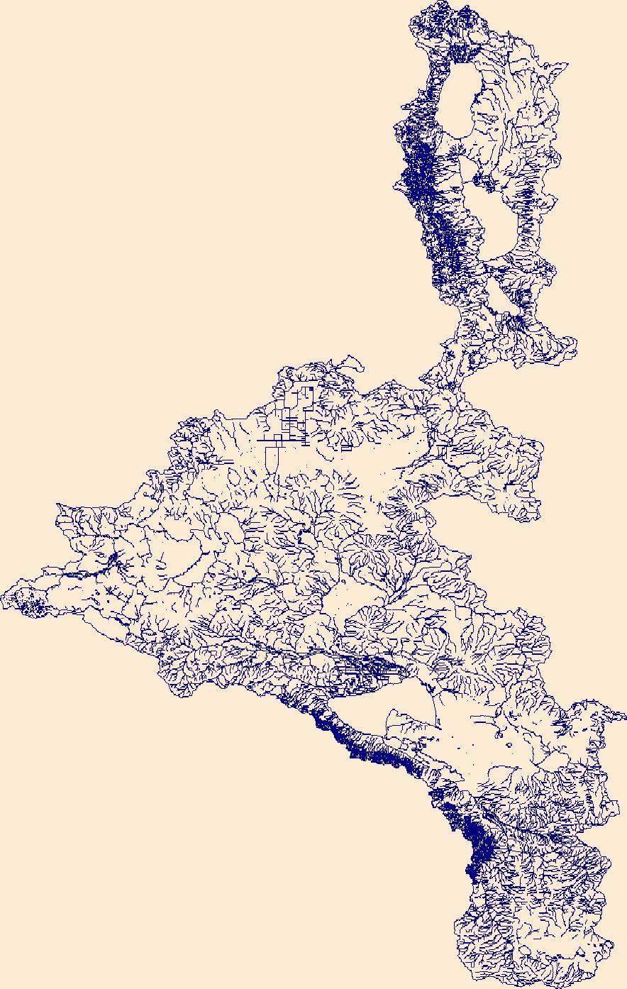
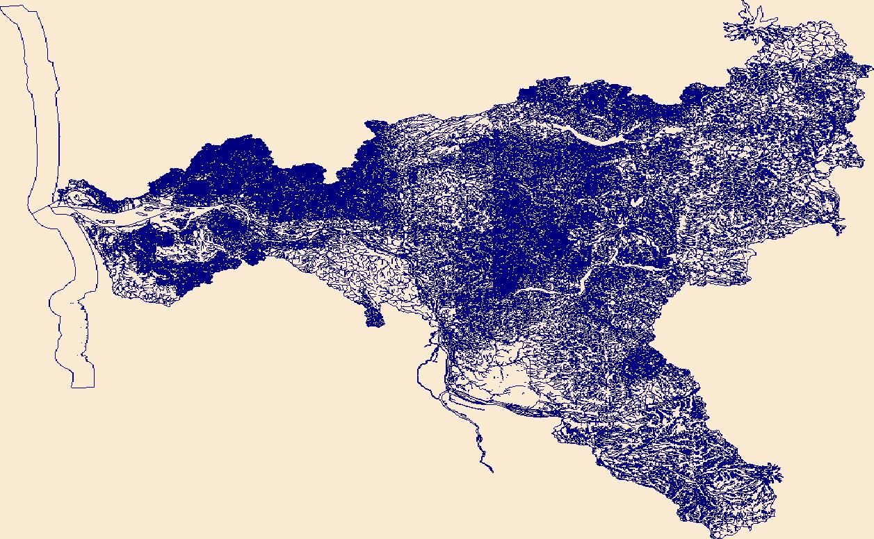
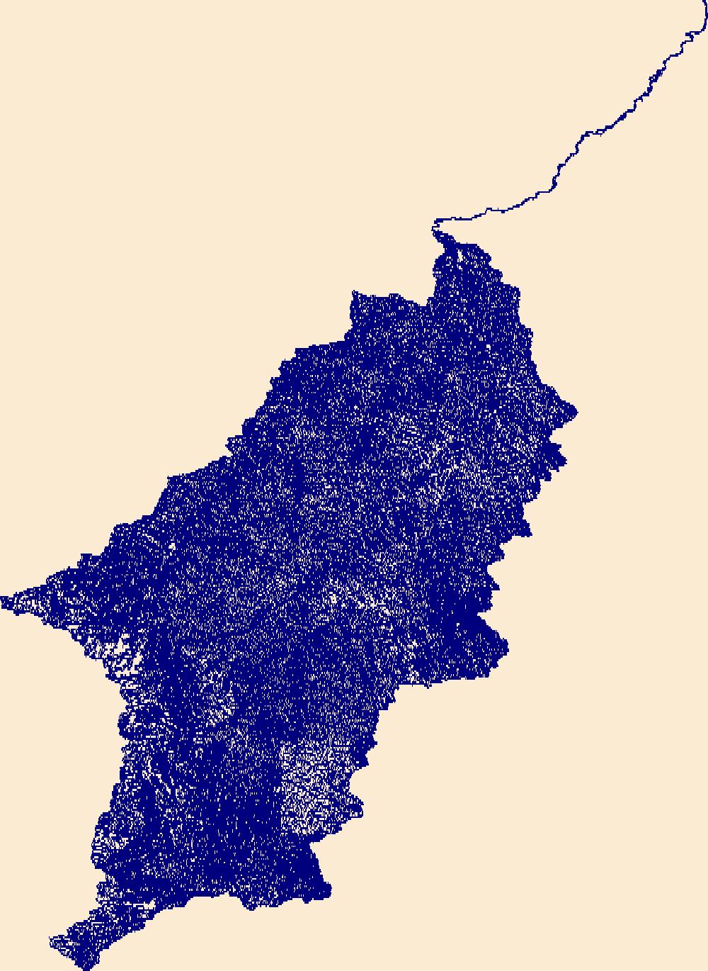
The High Resolution National Hydrography Dataset Plus (NHDPlus HR) is an integrated set of geospatial data layers, including the best available National Hydrography Dataset (NHD), the 10-meter 3D Elevation Program Digital Elevation Model (3DEP DEM), and the National Watershed Boundary Dataset (WBD). The NHDPlus HR combines the NHD, 3DEP DEMs, and WBD to create a stream network with linear referencing, feature naming, "value added attributes" (VAAs), elevation-derived catchments, and other features for hydrologic data analysis. The stream network with linear referencing is a system of data relationships applied to hydrographic systems so that one stream reach "flows" into another and "events" can be tied to and traced...
The High Resolution National Hydrography Dataset Plus (NHDPlus HR) is an integrated set of geospatial data layers, including the best available National Hydrography Dataset (NHD), the 10-meter 3D Elevation Program Digital Elevation Model (3DEP DEM), and the National Watershed Boundary Dataset (WBD). The NHDPlus HR combines the NHD, 3DEP DEMs, and WBD to create a stream network with linear referencing, feature naming, "value added attributes" (VAAs), elevation-derived catchments, and other features for hydrologic data analysis. The stream network with linear referencing is a system of data relationships applied to hydrographic systems so that one stream reach "flows" into another and "events" can be tied to and traced...
The High Resolution National Hydrography Dataset Plus (NHDPlus HR) is an integrated set of geospatial data layers, including the best available National Hydrography Dataset (NHD), the 10-meter 3D Elevation Program Digital Elevation Model (3DEP DEM), and the National Watershed Boundary Dataset (WBD). The NHDPlus HR combines the NHD, 3DEP DEMs, and WBD to create a stream network with linear referencing, feature naming, "value added attributes" (VAAs), elevation-derived catchments, and other features for hydrologic data analysis. The stream network with linear referencing is a system of data relationships applied to hydrographic systems so that one stream reach "flows" into another and "events" can be tied to and traced...

The High Resolution National Hydrography Dataset Plus (NHDPlus HR) is an integrated set of geospatial data layers, including the National Hydrography Dataset (NHD), National Watershed Boundary Dataset (WBD), and 3D Elevation Program Digital Elevation Model (3DEP DEM). The NHDPlus HR combines the NHD, 3DEP DEMs, and WBD to a data suite that includes the NHD stream network with linear referencing functionality, the WBD hydrologic units, elevation-derived catchment areas for each stream segment, "value added attributes" (VAAs), and other features that enhance hydrologic data analysis and routing.

The High Resolution National Hydrography Dataset Plus (NHDPlus HR) is an integrated set of geospatial data layers, including the National Hydrography Dataset (NHD), National Watershed Boundary Dataset (WBD), and 3D Elevation Program Digital Elevation Model (3DEP DEM). The NHDPlus HR combines the NHD, 3DEP DEMs, and WBD to a data suite that includes the NHD stream network with linear referencing functionality, the WBD hydrologic units, elevation-derived catchment areas for each stream segment, "value added attributes" (VAAs), and other features that enhance hydrologic data analysis and routing.

The High Resolution National Hydrography Dataset Plus (NHDPlus HR) is an integrated set of geospatial data layers, including the best available National Hydrography Dataset (NHD), the 10-meter 3D Elevation Program Digital Elevation Model (3DEP DEM), and the National Watershed Boundary Dataset (WBD). The NHDPlus HR combines the NHD, 3DEP DEMs, and WBD to create a stream network with linear referencing, feature naming, "value added attributes" (VAAs), elevation-derived catchments, and other features for hydrologic data analysis. The stream network with linear referencing is a system of data relationships applied to hydrographic systems so that one stream reach "flows" into another and "events" can be tied to and traced...

The High Resolution National Hydrography Dataset Plus (NHDPlus HR) is an integrated set of geospatial data layers, including the best available National Hydrography Dataset (NHD), the 10-meter 3D Elevation Program Digital Elevation Model (3DEP DEM), and the National Watershed Boundary Dataset (WBD). The NHDPlus HR combines the NHD, 3DEP DEMs, and WBD to create a stream network with linear referencing, feature naming, "value added attributes" (VAAs), elevation-derived catchments, and other features for hydrologic data analysis. The stream network with linear referencing is a system of data relationships applied to hydrographic systems so that one stream reach "flows" into another and "events" can be tied to and traced...
The High Resolution National Hydrography Dataset Plus (NHDPlus HR) is an integrated set of geospatial data layers, including the best available National Hydrography Dataset (NHD), the 10-meter 3D Elevation Program Digital Elevation Model (3DEP DEM), and the National Watershed Boundary Dataset (WBD). The NHDPlus HR combines the NHD, 3DEP DEMs, and WBD to create a stream network with linear referencing, feature naming, "value added attributes" (VAAs), elevation-derived catchments, and other features for hydrologic data analysis. The stream network with linear referencing is a system of data relationships applied to hydrographic systems so that one stream reach "flows" into another and "events" can be tied to and traced...
The High Resolution National Hydrography Dataset Plus (NHDPlus HR) is an integrated set of geospatial data layers, including the best available National Hydrography Dataset (NHD), the 10-meter 3D Elevation Program Digital Elevation Model (3DEP DEM), and the National Watershed Boundary Dataset (WBD). The NHDPlus HR combines the NHD, 3DEP DEMs, and WBD to create a stream network with linear referencing, feature naming, "value added attributes" (VAAs), elevation-derived catchments, and other features for hydrologic data analysis. The stream network with linear referencing is a system of data relationships applied to hydrographic systems so that one stream reach "flows" into another and "events" can be tied to and traced...
The High Resolution National Hydrography Dataset Plus (NHDPlus HR) is an integrated set of geospatial data layers, including the best available National Hydrography Dataset (NHD), the 10-meter 3D Elevation Program Digital Elevation Model (3DEP DEM), and the National Watershed Boundary Dataset (WBD). The NHDPlus HR combines the NHD, 3DEP DEMs, and WBD to create a stream network with linear referencing, feature naming, "value added attributes" (VAAs), elevation-derived catchments, and other features for hydrologic data analysis. The stream network with linear referencing is a system of data relationships applied to hydrographic systems so that one stream reach "flows" into another and "events" can be tied to and traced...
The High Resolution National Hydrography Dataset Plus (NHDPlus HR) is an integrated set of geospatial data layers, including the best available National Hydrography Dataset (NHD), the 10-meter 3D Elevation Program Digital Elevation Model (3DEP DEM), and the National Watershed Boundary Dataset (WBD). The NHDPlus HR combines the NHD, 3DEP DEMs, and WBD to create a stream network with linear referencing, feature naming, "value added attributes" (VAAs), elevation-derived catchments, and other features for hydrologic data analysis. The stream network with linear referencing is a system of data relationships applied to hydrographic systems so that one stream reach "flows" into another and "events" can be tied to and traced...
The High Resolution National Hydrography Dataset Plus (NHDPlus HR) is an integrated set of geospatial data layers, including the best available National Hydrography Dataset (NHD), the 10-meter 3D Elevation Program Digital Elevation Model (3DEP DEM), and the National Watershed Boundary Dataset (WBD). The NHDPlus HR combines the NHD, 3DEP DEMs, and WBD to create a stream network with linear referencing, feature naming, "value added attributes" (VAAs), elevation-derived catchments, and other features for hydrologic data analysis. The stream network with linear referencing is a system of data relationships applied to hydrographic systems so that one stream reach "flows" into another and "events" can be tied to and traced...
Airborne electromagnetic (AEM), magnetic, and radiometric data were acquired September 2021 to January 2022 along 27,204 line-kilometers (line-km) over the Mississippi Alluvial Plain (MAP), Mississippi Embayment, and Gulf Coastal Plain. Data were acquired by Xcalibur Multiphysics (Canada), Ltd. with three different airborne sensors: the 30Hz TEMPEST time-domain AEM instrument that is used to map subsurface geologic structure at depths up to 300 meters (m) depending on the subsurface resistivity; a Scintrex CS-3 cesium vapor magnetometer that detects changes in deep (hundreds of meters to kilometers) geologic structure based on variations in the magnetic properties of different formations; and a Radiation Solutions...
Categories: Data;
Types: Downloadable,
Map Service,
OGC WFS Layer,
OGC WMS Layer,
Shapefile;
Tags: Arkansas,
Arkansas River,
GGGSC,
Geology, Geophysics, and Geochemistry Science Center,
Illinois,
|

|
