Filters: Tags: IVMP (X) > partyWithName: Conservation Biology Institute (X)
31 results (13ms)|
Filters
Date Range
Tag Schemes |

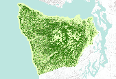
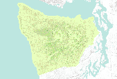
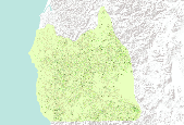
This theme shows broadleaf cover for the Coast Oregon physiographic province of the Interagency Vegetation Mapping Project (IVMP). The Interagency Vegetation Mapping Project (IVMP) provides maps of existing vegetation, canopy cover, size, and cover type for the entire range of the Northern Spotted Owl using satellite imagery from the Landsat Thematic Mapper (TM). This area is commonly called the FEMAT area, in reference to the area's analysis by the Forest Ecosystem Management Assessment Team. A regression modeling approach was used to predict vegetation characteristics from this Landsat data. This process involved the use of numerous sources of ancillary data, the most crucial being USFS, BLM, and Forest Inventory...
This theme shows broadleaf cover for the Coast Oregon physiographic province of the Interagency Vegetation Mapping Project (IVMP). The Interagency Vegetation Mapping Project (IVMP) provides maps of existing vegetation, canopy cover, size, and cover type for the entire range of the Northern Spotted Owl using satellite imagery from the Landsat Thematic Mapper (TM). This area is commonly called the FEMAT area, in reference to the area's analysis by the Forest Ecosystem Management Assessment Team. A regression modeling approach was used to predict vegetation characteristics from this Landsat data. This process involved the use of numerous sources of ancillary data, the most crucial being USFS, BLM, and Forest Inventory...

This theme shows broadleaf cover for the Coast Oregon physiographic province of the Interagency Vegetation Mapping Project (IVMP). The Interagency Vegetation Mapping Project (IVMP) provides maps of existing vegetation, canopy cover, size, and cover type for the entire range of the Northern Spotted Owl using satellite imagery from the Landsat Thematic Mapper (TM). This area is commonly called the FEMAT area, in reference to the area's analysis by the Forest Ecosystem Management Assessment Team. A regression modeling approach was used to predict vegetation characteristics from this Landsat data. This process involved the use of numerous sources of ancillary data, the most crucial being USFS, BLM, and Forest Inventory...

The Interagency Vegetation Mapping Project (IVMP) provides maps of existing vegetation, canopy cover, size, and cover type for the entire range of the Northern Spotted Owl using satellite imagery from the Landsat Thematic Mapper (TM). This area is commonly called the FEMAT area, in reference to the area's analysis by the Forest Ecosystem Management Assessment Team. A regression modeling approach was used to predict vegetation characteristics from this Landsat data. This process involved the use of numerous sources of ancillary data, the most crucial being USFS, BLM, and Forest Inventory and Analysis (FIA) plot field data and plot photo interpreted information. This data served as training data in the regression...

The Interagency Vegetation Mapping Project (IVMP) provides maps of existing vegetation, canopy cover, size, and cover type for the entire range of the Northern Spotted Owl using satellite imagery from the Landsat Thematic Mapper (TM). This area is commonly called the FEMAT area, in reference to the area's analysis by the Forest Ecosystem Management Assessment Team. A regression modeling approach was used to predict vegetation characteristics from this Landsat data. This process involved the use of numerous sources of ancillary data, the most crucial being USFS, BLM, and Forest Inventory and Analysis (FIA) plot field data and plot photo interpreted information. This data served as training data in the regression...
The Interagency Vegetation Mapping Project (IVMP) provides maps of existing vegetation, canopy cover, size, and cover type for the entire range of the Northern Spotted Owl using satellite imagery from the Landsat Thematic Mapper (TM). This area is commonly called the FEMAT area, in reference to the area's analysis by the Forest Ecosystem Management Assessment Team. A regression modeling approach was used to predict vegetation characteristics from this Landsat data. This process involved the use of numerous sources of ancillary data, the most crucial being USFS, BLM, and Forest Inventory and Analysis (FIA) plot field data and plot photo interpreted information. This data served as training data in the regression...

The Interagency Vegetation Mapping Project (IVMP) provides maps of existing vegetation, canopy cover, size, and cover type for the entire range of the Northern Spotted Owl using satellite imagery from the Landsat Thematic Mapper (TM). This area is commonly called the FEMAT area, in reference to the area's analysis by the Forest Ecosystem Management Assessment Team. A regression modeling approach was used to predict vegetation characteristics from this Landsat data. This process involved the use of numerous sources of ancillary data, the most crucial being USFS, BLM, and Forest Inventory and Analysis (FIA) plot field data and plot photo interpreted information. This data served as training data in the regression...

The Interagency Vegetation Mapping Project (IVMP) provides maps of existing vegetation, canopy cover, size, and cover type for the entire range of the Northern Spotted Owl using satellite imagery from the Landsat Thematic Mapper (TM). This area is commonly called the FEMAT area, in reference to the area's analysis by the Forest Ecosystem Management Assessment Team. A regression modeling approach was used to predict vegetation characteristics from this Landsat data. This process involved the use of numerous sources of ancillary data, the most crucial being USFS, BLM, and Forest Inventory and Analysis (FIA) plot field data and plot photo interpreted information. This data served as training data in the regression...

The Interagency Vegetation Mapping Project (IVMP) provides maps of existing vegetation, canopy cover, size, and cover type for the entire range of the Northern Spotted Owl using satellite imagery from the Landsat Thematic Mapper (TM). This area is commonly called the FEMAT area, in reference to the area's analysis by the Forest Ecosystem Management Assessment Team. A regression modeling approach was used to predict vegetation characteristics from this Landsat data. This process involved the use of numerous sources of ancillary data, the most crucial being USFS, BLM, and Forest Inventory and Analysis (FIA) plot field data and plot photo interpreted information. This data served as training data in the regression...

This theme shows broadleaf cover for the Coast Oregon physiographic province of the Interagency Vegetation Mapping Project (IVMP). The Interagency Vegetation Mapping Project (IVMP) provides maps of existing vegetation, canopy cover, size, and cover type for the entire range of the Northern Spotted Owl using satellite imagery from the Landsat Thematic Mapper (TM). This area is commonly called the FEMAT area, in reference to the area's analysis by the Forest Ecosystem Management Assessment Team. A regression modeling approach was used to predict vegetation characteristics from this Landsat data. This process involved the use of numerous sources of ancillary data, the most crucial being USFS, BLM, and Forest Inventory...
The Interagency Vegetation Mapping Project (IVMP) provides maps of existing vegetation, canopy cover, size, and cover type for the entire range of the Northern Spotted Owl using satellite imagery from the Landsat Thematic Mapper (TM). This area is commonly called the FEMAT area, in reference to the area's analysis by the Forest Ecosystem Management Assessment Team. A regression modeling approach was used to predict vegetation characteristics from this Landsat data. This process involved the use of numerous sources of ancillary data, the most crucial being USFS, BLM, and Forest Inventory and Analysis (FIA) plot field data and plot photo interpreted information. This data served as training data in the regression...

The Interagency Vegetation Mapping Project (IVMP) provides maps of existing vegetation, canopy cover, size, and cover type for the entire range of the Northern Spotted Owl using satellite imagery from the Landsat Thematic Mapper (TM). This area is commonly called the FEMAT area, in reference to the area's analysis by the Forest Ecosystem Management Assessment Team. A regression modeling approach was used to predict vegetation characteristics from this Landsat data. This process involved the use of numerous sources of ancillary data, the most crucial being USFS, BLM, and Forest Inventory and Analysis (FIA) plot field data and plot photo interpreted information. This data served as training data in the regression...

This theme shows broadleaf cover for the Coast Oregon physiographic province of the Interagency Vegetation Mapping Project (IVMP). The Interagency Vegetation Mapping Project (IVMP) provides maps of existing vegetation, canopy cover, size, and cover type for the entire range of the Northern Spotted Owl using satellite imagery from the Landsat Thematic Mapper (TM). This area is commonly called the FEMAT area, in reference to the area's analysis by the Forest Ecosystem Management Assessment Team. A regression modeling approach was used to predict vegetation characteristics from this Landsat data. This process involved the use of numerous sources of ancillary data, the most crucial being USFS, BLM, and Forest Inventory...

This theme shows broadleaf cover for the Coast Oregon physiographic province of the Interagency Vegetation Mapping Project (IVMP). The Interagency Vegetation Mapping Project (IVMP) provides maps of existing vegetation, canopy cover, size, and cover type for the entire range of the Northern Spotted Owl using satellite imagery from the Landsat Thematic Mapper (TM). This area is commonly called the FEMAT area, in reference to the area's analysis by the Forest Ecosystem Management Assessment Team. A regression modeling approach was used to predict vegetation characteristics from this Landsat data. This process involved the use of numerous sources of ancillary data, the most crucial being USFS, BLM, and Forest Inventory...

The Interagency Vegetation Mapping Project (IVMP) provides maps of existing vegetation, canopy cover, size, and cover type for the entire range of the Northern Spotted Owl using satellite imagery from the Landsat Thematic Mapper (TM). This area is commonly called the FEMAT area, in reference to the area's analysis by the Forest Ecosystem Management Assessment Team. A regression modeling approach was used to predict vegetation characteristics from this Landsat data. This process involved the use of numerous sources of ancillary data, the most crucial being USFS, BLM, and Forest Inventory and Analysis (FIA) plot field data and plot photo interpreted information. This data served as training data in the regression...

This theme shows broadleaf cover for the Coast Oregon physiographic province of the Interagency Vegetation Mapping Project (IVMP). The Interagency Vegetation Mapping Project (IVMP) provides maps of existing vegetation, canopy cover, size, and cover type for the entire range of the Northern Spotted Owl using satellite imagery from the Landsat Thematic Mapper (TM). This area is commonly called the FEMAT area, in reference to the area's analysis by the Forest Ecosystem Management Assessment Team. A regression modeling approach was used to predict vegetation characteristics from this Landsat data. This process involved the use of numerous sources of ancillary data, the most crucial being USFS, BLM, and Forest Inventory...

The Interagency Vegetation Mapping Project (IVMP) provides maps of existing vegetation, canopy cover, size, and cover type for the entire range of the Northern Spotted Owl using satellite imagery from the Landsat Thematic Mapper (TM). This area is commonly called the FEMAT area, in reference to the area's analysis by the Forest Ecosystem Management Assessment Team. A regression modeling approach was used to predict vegetation characteristics from this Landsat data. This process involved the use of numerous sources of ancillary data, the most crucial being USFS, BLM, and Forest Inventory and Analysis (FIA) plot field data and plot photo interpreted information. This data served as training data in the regression...

The Interagency Vegetation Mapping Project (IVMP) provides maps of existing vegetation, canopy cover, size, and cover type for the entire range of the Northern Spotted Owl using satellite imagery from the Landsat Thematic Mapper (TM). This area is commonly called the FEMAT area, in reference to the area's analysis by the Forest Ecosystem Management Assessment Team. A regression modeling approach was used to predict vegetation characteristics from this Landsat data. This process involved the use of numerous sources of ancillary data, the most crucial being USFS, BLM, and Forest Inventory and Analysis (FIA) plot field data and plot photo interpreted information. This data served as training data in the regression...

The Interagency Vegetation Mapping Project (IVMP) provides maps of existing vegetation, canopy cover, size, and cover type for the entire range of the Northern Spotted Owl using satellite imagery from the Landsat Thematic Mapper (TM). This area is commonly called the FEMAT area, in reference to the area's analysis by the Forest Ecosystem Management Assessment Team. A regression modeling approach was used to predict vegetation characteristics from this Landsat data. This process involved the use of numerous sources of ancillary data, the most crucial being USFS, BLM, and Forest Inventory and Analysis (FIA) plot field data and plot photo interpreted information. This data served as training data in the regression...

The Interagency Vegetation Mapping Project (IVMP) provides maps of existing vegetation, canopy cover, size, and cover type for the entire range of the Northern Spotted Owl using satellite imagery from the Landsat Thematic Mapper (TM). This area is commonly called the FEMAT area, in reference to the area's analysis by the Forest Ecosystem Management Assessment Team. A regression modeling approach was used to predict vegetation characteristics from this Landsat data. This process involved the use of numerous sources of ancillary data, the most crucial being USFS, BLM, and Forest Inventory and Analysis (FIA) plot field data and plot photo interpreted information. This data served as training data in the regression...
|

|
