Filters: Tags: Kiowa County (X) > Date Range: {"choice":"year"} (X)
14 results (15ms)|
Filters
Date Types (for Date Range)
Types Contacts
Categories Tag Types Tag Schemes |
A previously published MODFLOW-NWT groundwater-flow model for the Rush Springs aquifer in western Oklahoma (using 1 steady state stress period followed by 444 monthly stress periods representing 1979-2015; Ellis, 2018a) was used as the basis of several groundwater-use scenarios. The model is a 3-layer model including the Cloud Chief formation (confining unit of the Rush Springs aquifer), alluvial and terrace deposits, and the Rush Springs aquifer. The scenarios were used to assess the effects of increasing groundwater withdrawals from the Rush Springs aquifer on base flows to streams that flow into Fort Cobb Reservoir to address concerns over groundwater use reducing inflows to the lake. The effects of groundwater...

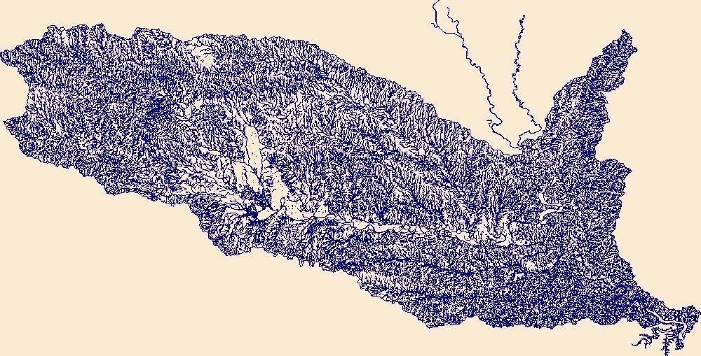
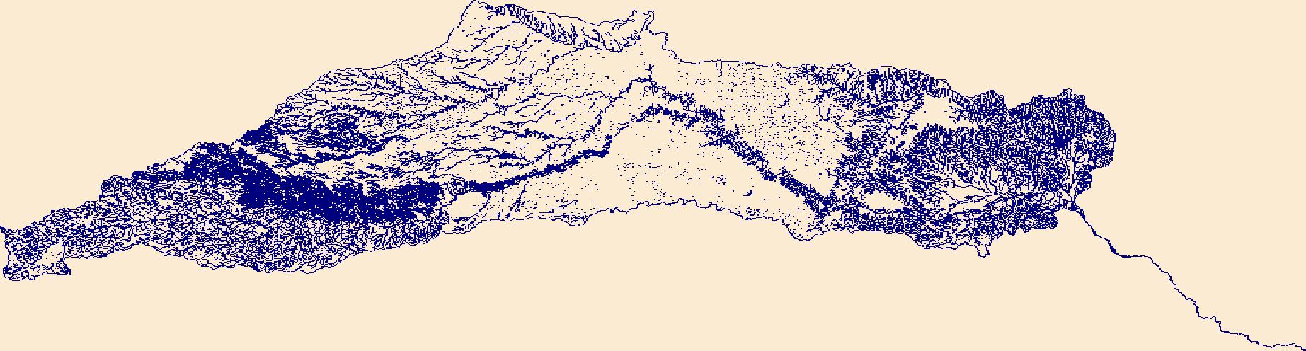
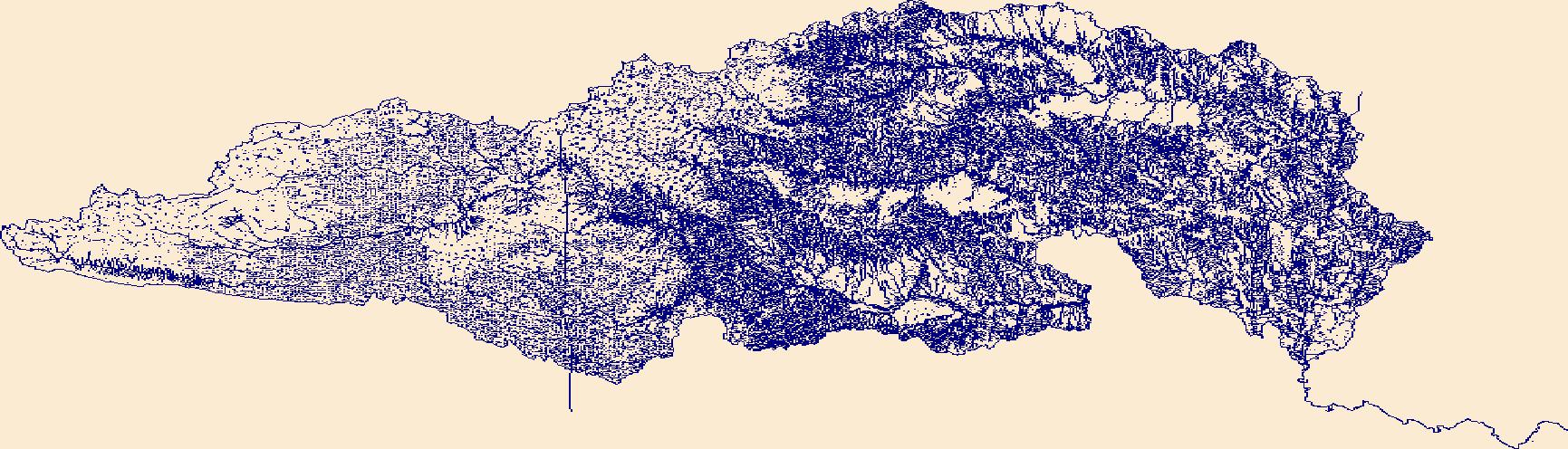
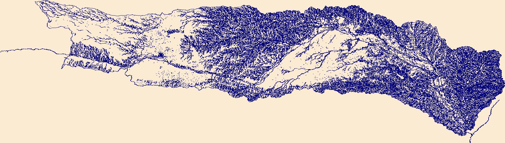
The High Resolution National Hydrography Dataset Plus (NHDPlus HR) is an integrated set of geospatial data layers, including the best available National Hydrography Dataset (NHD), the 10-meter 3D Elevation Program Digital Elevation Model (3DEP DEM), and the National Watershed Boundary Dataset (WBD). The NHDPlus HR combines the NHD, 3DEP DEMs, and WBD to create a stream network with linear referencing, feature naming, "value added attributes" (VAAs), elevation-derived catchments, and other features for hydrologic data analysis. The stream network with linear referencing is a system of data relationships applied to hydrographic systems so that one stream reach "flows" into another and "events" can be tied to and traced...

The High Resolution National Hydrography Dataset Plus (NHDPlus HR) is an integrated set of geospatial data layers, including the best available National Hydrography Dataset (NHD), the 10-meter 3D Elevation Program Digital Elevation Model (3DEP DEM), and the National Watershed Boundary Dataset (WBD). The NHDPlus HR combines the NHD, 3DEP DEMs, and WBD to create a stream network with linear referencing, feature naming, "value added attributes" (VAAs), elevation-derived catchments, and other features for hydrologic data analysis. The stream network with linear referencing is a system of data relationships applied to hydrographic systems so that one stream reach "flows" into another and "events" can be tied to and traced...
The High Resolution National Hydrography Dataset Plus (NHDPlus HR) is an integrated set of geospatial data layers, including the best available National Hydrography Dataset (NHD), the 10-meter 3D Elevation Program Digital Elevation Model (3DEP DEM), and the National Watershed Boundary Dataset (WBD). The NHDPlus HR combines the NHD, 3DEP DEMs, and WBD to create a stream network with linear referencing, feature naming, "value added attributes" (VAAs), elevation-derived catchments, and other features for hydrologic data analysis. The stream network with linear referencing is a system of data relationships applied to hydrographic systems so that one stream reach "flows" into another and "events" can be tied to and traced...
The High Resolution National Hydrography Dataset Plus (NHDPlus HR) is an integrated set of geospatial data layers, including the best available National Hydrography Dataset (NHD), the 10-meter 3D Elevation Program Digital Elevation Model (3DEP DEM), and the National Watershed Boundary Dataset (WBD). The NHDPlus HR combines the NHD, 3DEP DEMs, and WBD to create a stream network with linear referencing, feature naming, "value added attributes" (VAAs), elevation-derived catchments, and other features for hydrologic data analysis. The stream network with linear referencing is a system of data relationships applied to hydrographic systems so that one stream reach "flows" into another and "events" can be tied to and traced...

A previously developed model (https://doi.org/10.3133/sir20175098) was coupled with downscaled climate model data to determine the impact of climate variability on base flow and groundwater storage in the North Fork Red River aquifer, Oklahoma. The North Fork Red River aquifer is an alluvial aquifer that discharges groundwater to the North Fork Red River, which provides inflow to Lake Altus, an important water source for the surrounding communities. The impact of climate variability on hydrologic systems and the resulting effects on basins has become an important topic in assessing future water resources. Global climate projections from general circulation models, including the Coupled Model Intercomparison Project...

In 2017 the U.S. Geological Survey, in cooperation with the Oklahoma Water Resources Board, published a calibrated numerical groundwater-flow model and associated model documentation report that evaluated the effects of potential groundwater withdrawals on groundwater flow and availability in the North Fork Red River aquifer in southwest Oklahoma. The results of groundwater-availability scenarios run on the calibrated numerical groundwater-flow model could be used by the Oklahoma Water Resources Board to reevaluate the maximum annual yield of groundwater from the North Fork Red River aquifer in Oklahoma. The numerical groundwater-flow model was built on a hydrogeologic framework and a conceptual groundwater-flow...
Classified probability of suitable habitat for Black Tailed Prairie Dogs for each cell of raster. Classification is based on 4 probability cutoff levels with category 1 being low habitat suitability and category 4 being high habitat suitability. Categorized probability data is created from fitting a global third-order model to county level raster data. For details on model fitting and data used to produce categorized probability raster see report. https://www.fws.gov/science/catalog
Categories: Data;
Types: Downloadable,
GeoTIFF,
Map Service,
Raster;
Tags: Black Tailed Prairie Dogs,
Colorado,
Great Plains,
Habitat suitability,
Kiowa County,
Classified probability of suitable habitat for Black Tailed Prairie Dogs for each cell of raster. Classification is based on 4 probability cutoff levels with category 1 being low habitat suitability and category 4 being high habitat suitability. Categorized probability data is created from fitting a global second-order model to county level raster data. For details on model fitting and data used to produce categorized probability raster see report. https://www.fws.gov/science/catalog
Categories: Data;
Types: Downloadable,
GeoTIFF,
Map Service,
Raster;
Tags: Black Tailed Prairie Dogs,
Colorado,
Great Plains,
Habitat suitability,
Kiowa County,
The High Resolution National Hydrography Dataset Plus (NHDPlus HR) is an integrated set of geospatial data layers, including the best available National Hydrography Dataset (NHD), the 10-meter 3D Elevation Program Digital Elevation Model (3DEP DEM), and the National Watershed Boundary Dataset (WBD). The NHDPlus HR combines the NHD, 3DEP DEMs, and WBD to create a stream network with linear referencing, feature naming, "value added attributes" (VAAs), elevation-derived catchments, and other features for hydrologic data analysis. The stream network with linear referencing is a system of data relationships applied to hydrographic systems so that one stream reach "flows" into another and "events" can be tied to and traced...

In 2018 The U.S. Geological Survey, in cooperation with the U.S. Bureau of Reclamation and the Oklahoma Water Resources Board, published a calibrated numerical groundwater- flow model and associated model documentation report that evaluated the effects of potential groundwater withdrawals on groundwater flow and availability in the Rush Springs aquifer in western Oklahoma. The results of groundwater-availability scenarios run on the calibrated numerical groundwater-flow model could be used by the Oklahoma Water Resources Board to evaluate the maximum annual yield of groundwater from the Rush Springs aquifer in Oklahoma. A conceptual groundwater-flow model is a simplified description of the major inflow and outflow...
Probability of suitable habitat for Black Tailed Prairie Dogs for each cell of raster. Probability is measured from 0 to 1 with 0 being low habitat suitability and 1 being high suitability. Probability data is created from fitting a global second-order model to county level raster data. For details on model fitting and data used to produce probability raster see report. https://www.fws.gov/science/catalog
Categories: Data;
Types: Downloadable,
GeoTIFF,
Map Service,
Raster;
Tags: Black Tailed Prairie Dogs,
Colorado,
Great Plains,
Habitat suitability,
Kiowa County,
Probability of suitable habitat for Black Tailed Prairie Dogs for each cell of raster. Probability is measured from 0 to 1 with 0 being low habitat suitability and 1 being high suitability. Probability data is created from fitting a global third-order model to county level raster data. For details on model fitting and data used to produce probability raster see report. https://www.fws.gov/science/catalog
Categories: Data;
Types: Downloadable,
GeoTIFF,
Map Service,
Raster;
Tags: Black Tailed Prairie Dogs,
Colorado,
Great Plains,
Habitat suitability,
Kiowa County,
The High Resolution National Hydrography Dataset Plus (NHDPlus HR) is an integrated set of geospatial data layers, including the best available National Hydrography Dataset (NHD), the 10-meter 3D Elevation Program Digital Elevation Model (3DEP DEM), and the National Watershed Boundary Dataset (WBD). The NHDPlus HR combines the NHD, 3DEP DEMs, and WBD to create a stream network with linear referencing, feature naming, "value added attributes" (VAAs), elevation-derived catchments, and other features for hydrologic data analysis. The stream network with linear referencing is a system of data relationships applied to hydrographic systems so that one stream reach "flows" into another and "events" can be tied to and traced...
|

|
