Filters: Tags: LAS (X) > Date Range: {"choice":"year"} (X)
23 results (34ms)|
Filters
Date Types (for Date Range)
Types Contacts
Categories Tag Types Tag Schemes |
This dataset is a LAS (industry-standard binary format for storing lidar point clouds) dataset containing light detection and ranging (lidar) data and sonar data representing the beach and near-shore topography of Lake Superior at Minnesota Point, near the Duluth entry, Duluth, Minnesota. Average point spacing of the LAS files in the dataset are as follows: lidar, 0.094 meters (m); multibeam sonar, 0.501 m; single-beam sonar, 1.876 m. The LAS dataset was used to create digital elevation models (DEMs) of 10 m (32.8084 feet) and 1 m (3.28084 feet) resolution, of the approximate 1.75 square kilometer surveyed area. Lidar data were collected August 22, 2022 using a boat mounted Velodyne VLP-16 unit and methodology similar...
Categories: Data;
Types: Downloadable,
Map Service,
OGC WFS Layer,
OGC WMS Layer,
Shapefile;
Tags: Bathymetry and Elevation,
DEM,
Duluth,
Great Lakes,
Hydroacoustic,
This dataset is comprised of three files containing northing, easting, and elevation ("XYZ") information for light detection and ranging (lidar) data representing the beach topography and sonar data representing near-shore topography of Lake Superior at Minnesota Point, near the Duluth entry, Duluth, Minnesota. The point data is the same as that in LAS files that were used to create the digital elevation models (DEMs) of the approximate 2.15 square kilometer surveyed area. Lidar data were collected September 07, 2022 using a boat mounted Velodyne VLP-16 unit and methodology similar to that described by Huizinga and Wagner (2019). Multibeam sonar data were collected September 06-07, 2022 using a Norbit integrated...
These data are digital elevation models (DEMs) of the beach topography and near-shore bathymetry of Lake Superior at Minnesota Point, near the Superior entry, Duluth, Minnesota. The DEMs have 1 meter (m; 3.28084 ft) and/or 10 m (32.8084 ft) cell size and was created from a LAS dataset of terrestrial light detection and ranging (LiDAR) data representing the beach topography and sonar data representing the bathymetry for an approximate 1.78 square kilometer survey area. Average point spacing of the LAS files in the dataset are as follows: lidar, 0.055 meters (m); multibeam sonar, 0.511 m; single-beam sonar, 1.687 m. Lidar data were collected November 01, 2022 using a boat mounted Velodyne VLP-16 unit and methodology...
Categories: Data;
Types: Downloadable,
GeoTIFF,
Map Service,
Raster;
Tags: Bathymetry and Elevation,
DEM,
Duluth,
Great Lakes,
Hydroacoustic,
This dataset is a LAS (industry-standard binary format for storing lidar point clouds) dataset containing light detection and ranging (lidar) data and sonar data representing the beach and near-shore bathymetry of Lake Superior at Minnesota Point, near the Duluth entry, Duluth, Minnesota. Average point spacing of the LAS files in the dataset are as follows: lidar, 0.055 meters (m); multibeam sonar, 0.511 m; single-beam sonar, 1.687 m. The LAS dataset was used to create digital elevation models (DEMs) of 10 m (32.8084 feet) and 1 m (3.28084 feet) cell size, of the approximate 1.78 square kilometer surveyed area. Lidar data were collected November 01, 2022 using a boat mounted Velodyne VLP-16 unit and methodology...
Categories: Data;
Types: Downloadable,
Map Service,
OGC WFS Layer,
OGC WMS Layer,
Shapefile;
Tags: Bathymetry and Elevation,
DEM,
Duluth,
Great Lakes,
Hydroacoustic,
During 2017 and 2018, the U.S. Geological Survey (USGS) Idaho National Laboratory Project Office, in cooperation with the U.S. Department of Energy (DOE), drilled and constructed borehole USGS 145 (USGS site 433358113042701) for hydrogeologic data collection and stratigraphic framework analyses. The well is located along the western boundary of the Idaho National Laboratory (INL) just south of highway 20. USGS 145 was continuously cored from approximately 3 to 1,368 feet below land surface (BLS), and had water level of 704.73 ft BLS directly after drilling. Core was recovered over a two-year period, this includes cored depths from 3 to 678 ft between May 30, 2017,and November 13, 2017, and from 678 to 1,368 ft between...
Categories: Data;
Types: Map Service,
OGC WFS Layer,
OGC WMS Layer,
OGC WMS Service;
Tags: 433358113042701,
ATV,
Butte County,
Eastern Snake River Plain,
Eastern Snake River Plain Aquifer,
The elevation contours in this dataset have a 2-foot (ft) interval and were derived from a digital elevation model (DEM) of beach topography and nearshore bathymetry of Lake Superior at Minnesota Point, Duluth, Minnesota. The DEM has a 1 meter (m; 3.28084 ft) cell size and was created from Lidar data representing beach topography and sonar data representing bathymetry extending approximately 700-800 m offshore. The data cover an approximately 1.75 square kilometer survey area. Lidar data were collected November 01, 2022 using a boat mounted Velodyne VLP-16 unit and methodology similar to that described by Huizinga and Wagner (2019). Multibeam sonar data were collected October 31-November 01, 2022 using a Norbit...
Categories: Data;
Types: Downloadable,
Map Service,
OGC WFS Layer,
OGC WMS Layer,
Shapefile;
Tags: Bathymetry and Elevation,
DEM,
Duluth,
Great Lakes,
Hydroacoustic,
In May 2023, the U.S. Geological Survey provided training for bathymetric data acquisition and processing for the Iraq Ministry of Water Resources. The training included multibeam sonar theory, survey planning, data collection and processing, and dissemination. This data release presents the raw survey data, a digital elevation model (DEM), and a thalweg shapefile for three survey areas in the Pacific Northwest, USA (Mores Creek, Idaho; Columbia River, OR; Willamette River, OR). Additionally, metadata describes the processing steps, quality assurance and control, and an overall summary of each dataset. The bathymetry point cloud data were collected at selected study sites in the Pacific Northwest, U.S.A, May 2023...
These data are digital elevation models (DEMs) of the beach topography and near-shore bathymetry of Lake Superior at Minnesota Point, near the Superior entry, Duluth, Minnesota. The DEMs have 1 meter (m) and/or 10 m cell size and was created from a LAS dataset of terrestrial light detection and ranging (LiDAR) data representing the beach topography and sonar data representing the bathymetry for an approximate 2.15 square kilometer survey area. Average point spacing of the LAS files in the dataset are as follows: Lidar, 0.086 m; multi-beam sonar, 0.512 m; single-beam sonar, 1.919 m. Lidar data were collected September 07, 2022 using a boat mounted Velodyne VLP-16 unit and methodology similar to that described by...
Categories: Data;
Types: Downloadable,
GeoTIFF,
Map Service,
Raster;
Tags: Bathymetry and Elevation,
DEM,
Duluth,
Great Lakes,
Hydroacoustic,
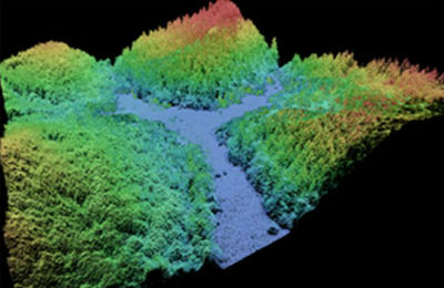
This data collection of the 3D Elevation Program (3DEP) consists of Lidar Point Cloud (LPC) projects as provided to the USGS. These point cloud files contain all the original lidar points collected, with the original spatial reference and units preserved. These data may have been used as the source of updates to the 1/3-arcsecond, 1-arcsecond, and 2-arcsecond seamless 3DEP Digital Elevation Models (DEMs). The 3DEP data holdings serve as the elevation layer of The National Map, and provide foundational elevation information for earth science studies and mapping applications in the United States. Lidar (Light detection and ranging) discrete-return point cloud data are available in LAZ format. The LAZ format is a lossless...
Topobathy was surveyed during the fall of 2022 for two locations along Minnesota Point, where past beach nourishment (dredge materials) were placed. These topobathymetric surveys of Minnesota Point and Lake Superior are repeat surveys that will be used evaluate movement of placed material and overall change of near-shore bathymetry. The data was acquired using a lidar sensor, and single-beam and multibeam sonars. The data includes DEMs of the terrestrial beach areas and near-shore bathymetries of Lake Superior near the Duluth and Superior entries of Minnesota Point, 2-foot smoothed contours, LAS and XYZ files. Data were collected in cooperation with the U.S. Army Corps of Engineers (USACE), Detroit District.
This dataset is comprised of three files containing northing, easting, and elevation ("XYZ") information for light detection and ranging (lidar) data representing the beach topography and sonar data representing near-shore bathymetry of Lake Superior at Minnesota Point, near the Duluth entry, Duluth, Minnesota. The point data are the same as that in the LAS files that were used to create the digital elevation models (DEMs) of the approximate 1.78 square kilometer surveyed area. Lidar data were collected November 01, 2022 using a boat mounted Velodyne VLP-16 unit and methodology similar to that described by Huizinga and Wagner (2019). Multibeam sonar data were collected October 31-November 01, 2022 using a Norbit...
In 2016, the U.S. Geological Survey (USGS), in cooperation with the U.S. Department of Energy (DOE), drilled and constructed borehole USGS 144 (433021112552501) for stratigraphic framework analyses and water quality monitoring at the Idaho National Laboratory (INL), located in southeastern Idaho. Borehole USGS 144 was continuously cored from approximately 4 to 639 ft below land surface (BLS). The final construction depth, after reaming out cored section of the well, is 620 ft BLS. The USGS INL Project Office drilling team performed the core drilling operations and well construction between August 22, 2016, to December 7, 2016. The USGS collected geophysical data, daily drilling notes, and prepared detailed core...
Categories: Data;
Types: Map Service,
OGC WFS Layer,
OGC WMS Layer,
OGC WMS Service;
Tags: 433021112552501,
ATV,
Butte County,
Eastern Snake River Plain,
Eastern Snake River Plain Aquifer,
In May 2023, the U.S. Geological Survey provided training for bathymetric data acquisition and processing for the Iraq Ministry of Water Resources. The training included multibeam sonar theory, survey planning, data collection and processing, and dissemination. This data release presents the raw survey data, a digital elevation model (DEM), and a thalweg shapefile for three survey areas in the Pacific Northwest, USA (Mores Creek, Idaho; Columbia River, OR; Willamette River, OR). Additionally, metadata describes the processing steps, quality assurance and control, and an overall summary of each dataset. The bathymetry point cloud data were collected at selected study sites in the Pacific Northwest, U.S.A, May 2023...
Aerial photographs were collected from a small, fixed-wing aircraft over the coast of Barter Island, Alaska on three separate dates: July 01 2014, September 07 2014, and July 05 2015. Precise aircraft position information and structure-from-motion photogrammetric methods were combined to derive high-resolution orthophotomosaics and elevation point clouds. Ground control acquired using precise positioning were used to co-register the data sets to assess accuracy of the data sets. Data were shifted into common earth-based datum established from surveyed ground control points and edited to remove outliers, structures, and spurious elevation values associated with moving water surfaces. The horizontal coordinate system...
Categories: Data;
Tags: Arctic National Wildlife Refuge,
Barter Island,
Beaufort Sea,
CMHRP,
Coastal and Marine Hazards and Resources Program,
In May 2023, the U.S. Geological Survey provided training for bathymetric data acquisition and processing for the Iraq Ministry of Water Resources. The training included multibeam sonar theory, survey planning, data collection and processing, and dissemination. This data release presents the raw survey data, a digital elevation model (DEM), and a thalweg shapefile for three survey areas in the Pacific Northwest, USA (Mores Creek, Idaho; Columbia River, OR; Willamette River, OR). Additionally, metadata describes the processing steps, quality assurance and control, and an overall summary of each dataset. The bathymetry point cloud data were collected at selected study sites in the Pacific Northwest, U.S.A, May 2023...
This dataset is comprised of three files containing northing, easting, and elevation ("XYZ") information for light detection and ranging (lidar) data representing the beach topography and sonar data representing near-shore bathymetry of Lake Superior at Minnesota Point, near the Duluth entry, Duluth, Minnesota. The point data are the same as that in LAS files that were used to create the digital elevation models (DEMs) of the approximate 1.75 square kilometer survey area. Lidar data were collected August 22, 2022 using a boat mounted Velodyne VLP-16 unit and methodology similar to that described by Huizinga and Wagner (2019). Multibeam sonar data were collected August 22-23, 2022 using a Norbit integrated wide band...
In May 2023, the U.S. Geological Survey provided training for bathymetric data acquisition and processing for the Iraq Ministry of Water Resources. The training included multibeam sonar theory, survey planning, data collection and processing, and dissemination. This data release presents the raw survey data, a digital elevation model (DEM), and a thalweg shapefile for three survey areas in the Pacific Northwest, USA (Mores Creek, Idaho; Columbia River, OR; Willamette River, OR). Additionally, metadata describes the processing steps, quality assurance and control, and an overall summary of each dataset. The bathymetry point cloud data were collected at selected study sites in the Pacific Northwest, U.S.A, May 2023...
In 2021 and 2022, the U.S. Geological Survey (USGS), in cooperation with the Idaho Department of Water Resources (IDWR), drilled and constructed well SEP 16 (431900112593601) approximately 6 miles south-southeast of Big Southern Butte in Butte County, Idaho. The purpose of the well installation was to collect geologic, geophysical, and hydrologic data. On July 13, 2022, the USGS Idaho National Laboratory Project Office (INLPO) collected select geophysical logs within the cased well including natural gamma, neutron, neutron porosity, and gamma-gamma dual density logs. Gyroscopic deviation data were also collected during geophysical surveying to account for the horizontal and vertical displacement of the well. On...
Categories: Data,
Publication;
Types: Citation,
Map Service,
OGC WFS Layer,
OGC WMS Layer,
OGC WMS Service;
Tags: 431900112593601,
Butte County,
Drilling/completion report,
East Idaho,
Geophysics,
The elevation contours in this dataset have a 2-foot (ft) interval and were derived from a digital elevation model (DEM) of beach topography and nearshore bathymetry of Lake Superior at Minnesota Point, Duluth, Minnesota. The DEM has a 1 meter (m; 3.28084 ft) cell size and was created from Lidar data representing beach topography and sonar data representing bathymetry extending approximately 700-800 m offshore. The data cover an approximately 1.75 square kilometer survey area. Lidar data were collected August 22, 2022 using a boat mounted Velodyne VLP-16 unit and methodology similar to that described by Huizinga and Wagner (2019). Multibeam sonar data were collected August 22-23, 2022 using a Norbit integrated wide...
Categories: Data;
Types: Downloadable,
Map Service,
OGC WFS Layer,
OGC WMS Layer,
Shapefile;
Tags: Bathymetry and Elevation,
DEM,
Duluth,
Great Lakes,
Hydroacoustic,
In support of U.S. Geological Survey (USGS) Southwest Biological Science Center researchers, and in coordination with the Bureau of Land Management (BLM) and National Ecological Observatory Network (NEON), the USGS National Uncrewed Systems Office (NUSO) conducted uncrewed aircraft systems (UAS) remote sensing flights over two BLM Assessment, Inventory, and Monitoring (AIM) plots at the NEON Moab site in Utah for multi-scale carbon sequestration research on public lands. The UAS data collected include natural color, multispectral, and hyperspectral imagery, and lidar to capture diverse information about vegetation and soils on drylands. The first site (“site 1”) features intact sagebrush and was mapped on May 3,...
|

|
