Filters: Tags: LAS (X)
159 results (190ms)|
Filters
Date Range
Extensions Types Contacts
Categories Tag Types Tag Schemes |
Log ASCII Standard (LAS) files of select scanned well logs from Idaho Geological Surveys publication DD-3: Historical Oil and Gas Data for Idaho database of exploration wells across the state. Logs curves converted to LAS files may include: Gamma, Caliper (cal), Resistivity, Spontaneous Potential (SP), Bulk Density, Neutron Porosity, and density porosity. Locations of boreholes, attributes, and PDFs of more than 700 Geophysical logs and other data can be downloaded or viewed at no cost via the Idaho Geological Surveys interactive Oil and Gas webmap.
This dataset is a LAS (industry-standard binary format for storing large point clouds) dataset containing light detection and ranging (LiDAR) data representing beach topography of Lake Superior at Minnesota Point, Duluth, Minnesota. Average point spacing of the LiDAR points in the dataset is 0.137 meters (m; 0.45 feet [ft]). The LAS dataset was used to create a 1-m (3.28084 ft) digital elevation model (DEM) of the approximately 4 kilometer (2.5 mile) surveyed reach of the beach. LiDAR data were collected August 10, 2019 using a boat-mounted Optech ILRIS scanner and methodology similar to that described by Huizinga and Wagner (2019). References: Huizinga, R.J. and Wagner, D.M., 2019, Erosion monitoring along selected...
Types: Map Service,
OGC WFS Layer,
OGC WMS Layer,
OGC WMS Service;
Tags: Bathymetry and Elevation,
DEM,
Duluth,
Great Lakes,
LAS,

Lidar (Light detection and ranging) discrete-return point cloud data are available in the American Society for Photogrammetry and Remote Sensing (ASPRS) LAS format. The LAS format is a standardized binary format for storing 3-dimensional point cloud data and point attributes along with header information and variable length records specific to the data. Millions of data points are stored as a 3-dimensional data cloud as a series of x (longitude), y (latitude) and z (elevation) points. A few older projects in this collection are in ASCII format. Please refer to http://www.asprs.org/Committee-General/LASer-LAS-File-Format-Exchange-Activities.html for additional information.

Lidar (Light detection and ranging) discrete-return point cloud data are available in the American Society for Photogrammetry and Remote Sensing (ASPRS) LAS format. The LAS format is a standardized binary format for storing 3-dimensional point cloud data and point attributes along with header information and variable length records specific to the data. Millions of data points are stored as a 3-dimensional data cloud as a series of x (longitude), y (latitude) and z (elevation) points. A few older projects in this collection are in ASCII format. Please refer to http://www.asprs.org/Committee-General/LASer-LAS-File-Format-Exchange-Activities.html for additional information.
These data are digital elevation models (DEMs) of the beach topography and near-shore bathymetry of Lake Superior at Minnesota Point, near the Superior entry, Duluth, Minnesota. The DEMs have 1 meter (m) and/or 10 m cell size and was created from a LAS dataset of terrestrial light detection and ranging (LiDAR) data representing the beach topography and sonar data representing the bathymetry for an approximate 2.15 square kilometer survey area. Average point spacing of the LAS files in the dataset are as follows: Lidar, 0.086 m; multi-beam sonar, 0.512 m; single-beam sonar, 1.919 m. Lidar data were collected September 07, 2022 using a boat mounted Velodyne VLP-16 unit and methodology similar to that described by...
Categories: Data;
Types: Downloadable,
GeoTIFF,
Map Service,
Raster;
Tags: Bathymetry and Elevation,
DEM,
Duluth,
Great Lakes,
Hydroacoustic,
Low-altitude (80-100 meters above ground level) digital images were obtained from a camera mounted on a 3DR Solo quadcopter, a small unmanned aerial system (UAS), along the Lake Ontario shoreline in New York during July 2017. These data were collected to document and monitor effects of high lake levels, including shoreline erosion, inundation, and property damage in the vicinity of Sodus Bay, New York. This data release includes images tagged with locations determined from the UAS GPS; tables with updated estimates of camera positions and attitudes based on the photogrammetric reconstruction; tables listing locations of the base stations, ground control points, and transect points; geolocated, RGB-colored point...
Imagery acquired with unmanned aerial systems (UAS) and coupled with structure-from-motion (SfM) photogrammetry can produce high-resolution topographic and visual reflectance datasets that rival or exceed lidar and orthoimagery. These new techniques are particularly useful for data collection of coastal systems, which requires high temporal and spatial resolution datasets. The U.S. Geological Survey worked in collaboration with members of the Marine Biological Laboratory and Woods Hole Analytics at Black Beach, in Falmouth, Massachusetts to explore scientific research demands on UAS technology for topographic and habitat mapping applications. This project explored the application of consumer-grade UAS platforms...

Lidar (Light detection and ranging) discrete-return point cloud data are available in the American Society for Photogrammetry and Remote Sensing (ASPRS) LAS format. The LAS format is a standardized binary format for storing 3-dimensional point cloud data and point attributes along with header information and variable length records specific to the data. Millions of data points are stored as a 3-dimensional data cloud as a series of x (longitude), y (latitude) and z (elevation) points. A few older projects in this collection are in ASCII format. Please refer to http://www.asprs.org/Committee-General/LASer-LAS-File-Format-Exchange-Activities.html for additional information.

Lidar (Light detection and ranging) discrete-return point cloud data are available in the American Society for Photogrammetry and Remote Sensing (ASPRS) LAS format. The LAS format is a standardized binary format for storing 3-dimensional point cloud data and point attributes along with header information and variable length records specific to the data. Millions of data points are stored as a 3-dimensional data cloud as a series of x (longitude), y (latitude) and z (elevation) points. A few older projects in this collection are in ASCII format. Please refer to http://www.asprs.org/Committee-General/LASer-LAS-File-Format-Exchange-Activities.html for additional information.

Lidar (Light detection and ranging) discrete-return point cloud data are available in the American Society for Photogrammetry and Remote Sensing (ASPRS) LAS format. The LAS format is a standardized binary format for storing 3-dimensional point cloud data and point attributes along with header information and variable length records specific to the data. Millions of data points are stored as a 3-dimensional data cloud as a series of x (longitude), y (latitude) and z (elevation) points. A few older projects in this collection are in ASCII format. Please refer to http://www.asprs.org/Committee-General/LASer-LAS-File-Format-Exchange-Activities.html for additional information.
Types: Citation;
Tags: Cartography,
DEM,
Digital Elevation Model,
Digital Mapping,
Digital Terrain Model,

Lidar (Light detection and ranging) discrete-return point cloud data are available in the American Society for Photogrammetry and Remote Sensing (ASPRS) LAS format. The LAS format is a standardized binary format for storing 3-dimensional point cloud data and point attributes along with header information and variable length records specific to the data. Millions of data points are stored as a 3-dimensional data cloud as a series of x (longitude), y (latitude) and z (elevation) points. A few older projects in this collection are in ASCII format. Please refer to http://www.asprs.org/Committee-General/LASer-LAS-File-Format-Exchange-Activities.html for additional information.

Lidar (Light detection and ranging) discrete-return point cloud data are available in the American Society for Photogrammetry and Remote Sensing (ASPRS) LAS format. The LAS format is a standardized binary format for storing 3-dimensional point cloud data and point attributes along with header information and variable length records specific to the data. Millions of data points are stored as a 3-dimensional data cloud as a series of x (longitude), y (latitude) and z (elevation) points. A few older projects in this collection are in ASCII format. Please refer to http://www.asprs.org/Committee-General/LASer-LAS-File-Format-Exchange-Activities.html for additional information.

Lidar (Light detection and ranging) discrete-return point cloud data are available in the American Society for Photogrammetry and Remote Sensing (ASPRS) LAS format. The LAS format is a standardized binary format for storing 3-dimensional point cloud data and point attributes along with header information and variable length records specific to the data. Millions of data points are stored as a 3-dimensional data cloud as a series of x (longitude), y (latitude) and z (elevation) points. A few older projects in this collection are in ASCII format. Please refer to http://www.asprs.org/Committee-General/LASer-LAS-File-Format-Exchange-Activities.html for additional information.

Lidar (Light detection and ranging) discrete-return point cloud data are available in the American Society for Photogrammetry and Remote Sensing (ASPRS) LAS format. The LAS format is a standardized binary format for storing 3-dimensional point cloud data and point attributes along with header information and variable length records specific to the data. Millions of data points are stored as a 3-dimensional data cloud as a series of x (longitude), y (latitude) and z (elevation) points. A few older projects in this collection are in ASCII format. Please refer to http://www.asprs.org/Committee-General/LASer-LAS-File-Format-Exchange-Activities.html for additional information.

Lidar (Light detection and ranging) discrete-return point cloud data are available in the American Society for Photogrammetry and Remote Sensing (ASPRS) LAS format. The LAS format is a standardized binary format for storing 3-dimensional point cloud data and point attributes along with header information and variable length records specific to the data. Millions of data points are stored as a 3-dimensional data cloud as a series of x (longitude), y (latitude) and z (elevation) points. A few older projects in this collection are in ASCII format. Please refer to http://www.asprs.org/Committee-General/LASer-LAS-File-Format-Exchange-Activities.html for additional information.

Lidar (Light detection and ranging) discrete-return point cloud data are available in the American Society for Photogrammetry and Remote Sensing (ASPRS) LAS format. The LAS format is a standardized binary format for storing 3-dimensional point cloud data and point attributes along with header information and variable length records specific to the data. Millions of data points are stored as a 3-dimensional data cloud as a series of x (longitude), y (latitude) and z (elevation) points. A few older projects in this collection are in ASCII format. Please refer to http://www.asprs.org/Committee-General/LASer-LAS-File-Format-Exchange-Activities.html for additional information.

Lidar (Light detection and ranging) discrete-return point cloud data are available in the American Society for Photogrammetry and Remote Sensing (ASPRS) LAS format. The LAS format is a standardized binary format for storing 3-dimensional point cloud data and point attributes along with header information and variable length records specific to the data. Millions of data points are stored as a 3-dimensional data cloud as a series of x (longitude), y (latitude) and z (elevation) points. A few older projects in this collection are in ASCII format. Please refer to http://www.asprs.org/Committee-General/LASer-LAS-File-Format-Exchange-Activities.html for additional information.
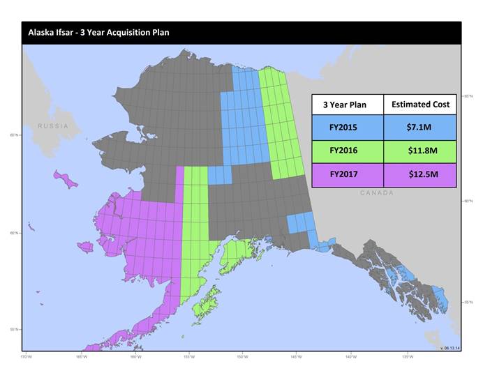
U.S. Geological Survey, Department of the Interior - The annual Alaska IfSAR and DEM acquisition plan is part of the 3DEP initiative to collect high-quality elevation data in the form of interferometric synthetic aperture radar (IfSAR) and light detection and ranging (lidar) data over Alaska. This acquisition plan addresses concerns raised in GAO Report 13-94 regarding geospatial coordination, and supports FGDC data coordination initiatives led by the Department of Interior's Geospatial Information Officer. Mapping a State the size and complexity of Alaska through a partnered effort such as the Alaska Mapping Initiative requires dedicated collaboration and coordination across multiple levels of government. State...
Log ASCII Standard (LAS) files of select scanned well logs from Idaho Geological Surveys publication DD-3: Historical Oil and Gas Data for Idaho database of exploration wells across the state. Logs curves converted to LAS files may include: Gamma, Caliper (cal), Resistivity, Spontaneous Potential (SP), Bulk Density, Neutron Porosity, and density porosity. Locations of boreholes, attributes, and PDFs of more than 700 Geophysical logs and other data can be downloaded or viewed at no cost via the Idaho Geological Surveys interactive Oil and Gas webmap.
This data collection of the 3D Elevation Program (3DEP) consists of Lidar Point Cloud (LPC) projects as provided to the USGS. These point cloud files contain all the original lidar points collected, with the original spatial reference and units preserved. These data may have been used as the source of updates to the 1/3-arcsecond, 1-arcsecond, and 2-arcsecond seamless 3DEP Digital Elevation Models (DEMs). The 3DEP data holdings serve as the elevation layer of The National Map, and provide foundational elevation information for earth science studies and mapping applications in the United States. Lidar (Light detection and ranging) discrete-return point cloud data are available in LAZ format. The LAZ format is a lossless...
|

|
