Filters: Tags: Landscape Conservation Cooperatives (X)
118 results (14ms)|
Filters
Date Range
Extensions (Less)
Types (Less)
Contacts (Less)
Categories (Less) Tag Types
|

This layer was created from the U.S. Fish and Wildlife Service Landscape Conservation Cooperatives data for the purpose of serving as a mask to show only land areas covered by the South Atlantic LCC geographic area. Landscape conservation cooperatives (LCCs) are conservation-science partnerships between the U.S. Fish and Wildlife Service, U.S. Geological Survey (USGS), and other federal agencies, states, tribes, NGOs, universities and stakeholders within a geographically defined area. They inform resource management decisions to address national-scale stressors-including habitat fragmentation, genetic isolation, spread of invasive species, and water scarcity-all of which are accelerated by climate change.
Landscape conservation cooperatives (LCCs) are conservation-science partnerships between the U.S. Fish and Wildlife Service, U.S. Geological Survey (USGS), and other federal agencies, states, tribes, NGOs, universities and stakeholders within a geographically defined area. They inform resource management decisions to address national-scale stressors-including habitat fragmentation, genetic isolation, spread of invasive species, and water scarcity-all of which are accelerated by climate change.
Within the time frame of the longevity of tree species, climate change will change faster than the ability of natural tree migration. Migration lags may result in reduced productivity and reduced diversity in forests under current management and climate change. We evaluated the efficacy of planting climate-suitable tree species (CSP), those tree species with current or historic distributions immediately south of a focal landscape, to maintain or increase aboveground biomass, productivity, and species and functional diversity. We modeled forest change with the LANDIS-II forest simulation model for 100 years (2000–2100) at a 2-ha cell resolution and five-year time steps within two landscapes in the Great Lakes region...
Categories: Data,
Publication;
Types: Citation,
Map Service,
OGC WFS Layer,
OGC WMS Layer,
OGC WMS Service;
Tags: 2011,
2011,
2012,
2012,
2013,
The Prairie Pothole Region (PPR) of the north-central U.S. and south-central Canada contains millions of small prairie wetlands that provide critical habitat to many migrating and breeding waterbirds. Due to their small size and the relatively dry climate of the region, these wetlands are considered at high risk for negative climate change effects as temperatures increase. To estimate the potential impacts of climate change on breeding waterbirds, we predicted current and future distributions of species common in the PPR using species distribution models (SDMs). We created regional-scale SDMs for the U.S. PPR using Breeding Bird Survey occurrence records for 1971–2011 and wetland, upland, and climate variables....
Categories: Data,
Publication;
Types: Citation,
Map Service,
OGC WFS Layer,
OGC WMS Layer,
OGC WMS Service;
Tags: 2010,
2011,
2012,
Climate change,
Conservation NGOs,
Full life-cycle vulnerability assessments are identifying the effects of climate change on nongame migratory birds that are of conservation concern and breed in the upper Midwest and Great Lakes region. Full life-cycle analyses are critical, as current efforts likely underestimate the vulnerability of migratory land birds due to a focus on assessing only one component of the annual cycle. The approach provides a framework for integrating exposure to climate changes, sensitivity to these changes, and the potential for adaptation in both winter and summer seasons, and accounts for carry-over effects from one season to another. The results of this work will inform regional management by highlighting both local and...
Categories: Data,
Publication;
Types: Citation,
Map Service,
OGC WFS Layer,
OGC WMS Layer,
OGC WMS Service;
Tags: 2011,
2011,
2012,
2012,
2013,
For management agencies, there is a growing need to understand (1) how climate change affects and will continue to affect wildlife populations of conservation concern, and (2) how the negative Upper Midwest Great Lakes Landscape Conservation Cooperative Request for Funding 2013 demographic effects of climate change can be mitigated through management strategies. Climate Change Vulnerability Assessment (CCVA) integrates available data and scientific understanding in a transparent process, details assumptions and uncertainties, and ultimately projects population-level responses of target species to future climate change. Climate change is already influencing distributions and abundances of species throughout North...
Creating a detailed vegetation classification and digital map for Squaw Creek National Wildlife Refuge to use for habitat management decisions and tracking land use changes.
Categories: Data,
Project;
Types: Map Service,
OGC WFS Layer,
OGC WMS Layer,
OGC WMS Service;
Tags: 2012,
2013,
Academics & scientific researchers,
Data Acquisition and Development,
Datasets/Database,
The Gap Analysis Project (GAP) Analytical Database represents a synthesis of three core datasets for the conterminous U.S. Specifically 1) the GAP/LANDFIRE National Terrestrial Ecosystems_2011; 2) the Protected Areas Database of the United States (PAD-US) 1.4; and 3) the Species Ranges and Habitat Distribution Models for all terrestrial vertebrates. This database provides a mechanism to effiiently obtain summary statistics of those for a variety of spatial extents, including US states, US counties, Landscape Conservation Cooperation Network Areas, EPA's Level III-IV Ecoregions of the United States, and Level I-III Ecoregions of North America and 12-digit (6th level) hydrologic units. Disclaimer for Approved Database...

Landscape conservation cooperatives (LCCs) are conservation-science partnerships between the U.S. Fish and Wildlife Service, U.S. Geological Survey (USGS), and other federal agencies, states, tribes, NGOs, universities and stakeholders within a geographically defined area. They inform resource management decisions to address national-scale stressors-including habitat fragmentation, genetic isolation, spread of invasive species, and water scarcity-all of which are accelerated by climate change.

Landscape conservation cooperatives (LCCs) are conservation-science partnerships between the U.S. Fish and Wildlife Service, U.S. Geological Survey (USGS), and other federal agencies, states, tribes, NGOs, universities and stakeholders within a geographically defined area. They inform resource management decisions to address national-scale stressors-including habitat fragmentation, genetic isolation, spread of invasive species, and water scarcity-all of which are accelerated by climate change.

Landscape conservation cooperatives (LCCs) are conservation-science partnerships between the U.S. Fish and Wildlife Service, U.S. Geological Survey (USGS), and other federal agencies, states, tribes, NGOs, universities and stakeholders within a geographically defined area. They inform resource management decisions to address national-scale stressors-including habitat fragmentation, genetic isolation, spread of invasive species, and water scarcity-all of which are accelerated by climate change.
Note: A new version of these statistics based on PAD-US 2.0 will be made available in 2020 here. This summary of the Protected Areas Database of the United States (PAD-US) is created to provide land managers and decision makers with a general summary of management for conservation, natural resource management and recreation. Area statistics include total acreage, acres by managing agency and percent protection. These summaries are available for the nation and by state. The PAD-US 1.4 Combined feature class (with Marine Protected Areas removed) was modified to remove overlaps, avoiding overestimation in protected area statistic summaries. A Python scripted process prioritized overlapping designations (for example,...
Construct enclosures at Columbia Mine to house approximately 60 turtles (translocated animals) that were collected off of the right-of-way for sections 2 and 4 of I-69. Monitor the behavior, survival and reproduction of trans-located box turtles during the captive phase of the new home-range adoption process. Determine the population and habit-use characteristics of the remnant, resident box turtle population at Columbia Mine. Determine the genetics profile of individual trans-located, resident and hatchling turtles and to conduct parentage analysis of hatchlings or eggs detected. Monitor the survival, movements and habitat use of post-release, trans-located turtles for 2 years post-release.
Categories: Data,
Project;
Types: Map Service,
OGC WFS Layer,
OGC WMS Layer,
OGC WMS Service;
Tags: 2012,
2013,
2014,
2015,
Academics & scientific researchers,
The project will utilize a 4.5 million acre study area on the Montana Glaciated Plains. The objectives are to (1) identify environmental conditions and management practices that will maintain habitat for grassland birds but not impact ranching sustainability, and (2) identify areas on the landscape that have the greatest conservation potential for grassland birds. This spatial analysis will provide the framework for a rigorous assessment of management actions on the Montana Glaciated Plains.
Categories: Data,
Project;
Types: Map Service,
OGC WFS Layer,
OGC WMS Layer,
OGC WMS Service;
Tags: 2010,
2010,
2011,
2011,
2012,
Protecting the nation’s natural and cultural resources and landscapes is essential to sustaining our quality of life and economy. Native fish and wildlife species depend on healthy rivers, streams, wetlands, forests, grasslands and coastal areas in order to thrive. Managing these natural and cultural resources and landscapes, however, has become increasingly complex. Land use changes and impacts such as drought, wildfire, habitat fragmentation, contaminants, pollution, invasive species, disease and a rapidly changing climate can threaten human populations as well as native species and their habitats. Protecting the nation’s natural and cultural resources and landscapes is essential to sustaining our quality...

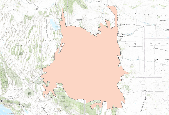
This dataset represents the North Atlantic LCC's ecoregion boundary. Landscape conservation cooperatives (LCCs) are conservation-science partnerships between the U.S. Fish and Wildlife Service, U.S. Geological Survey (USGS), and other federal agencies, states, tribes, NGOs, universities and stakeholders within a geographically defined area. They inform resource management decisions to address national-scale stressors-including habitat fragmentation, genetic isolation, spread of invasive species, and water scarcity-all of which are accelerated by climate change.

Landscape conservation cooperatives (LCCs) are conservation-science partnerships between the U.S. Fish and Wildlife Service, U.S. Geological Survey (USGS), and other federal agencies, states, tribes, NGOs, universities and stakeholders within a geographically defined area. They inform resource management decisions to address national-scale stressors-including habitat fragmentation, genetic isolation, spread of invasive species, and water scarcity-all of which are accelerated by climate change.
Land transformations occurring from energy development and agrarian use have altered the natural connectivity of fish communities inhabiting prairie waterways. The nation’s prairie waterways are obstructed by thousands of barriers that include road culverts, irrigation diversions, and dams. Connectivity is essential for the long term viability of aquatic species. One of the most promising adaptive management strategies for addressing impacts to aquatic systems by climate change and other landscape stressors is increasing connectivity. The purpose of this research is to characterize swimming abilities of three northern plains fish species; the sauger, the longnose dace, and the fathead minnow. The results of the...
Categories: Data,
Project;
Types: Map Service,
OGC WFS Layer,
OGC WMS Layer,
OGC WMS Service;
Tags: 2011,
2012,
2012,
Data Acquisition and Development,
EARTH SCIENCE > LAND SURFACE > LANDSCAPE,
Map drained wetland basins in the PPR of Iowa and complete data set for the eastern (Region 3) of the U.S. Prairie Pothole Regionl. These data form the foundation for a newly launced inititative to develop an “Integrated Conservation Design Strategy for the PPR of Minnesota and Iowa.” This new initiative integrates wildlife habitat, water quality and flood attenuation objectives with wetland restoration potential maps to develop multi-objective wetland restoration plans for landscape-scale watershed.
Categories: Data,
Project;
Types: Map Service,
OGC WFS Layer,
OGC WMS Layer,
OGC WMS Service;
Tags: 2010,
2011,
2012,
2013,
2014,
Rapid expansion of cropland threatens grassland ecosystems across western North America and broad-scaleplanning can be a catalyst motivating individuals and agencies to accelerate conservation. Sprague’s Pipit(Anthus spragueii) is an imperiled grassland songbird whose population has been declining rapidly in recent decades.Here, we present a strategic framework for conservation of pipits and their habitat in the northern GreatPlains.We modeled pipit distribution across its million-km2 breeding range in Canada and the U.S.We describefactors shaping distribution, delineate population cores and assess vulnerability to future grassland losses. Pipitsselected landscapes with a high proportion of continuous grassland...
Categories: Data,
Publication;
Types: Citation,
Map Service,
OGC WFS Layer,
OGC WMS Layer,
OGC WMS Service;
Tags: 2010,
2010,
2011,
2011,
2012,
|

|
